48 F. high in the Twin Cities Monday.
54 F. average high on April 8.
61 F. high on April 8, 2012.
5.1" precipitation since January 1
4.16" average precipitation since January 1, to date.
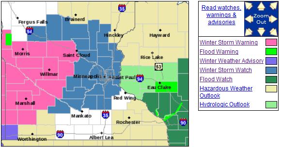
Winter Storm Watch posted from this evening into Thursday.
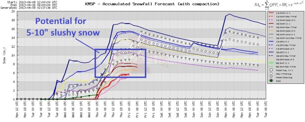
4-8" of slush possible Wednesday into Thursday, heaviest amounts on lawns/fields, especially north metro.
Just the Messenger
May I be excused, please?
This might be a good time to drive south to a slightly warmer, more meteorologically hospitable spot, like Dubuque.
A friend of mine, Tim, reports local fast-ball
softball teams are driving as far south as Illinois and Kansas City to
find (thawed) ball fields to play on. Our stunted spring has many of us
in a funk, and things are about to get even more "interesting".
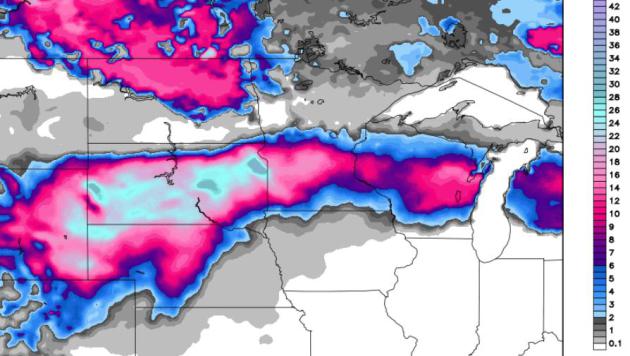
A slow moving storm tracking across the Plains
will spray a fire-hose of Gulf moisture northward - flooding rains for
the Midwest & heavy wet snow from the Upper Mississippi Valley into
the Dakotas, where some 20-30 inch amounts are predicted. Good grief. A
cold rain today mixes with ice tonight and Wednesday, a plowable (4-8"+)
pile of slush may reach the metro area from Wednesday into Thursday;
heaviest amounts on lawns, fields and dazed robins.
Thursday may be the most challenging travel day.
Note to self: I shouldn't have taken off my snow tires - but at least I left my driveway stakes in.
It's baffling: the maps look like something out
of early March. The most snow from an April storm? 13.6" on April 14,
1983. If we pick up 6.7" (possible) it would be the most April snow
since 2002.
Biggest Single Day April Snowfalls In The Twin Cities? I was really hoping not to have to include this data from the Minnesota State Climatology Office:
Rank Value Ending Date
1 13.6" 4/14/1983
2 8.9" 4/7/1923
3 8.8" 4/14/1949
4 8.5" 4/13/1928, 4/27/1907, 4/20/1893
7 7.2" 4/4/1957
8 7.1" 4/27/1908
9 6.6" 4/21/2002, 4/29/1984
Something For Everyone. Everything except sunshine
and 70s. Flood watches for Wisconsin, a Winter Storm Watch for the Twin
Cities, and Winter Storm Warnings west of St. Cloud. Details on the
Winter Storm Watch from the
Twin Cities NWS:
...WINTER STORM WATCH REMAINS IN EFFECT FROM TUESDAY EVENING
THROUGH THURSDAY AFTERNOON...

A WINTER STORM WATCH REMAINS IN EFFECT FROM TUESDAY EVENING
THROUGH THURSDAY AFTERNOON.

* TIMING: LIGHT RAIN WILL TRANSITION TO A WINTRY MIX OF
  PRECIPITATION ON TUESDAY EVENING AND CHANGE OVER TO SNOW LATE
  WEDNESDAY.

* MAIN IMPACT: SNOW ACCUMULATIONS OF 6 INCHES OR GREATER...
  MAINLY BETWEEN WEDNESDAY EVENING AND MID DAY THURSDAY.

* OTHER IMPACTS: SMALL ICE ACCUMULATIONS DUE TO SLEET AND
  LIGHT FREEZING RAIN ON TUESDAY EVENING AND WEDNESDAY.

PRECAUTIONARY/PREPAREDNESS ACTIONS...

A WINTER STORM WATCH MEANS THERE IS A POTENTIAL FOR SIGNIFICANT
SNOW...SLEET...OR ICE ACCUMULATIONS THAT MAY IMPACT TRAVEL.
CONTINUE TO MONITOR THE LATEST FORECASTS.
Hey...It'll Melt. Last night I complained about the
snow to my wife of 28 years. She told me to shut up. "It'll melt", she
said. True enough. The GFS is still going nuts, showing some 12-16"
amounts, which could happen, if there is no wintry mix (sleet and
freezing rain); if precipitation falls as ALL SNOW. This could happen,
but I still expect some rain, sleet (ice pellets) and freezing rain to
mix in, especially today and the first half of Wednesday, which will
keep amounts down in the far more reasonable range of 5-8", maybe 10"
far northern suburbs. But hey, it'll melt.
I Can't Quite Believe It Either. I want to dismiss
this as utter nonsense. It's the second week of April! As far as the
atmosphere is concerned it's the first week of March. There's enough
cold air in place for some 1-2 foot snowfall amounts from eastern
Wyoming into South Dakota; maybe 18" for west central Minnesota and a
cool foot for St. Cloud.
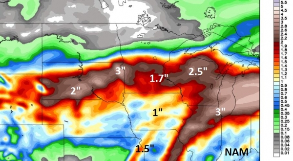
The NAM is hinting at 4-8" for the immediate MSP metro
by Friday morning, with the heaviest amounts north and west of town (on
lawns and fields). I feel the sudden urge to drive (run?) south - as
fast as I can.
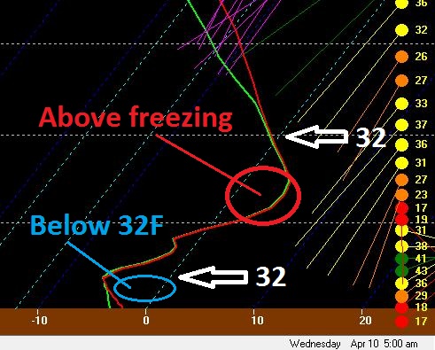
Potential For Glaze Ice Tonight. I expect a cold
rain today, but surface temperatures should dip just below 32F later
tonight, allowing rain to freeze into glaze in time for rush hour
Wednesday morning. Plan on leaving a lot more time to get around
Wednesday and Thursday.
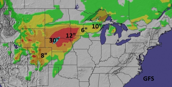
WSI RPM Model. WSI's high-resolution 12km. RPM model
is in pretty good alignment with the NAM, suggesting 8-10" across the
MSP metro, most of that coming Wednesday PM into Thursday, when
temperatures in the lowest mile of the atmosphere bottom out. Some 24"+
snowfall amounts are forecast west of Sioux Falls. What month is this
again?
 One Of The Biggest Snowfalls of Winter - Coming in "Spring"
.
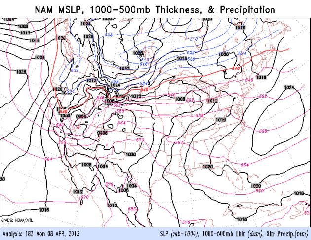
No, the irony isn't lost on me. The 00z NAM shows a major storm
spinning up over the Plains, moving slowly to the east-northeast,
tapping moisture from the Gulf of Mexico, taking a track favorable for
heavy wet snow from South Dakota into Minnesota and Wisconsin.
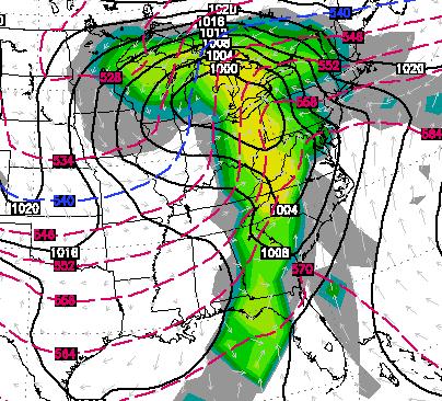
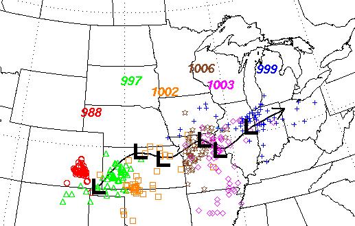 Storm Track
.
NOAA models show a track well south of Minnesota, ensuring a steady
supply of cold air at the height of the storm, Wednesday into Thursday.
The slow forward motion of the storm will help to contribute to
excessive precipitation amounts:
rain and heavy wet snow.
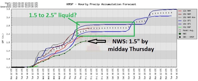
Plenty Of Moisture. I was hoping for rain (to
alleviate the drought), but we'll wind up with more snow than rain this
week. Models suggest 1.5 to 2.5" liquid by Friday morning, more (rain)
Sunday of next week. The good news? I feel more confident than ever
that, based on the cool, wet pattern we're stuck in, the drought will
ease over much of Minnesota by June.
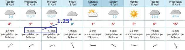
Euro-Trash. Sadly, I think the
ECMWF (European) model is probably on track to verify; hinting at 1.25"
liquid Wednesday and Thursday, much of that moisture falling as heavy,
wet snow.
With high water content in the snow I wouldn't be
surprised to hear reports of downed tree limbs, even some power outages
at the height of the storm. It should be warm enough for rain showers Sunday, readings reach the 50s to near 60 by the middle of next week. Right.
Tracking A Freak April Storm. Here's a
YouTube video
that delves into the reasons for this week's March-like storm, and why
rainfall and snowfall amounts may be very significant, some of the
highest of the winter season: "
Calendar says April 8th, but the
weather maps are much more in line with what you would see in early
March. 20-30" snowfall amounts possible along with the potential for a
few large violent tornadoes. Millions of people will be impacted this
week. Are you one of them? Watch what Meteorologist Paul Douglas has to
say about this freak April storm."
Here is a portion of the briefing that went out from our
Alerts Broadcaster division late Monday:
I'm sitting here, in a Monday funk, mourning the apparent death of
spring, at least over the Plains and Upper Midwest. The calendar insists
that its April 8, but as far as the atmosphere is concerned it's March
1, give or take. An unusually intense storm (for the second week of
April) will impact the central USA with heavy wet snow, heavy rain
capable of urban and river flooding, and deeper into the warm, humid
air, a significant severe storm outbreak, with a potential for a few
large, violent tornadoes: central Plains today and Tuesday, pushing into
the Mississippi Valley and Mid South by Wednesday and Thursday.
Highlights:
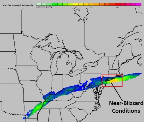
* Near-blizzard conditions are possible in the Denver area Tuesday;
where as much as 5-9" of snow will fall. Expect delays and
cancellations at KDEN, especially tomorrow.
* Models print out some 20-30" amounts across South Dakota, with
plowable snows pushing across Minnesota into Wisconsin Wednesday and
Thursday.
* Chicago may pick up 3" of rain by Thursday, complicating stream
and river flood forecasts - I expect some level of urban flooding as
well.
* A few large, violent, long-track tornadoes are possible tomorrow
from Austin and Dallas to Kansas City. By Wednesday the threat shifts
to Shreveport, Little Rock, Memphis, St. Louis and Louisville. Details:
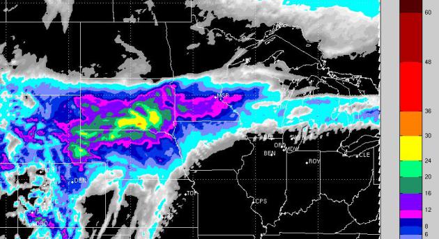
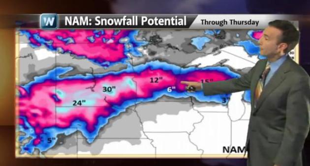
3-5 Week's Worth of Rain by Thursday. The NAM model
prints out very heavy rainfall amounts for the Upper Midwest and Great
Lakes, as much as 2-3" or more of liquid water. Most of that water
will fall as heavy wet snow over the Plains and portions of the Upper
Midwest.
Confirmation. The models are coming into alignment,
showing the heaviest snowfall amounts from Nebraska into South Dakota
and southwestern Minnesota, where some 12"+ amounts seem imminent. This
could still be a plowable snowfall for the Twin Cities by Wednesday
and Thursday, with some 5-10" amounts extending toward Wausau, Appleton
and the Green Bay, Wisconsin markets.
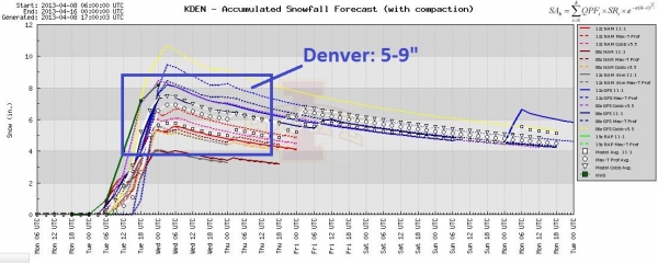
Mile High Mess. Snow arrives tonight in Denver,
peaking tomorrow, when an increase in wind speed may trigger
near-blizzard conditions. I'm comfortable (wrong word) predicting 5-9"
for the Denver area by the time snow tapers Wednesday.
Blizzard Potential Index. One of the many
value-added models we run here at Alerts Broadcaster is the BPI, the
Blizzard Potential Index, factoring in snowfall rates, wind speeds and
predicted visibilities. The worst of the storm along Colorado's Front
Range is forecast to come Tuesday afternoon.
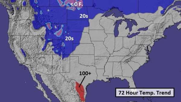
Remarkable Extremes. I don't think I've ever seen
this. Alerts Broadcaster models predict highs topping 100F over
southern Texas, while holding in the 20s over Colorado and New Mexico
over the next 72 hours. The resulting temperature gradient will help to
spin up an unusually intense storm over the Plains states.
On Track For A Significant Severe Storm Outbreak.
Although not as expected to be as violent as outbreaks in 2011, the
stage is set for supercell thunderstorms capable of large, long-lasting
tornadoes capable of significant destruction. The risk is greatest
tomorrow from Dallas to Oklahoma City and Wichita - the threat shifts
into the Mississippi Valley by Wednesday.
Friday Storm Potential. A few severe thunderstorms
are likely in the Atlanta area late Thursday, possibly pushing into
D.C., the Delaware Valley and New York City by Friday afternoon.
Although the potential for tornadoes will be small, some storms may
produce large hail and damaging straight-line winds. Friday's PM
commute may be a real mess across the Northeast.
Summary: I've seen a lot of things in 40 years of
meteorology, but I can't remember the last time I saw 20-30" snowfall
amounts during the second week of April. Portions of the High Plains
may be temporarily shut down, starting tomorrow, spilling over into
Thursday. Disruptions to travel and the power grid may be considerable,
especially from Denver into Nebraska and South Dakota. Ice changing to
snow will create poor to treacherous travel conditions over Minnesota
and Wisconsin. The worst conditions at KMSP (Twin Cities) and KMKE
(Milwaukee) will probably come Thursday.
The
slow forward motion of the storm will prolong rainfall across the
Midwest, accelerating run-off and stream/river flooding, especially
southern Wisconsin into the Chicago and Indianapolis area by midweek.
Ask Paul. Weather-related Q&A:
Paul,
Is
there an easy place to get searchable records for actual snowfall
totals by location and date? Looking to compare each month of the
2012-2013 Winter season in my neck of the woods (or stretch of the
prairie - I'm on the edge)
I stumbled around NOAA for awhile and ended up chasing my tail.
Kelly Larson
Bagley, Minnesota
I asked climate guru Pete Boulay at the Minnesota Climatology Working Group for his advice - here was his answer:
"You can find the closest snow data to your location by going here:
It appears as though the closest place with at least partial data is site 210643 (Bemidji Airport)."
Pete
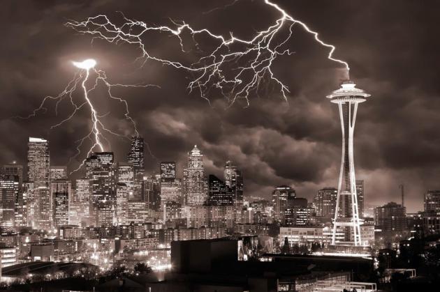
Lightning Hits The Seattle Space Needle. At first I thought this photo was Photoshopped, but that is apparently not the case - this amazing image courtesy of
Smithsonian.com: "
Photo
of the Day: March 15, 2013. An Editors' Pick from our 2012 Photo
Contest. Photo and caption by Clane Gessel (Seattle, WA);
Photographed August 01, 2010, Seattle, WA."
Climate Change And Turbulence Link? Warmer Air Could
Mean A Bumpier Airplane Ride. Great. This is just what I want to read
before getting onto a flight. I'd like a seat in the Black Box please.
Here's an excerpt from
Huffington Post: "
Transatlantic
airline passengers might expect to stay seated with their seatbelts
securely fastened more often in the future, according to new research
that finds climate change could lead to more airplane turbulence. By
the middle of the century, turbulence strength
over the North Atlantic flight corridor could increase between 10
percent and 40 percent, and turbulence frequency could jump between 40
percent and 170 percent, according to the new study published online
today (April 8) in the journal Nature Climate Change. The increase could
have major implications for the airline industry, as approximately 600
flights a day make the North Atlantic transit from Europe to North
America and back. The study researchers focused on clear-air turbulence,
the sort of bumps that occur even in the absence of clouds or
mountains (which can also give airplane passengers a rocky ride).
Clear-air turbulence occurs when masses of air moving at different
speeds collide in the atmosphere, making it invisible to the naked eye
and nearly impossible to detect using radar or satellite..."
* Here's an abstract of the research referenced in the article above, from
Nature.
How Aereo And The Dish Hopper Could "Dramatically Reshape" The Television Industry.
I'm interested in new technologies that are disruptive. Aereo (and the
Dish Hopper, which allows consumers to automatically skip all
commercials on the 4 main networks) fits that definition. Here's an
excerpt of a story at
TVspy: "
A pair of articles in Reuters and The New York Times take a look at the shifting television landscape. Reuters looks at
Aereo and the Dish Hopper, “two fledgling technologies could
dramatically reshape the $60 billion-a-year television broadcast
industry”:
A favorable outcome for Aereo and the Hopper in court would push
TV operators to dramatically reshape themselves. It could even force
them to trade in their broadcast towers and become cable channels
alongside networks such as Bravo, AMC and ESPN, says Garth Ancier, who
has been the top TV programmer at Fox, NBC and the WB networks.
“They won’t have a choice,” Ancier said. “When someone attacks your business, sometimes you do something radical...”
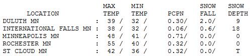
Warm Front.
Yes, Monday was about as mild and springy as it's going to be all week.
Rainfall totals Sunday night and early Monday ranged from .32" at St.
Cloud to .71" Twin Cities. A sharp frontal boundary resulted in some big
extremes; Monday highs reached 55 at Rochester, but only 48 in the Twin
Cities, 42 St. Cloud and 37 at Grand Marais.
TODAY: Cold rain - mainly wet roads. Winds: NE 20-30. High: 38
TUESDAY NIGHT: Winter Storm Watch. Sleet and freezing rain; roads may become very icy. Low: 31
WEDNESDAY: Winter Storm Watch. Ice changes to wet snow. Very slow & slippery. High: 35
THURSDAY: Wet snow; should be "plowable" -
potential for 4-8" snow totals (greatest amounts northern suburbs).
Wake-up: 30. High: 32
FRIDAY: Flurries taper, clouds linger. Wake-up: 28. High: 38
SATURDAY: Partly sunny, almost springy. Wake-up: 26. High: 46
SUNDAY: Milder, PM showers arrive. Wake-up: 37. High: 55
MONDAY: Drier, skies clear. Wake-up: 40. High: near 50
Climate Stories...
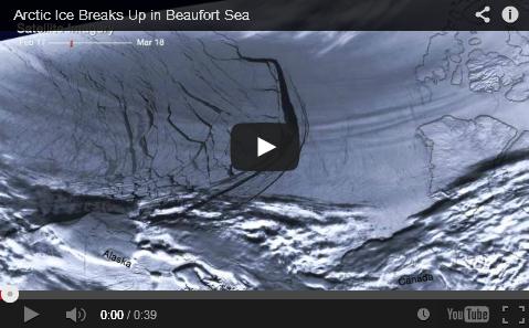
Breaking News (Literally). NOAA Confirms Early Break-Up. Here's a video and excerpt of a story at
Climate Denial Crock of the Week: "...
A
series of intense storms in the Arctic has caused fracturing of the
sea ice around the Beaufort Sea along the northern coasts of Alaska and
Canada. High-resolution imagery from the Suomi NPP satellite shows the
evolution of the cracks forming in the ice, called leads, from
February 17 — March 18 2013. The general circulation of the area is
seen moving the ice westward along the Alaskan coast “Intense storms”
are not an unheard of thing in the arctic. What’s new is that the ice
is so fragile that normal storm activity is breaking it up much earlier
than has been seen in the past..."
Simpler, Cheaper Way To Make Methanol Fuel Using CO2 and Sunlight.
Find a revenue-neutral way to price carbon pollution (one that doesn't
make government bigger) then step back and let the markets do what they
do best: innovate. Here's an excerpt of a fascinating story at
gizmag.com: "
Most
previous methods of producing methanol from carbon dioxide have
involved lots of electricity, high pressures and high temperatures, and
used toxic chemicals or rare earth elements like cadmium or tellurium. A
team of researchers at the University of Texas at Arlington (UTA) has
developed a new method they claim is safer, less expensive, and simpler
than current approaches and can be scaled up to an industrial scale to
allow some of the CO2 emitted from electrical power plants to be
captured and converted into a useful fuel..."
Photo credit above: "
Researchers at University of Texas at Arlington have developed a novel means of creating methanol from sunlight and CO2." (Photo:
Shutterstock)
Oceans May Explain Slow-Down In Climate Change.
90-93% of warming is going into the world's oceans, the balance warming
the atmosphere and melting ice. Here's an excerpt from
Yahoo News: "
Climate change
could get worse quickly if huge amounts of extra heat absorbed by the
oceans are released back into the air, scientists said after unveiling
new research showing that oceans have helped mitigate the effects of
warming since 2000. Heat-trapping gases are being emitted into the
atmosphere faster than ever, and the 10 hottest years since records
began have all taken place since 1998. But the rate at which the earth's
surface is heating up has slowed somewhat since 2000, causing
scientists to search for an explanation for the pause. Experts in France
and Spain said on Sunday that the oceans took up more warmth from the
air around 2000. That would help explain the slowdown in surface
warming but would also suggest that the pause may be only temporary and
brief..."
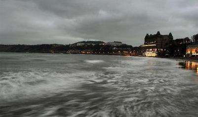
Photo credit above: "
The tide comes in as the sun sets on the seafront in Scarborough, northern England February 26, 2013." REUTERS/Dylan Martinez.
Climate Change Will Threaten Wine Production, Study Shows. Coffee, chocolate, now wine? Say it isn't so. Here's an excerpt from
The Guardian: "
Bid
adieu to Bordeaux, but also, quite possibly, a hello to Chateau
Yellowstone. Researchers predict a two-thirds fall in production in the
world's premier wine regions because of climate change.
The study forecasts sharp declines in wine production from Bordeaux
and Rhone regions in France, Tuscany in Italy and Napa Valley in
California and Chile by 2050, as a warming climate makes it harder to
grow grapes in traditional wine country. But also anticipate a big push
into areas once considered unsuitable. That could mean more grape
varieties from northern Europe, including Britain, the US north-west
and the hills of central China..."
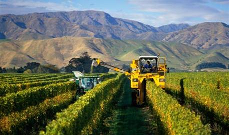
Photo credit above: "
A study has found sharp declines in
wine production from Bordeaux, Rhone and Tuscany, as well as
California’s Napa Valley and Chile by 2050, as a warming climate makes
it harder to raise grapes in traditional wine country." Photograph: Cephas Picture Library / Alamy
Why We Support A Revenue-Neutral Carbon Tax. Here
are two prominent Republicans, George Schultz and Gary Becker, proposing
to tax a known pollutant, but in a way that encourages economic growth
and innovation in the marketplace.
The Wall Street Journal has the story; here's an excerpt: "
Americans
like to compete on a level playing field. All the players should have
an equal opportunity to win based on their competitive merits, not on
some artificial imbalance that gives someone or some group a special
advantage. We think this idea should be applied to energy producers.
They all should bear the full costs of the use of the energy they
provide. Most of these costs are included in what it takes to produce
the energy in the first place, but they vary greatly in the price
imposed on society by the pollution they emit and its impact on human
health and well-being, the air we breathe and the climate we create. We
should identify these costs and see that they are attributed to the
form of energy that causes them. At the same time, we should seek out
the many forms of subsidy that run through the entire energy enterprise
and eliminate them. In their place we propose a measure that could go a
long way toward leveling the playing field: a revenue-neutral tax on
carbon, a major pollutant..."
Study: "Working Together" Won't Fix Climate Change. It's in our DNA to collaborate on big challenges, right? Not so much, argues this article at
Salon; here's an excerpt: "
When
it comes to climate change, we’re all in this dilemma together, and
forcefully addressing it will require collaboration and cooperation. A
stirring sentiment, but if you’re looking to spur white Americans to
action, it’s actually counterproductive.
That’s the conclusion of a Stanford University research team, which
found invoking the idea of interdependence undermined the motivation of
European-American students to take a course in environmental
sustainability. The researchers, led by MarYam Hamedani of
Stanford’s Center for Comparative Studies in Race and Ethnicity, argue
that in mainstream European-American culture, independence functions
as a “foundational schema” — that is, an underlying design or blueprint
that guides behavior..."
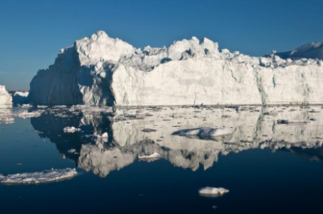
Photo credit above:
AP/Ian Joughin.
Schwarzenegger: California's Silent Disaster. Here's an excerpt of an Op-Ed in the
L.A. Times from the former governor of California: "
I
will always remember the day I woke to the news that more than 2,000
fires were burning in California. I thought I must not have heard
correctly. Two thousand fires? How could that be? In the end, the
state's brave firefighters, joined by contingents from out of state,
won the battle. But not before 11 emergency declarations were issued
and more than 400,000 acres burned. Countless lives and livelihoods
were ruined. Today, there's a new disaster looming, and although it's
not as riveting or dramatic as walls of flames and billowing black
smoke, it needs our immediate attention. The draft National Climate
Assessment, now being circulated for comment and scheduled for release
this year by the U.S. Global Change Research Program, presents a
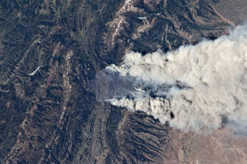
sobering vision of the world that awaits us if we don't act..." (image: NASA).


No comments:
Post a Comment