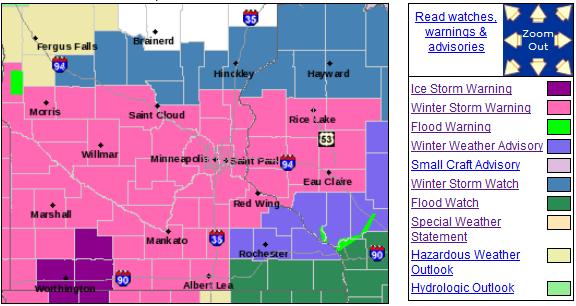
Winter Storm Warning in effect for much of central Minnesota, including the Twin Cities.
1.64" liquid precipitation predicted by Friday (NAM model).
Sleet, freezing rain and snow today - mix will keep amounts down a bit.
Mostly snow tonight into Thursday night, when the most significant accumulations should pile up.
6-12" snow totals possible across much of the
MSP metro area by Friday morning (1-2" possible early today, another
5-10" tonight into early Friday morning).
44 F. high in the Twin Cities Tuesday.
55 F. average high on April 9. Ha!
48 F. high on April 9, 2012.
.33" rain fell at KMSP yesterday.
Trace of snow and sleet Tuesday in the metro area.
The Longest March
"It'll melt" my wife muttered yesterday, sick of
me whining about the prospect of a towering pile of slush - 10 weeks
away from the Summer Solstice.
Just when you thought things couldn't get any
stranger. Here comes another baffling "Black Swan" weather extreme: ice,
sleet and snow today, then heavy snow tonight into Thursday. Our
in-house weather models hint at near-blizzard conditions here Thursday
morning. Models print out over 2" liquid; at least half that amount
falling as heavy, wet, gloppy snow.
Ice, coupled with high water content in the
snow, may bring down tree limbs. I wouldn't be surprised to see some
power outages. Yes, one of the biggest snowfalls of winter will come
during the second week of April.
Even with a snow ratio of 8:1 (8" snow for every
inch of liquid precipitation) the metro may wind up with 6-12" amounts
by Friday - southwest MN could pick up 20-24". This factors in
relatively warm ground temperatures and some melting of snow on contact
(mainly today). Right now Thursday appears to be the worst travel day,
statewide.
Flurries taper Friday morning, peeks of sun
Saturday - the atmosphere warm enough for rain on Sunday. Whew. The
ECMWF shows more light rain/snow by next Wednesday, but nothing like the
next 48 hours.
This may wind up as the biggest April snowfall
since 1983. Before you consider hijacking a southbound barge on the
Mississippi: long-range models show 50s the last week of April.
Light a candle.
Winter Storm Warning. This storm is coming in waves,
the first wave early this morning, falling as a wintry mix of sleet,
freezing rain and some snow; maybe a slushy inch or two early. We should
see mostly sleet today, before a changeover to wet snow tonight and
Thursday, with another 5-8" or more in the metro area. Totals will range
from 6-12", a big variation possible across the metro area. Details
from
NOAA:
A POWERFUL STORM SYSTEM WILL PRODUCE A COUPLE ROUNDS OF WINTRY
PRECIPITATION OVER THE NEXT COUPLE OF DAYS. THE FIRST ROUND OF
PRECIPITATION WILL ARRIVE LATE TONIGHT IN THE FORM OF A WINTRY
MIX OF RAIN...FREEZING RAIN AND SLEET ACROSS MOST OF SOUTHERN
MINNESOTA AND WESTERN WISCONSIN. MORE SNOW IS POSSIBLE ACROSS
CENTRAL MINNESOTA. HOWEVER...SNOW TOTALS WILL BE LIGHT TONIGHT AND
THROUGH THE FIRST HALF OF WEDNESDAY. THE WINTRY MIX COULD CREATE
SOME SLICK SPOTS FOR THE WEDNESDAY MORNING COMMUTE.

A SECOND MUCH MORE SIGNIFICANT ROUND OF WINTER WEATHER IS
EXPECTED LATE WEDNESDAY AFTERNOON INTO THURSDAY AFTERNOON.
ALTHOUGH THERE STILL COULD BE A MIX OF SLEET...RAIN AND SNOW IN
SOUTHERN MINNESOTA AT TIMES LATE WEDNESDAY...MANY LOCATIONS WILL
MAKE THE CHANGE OVER TO MODERATE OR HEAVY SNOW WEDNESDAY NIGHT.
SNOWFALL ACCUMULATIONS OF 10 TO 12 INCHES WITH LOCALLY HIGHER
AMOUNTS APPROACHING 14 OR 15 INCHES ARE EXPECTED IN A BAND
CENTERED ALONG A LINE FROM REDWOOD FALLS...TO THE TWIN CITIES
METRO...TO LADYSMITH IN WISCONSIN. SNOW TOTALS WILL DROP OFF TO
THE NORTH AND SOUTH OF THIS HEAVY BAND TO JUST 4 TO 6 INCHES NEAR
ALEXANDRIA AND LITTLE FALLS AND PERHAPS AS LITTLE AS 3 TO 5
INCHES NEAR THE IOWA AND MINNESOTA BORDER. LOCATIONS IN SOUTH
CENTRAL MINNESOTA SHOULD END UP WITH MORE SLEET AND FREEZING RAIN.
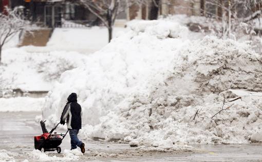
"Heart Attack Snow". Be careful out there - any snow
that falls between now and Friday morning will have a very high water
content, cement-like snow, which will be difficult to get off your
driveway or sidewalk. If you have a heart or respiratory condition think
twice before getting out there and trying to clear your driveway.
(photo credit: AP/Orlin Wagner).
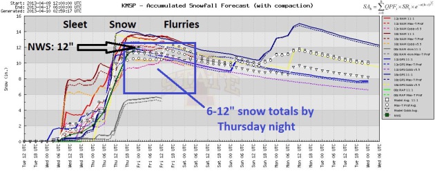
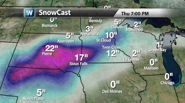
Very Plowable. How much snow ultimately piles up by
Friday morning depends on how long we see a wintry mix today. More sleet
and freezing rain will mean lower snowfall totals, but precipitation
should fall as all snow tonight and Thursday. The local Twin Cities
NWS office is predicting 12", which could very well happen. I'm going
with 6-12", to reflect the wintry mix today, changing to all snow
tonight and tomorrow. Yes, it's going to be a pile.
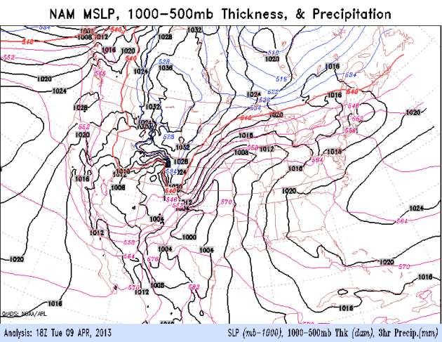
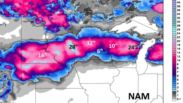
NAM Solution. Here is the 00z NAM solution, showing
some 10-12" amounts close to the metro by Friday morning. The heaviest
amounts will probably pile up just south/west of MSP, closer to Willmar
and Glencoe.
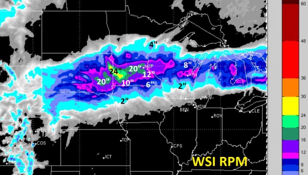
Pass The Smelling Salts. I'm not necessarily buying
this, but in the spirit of full disclosure sharing the 12km. WSI RPM
model output from 00z Tuesday evening, showing some 12"+ amounts for the
Twin Cities, as much as 20" west of MSP. This would require
precipitation to fall as all snow today into Friday morning, which is
unlikely. I could see some 18-22" amounts over southwestern and west
central Minnesota though. That's quite enough for mid-April.
Pulses Of Moisture. The NAM model shows a surge of
moisture tapering this morning; the main event coming tonight into
Thursday, tapering to flurries by Friday morning. A period of sleet may
mix in with the snow tonight, but the lowest 7,000 feet of the
atmosphere should be cold enough for all snow tomorrow. Animation: NOAA.
European Solution. The ECMWF is also hinting at a
mix of sleet, snow and possibly some freezing rain today, with surface
temperatures just above freezing. Hopefully that will keep major roads
wet/slushy. The worst travel conditions will come tonight into Friday
morning, when precipitation should fall as all snow, with air
temperatures at or just below 32 F. The sun peeks out Saturday, enough
warm air aloft for rain on Sunday. Thank God for small favors.
In Search of Spring. I realize the models keep
pushing back any real warmth - it feels like a meteorological mirage,
but I am obliged to share the latest GFS outlook, hinting at 50s, even a
brush with 60 the last week of April. Keep the faith.
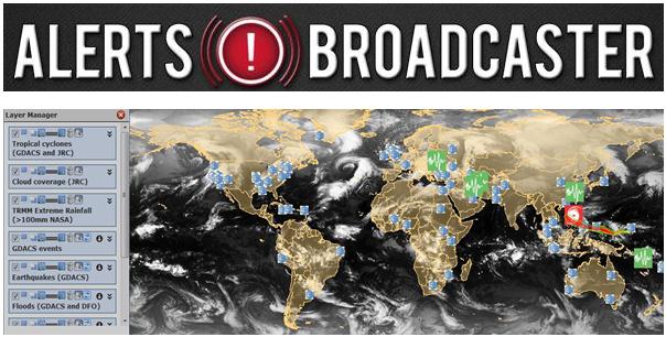
Alerts Broadcaster Briefing: Here is an excerpt of a briefing we issued for our corporate clients on Tuesday:
Much of the east is experiencing May-like warmth with 70s and 80s,
but March is hanging on for dear life over the Plains and Upper
Mississippi Valley. A potentially record April snowstorm is brewing
from northern Nebraska into South Dakota and portions of Minnesota and
Wisconsin, probably one of the 10 biggest April snows on record for
parts of the Upper Midwest. Lovely. A few highlights:
*
1 to 2 foot snows are imminent from northern
Nebraska to Pierre, Sioux Falls and southwestern and west central
Minnesota. On our nuisance-plowable-crippling snowfall rating scale,
this will be crippling for South Dakota and portions of Minnesota, with
as much as 6-12" in the Twin Cities by Friday morning, like something
out of mid-February.
*
High water content (1-2+" liquid) will mean a
very heavy, wet, sloppy snowfall capable of bringing down tree limbs
and power lines. I expect sporadic power outages at the height of this
slop-storm Wednesday & Thursday.
*
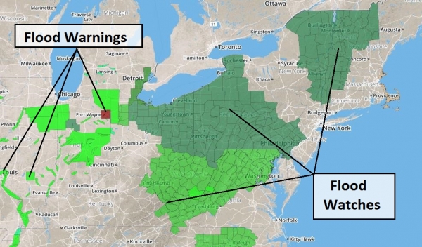
River, stream and urban flooding will accelerate from Wisconsin into the Chicago area over the next 48 hours, as 2-3" rains fall on partially frozen ground.
*
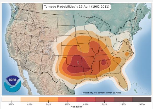
Moderate threat of severe storms over central Oklahoma. I expect a few large, violent, long-track tornadoes from near Oklahoma City to Tulsa this afternoon.
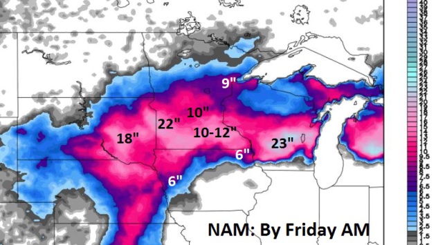
Continuity. We look for consistency and continuity
from model to model, and run to run (4 major model runs daily). The NAM
model also shows a foot of snow for central Minnesota, as much as 28"
near the Minnesota - South Dakota border, with more snow for Wisconsin;
as much as 10-12" for Eau Claire and closer to 20-24" for Green Bay,
Wausau and Appleton, Wisconsin.
This was the 12z Tuesday NAM run; the latest run (up top) is more impressive with snow amounts.
Adonis Model. One of the models we run here at
Alerts Broadcaster is Adonis, which shows some 17-22" amounts from
central South Dakota into southwestern Minnesota, and as much as a foot
of snow into the Twin Cities; lesser amounts for Wisconsin.
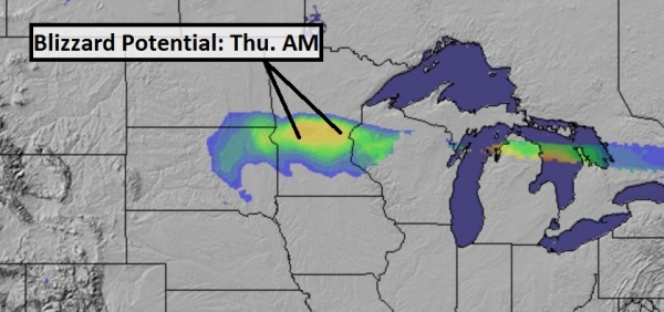
Blizzard Potential Index. Alerts Broadcaster's
proprietary BPI shows near-blizzard conditions pushing across South
Dakota into central Minnesota by Thursday morning. A blizzard is
defined as sustained winds over 35 mph, with visibility under 1/4 mile
in falling/blowing snow. Near-blizzard conditions can't be ruled out in
the northern/western suburbs of the Twin Cities by Thursday.
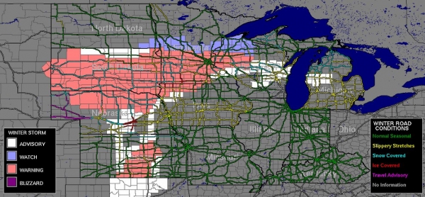
Travel Conditions. Roads are already snow-covered
over South Dakota and southwestern Minnesota. A period of glaze ice
(freezing rain) is likely over central and southern Minnesota by
tonight, changing to mostly snow by Wednesday PM hours. For the latest
road conditions over the Upper Midwest and Great Lakes
click here.
Storm Track. One of the problems with this storm:
very slow forward motion, which will prolong heavy rain, ice and snow,
complicating travel, and increasing the potential for impacts to
facilities and possible power outages. The center of this unusually
intense storm is forecast to reach Ohio by Friday, pushing strong to
severe storms into the Northeast by Friday.
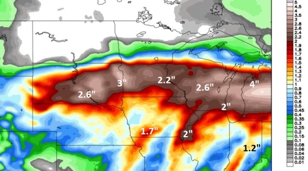
Rainfall Prediction. Many towns from South Dakota
into Minnesota, Wisconsin, northern Illinois and Lower Michigan will
see 2-3 weeks worth of precipitation over the next 72 hours. Keep in
mind the ground is still frozen over most of this region, meaning rain
(and melting snow) will almost immediately run-off into streets,
streams and rivers. I expect flooding reports to increase the latter
half of this week - facilities prone to flooding should stay alert.
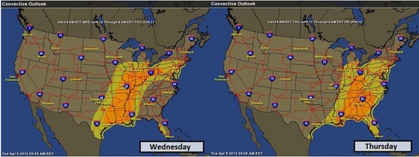
Severe Risk Shifts Eastward. Hail, damaging winds
and tornadoes push into the Mississippi and Ohio River Valley tomorrow;
damaging storms possible as far north as Chicago, Indianapolis,
Columbus, and Pittsburgh. Storms may approach severe limits from
Washington D.C. to Philadelphia and New York City as the front arrives
late Friday.
Latest Watches & Warnings. NOAA has issued warnings from Colorado into the Twin Cities, meaning treacherous, potentially dangerous weather is imminent.
Summary: Much of the central USA will earn it's
spring this year. What will probably be one of the Top 10 April
snowfalls on record will impact a wide swath of the Plains and Upper
Mississippi Valley from today into Friday. River flooding will
accelerate, with the greatest concerns from Wisconsin into Chicago,
Indianapolis and Detroit. The cold, snowy weather has delayed peak
crest for the Red River in Fargo, but added moisture in the snowpack
will probably make a bad situation worse, with an eventual crest still
1-2 weeks away. Deep into the warm, humid air tornadoes are likely
between 2pm and 9 pm today, with the greatest potential for destructive
tornadoes from north Texas into Oklahoma.
This is a volatile, high-impact pattern, affecting 20-25 million Americans over the next 72 hours. We'll keep you posted.
Why Has It Been So Cold This Spring? Live Science has a good explanation; here's an excerpt: "...
This
March, however, the mass of warm air — a high-pressure system that
repels incoming weather systems — has redirected air currents and
created a pattern of winds coming from the Northwest, blasting the
eastern two-thirds of the United States with Arctic air, Carbin said.
"This obstinate mass of warm air over Greenland has redirected air
currents like a rock in a stream," Carbin said. However, the spring season
hasn't been cold everywhere. In fact, the southwestern United States
has been warmer than average, as the region has been unaffected by the
blocking system in the North Atlantic, said Bob Henson, a meteorologist
and science writer with the University Corporation for Atmospheric
Research in Boulder, Colo..."
Why No Seasonal Tornado Forecast? A few brave souls
issue (general) hurricane predictions 2-4 months before the start of
hurricane season (June 1) - why no long range tornado trends our
outlooks? Here's an excerpt of an interesting story at
earthsky.org: "
Every
year, we get new outlooks on the upcoming hurricane season in the
Atlantic. Updates from Colorado State (CSU) typically come in the
winter, and a new outlooks from CSU and NOAA arrive around May, about a
month before the official start of each year’s hurricane season. NOAA
also provides seasonal outlooks projecting who is likely to receive
more/less precipitation and who could see cooler/warmer temperatures.
We all know that these outlooks have flaws; they are not perfect. But
there’s methodology and thought that goes into them, and they are
informative. Meanwhile, we never hear of an official tornado or severe
weather outlook for the United States. Private sector companies or
local national weather service offices might issue their particular
outlook for specific regions, but those outlooks are local and not
widely publicized. Why is no widespread seasonal tornado forecast? This
post will explain why it’s possible to create a yearly outlook for
hurricane season in the summer/fall, but not for tornado/severe weather
season in the spring..."
Graphic credit above: "
Climatology, the scientific study
of climate. can help predict who typically sees the most active severe
weather, but it can’t yet create a seasonal forecast." Image via NOAA/SPC.
Aereo "Prepared For The Controversy" As Fox, Univision Threaten Cable Switch. Television is ripe for disruption - will
Aereo be the technology to pull this off? Here's an excerpt of an interesting perspective from
TVspy.com: "
On
Monday, Fox and Univision both threatened to take their programming
off the broadcast airwaves and convert to cable channels if Aereo
continues to have legal success, The New York Times‘ Brian Stelter reports:
While viewed largely as saber-rattling, the idea that the
networks could be converted into cable channels gained attention in the
television world because such a move would have wide-reaching
implications for viewers and station owners.
The possibility had not been publicly broached by a major broadcaster until Chase Carey, the chief operating officer of Fox’s parent, News Corporation, spoke at a conference of broadcasters on Monday morning..."
* more details from Brian Stelter at
The New York Times.
Sony Announces New, Smaller, "Cheaper" 4K TV Sets.
Yes, HDTV is so 2002. Too bad there's precious little 4k programming.
That will change in the coming years, but do you really want to be an
early adopter? Details from
gizmag.com: "
If the US$24,999 price tag of Sony's flagship 84-inch 4K TV
was a little rich for your blood, then the company's upcoming 55- and
65-inch models might just pique your interest. The $4,999 and $6,999
respective price tags are still fairly hefty, but the company is working
to make the prospect of early 4K adoption that little bit more
appealing by launching its own 4K media player, the FMP-X1, alongside
the new sets..."
Perspective. No, we won't see this much snow.
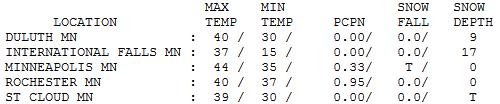
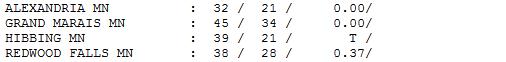
Happy To See (Mostly) Rain Tuesday. It was a cold
rain, mixing with sleet at times. Tuesday highs ranged from 32 at
Alexandria to 39 St. Cloud, 44 in the Twin Cities. Late evening storms
were (borderline) severe over far southern counties of Minnesota - hints
of our stunted spring to come.
TODAY: Winter Storm Warning. Ice, sleet and wet snow tapers at times. Slushy/wet roads. Winds: NE 20. High: 34
WEDNESDAY NIGHT: Winter Storm Warning. Mostly snow, possibly heavy at times. Travel becomes tougher. Low: 30
THURSDAY: Winter Storm Warning. Worst travel day. Heaviest snow. Plowable. 6-12" possible MSP metro. Wake-up: 30. High: 33
FRIDAY: Flurries taper, late PM clearing. Travel conditions slowly improve. Wake-up: 27. High: 37
SATURDAY: Glimmers of sun (and spring), melting snow. Wake-up: 25. High: 43
SUNDAY: Rain likely. What a mess. Wake-up: 34. High: near 50
MONDAY: Mix of clouds and sun. Wake-up: 37. High: 48
TUESDAY: Chance of a little rain. Wake-up: 35. High: 43
Climate Stories....
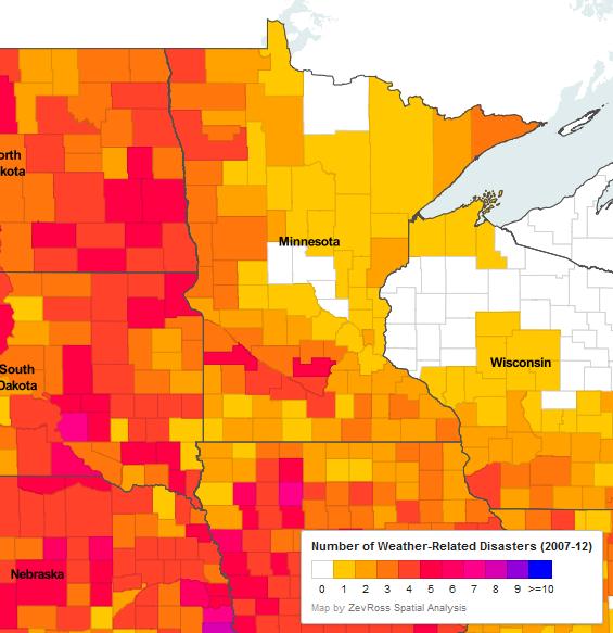
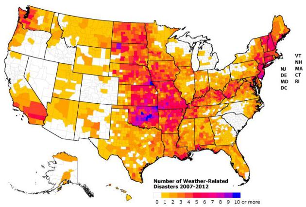
Map Of Recent Weather Disasters In Minnesota. Some remarkable details and graphics from
Environment Minnesota: "
...Higher
temperatures lead to more major rainstorms and heavy snowstorms—for
two reasons. First, warmer temperatures lead to greater evaporation, so
more water in our lakes and oceans becomes airborne. Second, warmer
air can hold more water vapor. This means that when it rains, the
atmosphere will have more moisture to work with and so heavy downpours
and more intense hurricanes are more likely—as is more of the flooding
that often results from these storms. Already, the number of extreme
precipitation events increased 24 percent over the continental U.S.
between 1948 and 2006, and at least 14 weather-related disasters
causing at least $1 billion in damage hit the U.S. in 2011 alone, many
of which involved devastating floods." Check out this interactive map to see which weather-related disasters have hit Minnesota in recent years.
Weather-Related Disasters Since 2007. Map above courtesy of
Environment America.
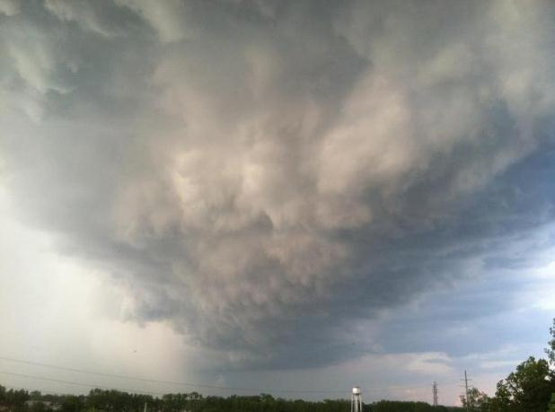
Forecast: More Severe Thunderstorms In A Warming World. My friend and colleague, meteorologist Jason Samenow, has the story at The Washington Post's
Capital Weather Gang: "
Severe thunderstorm season is upon us and dangerous storms are forecast
to develop over the next few days in the Plains and Midwest. Global
warming is often connected with increased extreme weather, but will it
make warm season thunderstorms more severe? On balance, yes – the latest
research concludes: models and theory point to an increase in severe
thunderstorms as the climate warms.
Severe thunderstorms require two primary ingredients:
1) Energy or fuel supplied from hot, humid air to feed violent
vertical storm motions (updrafts and downdrafts). A common metric for
this is a quantity called CAPE, convective available potential energy.
2) Turning winds with altitude, or wind shear to help storms spin. Wind shear is driven by temperature contrasts and is a necessary ingredient for tornadoes..."
Image credit above: NOAA.
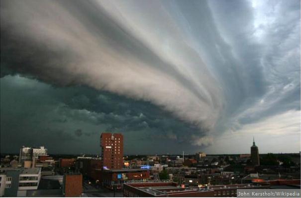
Climate Change In The Southeastern U.S. Could Mean Endless Severe Thunderstorms. You think the weather in Atlanta, Huntsville and Miami is tropical now? Just wait. Here's an excerpt from
The Atlantic Cities: "
Scientists who probe the atmosphere is search of tomorrow's weather have already picked up signs of major heat waves
looming for American cities, particularly eastern 'burgs like Boston,
Baltimore, and Philadelphia. Now NASA is giving us a heads-up that
residents of yet more cities might soon face increased risks of getting
frizzled by lightning or charley-horsed by walnut-sized hailstones.
The space agency has released new weather models based on a 2007 study by Purdue University's Robert Trapp,
who examined what might happen if the concentrations of atmospheric
greenhouse gas were to continue increasing until the end of the century.
Trapp's evidence suggested that by the late 21st century the United
States (and no doubt other places) will have many more days with ideal
conditions for severe thunderstorms – you know, the ones with towering
convective clouds and associated "high-impact weather such as
destructive surface winds, hail and tornadoes..."
Photo credit above: John Kerstholt - Wikipedia.
Don't Just Talk About The Weather. Here's an excerpt of an Op-Ed in the
Baltimore Sun
arguing for weather modification and geo-engineering, to help us deal
with climate change and an uptick in natural disasters. What can
possibly go wrong? "
Last December, an American milestone passed
virtually unnoticed. Forty years earlier, Harrison Schmitt became the
12th and last person to walk on the moon. Mr. Schmitt and the 11 men
who preceded him — beginning with Neil Armstrong in 1969 — had this in
common: All were employees of the United States government. Some have
argued that sending men to the moon may not have been the most prudent
use of American resources or ingenuity. But the realization of President John F. Kennedy's
dream of a U.S. moon walk before the end of the 1960s became a symbol
of the scientific and imaginative leadership of this country and what
Kennedy termed our "freedom doctrine" during the Cold War. Now, the
United States has an opportunity, even an obligation, to mobilize its
resources and knowhow to achieve a more practical, and pressing, end.
Increasingly under siege by destructive and deadly weather events —
wrought, many scientists believe, by man-made climate change — we need
to make a national commitment to weather research, including the fields
of geo-engineering, weather modification and storm mitigation..."
What Does Climate Change Have To Do With Health Care? Here's the intro to a story at
Forbes: "
What
health scientists are telling us is that climate change will bring
increased asthma, more virulent allergens, medical emergencies from
heat stress, the spread of water- and vector-borne diseases and
increased severe weather events. The Lancet, Britain’s premier health
journal, calls climate change “the biggest global health threat of the
21st century.” Given these dire warnings, one would expect that the
healthcare sector would be prepared for the coming public health storm.
Nothing could be further from the truth. When Hurricane Katrina hit
New Orleans, the hospitals were completely flooded along with everyone
else. But because they all had their electrical equipment as well as
their back-up generators in the basement, , they lost all power. And
because none of the windows in the hospital were operable, hospital
staff had to break all the windows in the hospitals’ upper floors to
get air into the facility..."


No comments:
Post a Comment