1.04" liquid precipitation predicted by Friday (NAM model).
7:1 snow ratio - additional snow should range from
5-8" by late Friday night, maybe 10" far northern/western suburbs.
Heaviest snow
falls this morning between 3 am and 10 am; possible thunder-snow - ice
may mix in with the snow at times. Expect a very slow AM commute.
Wet/slushy roads by late afternoon as surface temperatures climb to 33-34F. The drive home should be a little easier.
60F. by April 25? The GFS model thinks so. Me? I'll believe it when I see it, but it has to warm up one of these days.
"Less Riff-Raff"
When I got to Minnesota in 1983 someone quickly
set me straight. "The cold and snow serves a purpose, Paul. It keeps the
riff-raff out."
Really? How did I get in?
That said, I realize if we had San Diego's weather year-round MSP would have a population of 10 million.
The national media will be chatting up today's
snow burst; the heaviest snow coming this morning. Rush hour will be
anything but. A snow ratio of 6:1 or 7:1 will probably mean 5-8 sloppy
inches before snow starts tapers this afternoon.
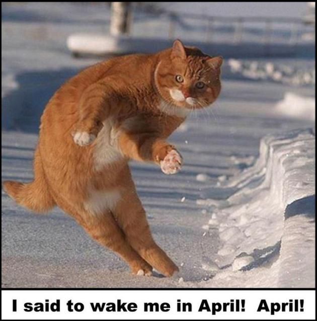
Spring is on life support - but this too shall
pass. The trends are encouraging: more big, wet storms pulling moisture
northward from the Gulf of Mexico. The atmosphere should be warm enough
aloft for rain Sunday, another rain event shaping up by the middle of
next week. Call me a naive optimist (or worse), but I still believe the
drought will ease by June.
Unusual chill and additional snow is delaying
spring flood season, but rain next week may accelerate snow melt. Some
drought counties may experience river flooding, especially along the Red
River. Go figure.
Long-range models hint at 50s next weekend (April 20-21), maybe 60F after the 25th?
I know. I'll believe it when I see it.
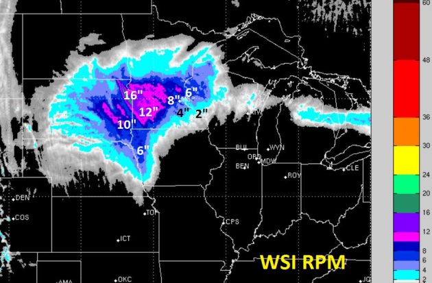
A Sloppy Snowfall. WSI's 4km. RPM model is
suggesting 4-7", with some 8-9" amounts northern and western suburbs by
Friday morning (total). As much as 12-16" could pile up over
southwestern Minnesota, deeper into the cold air.
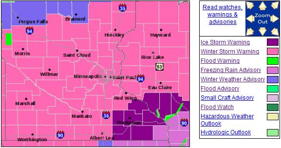 Winter Storm Warning
. NOAA
has
expanded the number of counties under a Winter Storm Warning; now as
far north as Fergus Falls and Brainerd, extending into much of central
and northern Wisconsin. Ice Storm Warnings are posted for southeastern
Minnesota and southwest Wisconsin. Details from the Twin Cities NWS:
...LONG DURATION SIGNIFICANT WINTER STORM TO BRING MORE HEAVY
WINTRY PRECIPITATION THROUGH AT LEAST THURSDAY...
.A POWERFUL STORM SYSTEM WILL BRING WINTRY PRECIPITATION THROUGH
AT LEAST THURSDAY. THE MOST SIGNIFICANT PART OF THIS STORM IS
EXPECTED THROUGH EARLY THURSDAY MORNING...WHEN SNOWFALL RATES
WILL EXCEED AN INCH PER HOUR AT TIMES. ISOLATED THUNDERSTORMS CAN
ALSO BE EXPECTED...WHICH WOULD LEAD TO EVEN GREATER SNOW RATES OF
2 INCHES OR MORE PER HOUR.
PRECIPITATION WILL BE MAINLY SNOW NORTHWEST OF A FAIRMONT...TO
THE SOUTHEASTERN TWIN CITIES METRO...TO RICE LAKE LINE. A MIX OF
FREEZING RAIN...SLEET AND SOME SNOW IS EXPECTED SOUTHEAST OF THIS
LINE...GRADUALLY TURNING TO ALL SNOW BY LATE THURSDAY MORNING.
THIS WINTER STORM WILL HAVE SIGNIFICANT IMPACTS ON THE THURSDAY
MORNING COMMUTE.
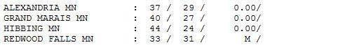
SNOWFALL ACCUMULATIONS OF 8 TO 12 INCHES ARE EXPECTED IN A BAND
CENTERED ALONG A LINE FROM REDWOOD FALLS...TO ST CLOUD AND THE
TWIN CITIES METRO...TO RICE LAKE WISCONSIN. SOME LOCATIONS...
ESPECIALLY THOSE THAT RECEIVE THUNDERSNOW...COULD SEE HIGHER
TOTALS OF 12 TO 15 INCHES. SNOW TOTALS WILL DROP OFF TO THE NORTH
AND SOUTH OF THIS HEAVY BAND TO 6 TO 8 INCHES NEAR ALEXANDRIA AND
LITTLE FALLS...AND PERHAPS AS LITTLE AS 2 TO 5 INCHES NEAR ALBERT
LEA AND EAU CLAIRE WHERE A MIX OF FREEZING RAIN AND SLEET IS
EXPECTED TO PERSIST THE LONGEST. ICE ACCUMULATIONS THERE MAY ALSO
REACH BETWEEN A TENTH AND A QUARTER OF AN INCH.
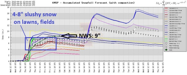
Cue The Dueling Models. It's a little troubling
that, 6-12 hours before a significant snow event, the models still vary
as much as they do, ranging from 2 to 10". I still think something in
the 4-8" range makes sense, based on a snow ratio of 6:1 or 7:1, and a
little rain/sleet mixing in at times. The best chance of 6-8": northern
and western suburbs. The local NWS office was predicting about 8-9" as
of late last night.
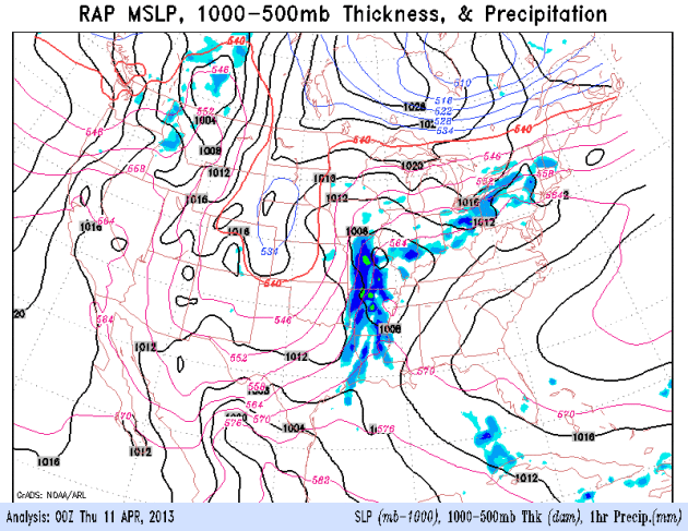 Snow Burst
. The high-resolution RAP model from NOAA
shows
a surge of moisture and energy rotating in from the southeast this
morning; the heaviest snow between 3 am and 11 am or so, when slush may
pile up at the rate of 2"/hour (even some thunder and lightning). Snow
tapers slightly this afternoon - by then many lawns and fields will be
sporting a 5-8" blanket of white.
Progress? No More Slushy Snowfalls. I can't promise
50s looking out 8 days or so, but in all probability we won't have to
hear about "plowable snowfalls" again anytime soon. The atmosphere
should be warm enough aloft for rain Sunday, another chance of rain
showers next Tuesday and Wednesday. ECMWF data above, forecast highs in
Celsius.
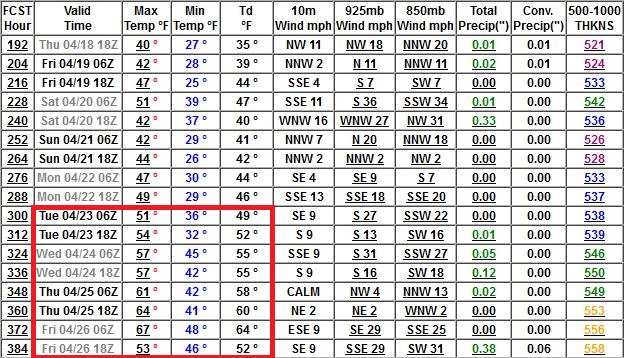
Reason To Go On Living. GFS data is fairly
consistent (at least for the past 2 days), showing highs in the 50s by
April 23, maybe a few 60-degree highs by the 25th? If this forecast
verifies and we do hit 60F. I may encourage the National Weather Service
to sound the sirens, signaling it's safe to come out of extended
hibernation.
Here is an excerpt of an
Alerts Broadcaster Briefing, issued Wednesday afternoon:
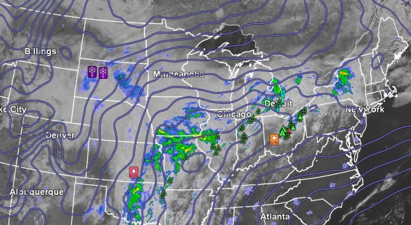
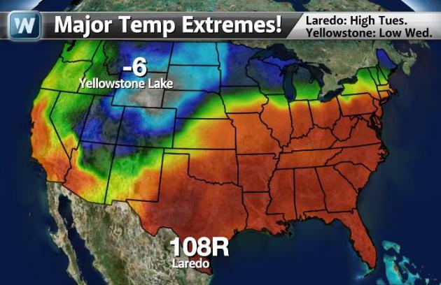
It's one mixed-up weather map: instant July for much of the eastern
seaboard, with record-setting 80s, even a slight shot at 90F in
Washington D.C. later today. Temperatures are 80 degrees colder in
Colorado and the western High Plains, setting the stage for a major snow
storm over the Upper Midwest and Great Lakes, with enough rain to
accelerate stream and river flooding from Iowa and Wisconsin into
Missouri and Lower Michigan. Highlights:
*
Another 4-9" slushy snow may fall on the Twin
Cities tonight thru Thursday afternoon; a plowable snow event. As much
as 15-18" may fall on southwestern Minnesota.
*
River flooding is increasing across the Midwest and Great Lakes; heavy rain falling on partially frozen ground complicating the flood outlook.
*
Severe thunderstorms are likely later today from
the Mississippi River Valley into the Ohio Valley, as far east as
Philadelphia and metro New York City. The odds of tornadoes are low,
but not zero.
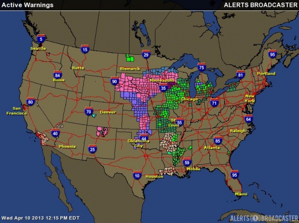
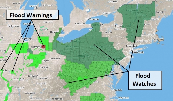
Latest Warnings. Winter Storm Warnings are posted
for much of the Upper Midwest for ice and another round of heavy, wet
snow tonight into Thursday. All the green counties are under Flash
Flood Watches or Warnings. Data courtesy of NOAA.
Most Weather Headaches. Ice Storm Warnings are
posted for southeastern Minnesota and southwest Wisconsin, for a
significant accumulation of glaze ice on roads and powerlines. Some
power outages are possible from Rochester and LaCrosse to Menomonie,
WI. Flood Warnings (bright green counties) are in effect from Wisconsin
into eastern Iowa, northwest Illinois, Lower Michigan and much of
Missouri.
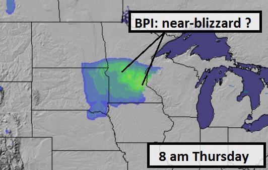
Blizzard Potential Index. One of the models we run
in-house here at Alerts Broadcaster is the BPI, the Blizzard Potential
Index, which factors predicted snowfall rates, wind speeds and
visibilities. Models are suggesting near-blizzard criteria from
Alexandria and St. Cloud into the suburbs of the Twin Cities tomorrow
morning; conditions improving by afternoon. Odds are morning rush hour
will be anything but.
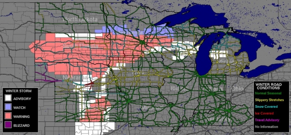
Highway Conditions. Roads are snow and ice covered
from Nebraska and South Dakota into southwestern Minnesota. I expect
travel conditions to worsen again tonight into Thursday, before
improving across the Midwest during the day Friday. Latest conditions
are
here.
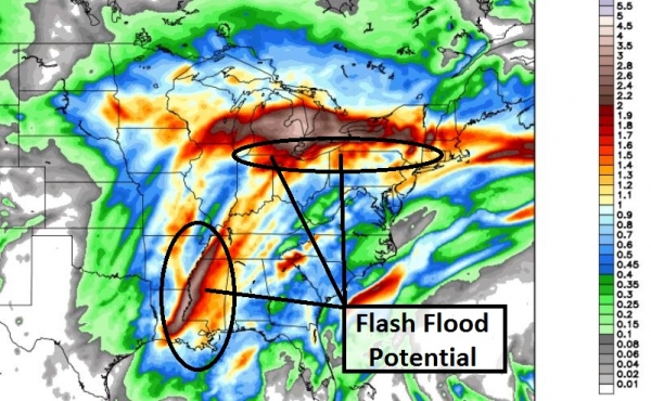
Predicted Rainfall. The NAM model is predicting
some 2"+ precipitation amounts for the Great Lakes and Mississippi
Valley. Much of that moisture will fall as snow over Lower Michigan,
but heavy rain on partially frozen ground may lead to run-off problems
from near Chicago and Detroit into upstate New York, more flash
flooding possible Memphis to New Orleans.
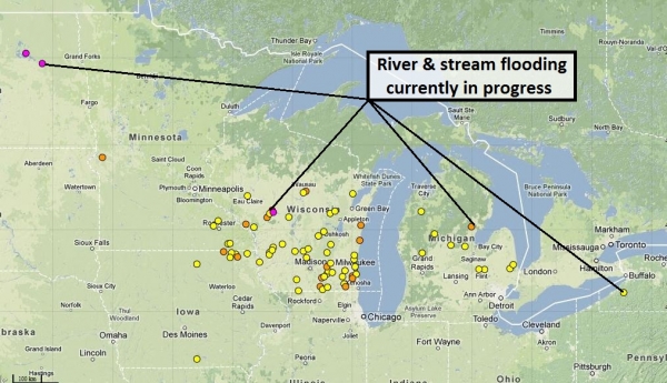
Current River/Stream Flooding. NOAA is reporting
major flooding in Devil's Lake, North Dakota and the East Fork of the
Black River in Wisconsin. Minor to moderate stream/river flooding is
reported across much of Wisconsin, southeastern Minnesota, northeast
Iowa, Lower Michigan and the suburbs of Buffalo, New York.
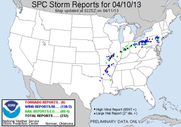
Wednesday Storm Reports. As of late last night 6
tornadoes were reported, most of them in Arkansas, but a few touch-downs
over the eastern suburbs of St. Louis. In all 138 reports of damaging
straight-line winds, with hail and highs winds as far east as metro New
York City. Detailed storm reports from SPC are
here.
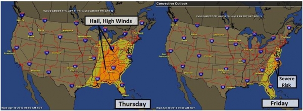
Severe Risk Shifts East. Today the severe risk
extends from the Ohio Valley southward to Huntsville and Atlanta. By
Friday a few storms may exceed severe criteria over the Carolinas and
Tidewater region of Virginia. I could see a few very strong T-storms
Friday from D.C. to New York City.
Summary: Another surge of heavy wet snow and ice
pushes across the Upper Midwest into the Great Lakes into Friday
morning. River flooding continues to increase over the Midwest, and
will be a factor for the next couple of weeks as we continue in a very
wet, unsettled pattern. Severe storms will fire up later today over the
central USA, pushing to the east coast by Friday. We'll continue to
monitor this unusually intense April storm and keep you in the loop.
Major League Extremes. I can't remember the last time I saw this during the second week of April. Strange....
Flood-Weary North Dakota Residents Keep An Eye On Snowmelt As River Peak Headed Toward End Of The Month. The latest details from AP and
The Republic: "
The
annual Red River Valley pastime of moisture monitoring came to a
bone-chilling halt Tuesday when temperatures failed to creep above the
freezing mark in eastern North Dakota and put both the gradual snowmelt
and nervous flood watchers on hold. The last few weeks have seen above
freezing temperatures during the day and below freezing at night, which
are usually conducive to a gradual thaw — but now it's a tad too
chilly for comfort, said weather service meteorologist Greg Gust. "We
aren't doing a good job of getting rid of the snowpack or the water by
conventional means," Gust said, referring to a slow ground thaw and
evaporation. "So at some point it does need to get a bit warmer and
stay a bit warmer to really do this right..."
* experimental long-range flood risk graphic courtesy of
NOAA.
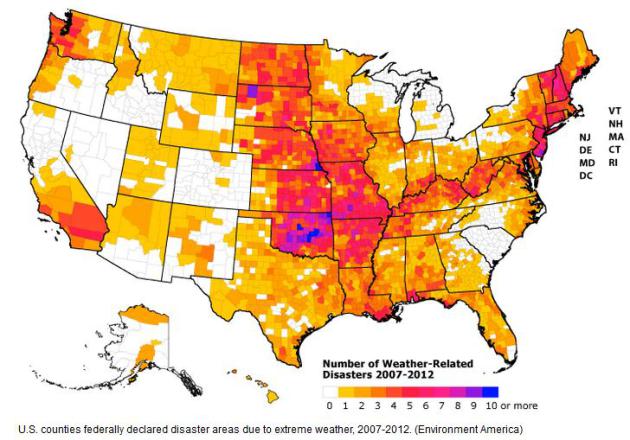
Report: 243 Million Americans Affected By Weather Disasters Since 2007. Here are more details in the latest report from
Environment America, as detailed by The Washington Post - here's an excerpt: "
Among some of the report’s major findings:
- About 4 out of 5 Americans live in counties that have been declared federal disaster areas in the past six years.
- In 2012, the U.S. recorded 11 weather disasters causing economic losses of $1 billion or more, including Hurricane Sandy.
- Sandy claimed 72 lives in the Northeast and caused over
$70 billion in damages, making it the costliest hurricane ever to hit
the East Coast and the costliest weather disaster since Hurricane
Katrina in 2005.
- 77 million Americans live in counties that experienced federally declared weather-related disasters in 2012 alone.
- 19 million Americans live in counties that have averaged one or more such weather-related disasters per year since 2007..."
Broadcasters Circle Wagons Against A Streaming TV Upstart.
More background on how Aereo has the potential to disrupt local
broadcasting, and yes, it's coming to the Twin Cities. Details from the
New York Times
(paywall means a subscription is necessary to read the entire article).
Here's an excerpt: "...The networks aren’t just concerned about Aereo,
which has a tiny following, but about copycats. “
It’s Aereo today,
but it could be something else tomorrow,” said Robin Flynn, a senior
analyst at SNL Kagan. For several decades companies that were lucky
enough to own licenses for local TV stations thrived on advertising
revenue alone, and because there was relatively little competition they
enjoyed huge audiences and profit margins to match. As cable and then
the Internet introduced new competitors, station owners began to rely
on a second revenue source, the so-called retransmission fees that come
from the cable and satellite operators that pick up their signals and
repackage them for subscribers. Now that they’ve had a taste of these
fees, the stations aren’t willing — or able, they say — to go back to
the old model of advertising alone..."
Why Is Addiction Still Considered A Personal Weakness? It's a disease, like epilepsy or diabetes, and yet the stigma is still very strong. Here's an excerpt of an article at
LinkedIn: "
When
we hear about someone with a heart problem, HIV, cancer or diabetes we
conclude they are ill. If we encounter people whose throats close when
they eat peanuts or require epinephrine shots if they mistakenly eat
shellfish, we understand there are aspects of their genetic wiring that
make them susceptible. Yet when we hear about someone with a drug or
alcohol problem, they are all too easily dismissed as weak,
self-indulgent, indolent, sinful, narcissistic, debauched and feeble
failures. Why don’t we assume that drug and alcohol addicts are ill and
often seriously and chronically sick? That’s one of the questions
raised by Clean: Overcoming Addiction and Ending America’s Greatest Tragedy,
David Sheff’s new book that studiously documents his reflections on
the place of addicts in America. Sheff knows whereof he writes. He
documented the calamity of drugs in his previous work, Beautiful Boy,
which described in horrifying detail the descent into life’s basement
of his son, Nic, who took his first puff of pot at the age of 12,
feasted on pills of all concoctions, later started shooting up cocaine,
heroin and crystal meth and subsequently ricocheted between the
streets, halfway houses and all manner of treatment centers..."
The Man Who Pierced The Sky. Here's an excerpt of a fascinating read from
Vanity Fair: "
When
Felix Baumgartner set out to make a living by stunt jumping—from
cliffs, buildings, and bridges—the young Austrian had no idea where it
would take him: to a pressurized capsule nearly 24 miles above New
Mexico, last October 14, preparing to free-fall farther than any man in
history, and at supersonic speed. Detailing Baumgartner’s quest,
William Langewiesche explores what drove him to ever greater heights..."
Photo credit: "
Felix Baumgartner, at the summit of Hoher Kasten, Switzerland, a few months after his record-setting free fall." Courtesy: Vanity Fair.
The End Of Sleep? Will new technologies make sleep optional? What a sad world that would be. Here's a snippet of a story at
aeonmagazine.com: "...
With
military personnel in mind, ABM has developed a mask called the Somneo
Sleep Trainer that exploits one- or two-hour windows for strategic
naps in mobile sleeping environments. Screening out ambient noise and
visual distractions, the mask carries a heating element around the
eyes, based on the finding that facial warming helps send people to
sleep. It also carries a blue light that gradually brightens as your
set alarm time approaches, suppressing the sleep hormone melatonin for a
less groggy awakening. Sleep ideally contains multiple 60- to
90-minute cycles, from slow-wave sleep back up to REM, but a 20-minute
nap is all about dipping into Stage 2 as quickly as possible. The idea
of the Somneo is to fast-track through Stage 1 sleep, a gateway stage
with few inherent benefits, and enter Stage 2, which at least restores
fatigued muscles and replenishes alertness..."
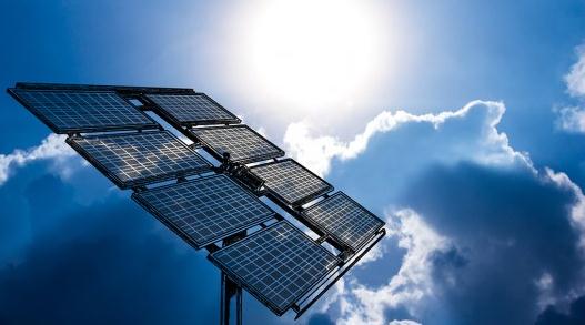
Spectrolab Claims Record Efficiency For New Solar Cell. I thought this was vaguely interesting; an excerpt from
gizmag.com: "
Spectrolab,
a Boeing subsidiary known for the manufacture of solar cells for
satellites and spacecraft, has in recent years turned its attention to
terrestrial solar cells to tap into the expanding alternative energy
market. Now the California-based company has claimed a new solar cell
efficiency record of 37.8 percent for a ground-based multi-junction
cell without solar concentration. While Spectrolab and others
have achieved higher efficiencies with multi-junction solar cells,
these were done using sunlight concentrated by lenses or mirrors onto
the solar cells. The company says it was able to set a new record
without concentration using a new class of high-efficiency
multi-junction solar cell..."
Photo credit above: "
Spectrolab has achieved a record 37.8 percent efficiency with a new multi-junction solar cell (not pictured)." (Photo:
Shutterstock).
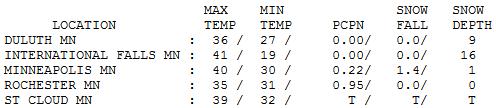
40 F. high Wednesday in the Twin Cities.
55 F. average high for April 10. Right.
44 F. high on April 10, 2012.
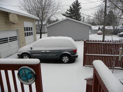
1.4" snow fell late Tuesday night into Wednesday morning as the first wave of precipitation moved thru the metro.
Calm Before The Slop-Storm. After a slushy start wet
snow tapered off, roads mostly wet after 9 am or so as temperatures
rose well above 32F. Rochester picked up .95" rain as of 7 pm, .22" Twin
Cities, only a trace at St. Cloud.
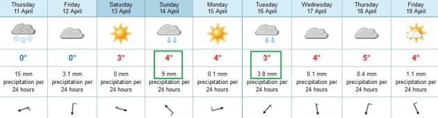
TODAY: Winter Storm Warning. Wet snow, heaviest morning hours. Slow & slushy travel. Winds: NE 20. High: 34
THURSDAY NIGHT: Periods of light snow and
flurries; total accumulations of 5-8" across much of the MSP metro; some
10" amounts possible far northern and western suburbs by Friday
morning. Low: 28
FRIDAY: Flurries linger, additional coating-1" of snow possible early. High; 36
SATURDAY: Sunny breaks, snow melts rapidly. Wake-up: 26. High: 43
SATURDAY NIGHT: Slight chance of a light rain/snow mix. Low: 33
SUNDAY: Cold rain likely. Seriously sloppy. High: 45
MONDAY: Partial clearing, pretty quiet. Wake-up: 34. High: 48
TUESDAY: Cloudy, rain showers late. Wake-up: 36. High: 47
WEDNESDAY: Chance of rain, especially south/east of MSP. Wake-up: 34. High: 42
Climate Stories....
U.S. Admiral: Global Warming Threat Dwarfs North Korea. This one made me do a double-take; here's an excerpt from
WND: "
The
military officer charged with monitoring North Korea at a time when
the rogue nation is threatening to unleash missile attacks worldwide
has used a Senate hearing to double down on his claim that it is global
warming that is the real danger. Navy Adm. Samuel Locklear III
originally caused a stir just weeks ago when in a speech to scholars at
Harvard and Tufts universities in Cambridge, Mass., he said the
climate change factor should be the focus of American concern. At
today’s hearing before the Senate Armed Services Committee he defended
his assessment that global warming is the greatest threat to security
in that part of the world..."
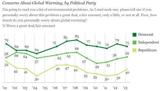
Republican Skepticism Toward Global Warming Eases. The graphic and story from
Gallup: "
Democrats
and Republicans retain markedly different views about global warming,
with 75% of Democrats versus 40% of Republicans saying they personally
worry about it a "great deal" or "fair amount." Both groups' levels of
concern about global warming have fluctuated in recent years.
Republicans -- as well as independents, at 59% -- show slightly
increased levels of worry in 2013, following 10-year lows in 2010 and
2011. Concern has held steady at a high level among Democrats throughout
the past decade..."
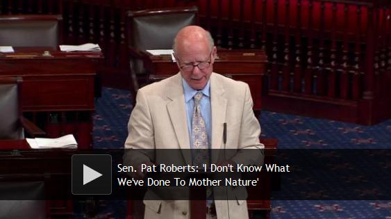
Pat Roberts: "I Don't Know What We've Done To Mother Nature".
Pat Roberts is a Republican politician from Kansas, who is as baffled
about the recent weather in his home state as his constituents.
Huffington Post has the video of his testimony; here's an excerpt: "
Sen.
Pat Roberts (R-Kan.) took to the Senate floor Tuesday to lament the
need for crop insurance, pointing out that extreme weather has battered
the nation in recent years. He cited historic drought and floods in
the Midwest and Superstorm Sandy in the East. But Roberts, who receives poor ratings from environmental groups,
avoided linking the natural disasters to any kind of human-generated
climate change, suggesting Mother Nature simply has it in for America.
"I don't know what we've done to Mother Nature, but she sure hasn't been
very kind to us," Roberts said. The senator has previously acknowledged
that the globe is warming, but declared he didn't know what it meant,
saying of the science that connects greenhouse gases to climate change:
"A lot of this is condescending elitism."
The Government Accountability Office earlier this year added climate
change to its list of the greatest risks facing the federal government.
Nearly all scientists agree that humans are most likely to blame for
the planet's rapid warming, according to NASA..."
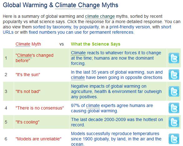
Global Warming And Climate Change Myths. Uncle Joe
still thinks it's all some left-wing, liberal, one-world, U.N.
conspiracy? Here are a few suggestions for debunking some of the
prevailing climate change (myths) from
Skeptical Science: "
Here is a summary of global warming and climate change
myths, sorted by recent popularity vs what science says. Click the
response for a more detailed response. You can also view them sorted by taxonomy, by popularity, in a print-friendly version, with short URLs or with fixed numbers you can use for permanent references."
Climate Change Included In U.S. Education Guidelines For The First Time. Here's an excerpt of a story at
The Guardian: "
American school children will for the first time receive extensive lessons on climate change following the adoption on Tuesday of new science
education guidelines. However, the final standards were substantially
weakened from earlier drafts. The final guidelines cut by about a third
the amount of time devoted to a subject seen as critical to future
generations. They are also less explicit than earlier drafts about the
human role as a driver for climate change. "It's buried at best," said
Mark McCaffrey, policy director for the National Center for Science
Education..."
Photo credit above: "
The final standards are much more vague about the causes of climate change." Photograph: Kevin Schmidt/Corbis.
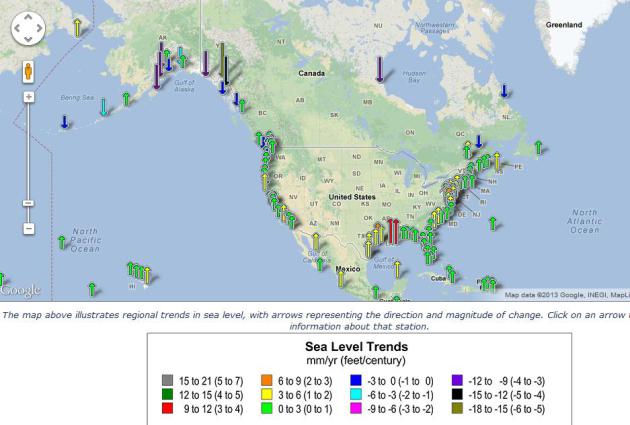
Sea Level Rise. I'd think twice about buying coastal
property, especially in Louisiana. At Grand Isle, LA sea levels are
rising at the rate of 9.24 mm/year, with a 95% confidence level,
according to
NOAA.
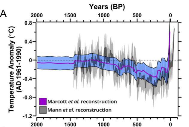
Setting The Temperature Record Straight: The Last 11,300 Years Explained. Climate Science Watch and Climate Nexus have details on a recent study (Marcott) that has generated controversy; here's an excerpt: "
Authors
Marcott et al. recently published a study of global temperatures over
the Holocene period, or past 11,300 years. The study reconstructed past
temperatures using data from sources such as ice cores and ocean
bottom cores that are known to record changes in temperature, allowing
them to be used as proxies in the absence of a thermometer record. The
study found that current temperatures measured by thermometers are
warmer than a large majority (~75%) of the temperatures of the last
11,300 years. In interviews, the authors explained that the warming
trend over the past century is more rapid than temperature changes that
took place over the past 11,300 years. The study conclusions and author
interviews received harsh criticism from some..." (graphic:
The Atlantic).
When The Earth Moved: What Happened To The Environmental Movement? Great question. Here's an excerpt of a must-read article from Nicholas Lemann at
The New Yorker: "...
Then,
forty years after Earth Day, in the summer of 2010, the environmental
movement suffered a humiliating defeat as unexpected as the success of
Earth Day had been. The Senate Majority Leader, Harry Reid, announced
that he would not bring to a vote a bill meant to address the greatest
environmental problem of our time—global warming. The movement had
poured years of effort into the bill, which involved a complicated
system for limiting carbon emissions. Now it was dead, and there has
been no significant environmental legislation since. Indeed, one could
argue that there has been no major environmental legislation since
1990, when President George H. W. Bush signed a bill aimed at reducing
acid rain. Today’s environmental movement is vastly bigger, richer, and
better connected than it was in 1970. It’s also vastly less
successful. What went wrong?..."


No comments:
Post a Comment