79 F. high yesterday in Minneapolis - St. Paul.
74 F. average high for May 31.
66 F. high on May 31, 2012.
.25" rain fell yesterday at Twin Cities International Airport.
6.24" rain fell in May in the Twin Cities.
3.36" normal rainfall for May.
9.34" rain fell during May, 2012.
Glass Half Full
At the 8th annual SAVE (suicide awareness,
voices of education) Fashion Show on Thursday a woman came up and
actually THANKED me for the weather. The only person to do so all year.
Really? "Paul, I'm saving money on air conditioning and sunscreen; I
haven't had to water my yard all spring! Lower melanoma risk too." I
hadn't thought of it that way, but she has a point.
That said, most of us feel cheated. "Where's my warm front? Why can't we enjoy a sunny, lake-worthy Saturday!?"
According to Mark Seeley it was the wettest
spring on record for southeastern Minnesota, where some counties shifted
from drought to flood in the meteorological blink of an eye.
A cold swirl of low pressure aloft sparks more
rain showers today; mainly PM hours. A north breeze and cool 60s will
provide free A/C. The sun comes out tomorrow - temperatures 10 degrees
below average. Only the brave & foolish will be in the water.
Blame a southward shift in the jet stream; maps look more like May 1 than June 1. The Time Warp of 2013.
Keep checking the blog for updates on a possible Gulf of Mexico (or Florida) tropical system brewing for late next week.
More good news: no earthquakes, tsunamis, volcanoes or sandstorms in sight!
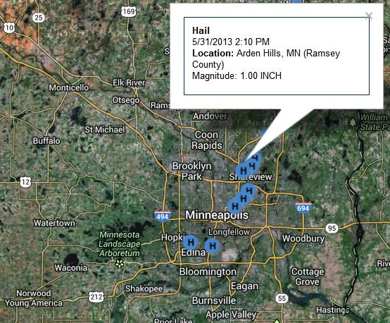
Friday "Hailers". T-storms
bubbled up in a hurry yesterday afternoon, producing a trail of 1" hail
from Edina and Richfield to Arden Hills and Roseville, a period of
torrential rain for downtown Minneapolis. SPC issued a Severe Storm
Watch for the eastern suburbs and Wisconsin; big storms popping along
the leading edge of a cooler front. Details from the
KMPX Twin Cities office of the National Weather Service.
* record May rainfall in Oklahoma City; over 12" has fallen at KOKC. The drought is over.
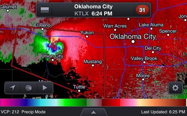
Another Tornado Emergency. Here's a RadarScope image
showing velocity fields at the height of yesterday's rain-wrapped
(multi-vortex) tornado that hit the western and southern suburbs of
Oklahoma City. It's been a terrifying month for local residents, light
to moderate damage reported again in Moore, hit so hard by an EF-5 early
last week. Thanks to WeatherNation TV meteorologist Susie Moore for the
image.
The Dark Side of Tornado Chasing. Sometimes you
chase the tornado - sometimes the tornado chases you. I'm relieved Mike
Bettes from The Weather Channel is OK, reports of bumps, bruises and
cracked ribs as the vehicle was rolled during yesterday's freak tornado
outbreak. This twister was erratic, a "right-turner" - it veered to the
right, catching many storm chasers offguard. Yesterday there were
hundreds, possibly thousands of tornado chasers converging on Oklahoma
City, professionals and amateurs. One of these days there's going to be a
terrible tragedy among the chaser/spotter community. Yesterday we got a
glimpse of how things can go south (literally) in a hurry.
Saturday Severe Threat.
Oklahoma City gets a break today - finally, as a frontal boundary
finally pushes east. Hail, damaging winds and isolated tornadoes are
possible fro Dallas to Memphis, Chicago, Louisville and Cleveland,
according to NOAA SPC.
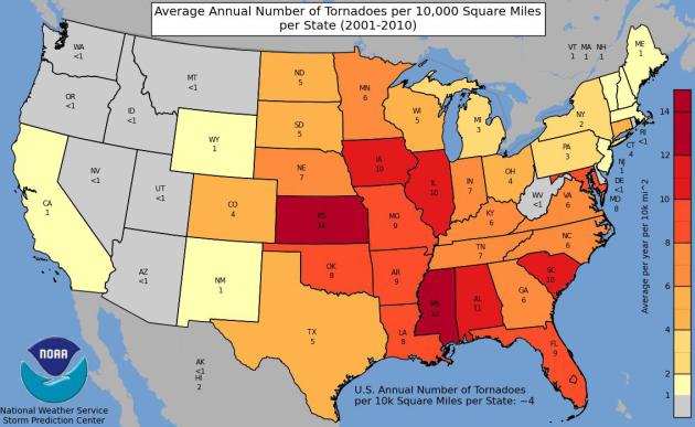
Tornado Distribution: 2001 - 2010.
Here's an interesting map from NOAA, showing an apparent eastward shift
in Tornado Alley. South Carolina and Alabama saw as many tornadoes per
10,000 square miles as Iowa and Oklahoma. Peak states for tornado
touchdowns last decade: Kansas and Mississippi.
A May To Remember (Or Promptly Forget). Amen. Here's an excerpt from this week's edition of
WeatherTalk, courtesy of Dr. Mark Seeley: "...
Combined
with the precipitation for March and April, the overall spring season
(March-May) was the wettest in history for southeastern Minnesota,
saturating soils, and putting streams and rivers near bank full.
Statewide this spring is likely to end up among the top ten wettest in
history. The snow storm over the first few days of May established some
records in southeastern Minnesota as well. Dodge Center reported a
statewide daily record snowfall for May with 15.4 inches on the 2nd.
Observer reports for snow totals ranged from 9 inches (Albert Lea) to
17.3 inches (Ellendale) across many areas of southern Minnesota in one
of the snowiest Mays in state history..."
More Like October 1. No, it doesn't look like June 1
out there. A cold upper level storm will keep us mostly cloudy and
showery today, temperatures holding in the 60s with a brisk northwest
wind. Expect more sun tomorrow; mid to upper 60s under a (rare) dry sky.
The next system arrives with more rain late Monday into Wednesday of
next week, but the ECMWF model is hinting at upper 70s to low 80s next
weekend. We'll see.
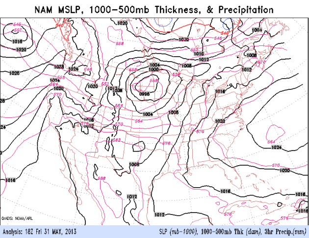
Looks Like A Saturday. NOAA's NAM model shows
showers pushing across Minnesota today, in response to a cold storm in
the upper atmosphere. An eastbound cool front sparks severe T-storms
across the Great Lakes, Ohio Valley and Mississippi Valley; dry weather
the rule out west.
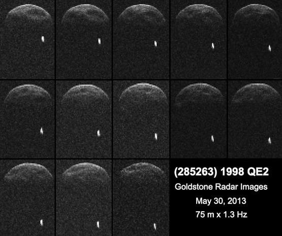
Don't Sweat The Showers. Yesterday's asteroid encounter with Earth was a little close for comfort; details from
NASA: "
Approaching
asteroid 1998 QE2 has a moon. Researchers found it in a sequence of
radar images obtained by the 70-meter Deep Space Network antenna at
Goldstone, Calif., on the evening of May 29th (May 30th Universal Time)
when the asteroid was about 6 million kilometers from Earth. The
preliminary estimate for the size of the asteroid's satellite is
approximately 600 meters wide. The asteroid itself is approximately 2.7
kilometers in diameter and has a rotation period of less than four
hours..."
Image credit above: "
First radar images of asteroid 1998
QE2 were obtained when the asteroid was about 3.75 million miles (6
million kilometers) from Earth. The radar collage covers a little bit
more than two hours." Image credit: NASA/JPL-Caltech/GSSR.
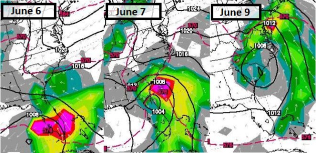
Extra-Tropical Storm Next Week? The ECMWF model
(WSI) continues to show soaking/flooding rains for Florida by the middle
of next week, a possible tropical depression or tropical storm pushing
heavy seas into the Carolinas, with a shield of heavy rain extending
into New York and Boston by next weekend.
As Hurricane Season Starts, U.S. Facing Heightened Risk.
More Americans living on or near the coast, coupled with a peak in the
natural hurricane cycle, and warmer than normal sea surface
temperatures, may set the stage for a very active hurricane season.
Climate Central meteorologist Andrew Freedman has the story; here's a clip: "...
Although the U.S. has seen its fair share of damaging storms in recent years, including Hurricane Sandy in 2013
(which technically was not a hurricane at landfall), the last major
hurricane to strike the U.S. was Hurricane Wilma in 2005. Scientists
contacted by Climate Central warned that in part because of the dearth
of major hurricanes, there may be a sense of “hurricane amnesia”
setting in among coastal residents — a potentially hazardous
combination for when the nation's luck runs out...."
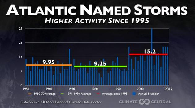
Graphic credit above: "
Graphic
showing that we've been in an active period of tropical cyclone
activity since 1995, where the average number of named tropical storms
has jumped significantly to 15.2 per year." Climate Central.
What Will Protect Us From The Next Surge? Coastal
residents have good reason to fear the storm surge. Wind speeds get a
lot of play in the media, but it's the storm surge that poses the
greatest risk of drowning out ahead of the eye. But as many as 1 in 4
deaths since 1950 have been associated with inland flooding, in some
cases days after a tropical storm or hurricane reaches land. Here's an
excerpt from
The Houston Chronicle: "
The
destruction wrought by Hurricane Ike in 2008 focused attention on the
need for storm surge protection for the Galveston-Houston area.
Researchers at Rice University
found that had Ike struck slightly farther west on Galveston Island,
it would have inundated scores of chemical plants and refineries. Ike
would have shut down the source of 40 percent of the nation's jet fuel,
27 percent of its gasoline and 42 percent of its chemical feed stocks.
To protect industry and residents from another Ike, or worse, several
storm-surge protection efforts are underway, including the well-known
Ike Dike concept..."
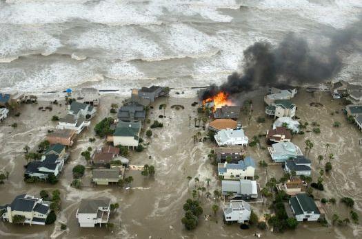
Photo credit above: "
A house is engulfed in flames as
water and waves inundate homes on Galveston Island as Hurricane Ike
approaches the coast Sept. 12, 2008." Photo: Smiley N. Pool, Staff / Houston Chronicle.
Floome Pocket Breathalyzer Calls A Cab When You've Had Enough.
Now here's a handy gadget (that plugs into your smartphone) for when
you're out on the town on a Saturday night, wondering if you just had
"one too many".
Gizmag.com has the story: "
If
you're plans for a night out on the town involve the consumption of
alcohol, it's probably a good idea to include strategies for getting
home safely when the night is over. The Floome pocket breathalyzer for
smartphones from Italian start-up 2045Tech is claimed to measure your
blood alcohol content (BAC) with the same level of accuracy as those
used by law enforcement. If the system decides that you're over the
limit, there's an option to call a taxi..."
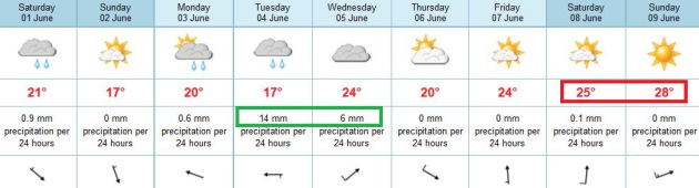
TODAY: Early sun, then clouds, showers. Cool for early June. Winds: NW 10-15. High: 67
SATURDAY NIGHT: Evening shower, then partial clearing late. Low: 48
SUNDAY: Cool sun, breezy. Better day. Winds: N 10. High: 66
MONDAY: Sunny start - clouds increase PM hours. Wake-up: 49. High: near 70
TUESDAY: Showers likely, possible thunder. Wake-up: 54. High: 65
WEDNESDAY: Wet start, slow PM clearing. Wake-up: 55. High: 70
THURSDAY: More sun, almost pleasant. Wake-up: 53. High: 71
FRIDAY: Mix of clouds and sun, springy. Wake-up: 51. High: 74
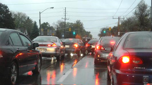
* photo above courtesy of WeatherNation TV meteorologist Todd Nelson.
Climate Stories....
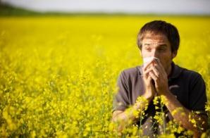
Climate Change Linked To More Pollen, Allergies, Asthma. Here's a clip from a story at
USA Today: "...
Climate
change might be partly to blame. Scientists see a link to carbon
dioxide, a heat-trapping greenhouse gas emitted by burning coal, oil
and other fossil fuels. Tests show that the more CO2 in the atmosphere,
the more plants generally grow and the more pollen they produce.
Though some plants grow more food or flowers as a result, more pollen
can spell trouble. Doctors say it's contributing to a rise in seasonal
hay fever and allergic asthma in the USA, where the pollen season has
lengthened up to 16 days since 1995. If carbon dioxide emissions
continue to increase, they expect allergic conditions probably will
worsen, adding to the discomfort of allergy suffers as well as swelling
U.S. health care costs..."
The American Party. Will it take a third political
party to address climate change, among other issues, a reaction to
political extremism on both sides of the aisle? Climate scientist James
Hansen believes it may be necessary in the years ahead; here's an
excerpt of his Op-Ed at
Huffington Post: "...
And
yet moderation is just what most Americans seem to want. In such case,
the fastest way to progress may be a 3rd party, a centrist party. It is
very possible that the United States is ready for a centrist American
Party. In 1992 Ross Perot garnered almost 20% of the votes for
President. At times he had led in the polls, but he damaged his
credibility in several ways, including his assertion that he had once
seen Martians on his front yard. Compared with 1992, a much larger
fraction of the people is fed up with the failures of both major
parties. If, following the mid-term elections of 2014, there is not a
strong indication of bipartisan progress, it may be time to consider
the possibility of launching a major centrist 3rd party effort, not
only for the Presidency but for Congress as well...."


No comments:
Post a Comment