Saturday, June 1, 2013

June-tember (stuck in a cool, wet, stormy rut - but for how long?)

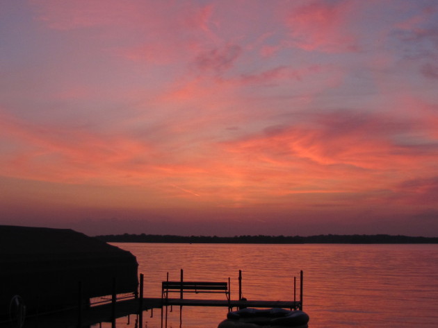
72 F. high Saturday in the Twin Cities.
74 F. average high on June 1.
72 F. high on June 1, 2012.

.06" rain fell yesterday from PM instability showers.
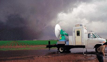


Tornado Chasing

It sounds like a hobby for the mentally deranged. "Hey, let's try to intercept a tornado!" Oklahoma is ground zero of Tornado Alley, no more so than the last couple of weeks, with a rash of deadly twisters.

The movie "Twister" made tornado-chasing cool: research meteorologists surrounding a tornadic storm with portable Doppler and weather balloons, trying to understand what makes these fierce storms tick. Then amateur chasers realized they could make a few bucks selling tornado video to local TV stations.

Now on any given day thousands of chasers are stalking thunderheads, in search of the money shot - or a cheap adrenaline thrill. The result? Rush hour on 2-lane dirt roads; traffic jams that can make it hard to escape the path of an erratic tornado. Some chasers were injured Friday night outside Oklahoma City. Me? I'm more afraid of fast-driving chasers than the actual tornado itself.
Sometimes you chase tornadoes - other times the tornado chases you.

We salvage cool sun today; the next storm kicking up rain late Monday into Wednesday, more rain & storms next weekend.

The core of the storm track is howling directly overhead, meaning frequent fronts, ample rains, a few bouts of severe weather and little risk of overheating anytime soon.

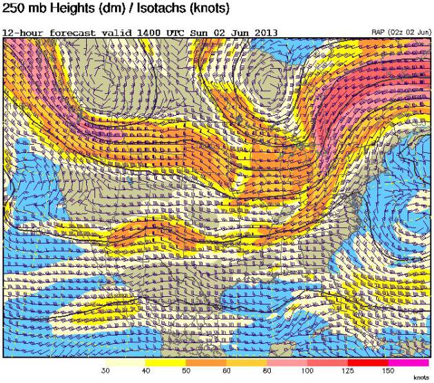
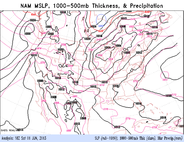
A (Consistent) Southward Shift To The Jet Stream. Why has it been so cool and wet in recent months? The jet is 500-800 miles farther south than usual for early June, a trend which has been apparent since March. The core of steering levels winds is howing almost directly over Minnesota, meaning frequent storms and cool frontal passages. Why is the jet so far south? Good question, and not a lot of great answers. One theory: record melting of Greenland and Arctic ice in late 2012 threw the northern branch of the jet stream out of alignment. A bubble of warm high pressure set up near the North Pole, displacing the cold "polar vortex" farther south than usual, setting the stage for chillier, stormier weather from North America to Europe and Asia. And here's the thing: I don't see this pattern breaking down anytime soon. Odds favor cooler, wetter, stormier weather in June, possibly beyond. Too early to say with confidence, but steering winds are definitely stuck in a persistent, long-term rut.

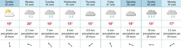
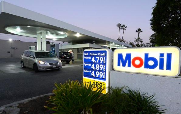
When In Doubt - Predict Rain. The ECMWF (European) model has only one day this week with no rain - today. The best chance of showery rains: Tuesday and Wednesday, again late Friday into Sunday. Highs range from 60s to 70s. A/C optional until further notice.

Status Quo. 
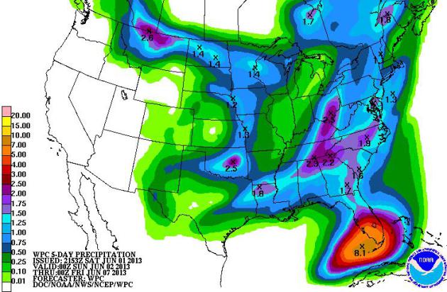
NOAA NCEP's 5-Day Rainfall Outlook (QPC) prints out some 5-8" amounts for south Florida as a tropical system lifts north out of the Gulf of Mexico. The Middle Mississippi Valley gets a brief break, bone-dry weather west of the Rockies.

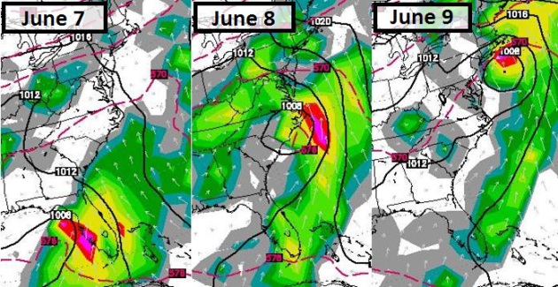
Wet, Active Pattern. At least east of the Rockies a southward jog to the jet stream will squeeze out more showers and T-storms. Oklahoma sees a break in severe thunderstorm activity until the latter half of next week. Keep an eye on the eastern Gulf of Mexico for possible tropical depression or storm development within 5-6 days. NAM loop: NOAA.


Another Tornado Emergency. Here's a RadarScope image showing velocity fields at the height of yesterday's rain-wrapped (multi-vortex) tornado that hit the western and southern suburbs of Oklahoma City. It's been a terrifying month for local residents, light to moderate damage reported again in Moore, hit so hard by an EF-5 early last week. Thanks to WeatherNation TV meteorologist Susie Moore for the image.

The Dark Side of Tornado Chasing. Sometimes you chase the tornado - sometimes the tornado chases you. I'm relieved Mike Bettes from The Weather Channel is OK, reports of bumps, bruises and cracked ribs as the vehicle was rolled during yesterday's freak tornado outbreak. This twister was erratic, a "right-turner" - it veered to the right, catching many storm chasers offguard. Yesterday there were hundreds, possibly thousands of tornado chasers converging on Oklahoma City, professionals and amateurs. One of these days there's going to be a terrible tragedy among the chaser/spotter community. Yesterday we got a glimpse of how things can go south (literally) in a hurry.

Tornado Distribution: 2001 - 2010. Here's an interesting map from NOAA, showing an apparent eastward shift in Tornado Alley. South Carolina and Alabama saw as many tornadoes per 10,000 square miles as Iowa and Oklahoma. Peak states for tornado touchdowns last decade: Kansas and Mississippi.

A May To Remember (Or Promptly Forget). Amen. Here's an excerpt from this week's edition of WeatherTalk, courtesy of Dr. Mark Seeley: "...Combined with the precipitation for March and April, the overall spring season (March-May) was the wettest in history for southeastern Minnesota, saturating soils, and putting streams and rivers near bank full. Statewide this spring is likely to end up among the top ten wettest in history. The snow storm over the first few days of May established some records in southeastern Minnesota as well. Dodge Center reported a statewide daily record snowfall for May with 15.4 inches on the 2nd. Observer reports for snow totals ranged from 9 inches (Albert Lea) to 17.3 inches (Ellendale) across many areas of southern Minnesota in one of the snowiest Mays in state history..."

Don't Sweat The Showers. Yesterday's asteroid encounter with Earth was a little close for comfort; details from NASA: "Approaching asteroid 1998 QE2 has a moon. Researchers found it in a sequence of radar images obtained by the 70-meter Deep Space Network antenna at Goldstone, Calif., on the evening of May 29th (May 30th Universal Time) when the asteroid was about 6 million kilometers from Earth. The preliminary estimate for the size of the asteroid's satellite is approximately 600 meters wide. The asteroid itself is approximately 2.7 kilometers in diameter and has a rotation period of less than four hours..."
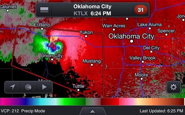
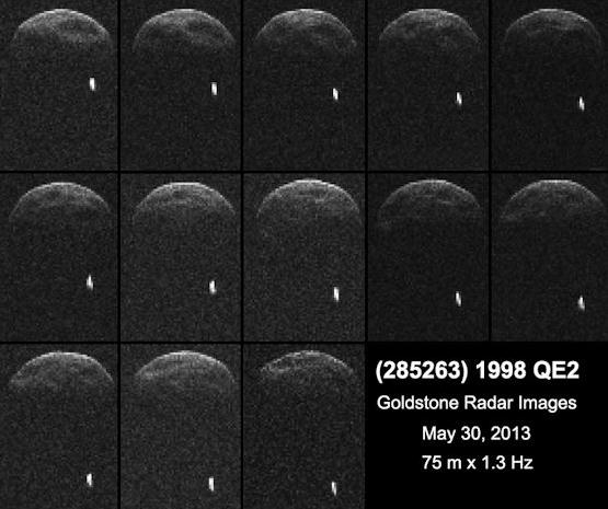
Image credit above: "First radar images of asteroid 1998 QE2 were obtained when the asteroid was about 3.75 million miles (6 million kilometers) from Earth. The radar collage covers a little bit more than two hours."  Image credit: NASA/JPL-Caltech/GSSR.

Extra-Tropical Storm Next Week? The latest ECMWF model (WSI) continues to show soaking/flooding rains for Florida by the middle and end of next week, a possible tropical depression or even a weak tropical storm pushing heavy seas into the Carolinas, with a shield of heavy rain extending into New York and Boston by next weekend.


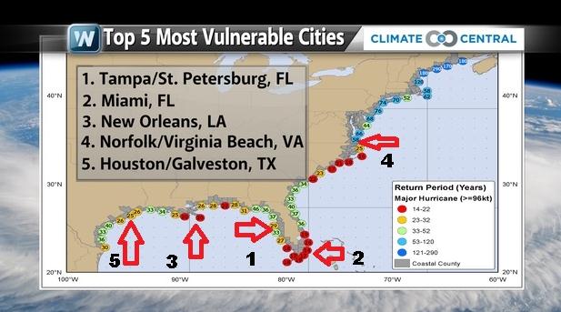
America's Most Vulnerable Hurricane Metropolitan Areas. Tampa/St. Pete tops the list, Miami, New Orleans, Virginia's Tidewater region and Houston/Galveston in the Top 5. Source: Climate Central.


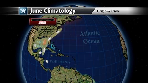
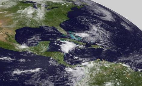
June Hurricane Climatology. Tropical storms and hurricanes are most likely to form in the eastern Gulf of Mexico in June, according to NHC records. Image: WeatherNation TV.

As Hurricane Season Starts, U.S. Facing Heightened Risk. More Americans living on or near the coast, coupled with a peak in the natural hurricane cycle, and warmer than normal sea surface temperatures, may set the stage for a very active hurricane season. Climate Central meteorologist Andrew Freedman has the story; here's a clip: "...Although the U.S. has seen its fair share of damaging storms in recent years, including Hurricane Sandy in 2013 (which technically was not a hurricane at landfall), the last major hurricane to strike the U.S. was Hurricane Wilma in 2005. Scientists contacted by Climate Central warned that in part because of the dearth of major hurricanes, there may be a sense of “hurricane amnesia” setting in among coastal residents — a potentially hazardous combination for when the nation's luck runs out...."

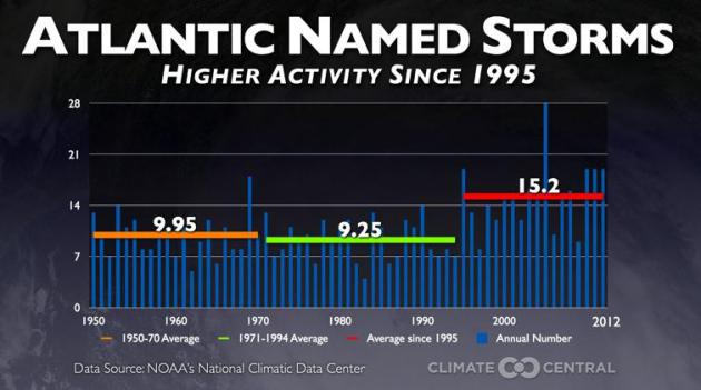
Graphic credit above: "Graphic showing that we've been in an active period of tropical cyclone activity since 1995, where the average number of named tropical storms has jumped significantly to 15.2 per year." Climate Central.

What Will Protect Us From The Next Surge? Coastal residents have good reason to fear the storm surge. Wind speeds get a lot of play in the media, but it's the storm surge that poses the greatest risk of drowning out ahead of the eye. But as many as 1 in 4 deaths since 1950 have been associated with inland flooding, in some cases days after a tropical storm or hurricane reaches land. Here's an excerpt from The Houston Chronicle: "The destruction wrought by Hurricane Ike in 2008 focused attention on the need for storm surge protection for the Galveston-Houston area. Researchers at Rice University found that had Ike struck slightly farther west on Galveston Island, it would have inundated scores of chemical plants and refineries. Ike would have shut down the source of 40 percent of the nation's jet fuel, 27 percent of its gasoline and 42 percent of its chemical feed stocks. To protect industry and residents from another Ike, or worse, several storm-surge protection efforts are underway, including the well-known Ike Dike concept..."

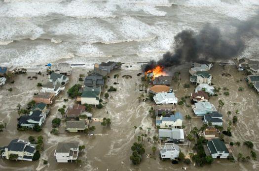
Photo credit above: "A house is engulfed in flames as water and waves inundate homes on Galveston Island as Hurricane Ike approaches the coast Sept. 12, 2008." Photo: Smiley N. Pool, Staff / Houston Chronicle.

You Think It's Wet Here? Yes, it is soggy, but just south of the border they're bailing out from the wettest spring on record across Iowa. Graphic courtesy of WeatherNation TV.


NOAA Satellite May Be Back Online Soon, Official Says. Climate Central has the story - here's an excerpt: "A vital weather satellite that blinked out on May 22 may be back in service as early as June 5, according to an official at the National Oceanic and Atmospheric Administration (NOAA). The satellite, known as GOES-13, suffered from an unexplained change in its orientation toward the Earth — what NOAA calls an “attitude disturbance” — that caused its instruments to shut down automatically. So far, engineers working to restart the satellite have not found any signs of damage, nor have they found an explanation for the satellite’s sudden shift..."

Image credit above: NOAA. "GOES East image taken on May 31, 2013 by the backup satellite, GOES-14."


TODAYMix of clouds & sun, cool breeze. Winds: NW 10+ High: 65

SUNDAY NIGHTMostly clear and cool. Low: 47

MONDAY: Sunny start, clouds increase PM hours. Shower possible Monday night. High: 68

TUESDAY: Heavier showers expected. Wake-up: 54. High: 64

WEDNESDAY: Showers taper, still damp. Wake-up: 55. High: 67

THURSDAY: Fleeting sunshine, take a photo. Wake-up: 53. High: near 70

FRIDAY: Fading sun, showers late. Wake-up: 56. High: 72

SATURDAYWhat a shock: more rain, T-storms. Wake-up: 58. High: 74


Climate Stories....


The Climate Change Guilt Trip. It's easy to get depressed some days, especially when you second-guess efforts to reduce your carbon footprint. Here's an excerpt of an Op-Ed at The Los Angeles Times"...Of course, it wasn't really about me. What my friend expressed was climate guilt, a feeling that many of us who care about environmental issues experience every day. I am not immune. We feel guilty about driving cars and watching TV and turning on lights, as if that makes us personally responsible for this gigantic threat that looms over us. For years, caring governments and thoughtful corporations have communicated the idea that we're all in this together, that if we each just do our bit we can solve this global warming mess. Duke Energy, a utility company that depends heavily on coal, points out that "saving the environment can be as easy as changing a light bulb." It's a gentle, brotherly tone. But there's something in the subtext here too — a warning: "Let he who is without sin cast the first stone..."

Photo credit above: "Oil companies have made up the most powerful industry on Earth for the last 50 years." (Michael Nelson / EPA)

Climate Change Linked To More Pollen, Allergies, Asthma. Here's a clip from a story at USA Today: "...Climate change might be partly to blame. Scientists see a link to carbon dioxide, a heat-trapping greenhouse gas emitted by burning coal, oil and other fossil fuels. Tests show that the more CO2 in the atmosphere, the more plants generally grow and the more pollen they produce. Though some plants grow more food or flowers as a result, more pollen can spell trouble. Doctors say it's contributing to a rise in seasonal hay fever and allergic asthma in the USA, where the pollen season has lengthened up to 16 days since 1995. If carbon dioxide emissions continue to increase, they expect allergic conditions probably will worsen, adding to the discomfort of allergy suffers as well as swelling U.S. health care costs..."

The American Party. Will it take a third political party to address climate change, among other issues, a reaction to political extremism on both sides of the aisle? Climate scientist James Hansen believes it may be necessary in the years ahead; here's an excerpt of his Op-Ed at Huffington Post: "...And yet moderation is just what most Americans seem to want. In such case, the fastest way to progress may be a 3rd party, a centrist party. It is very possible that the United States is ready for a centrist American Party. In 1992 Ross Perot garnered almost 20% of the votes for President. At times he had led in the polls, but he damaged his credibility in several ways, including his assertion that he had once seen Martians on his front yard. Compared with 1992, a much larger fraction of the people is fed up with the failures of both major parties. If, following the mid-term elections of 2014, there is not a strong indication of bipartisan progress, it may be time to consider the possibility of launching a major centrist 3rd party effort, not only for the Presidency but for Congress as well...."

No comments:

Post a Comment