76 F. high in the Twin Cities Wednesday.
78 F. average high on June 12.
69 F. high on June 12, 2012.
.59" rain fell yesterday in the Twin Cities.
Dry today with plenty of sun; highs close to average for June 13.
Spotty T-showers possible late Friday into Saturday; Sunday probably the nicer day of the weekend.
Head-Shaking Weather
"Paul, Minnesota Nice just got tossed out the
nearest window this summer". Locals are fuming. I don't miss the heat,
but a little sun would be nice as I cut back the vines in my backyard
jungle.
I gave a talk to the Minnesota Emergency
Managers Association yesterday. A women came up afterwards, a bit dazed.
"We had brush fires up north, but couldn't get at water because the
lakes were frozen. We had to pull snowplows off MSP's runways in early
May because of lightning! You don't have to tell me the weather is
getting weirder over time".
Two things on my mind today: if your county is
ever under a PDS (Particularly Dangerous Situation) Tornado Watch pay
extra-close attention: the risk of large tornadoes is greater. If a
confirmed (large) tornado is moving into an urban area the NWS may issue
a "Tornado Emergency". One notch more urgent than a regular Tornado
Warning.
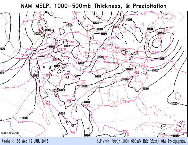
Expect a volatile, partly-severe summer for Minnesota as the jet stream howls overhead.
The sun comes out today; a few spotty T-storms
late Friday into midday Saturday. Sunday looks like the sunnier day of
the weekend; highs topping 80. A kink in the jet stream forces hot air
north next week; I wouldn't be surprised to see a few sizzling 90s late
next week.
Lovely.
Less Rain - More Warmth. Everything is taking longer
this year. Early May felt more like late March, we may not sample
typical June weather until July. I'm seeing a 3-6 week lag across the
board. But the jet is showing signs of (slowly) migrating north over
time. That should be good for low 80s Sunday, a stretch of mid 80s next
week, maybe a few 90s late next week. ECMWF (European) forecast highs
above in Celsius.
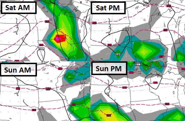
Weekend Preview. ECMWF guidance (courtesy of WSI)
shows nocturnal T-storms Friday night, spilling over into a portion of
Saturday morning, with patchy clouds and (isolated) late PM thunder,
best chance near the Iowa border. Sunday looks better, drier, with a few
late PM instability showers and T-showers over northern Minnesota, but
dry weather across most of Minnesota most of the day. Fingers crossed
for a better weekend.
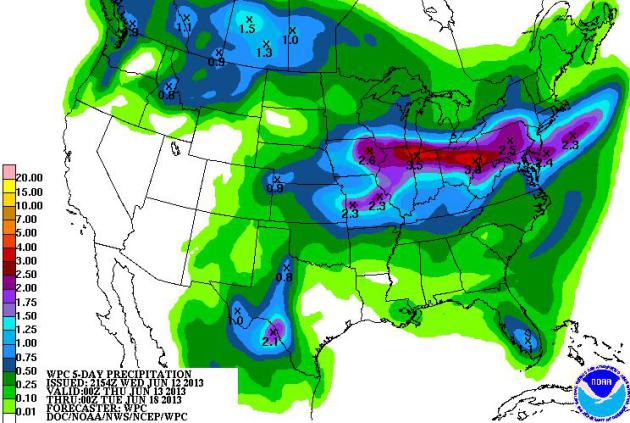
Shifting Seasons. Canadian air is draining unusually
far south, considering we're a little more than a WEEK from the Summer
Solstice. The resulting atmospheric tug-of-war is playing out over the
Great Lakes and New England, where some 2-4" rainfall amounts are
predicted by next Tuesday, according to NOAA.
More Like Mid-May. The main
branch of the jet stream is still pushing unusually far south - one
major reason why we're seeing a big uptick in severe storms and
tornadoes; the combination of June-like heat and humidity over the
southern states, coupled with an energetic, early-May-like jet stream
pattern dipping south, creating the instability and wind shear necessary
for severe storm outbreaks. Today we watch the Mid Atlantic region for
damaging winds and a few tornadoes. The next system kicks up a few
showers Friday into early Saturday over Minnesota and the Upper Midwest,
but much of the weekend should be dry from the Dakotas into Minnesota
and Wisconsin, a better chance of T-storms Omaha to Des Moines and
Chicago.
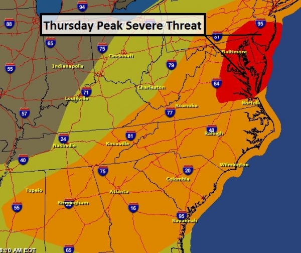
Thursday Severe Threat.
Tomorrow atmospheric dynamics shift east, with a potential for damaging
straight-line winds, even a few large tornadoes, from near Richmond to
Washington D.C., Baltimore, Annapolis, the Delaware Valley and south
Jersey. A slight risk of severe storms (and isolated tornadoes) extends
from Birmingham and Atlanta to New York.
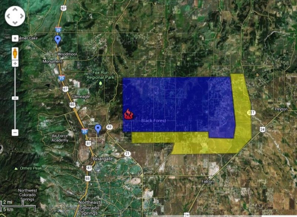
Black Forest Blaze. The
wildfire burning just north/east of Colorado Springs continues to grow
in size and intensity, record heat and gusty winds fanning flames and
complicating rescue operations on the scene. Over 6,000 people have been
evacuated from the zone - 80 to 100 homes lost, with over 8,000 acres
burned. The evacuation order covers roughly 24,000 acres or 48 square
miles. With 100-degree heat and winds gusting to 40 mph
conditions are very similar to last June's Waldo Canyon Fire, which destroyed 300 homes in the Colorado Springs area.
Click here for more information.
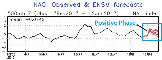
Pattern Shift? It's a little early to break out the
bubbly and party hats, but there's growing evidence that the NAO (North
Atlantic Oscillation) may be going into a positive phase, meaning
stronger west to east (zonal) winds and warmer temperatures over much of
the USA. Graph above showing NAO history since mid-February, and
forecast for the latter half of June.


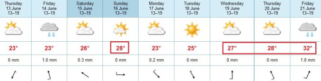
TODAY: Plenty of sun, quite pleasant. Winds: NE 10. High: 76
THURSDAY NIGHT: Clear. Low: 58
FRIDAY: AM sun, late-day T-storm. High: 77
SATURDAY: Some sun, stray T-shower possible. Wake-up: 63. High: 79
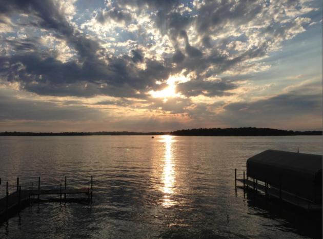
SUNDAY: Partly sunny, better lake day. Wake-up: 65. High: 82
MONDAY: More clouds than sun, cooler. Wake-up: 63. High: 78
TUESDAY: Warm sunshine, feels like June. Wake-up: 61. High: 82
WEDNESDAY: Sticky sun, dew points: 65-70. Wake-up: 62. High: 84
Climate Stories...
Disease Outbreak Threatens The Future Of Good Coffee.
Please God, not the coffee. Now we have to worry about "coffee rust", a
fungus that is more prevalent in a warmer, wetter climate? Here's an
excerpt from
wired.com: "...
Nobody
knows precisely why the outbreak reached such extraordinary levels
this year, though several factors are implicated. The most prominent is
climate: In the past, environmental conditions at high Central
American altitudes were not especially conducive to the fungus, which
requires warm, humid air to thrive, said coffee rust specialist Cathy
Aime of Purdue University. Since the mid-20th century, though, weather patterns in Central America and northern South America have
shifted. Average temperatures are warmer across the region, with
extremes of both heat and cold becoming more pronounced; so are extreme
rainfall events..."
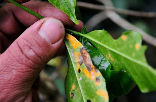
Photo credit above: "
A rust-blighted leaf on a farm in Colombia."
Image: International Center for Tropical Agriculture/Flickr.
Why Greenland's Darkening Ice Has Become A Hot Topic In Climate Science. The Guardian has the story - here's a clip: "
Last July, a record melting occurred on the Greenland ice sheet. Even in some of the highest and coldest areas, field parties observed
rainfall with air temperatures several degrees above the freezing
point. A month before, it was as though Greenland expert Jason Box had a
crystal ball; he predicted this complete surface melting in a scientific publication. Box's research then got broader public visibility after climate activist and writer Bill McKibben covered it in Rolling Stone magazine.
The basic premise of Box's study was that observations reveal a
progressive darkening of Greenland ice. Darkening causes the white snow
surface to absorb more sunlight which in turn increases melting. Given
that this process is likely to continue, the impact on Greenland melt,
and subsequent sea level rise, will be profound..."
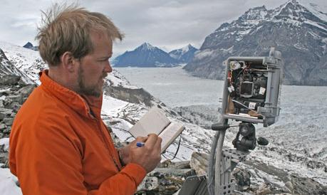
Photo credit above: "
Climate scientist Jason Box during an expedition in Greenland in July 2008." Photograph: Byrd Polar Research Center
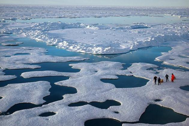
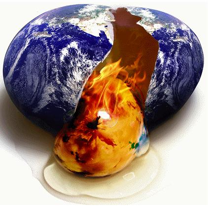
NASA Warns Arctic Thaw Could Have Huge Impact On Global Warming.
Think we're in uncharted waters now, with increasingly erratic,
head-shaking weather patterns? Wait until most of the ice is gone in the
Arctic and permafrost melts at high latitudes worldwide. Then things
will really start to get interesting. Here's an excerpt from
The Verge: "The Arctic's permafrost soils
have NASA worried.
Scientists monitoring carbon levels in the top layers of Arctic soils
have identified huge deposits that, if thawed sufficiently, could upset
its carbon balance and magnify the impacts of global warming. The
agency estimates that the Arctic's permafrost soils store as much as
1,850 petagrams (one petagram equals 1 billion metric tons), comprising
around half of all the carbon stored in Earth's soils — most of it
lying within 3 meters of the surface.
TV Weathermen And Climate Scientists Kiss And Make Up.
Well, not quite, but manic weather is accomplishing what climate
science couldn't - convince a critical mass of TV meteorologists that
something is going on - something has changed. Here's an excerpt from
Mother Jones: "...
Ostro
believes that clmate change is increasing the atmosphere's overall
thickness and thereby forcing weather patterns to stay in place for
longer - with sometimes devastating results. Francis, meanwhile, argues
that the dramatic warming of the Arctic is, in turn, slowing down the
hemisphere-sized loopings of the jet stream - with very similar
consequences. And there are other signs that relations between climate
scientists and weather forecasters are improving - signs that go
considerably beyond the scientific mutual admiration society that is
Francis and Ostro..."
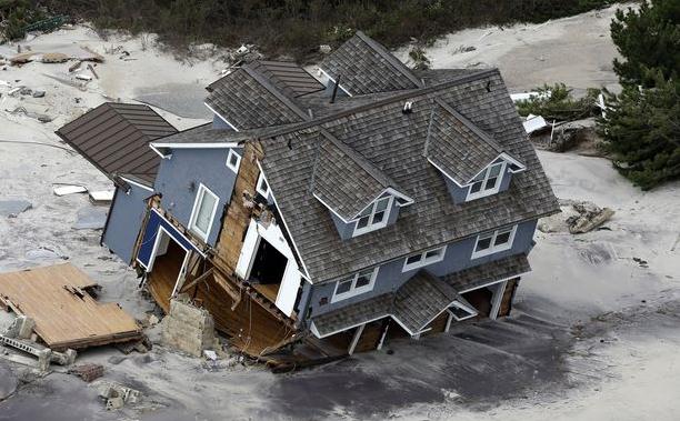
Bloomberg's Race To Protect NYC From Climate Change. Here's a snippet of an Op-Ed at
The Washington Post: "...
By
mid-century, up to a quarter of all New York City’s land area, where
800,000 residents live today, will be in the flood plain,” he said, and
“40 miles of our waterfront could see flooding on a regular basis just
during normal high tides.” We no longer have the luxury of ideological
debate, he said. “The bottom line is we can’t run the risk.” Andrew Light, a global-warming specialist at the liberal Center for American Progress,
explained to me the recent shift toward efforts to adapt to climate
change rather than merely seeking to prevent it. “We’re starting to see
very strong evidence of climate-related extreme events happening sooner
than we thought with only a 1-degree [Celsius] rise in temperature,”
he said, “and a more refined science saying now that we will more than
likely edge up to or cross the 2-degree threshold...” (photo: AP).
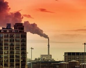
Greenhouse Gases Nearing Highly Dangerous Levels, Study Finds. Here's a clip from a story at
The Chicago Tribune: "...
The
IEA report, Redrawing the Energy-Climate Map, says carbon dioxide
emissions grew at a rate of 1.4% in 2012, releasing a record 31.6
gigatons into the atmosphere. On this current path, the world’s average
temperatures are on track to increase between 3.6 degrees Celsius to
5.3 degrees Celsius, or 6.48 degrees Fahrenheit to 9.54 degrees
Fahrenheit, by the end of the century, said the IEA, an independent
research group established by the world’s most industrialized nations.
“Climate change has quite frankly slipped to the back burner of policy
priorities,” said www.wired.com/wiredscience/2013/06/coffee-rust-epidemic/all/IEA Executive Director Maria van der Hoeven. “But the problem is not going away — quite the opposite...”
Waiting On A New Climate Deal "Will Set World On A Path to 5C Warming". Here's an excerpt from an Op-Ed at the International Energy Agency's Chief Economist in
The Guardian: "...
The world cannot afford to wait for a new global climate change
agreement to come into force in 2020, because doing so will mean an
end to hopes of limiting global warming to moderate levels, one of the
world's foremost authorities on energy
has warned. Carbon dioxide emissions from energy rose by 1.4% in 2012
to a record high of more than 31bn tonnes, according to a report from the International Energy Agency on Monday, driven in part by a striking 6% rise in emissions from Japan following its phase-out of nuclear power and continuing growth in emissions from China.
Fatih Birol, chief economist at the IEA, and one of the world's most
respected energy experts, told the Guardian that greenhouse gas
emissions were continuing to rise so fast that pinning hopes on a
replacement for the Kyoto protocol would set the world on a path to 5C
of warming, which would be catastrophic..."


No comments:
Post a Comment