79 F. high Tuesday in the Twin Cities.
78 F. average high for June 11.
74 F. high on June 11, 2012.
Best chance of showers and T-storms today south of MSP
Dry this afternoon into at least midday Friday.
Over The Edge
"Paul, my parents came back from Arizona in
April, thinking they were home free. Now they're threatening to never
return north to the Land of 10,000 Weather Disappointments!" I'm hearing
this a lot. People fed up by our 7-month winter, deflated by our cool,
wet (late) spring and no-show summer. Will there be a few thousand
additional snowbirds come December? Probably.
The reality: most of our winters since the late
90s have been pretty easy, but every now and then Mother Nature spanks
us pretty hard.
A cool bias is keeping the most severe T-storms
just to our south today; we'll get grazed by a few morning showers -
skies brighten this afternoon, and Thursday will restore your faith in
June. The next unstable swirl of cold air aloft sparks random T-storms
late Friday into Sunday evening.
It won't rain all weekend, in fact most of the
time should be dry with highs in the 70s. A string of 80s return next
week. If this keeps up June will arrive..sometime in July.
Try to keep some perspective: Arizona is an
oven. Florida's lovely, except for Texas-size storms with names.
California's a relief, when the ground isn't shaking violently. 2013 has
brought annoying weather. But it could always be worse.
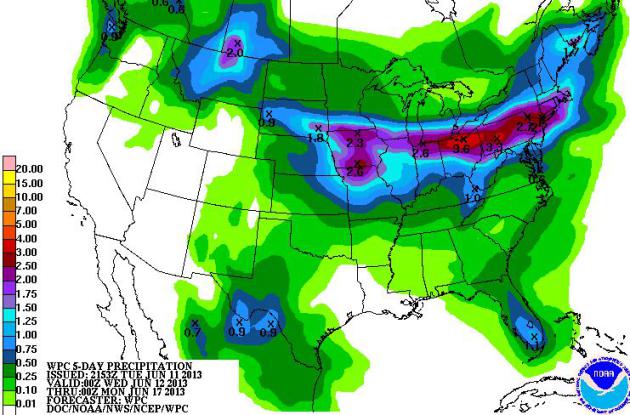
5 Day Rainfall. Conditions are
ripe for severe (training) thunderstorms - passing over the same
counties of the Midwest and Ohio Valley into the Northeast by Thursday
and Friday. Too much water east of the Mississippi, while wildfires grow
in size and intensity from Colorado into New Mexico.
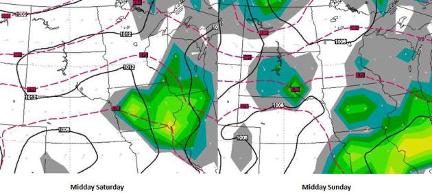
Weekend Preview. ECMWF model
guidance (WSI) shows morning showers and T-storms Saturday giving way to
partial clearing by midday and afternoon. A dry start Sunday may give
way to a few instability T-showers by midday and afternoon Sunday.
Trying to time weekend T-storms, 3-4 days in advance, is a fool's
errand.
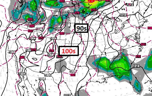
Trending Warmer - Slowly But Slowly.
No heat spikes until the end of next week, when highs may surge into
the 90s. Until then a southerly detour of the jet stream will keep highs
in the 70s and 80s. ECMWF forecast highs above in Celsius.
Heat Spike Late Next Week? Denver
saw 100 F. Tuesday, the earliest 100-degree high on record. Intense
heat is likely from the Central Plains into the Rockies and Southwest
for the next 1-2 weeks, ECMWF data hinting at 90s surging northward next
week. The way this year is going I'm not holding my breath.
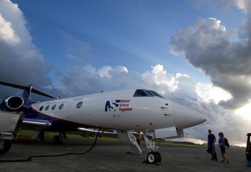
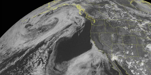
Storm Chasing From The Sky. Now this is how to storm
chase - from an altitude of 40,000 feet. Within a few years NOAA may be
sending jet aircraft into the vicinity of supercell thunderstorms
capable of major tornadoes, similar to how they send 4 engine propeller
"Hurricane Hunter" aircraft into tropical storms and hurricanes today.
USA Today has the story; here's an excerpt: "...
Early
morning flights aboard the Gulfstream V jet have sampled the pre-storm
atmosphere across several states in the Intermountain West and the
Plains, cruising at 40,000 feet in altitude for up to six hours. The
scientists have been looking for signs of bad weather that could be
hiding far above the clouds. Specifically, the project is looking to
better the weather forecasts that fall between two types of long-range
alerts:
• Long term projections, known as convective outlooks, which
show the risk of severe weather up to eight days in advance across
large parts of the country; and...
• Tornado and severe thunderstorm watches, which are issued up to eight hours in advance for state-sized areas..."
Photo credit above: "
The Gulfstream V is readied to take
off on a mission to study Tropical Storm Gaston in 2010. This is the
same aircraft used in the MPEX project this spring.
" (Photo: NCAR).
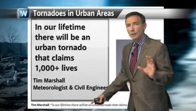
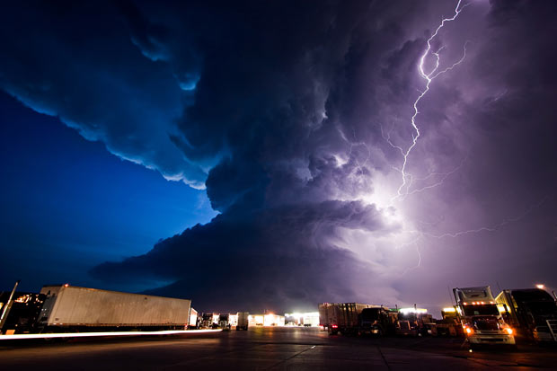
Our Worst Fear: A Large, Urban Tornado. Downtowns
have been struck in recent years, including Nashville, Salt Lake City
and Miami. An EF-4 tornado hit La Plata, Maryland, tracking about 30
miles south of the White House in D.C. There's no reason why an EF-4 or
EF-5 couldn't strike a major downtown or close-in suburb. We've been
relatively lucky over the years. But as suburban sprawl continues, the
statistical odds of injury-producing tornadoes increases too, and at
least one structural engineer and meteorologist is forecasting a day of
reckoning in our lifetime. Details in today's edition of
Climate Matters.
I've also included footage of the recent waterspout/tornado in
Baltimore, and new, remarkable police dashcam-video of the developing
EF-5 that hit Newcastle, then Moore, Oklahoma on May 20.
Deadly Oklahoma Tornado Upgraded To Widest On Record, Rare EF-5 Twister. Here's an excerpt from the AP and the Seattle Times article that resonated: "...Like
many Midwestern cities, the Oklahoma City metropolitan area continues
to expand in the suburbs, but the rapid growth hasn’t quite reached as
far west as where Friday’s tornado tracked. William Hooke, a senior
policy fellow of the American Meteorological Society, said the
continued growth of cities in tornado-prone areas makes it only a
matter of time before another monstrous twister hits a heavily
populated area. “You dodged a bullet,” Hooke said. “You lay that path
over Oklahoma City, and you have devastation of biblical proportions."
Photo credit above: Alonzo Adams / The Associated Press. "
The
National Weather Service has upgraded the deadly tornado that struck
near Oklahoma City last week to a top-of-the-scale EF5 twister, which
packed winds reaching 295 mph. The weather service also says the
twister's 2.6-mile width is the widest ever recorded."
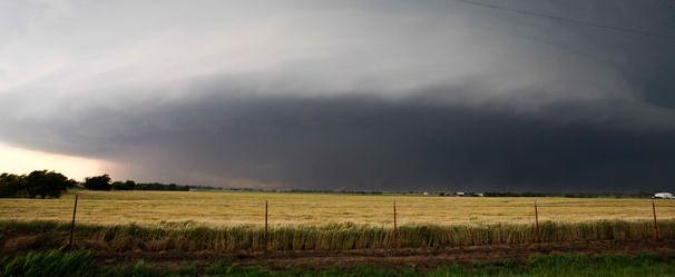
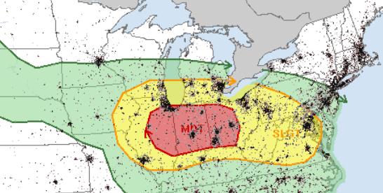
Enhanced Ohio Valley Tornado Risk Wednesday. All
the ingredients are present for a few larger, more violent EF-2+
tornadoes Wednesday afternoon, from Chicago to Indianapolis, South Bend,
Cincinnati, Dayton and Columbus. I expect SPC to issue Tornado Watches
for portions of the red-shaded area by 2 or 3 pm tomorrow, with a 1 in
3 chance of a PDS (Particularly Dangerous Situation) Tornado Watch,
implying a high risk of damaging tornadoes. We may also see an MCS or
even a derecho capable of violent straight-line winds.
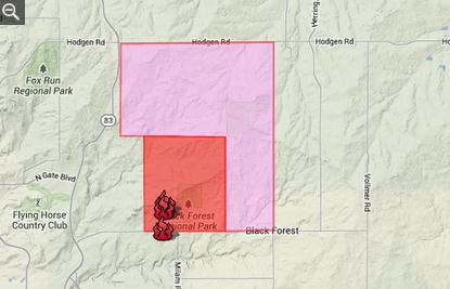
Black Forest Blaze Near Colorado Springs, Colorado.
Record heat Tuesday (highs topping 100F) coupled with high winds and
tinder-dry conditions have resulted in a significant blaze outside
Colorado Springs. At least 6 homes have been consumed by flames, dozens
more evacuated. Thousands of local Black Forest residents have been
evacuated, as a precaution.
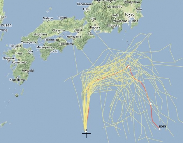
Tropical Storm Yagi. Yagi is a Tropical Storm, with
sustained winds of 46 mph, gusts to 48 mph. The storm is pushing into
cooler Pacific Ocean water and greater low-level wind shear, and it has
shown weakening over the last 24 hours. It is not expected to achieve
hurricane/cyclone status off the coast of Japan, but rather do a U-Turn
and weaken to depression status. But the storm is tracking
uncomfortably close to Tokyo - we'll continue to watch it carefully.
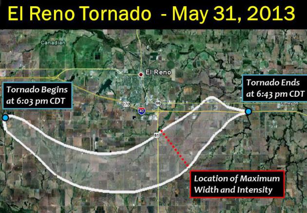
El Reno Tornado Had Rare Anticyclonic Companion. When tornadoes get that big all kinds of strange things can happen;
LiveScience has the story - here's a clip: "
As if the massive EF5 tornado that hit El Reno, Okla., last week weren't already noteworthy — it ranks as the widest tornado on record,
at 2.6 miles (4.2 kilometers) across — it was also accompanied by a
rare anticyclone twister that formed 3 miles (4.8 km) to the southeast,
reports the Washington Post's Capital Weather Gang blog.
Anticyclonic tornadoes are ones that spin clockwise instead of the
usual counterclockwise (in the Northern Hemisphere, that is). These
usually only form as waterspouts or twisters generated by non-supercell
storms (those that don't have a rotating updraft), the Capital Weather
Gang notes..."
Image credit above: "
The path of the tornado that hit near
El Reno, Okla., a suburb of Oklahoma City, on May 31, 2013. The tornado
was judged by researchers to have been an EF5 at its peak and to have
reached 2.6 miles wide at its peak (marked on the map)." Credit: NWS/NOAA.
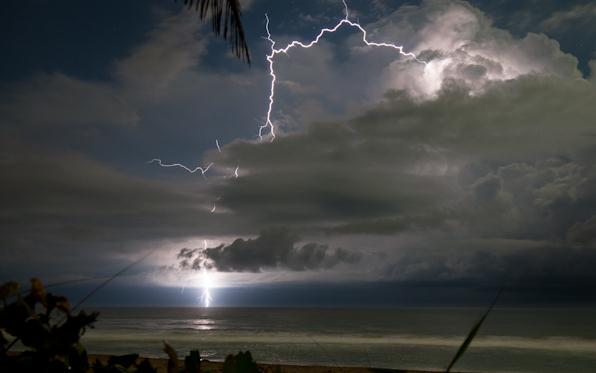
Could Lightning Provide Earlier Tornado Warnings? Here is an avenue of research that holds tremendous potential to lengthen lead times for severe storms, including tornadoes.
Scientific American has the story - here's a clip: "...
On
the day the devastating tornado hit Moore, Okla., Robert Marshall sat
glued to the news, watching images of the deadly twister on CNN while
he also monitored it on his computer. Marshall, the energetic CEO of
Earth Networks, a company that owns and operates an enormous network of
weather sensors, was looking for one thing in particular: lightning.
But he didn't see it. "These tornadoes from a couple weeks ago were
probably the most videotaped tornadoes in history. If you just watched
the video, there's almost no lightning," Marshall said. Visible
lightning, that is. In fact, as Marshall explained, there actually was
lightning, a whole lot of it, in the storm that caused the Moore
tornado. It's just that most of it didn't hit the ground and was thus
unseen by humans..."
Storm Chasing Critical, Profitable, And Dangerous. Yes to all three. Here's a portion of a story from AP and
The Grand Forks Herald: "...
Professors
at the University of Oklahoma's School of Meteorology strongly
discourage their students from storm chasing and rarely bring them into
the field for research unless it's part of a well-planned, coordinated
project. "I can tell you that from a university perspective, we do not
condone storm chasing at all. It's not something we teach in classes,"
said Melissa Bird, spokeswoman for OU's College of Atmospheric and
Geographic Sciences. "It's dangerous, and students are not considered
weather experts." In the end, meteorologists, like Armstrong, believe
storm trackers play an important role in keeping the public safe. "There
are aspects of it where storm chasers and storm trackers are always
going to play a vital role in the warning process," Armstrong said. "But
it is inherently dangerous to be around these storms..."
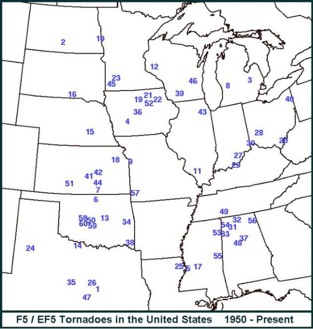
EF5 Tornadoes Since 1950.
NOAA SPC has an online graphic showing the location (and year) of every F5 and EF5 since 1950.
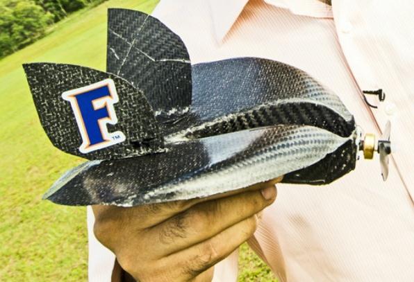
How Swarming Drones Can Explore a Hurricane. It just dawned on me - I need a drone. Not sure why, I just know I need one. Here's a clip from an eye-opening story at
Smithsonian.com: "...
Kamran
Mohseni thinks there may be a better way to gather storm data. It’s
about thinking small. Mohseni, an engineering professor at the
University of Florida, believes the next generation of hurricane
hunters will be drones small enough to almost fit into the palm of your
hand, but able to engage fierce hurricanes by riding the wind rather
than trying to punch through it. Its weight–about as much as an iPod
Nano–is an asset in his mind. “Our vehicles don’t fight the hurricane,”
he says. “We use the hurricane to take us places.” His take is that
instead of relying on a few “super-duper” aircraft, why not use
hundreds of little drones that through their sheer numbers, could make
the data that much more accurate or, as he put it, “You get super duper
on an aggregate level.” Mohseni’s drones, with their sensors, would be
launched with commands from a laptop, and then, with the help of
mathematical models that predict where the best wind currents can be
found, would be able to hitch a ride into the storm..."
Photo credit above: "
Can this little thing really ride hurricane winds?" Photo courtesy of the University of Florida.
Stalled Take-Off For NOAA Satellite Plan? Politico has the story; here's an excerpt: "To
save weather jobs on the ground, the Obama administration would take
money from weather satellites in the sky. That’s the bottom line to a
proposal by the National Oceanic and Atmospheric Administration (NOAA)
that would drain the last 2013 funds for a promising U.S.-Taiwan
COSMIC-2 satellite program in order to prevent furloughs of NOAA’s
Weather Service personnel this summer...The beauty of this program is it
generates an extraordinary amount of useful data and we don’t have to
pay the whole freight,” said Clifford Mass, a professor of atmospheric
sciences at the University of Washington. “It is an extraordinary
mistake to take away the money,” he told POLITICO. “This will be really
controversial in the discipline.” The COSMIC system’s design rests on a
technique known as radio occultation, which measures changes in radio
signals as they pass through the atmosphere. By measuring the bending
of signals from GPS satellites, it is possible to collect thousands of
temperature and humidity soundings that can very useful in improving
weather forecasting..."
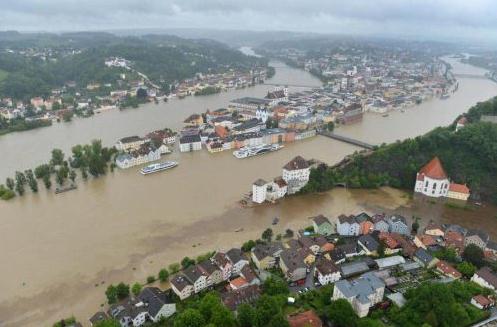
Europe Is Under Water.
The Chive
has an amazing collection of photos from recent (historic) flooding
across Europe, in some cases the worst since the early 1500s: "
These
images show how the recent heavy torrential rainfall has resulted in
dangerous flooding across Germany, Austria, Switzerland, Slovakia,
Poland and the Czech Republic."
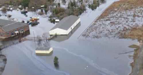
Flood Survival: What You Need To Know. I have a
feeling it's going to be a long, tough summer with plenty of flash
flooding from training thunderstorms. Here's an excerpt of a timely
story at
Outdoor Life Survival: "...
Some
floods develop slowly over a period of days from heavy rains and
hurricanes. Flash floods can develop quickly, sometimes in just a few
minutes and without any visible signs of rain. Tidal flooding can also
happen with or without rain in your area. Be aware of flood hazards no
matter where you live, but especially if you live in low-lying areas,
near rivers and bays, or downstream from a dam. Keeping an ear to the
radio or local TV stations is a great way to stay informed. In low-lying
or flood prone areas, a NOAA weather radio with an alarm can be a
life-saving investment.
FEMA and the National Weather Service use the following terms to announce flood information:
- Flood Watch: Flooding is possible. Tune in to NOAA Weather Radio, commercial radio, or local television for updated information.
- Flash Flood Watch: Flash flooding is possible.
Be prepared to move to higher ground. Listen to NOAA Weather Radio,
commercial radio, or television for information..."
Photo credit above: NOAA.
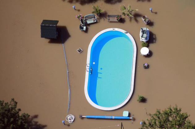
A Surreal Sight. Check out this story and collection of flood-related photos from Europe, courtesy of
Business Insider and Reuters: "
A
garden with a swimming pool is inundated by the waters of the Elbe
river during floods near Magdeburg in the federal state of Saxony
Anhalt, June 10, 2013. Tens of thousands of Germans, Hungarians and
Czechs were evacuated from their homes on Wednesday as soldiers raced to
pile up sandbags to hold back rising waters in the region's worst
floods in a decade..."
Space Weather Needs More Attention, Experts Say. It
would be ironic if the biggest threat originated not from a tornado,
hurricane, earthquake or tsunami, but from our nearest star. Could a
G-class (Black Swan) solar flare bring down our power grid? The idea
isn't as far-fetched as it sounds. Here's a clip from the
Courier-Post: "...
Experts
say the public pays little attention to solar flares, geomagnetic
storms and other conditions lumped into the “space weather” category.
Scientists themselves have begun only recently to understand its
patterns and effects and are developing more reliable ways to predict
activity. What they do know is there’s a lot at stake. A 2009 National
Academy of Sciences report warned of global disruption if a powerful
solar-powered storm affected Earth. Using evidence from storms in 1859,
1921 and 1989, the report said massive power outages would be
accompanied by radio blackouts and satellite malfunctions.
Telecommunications, GPS navigation, banking, finance and transportation
would all be affected..."
Image credit above: "
The largest solar storm in five years
erupted in March 2012, sending charged particles toward Earth with the
potential to disrupt power grids, navigation systems and satellites." / AP
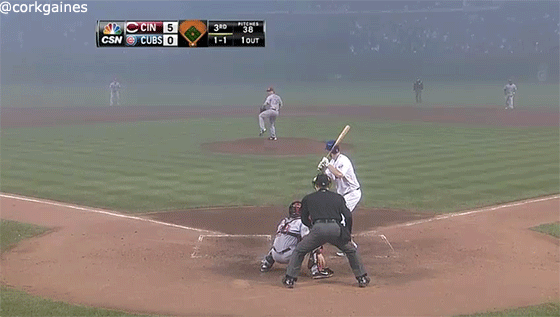
Play Misty For Me: Cubs, White Sox Play Fog Ball. The game must go on! Here's a funny clip from
SportsGrid: "
Brandon Phillips is The Smoke Monster. On a ridiculous fog-shrouded day at Wrigley Field (I mean, look at the field), Phillips had a grand slam and drove in all six of the Reds’ runs in a 6-2 win over the Cubs..."
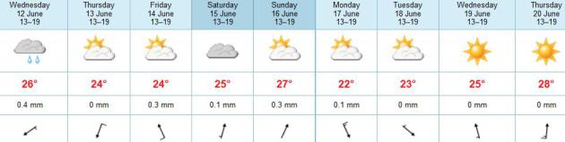
TODAY: Morning shower or thunderstorm possible (best chance far southern MN), PM clearing. Winds: N 10-15. High: 77
WEDNESDAY NIGHT: Clearing and pleasant. Low: 59
THURSDAY: Plenty of sun, pleasant. Best day in sight. High: 78
FRIDAY: Fading sun, late day thunder. Wake-up: 58. High: 76
SATURDAY: AM storms, then clearing. Wake-up: 63. High: near 80
SUNDAY: Sticky, few pop-upT-storms possible later in the day. Wake-up: 64. High: 82
MONDAY: Partly sunny, pleasantly warm. Wake-up: 63. High: 77
TUESDAY: Generous sunshine. feels like June again. Wake-up: 64. High: 81
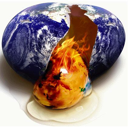
Climate Stories...
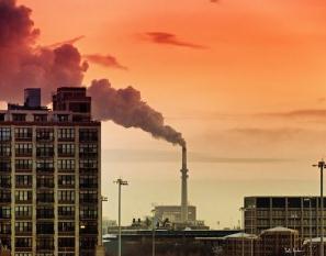
Greenhouse Gases Nearing Highly Dangerous Levels, Study Finds. Here's a clip from a story at
The Chicago Tribune: "...
The
IEA report, Redrawing the Energy-Climate Map, says carbon dioxide
emissions grew at a rate of 1.4% in 2012, releasing a record 31.6
gigatons into the atmosphere. On this current path, the world’s average
temperatures are on track to increase between 3.6 degrees Celsius to
5.3 degrees Celsius, or 6.48 degrees Fahrenheit to 9.54 degrees
Fahrenheit, by the end of the century, said the IEA, an independent
research group established by the world’s most industrialized nations.
“Climate change has quite frankly slipped to the back burner of policy
priorities,” said IEA Executive Director Maria van der Hoeven. “But the
problem is not going away — quite the opposite...”
Waiting On A New Climate Deal "Will Set World On A Path to 5C Warming". Here's an excerpt from an Op-Ed at the International Energy Agency's Chief Economist in
The Guardian: "...
The world cannot afford to wait for a new global climate change
agreement to come into force in 2020, because doing so will mean an
end to hopes of limiting global warming to moderate levels, one of the
world's foremost authorities on energy
has warned. Carbon dioxide emissions from energy rose by 1.4% in 2012
to a record high of more than 31bn tonnes, according to a report from the International Energy Agency on Monday, driven in part by a striking 6% rise in emissions from Japan following its phase-out of nuclear power and continuing growth in emissions from China.
Fatih Birol, chief economist at the IEA, and one of the world's most
respected energy experts, told the Guardian that greenhouse gas
emissions were continuing to rise so fast that pinning hopes on a
replacement for the Kyoto protocol would set the world on a path to 5C
of warming, which would be catastrophic..."


No comments:
Post a Comment