By Todd Nelson
As we approach the Summer Solstice on Friday, I have mixed feelings about the Spring we've had so far. Since February, monthly temperatures have been running below average and the first half of June is running below average too. The cool and wet Spring has helped with the drought, which is now completely gone from the Metro. Only 1% of the state near the Minnesota River Valley is considered to be in a severe drought; compared to January 1st when 83% of the state was was in a severe drought and 25% was in an extreme drought. Earlier this week, we managed to have back to back 80F degree high temperatures; something that has only happened one other time in May, two weeks after we had 0.5" of snow.
If you've been feeling a bit cheated out of "Minnesota Nice" weather, you're right, you have. Looking ahead, the good news is that the mild weather will continue. The bad news is that we will have several thunder chances through next week. A slow moving low pressure system will track across the international border and arrive by mid/late week. Our thunder threat will increase through the weekend with heavy rain possible at times. Sounds like summer to me!
____________________________________________________
Todd's Conservation MN Outlook for the Twin Cities and all of Minnesota:
WEDNESDAY: More sun, still pleasant. Warmer. Slight chance of late PM thunder. High: 82. Winds: S 10-15
WEDNESDAY NIGHT: Isolated thunder possible. Low: 65
THURSDAY: Some sun, scatterd T-storms late (some strong?), more humidity. High: 86
FRIDAY: Sticky. Stronger PM storms possible. Wake-up: 68. High: near 89
SATURDAY: Sticky with morning T-storms, some PM sun. Wake-up: 69. High: 88
SUNDAY: Some AM sun, PM T-storms pop. Wake-up: 69. High: 87.
MONDAY: Drier. Lingering PM thundershowers? Wake-up: 67. High: 84.
TUESDAY: Summer and unsettled. Wake-up: 65. High: 86.
____________________________________________________
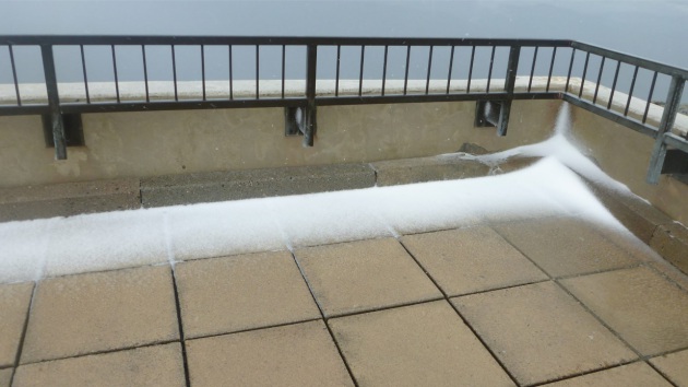
Mid-June Sleet-Drift?!?
No worries... this sleet isn't that close to home and it's around 6,288ft. Any guesses? Thanks to the Mt. Washington Observatory facebook page for the picture below. Tuesday weather atop the summit boasted a mid-June "sleet-drift". YIKES! It's too early for me to start thinking about sleet/snow, let's move on!
"Surprise! Colder-than-expected temperatures have resulted in on-and-off showers of ice pellets (sleet) over the last half-hour or so, resulting in the formation of a mid-June "sleet-drift" on our observation deck."
See more from Mount Washington Obervatory HERE:
Thundery Outlook Continues
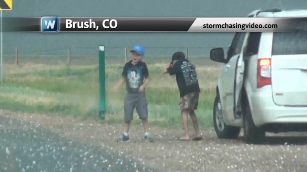
Thanks to stormchasingvideo.com for the image below in Brush, CO from earlier this week. I'd say that this is an example of what not to do. Kids playing around in a hail storm... It might seem like a fun idea at first until someones takes a large chunk of ice to the noggin, not to mention the threat of lightning in the area.
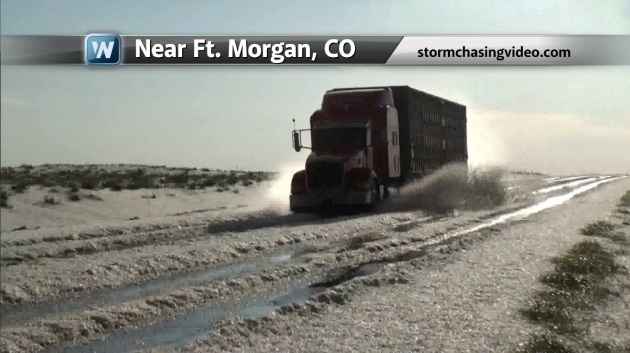
Here's another shot from stormchasingvideo.com where hail piles look more like snow piles! I know how hard it is drive in snow drifts, I couldn't imagine driving in hail drifts.

More Storms
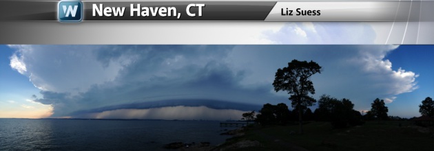
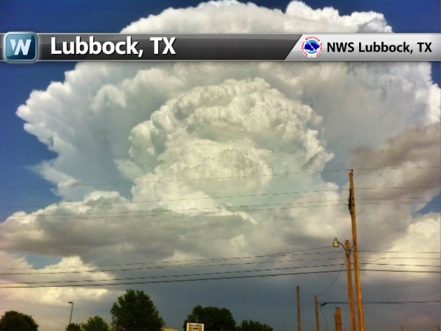
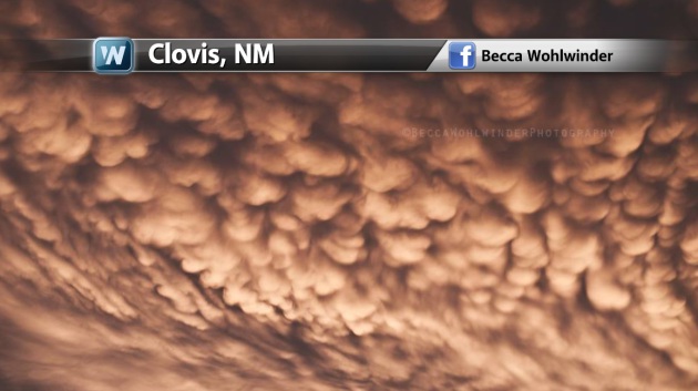
Thunderstorm activity was quite common across the country on Monday, June 17th. Here are some of the stormy pics from earlier this week.
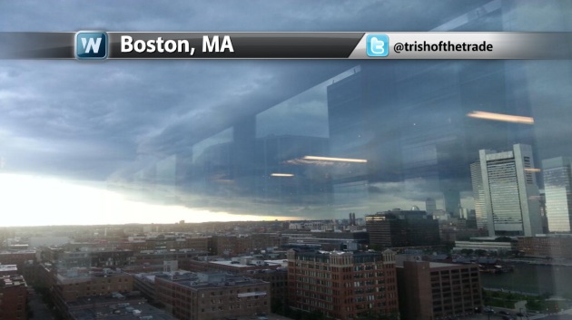
Stormy Monday
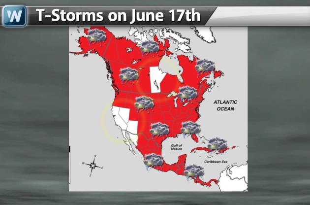
I though this was interesting... Take a look at how widespread thunderstorm activity was on Monday, June 17th. Even most Canada recorded lightning! Hawaii, California, Nevada and Arizona were the only U.S. states that didn't record lightning. Pretty wild huh?!?
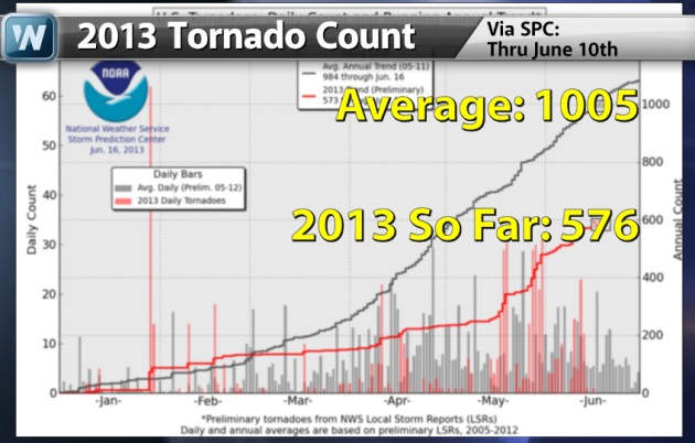
2013 Tornado Drought Continues
Despite seeing a recent uptick
in severe weather over the past several weeks, we are still well below
average for tornadoes in the month of June and for the year so far.
According to the SPC, there have been 95 PRELIMINARY tornado reports so
far through June 17th.
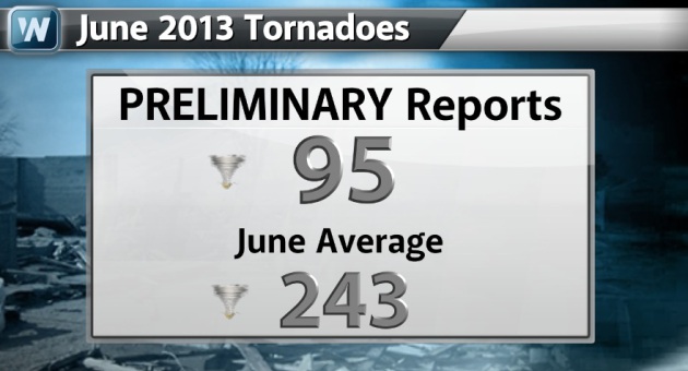
The SPC also has the 2013 PRELIMINARY count way less (576) than what we typically see at this time of the year (1005)!
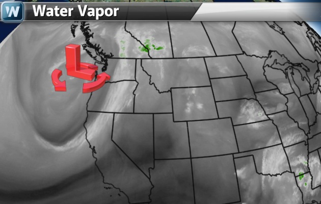
Severe Threat Continues This Week
Thanks to warm and humid air,
there will be several scattered thunderstorms across parts of the nation
through the rest of the week. We're also watching another slow moving
low pressure system in the Pacific Northwest, which will be the cause
for concern in the Midwest by late week/weekend.
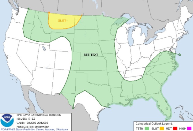
Severe Threat Wednesday
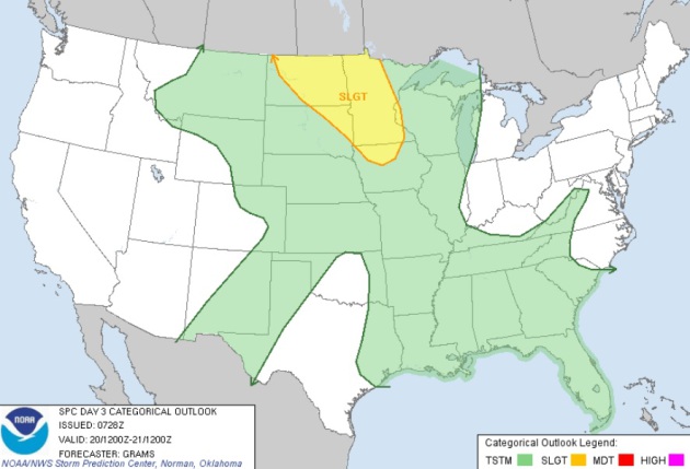
The SPC has a SLIGHT RISK of severe weather across parts of the HIGH Plains on Wednesday ahead of that Pacific Northwest low pressure system. Hail and high winds look to be the primary threat along with heavy rainfall potential, but an isolated tornado can't be ruled out.
...NRN ROCKIES/NRN HIGH PLAINS...
LEE CYCLOGENESIS WILL INDUCE THE CONTINUED NWWD TRANSPORT OF
MOISTURE INTO THE NRN HIGH PLAINS AND FEATURE 50S BOUNDARY LAYER
DEWPOINTS. STRONG SURFACE HEATING AHEAD OF THE APPROACHING
MID-LEVEL DISTURBANCE AND VERY STEEP MID-LEVEL LAPSE RATES /8-9 DEG
C PER KM/ WILL RESULT IN 1000-2500 J/KG MLCAPE BY PEAK HEATING
ACCORDING TO THE LATEST MODEL DATA. EXPECTING ISOLD-SCTD STORMS TO
DEVELOP BY THE MID AFTERNOON AND MOVE IN A GENERAL NWD DIRECTION
OWING TO THE MERIDIONAL CHARACTER TO THE MID-UPPER FLOW. THE
PRESENCE OF STEEP LAPSE RATES AND SIZABLE CAPE IN THE -10 TO -30 DEG
C LAYER SHOWN IN FORECAST SOUNDINGS WOULD SUPPORT A LARGE TO VERY
LARGE HAIL THREAT EVOLVING WITH THE MORE INTENSE UPDRAFTS
/SUPERCELLS/. THE PROPENSITY FOR COLD POOLS TO COALESCE TOWARDS
EVENING MAY INCREASE THE SEVERE WIND GUST THREAT AS CLUSTERS OF
STORMS MOVE FROM CNTRL MT TOWARDS THE CANADIAN BORDER AND NERN MT
DURING THE EVENING HOURS.
Severe Threat Thursday
...NRN PLAINS...UPPER MIDWEST...
GIVEN THE AFOREMENTIONED DISCREPANCIES IN THE HANDLING OF THE
SYNOPTIC PATTERN...CONFIDENCE IS LOW FOR HIGHLIGHTING SIGNIFICANT
SEVERE OR HIGHER COVERAGE PROBABILITIES ATTM. IT APPEARS THAT AN MCS
WILL PROBABLY BE ONGOING AT 12Z/THU INVOF MT/ND/SASKATCHEWAN BORDER.
THIS MAY CONTINUE TO MOVE EWD WITHIN MODERATE MID-LEVEL WLY FLOW AND
PERHAPS REDEVELOP/INTENSIFY E/SEWD INTO THE DIURNAL HEATING CYCLE
WITH ALL MODES OF SEVERE POSSIBLE GIVEN A MODERATE TO STRONGLY
UNSTABLE DOWNSTREAM AIR MASS. A STOUT CAPPING INVERSION AND
EXPANDING EML SHOULD LIMIT DIURNAL DEVELOPMENT WITH SRN EXTENT ALONG
ANY OUTFLOW AND CONFINE ACTIVITY MAINLY TO PARTS OF ND AND NWRN MN.
LOW-LEVEL WAA WILL STRENGTHEN THU NIGHT WITH A ROBUST LLJ FROM THE
SRN PLAINS TO THE MID-MO VALLEY. ALONG THE LEADING EDGE OF THE
CAPPING INVERSION...EITHER A CONTINUATION OF DIURNAL CONVECTION OR
DEVELOPMENT OF A RENEWED MCS APPEARS POSSIBLE WITH ATTENDANT SEVERE
WIND/HAIL THREATS.
Severe Threat Friday
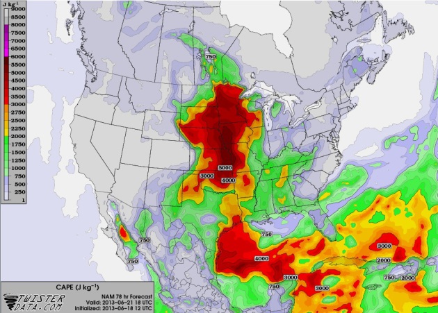
I still think Friday could be an interesting day ahead of the slow moving low pressure system. The Midwest could be in line for scattered thunderstorms, which may be severe... There is one thing, however, that could prevent thunderstorms from developing. The image below suggests how much energy or CAPE (Convective Available Potential Energy) will be present by midday. The big red blob over the Midwest would be considered significant potential energy for thunderstorms.
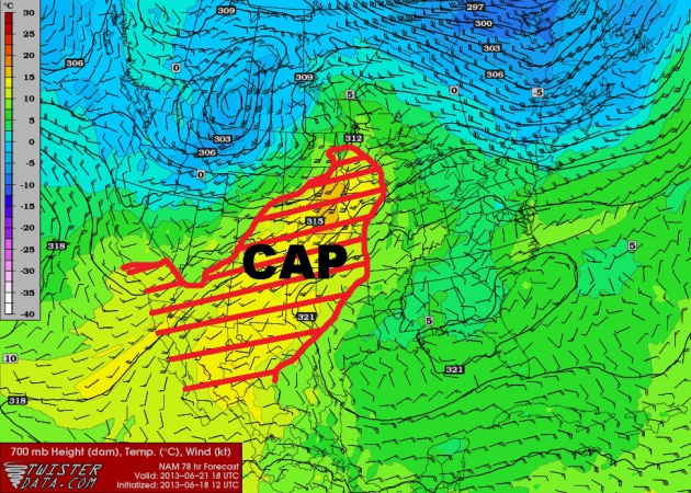
"CAPPED" on Friday??
One question remains about Friday and that is: Are temperatures aloft going to be too warm? A wedge of warmer air aloft would actually help to keep the thunder threat at bay. Yes, somestimes it can actually be too warm to thunder! A 'general' rule of thumb for a "Capping Inversion" is 10°C at 700mb. Anything warmer than that and thunder potential would be less likely. Anything cooler than that an thunder may be possible under given circumstances. 10°C at 700mb is also possible to overcome depending on circumstance too, so as I mentioned... Friday could be interesting late in the day for some folks across the far north if that "Cap" can be erroded. Stay tuned!
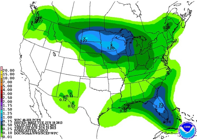
Upcoming Rainfall Potentail
NOAA's HPC 3 day rainfall forecast suggests a couple of pockets of heavy rainfall potentail through the end of the week. One located in the Southeast as a front lingers with shower and thunderstorm potential and another in the northern tier of the nation from the Pacific Northwest to the Midwest as that slow moving low traverses the international border.
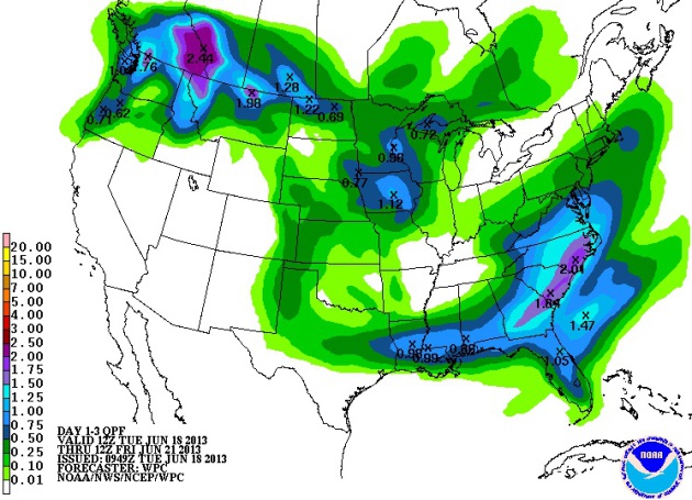
Additional Weekend Precipitation
On top of what we get through the rest of the week, some folks could stay fairly wet through the weekend, espeically those in the Midwest as the slow moving storm/front stalls. Several shower and thunderstorm chances will continue into the weekend there. A 5 day precipitation total from some in the Midwest by the end of the weekend could end up being as much as 1" to 2"+
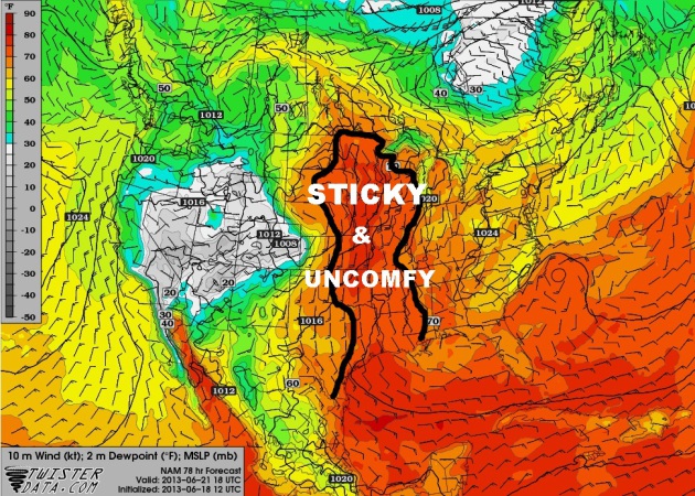
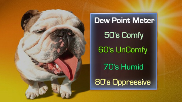
Sticky Weather Ahead...
Summery temps and humidity values will be on the rise over the next several days. I could see a big chunk of the nation in the 80s and 90s with dew point values in the uncomfy zone. The image below shows the dew point forecast midday Friday in the Humid and Uncomfy zone.
Thanks for checking in and have a great rest of your week
Don't forget to follow me on Twitter @TNelsonWNTV

No comments:
Post a Comment