74 F. average high on June 2.
76 F. high on June 2, 2012.
Frost Advisory in effect for northeastern MN and northern Wisconsin.
1.02" rain predicted by Friday morning in the Twin Cities.

The Wrong Message
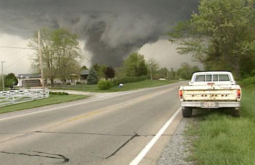
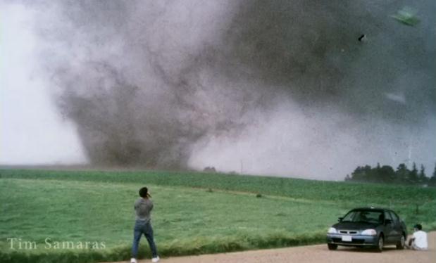
At least 9 people were killed in Friday
evening's Oklahoma City EF-3 tornado, including 3 professional tornado
researchers. Unlike amateur chasers out searching for a cheap thrill Tim
Samaras was pushing the envelope as a scientist. Previous projects
included planting "turtles" in the path of tornadoes to get video, wind
and pressure information.
On Friday one of the local OKC TV weathermen
encouraged viewers to get into their cars and try to drive away. The
result? Gridlock. Massive traffic jams. Tim, his son and a third tornado
intercept professional were caught in a deadly logjam of cars, unable
to escape to safety as the tornado took a sudden 45-degree turn.
Word to the wise: if you're already home and a Tornado Warning is issued stay home! Otherwise you're just a sitting duck.
A tragic story.
There's a Frost Advisory just northeast of MSP
this morning, more evidence of chilly air unusually far south with an
atmospheric tug of war playing out directly overhead. This will mean
more showery rains Tuesday & Wednesday; another slug of rain late
Saturday & Sunday. If it's any consolation (doubtful) it may be too
cool for anything severe.
The atmosphere still thinks it's May 3.
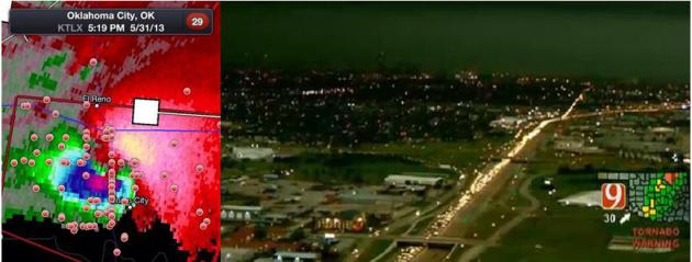
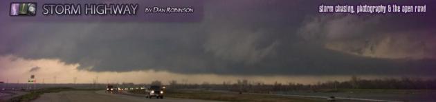
* Image upper left from RadarScope app shows
location of storm chasers in relation to El Reno tornado. Image upper
right shows traffic jam on I-35 south of Oklahoma City, courtesy of
KWTV.
A Few Thoughts About Tornado Chasing.
Things have really gotten out of control. This has been an accident
waiting to happen for the better part of 20 years now. On some level
I blame the movie "Twister", which glamorized tornado research and
inspired countless hundreds (thousands) of amateurs to try their hand at
a tornado intercept, with visions of great video and local or national
TV weather-glory. Ironic, since I helped with special effects with
"Twister" and even had a line in the movie. I don't want to be a
hypocrite. I was in Oklahoma on 3 separate occasions, intercepting
tornadic storms with NSSL, the National Severe Storms Lab. Every time I
went down to Oklahoma I was struck by the number of people tagging
along. Often scores, even hundreds of chasers would converge on the same
cell by late afternoon. It's a free country - you're obviously free to
drive when and where you want, and I certainly don't want that to
change, but something has to be done to avoid another tragedy like the
one that killed 9 motorists Friday evening, including 3 professional
tornado researchers Tim Samaras, his son, and intercept partner.
They weren't out there to videotape the tornado
and try to sell it to KFOR-TV or The Weather Channel. They were
conducting research, and yet the sheer number of chasers converging on
the El Reno supercell (apparently) made it impossible to get away from
an EF-3 erratic tornado in time. I honestly don't know what the solution
is here, but one would hope common sense would apply. With the May 20
EF-5 which leveled much of Moore, one of the local TV meteorologists
warned local residents that, without a basement or storm shelter, the
tornado was "unsurvivable" - he told them to get into their vehicle and
try to drive away before the tornado struck. That only makes sense if
you have HOURS of lead time, which just isn't realistic with the state
of tornado detection and warning, when the average lead-time is closer
to 13-15 minutes.
If you had 10 minutes and you were the ONLY one
trying to get out of Dodge, maybe. Just maybe. But the problem is this:
tens of thousands of local residents heard the same admonition, and if
everyone is trying to get onto the interstate to drive away from a
tornadic supercell, the result will most likely be gridlock, making you
and your family sitting ducks. A bad idea. If you're home, stay home.
Get into your tub (with bike or football helmets, if you have them) and
try to ride out the tornado on the ground floor, away from outer walls
and windows. Statistically that's still safer than getting into a car or
truck and trying to zip down the highway out ahead of a tornado. Friday
evening's multiple fatalities proved it.
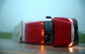
Photo credit above: "Overturned semitrailer from El Reno tornado, May 31, 2013." (Omaha World-Herald, Chris Machian/Associated Press).
* Andy Revkin has a write-up on the El Reno Tornado disaster in the New York Times here.
* USA Today questions the role of amateur tornado chasers in this Sunday article.
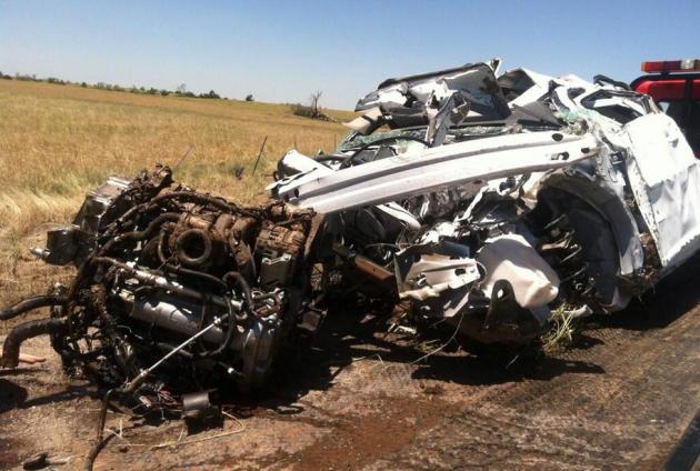
Unrecognizable. I'm not 100% certain, but I have a strong hunch this is the vehicle that Tim Samaras, his son and chase partner were driving when they were killed by the EF-3 El Reno tornado, that changed direction suddenly. If this doesn't make you shudder, and reconsider the wisdom of getting close to tornadoes, I'm not sure what will. Image courtesy of CNN.

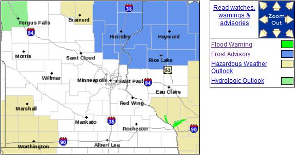
Where Are We Living Again? I had to do a double-take when I saw the Frost Advisory posted for northeastern MN and much of northern WI for early this morning. Are you kidding me? We're still witnessing a 4-6 week lag in the weather; as far as the atmosphere is concerned it's the last week of April or first week of May.
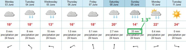
Ditto. Like cool and soggy? Well I have a forecast for you. We salvage a mostly-dry Monday, as clouds increase out ahead of the next trough of low pressure. Showers are likely Tuesday and Wednesday, the atmosphere probably too cool and stable for anything severe. We dry out (for a few hours) Thursday and Friday, before the next system comes in late Saturday into Sunday. ECMWF model guidance prints out 1.3" rain on Sunday.
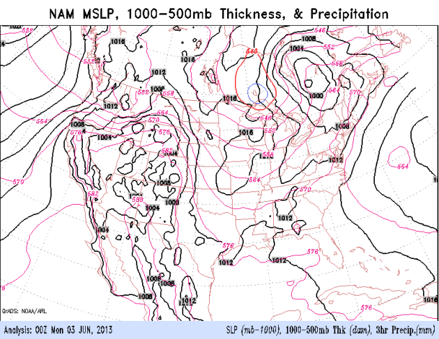
More Blobs. A southward-sagging jet stream, about 300-500 miles farther south than average, is bringing unusually chilly Canadian air into northern tier states. Storms are most likely to spin up along the boundary separating hot from cool, so as long as that huge north-south contrast is hovering nearby, with the core of the jet stream howling almost directly overhead, it's going to stay wet. 84 hour NAM loop courtesy of NOAA.
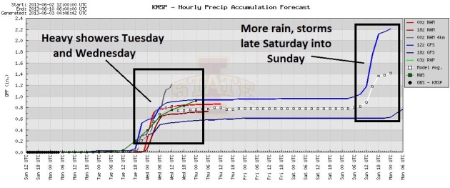
Timing The Puddles. All the models pull in some .5 to 1" rainfall amounts Tuesday and Wednesday, then a dry stretch most of Thursday, Friday and the first half of Saturday before more showers and T-storms slosh in; right now Sunday appears to be the wetter day of the weekend.
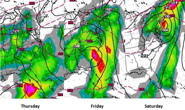
East Coast Tropical Depression? NHC only attaches a 20% risk of strengthening to tropical storm strength, but a moisture-laden depression or tropical wave will push flooding rains into Florida Thursday; the storm then pushing right up the east coast the end of the week, possibly soaking New York, Providence and Boston by Saturday. Stay tuned. ECMWF guidance above courtesy of WSI.
TODAY: Early sun, clouds increase by afternoon - late sprinkle. Winds: SE 10. High: near 70
MONDAY NIGHT: Mostly cloudy with a shower or two. Low: 50
TUESDAY: Showery rains likely. Cool, damp. High: 66
WEDNESDAY: A cool rain lingers much of the day. Wake-up: 55. High: 64
THURSDAY: Mostly cloudy, but a drier day. Wake-up: 54. High: 68
FRIDAY: Intervals of sun. Sneak out early. Wake-up: 53. High: 72
SATURDAY: Dry start, rain/T-storms may move back in by late PM. Wake-up: 54. High: 74
SUNDAY: Periods of rain. Have a Plan B. Wake-up: 58. High: 66
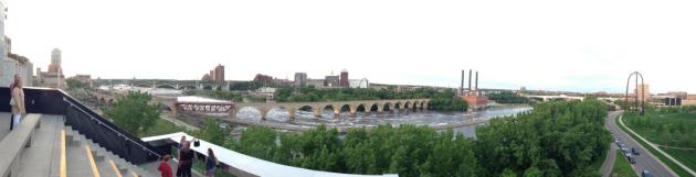
* photo above taken at the Guthrie Theater Sunday evening, where my wife and I took in "Primrose Path", which was excellent. That's me, pretending to have culture.
Climate Stories...

Photo credit above: "Thai students
urge people to quit smoking during 2001 World No-smoking day parade.
Steven Suranovic has compared societal dependence on fossil fuels to
individual addiction to tobacco." Photograph: Pornchai Kittiwongsakul/EPA.
No comments:
Post a Comment