69 F. high in the Twin Cities Sunday.
77 F. average high on June 9.
92 F. high on June 9, 2012.
.54" rain fell yesterday at KMSP.
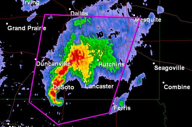
Slight severe threat over southern Minnesota Tuesday PM hours.
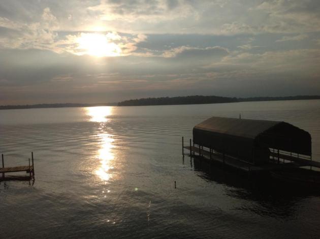
June Gloom
I just got home from Los Angeles, where I gave a
talk on extreme weather trends to the Department of Homeland Security.
No, I didn't fly to California to "see the sun" but I did manage to snap
a few photos of sunsets and smiling locals.
The timing was ironic, as Tropical Storm Andrea
unleashed record rains on New England and some towns in Europe were
cleaning up from the worst flooding in 500 years.
A few Santa Monica residents griped about June
Gloom, a thin, moist maritime layer sparking early overcast, typical for
June. Yes, the big forecast challenge in LA this time of year is "what
time will the sun come out?"
Insert yawn here.
We have our own unique flavor of meteorological
misery this year: stuck in a cool, wet rut, with storms every other day,
it seems. Some are wondering if we'll have a real summer? I'm still
betting on status quo - cooler than average with an occasional heat
spike. Nothing like last summer. The jet stream is too far south; the
main superhighway for storms howling almost directly overhead.
No sudden drought this summer.
The sun pops out today; a few 80s in the 7-Day. T-storms may sprout by Wednesday, again late Friday into Saturday AM.
Next weekend should be more lake-worthy. Like LA, without the gloom.
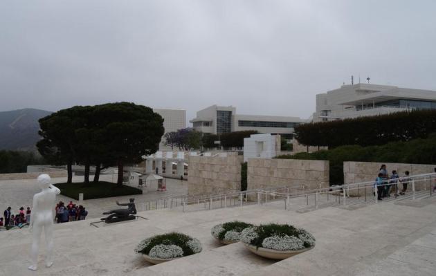
* I snapped the photo above from The Getty Museum Saturday morning,
when the "June Gloom", moisture streaming in off the Pacific, kept skies
overcast.
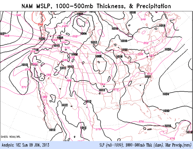
Weather Maps: More Like early May. The core of the
jet stream is (consistently) blowing 400-600 miles farther south than
normal for this time of year, pulling cooler Canadian air into the
northern tier states of the U.S. - setting the stage for a series of
sloppy storms from Seattle to the Twin Cities to Boston. I have a hunch
this will be the prevailing pattern for much of the summer.
Translation: cooler, and much wetter/stormier than normal.
June Skiing. I snapped this photo at 35,000 feet
somewhere above central Colorado last Thursday, amazed by the amount of
snow still on the ground above 7,000 feet - another symptom of our
tenuous spring. April was more like a (severe) March, May was typical
for early April. Maybe we'll finally get June weather after the 4th of
July.
Risk Of A Warm-Up. This week we finally limp into
June, highs mostly in the upper 70s to mid 80s. A few T-showers are
possible late Tuesday into early Saturday, another chance late Friday
into the first half of Saturday. No heat spikes (or heavy jackets)
looking out the next 7-9 days.
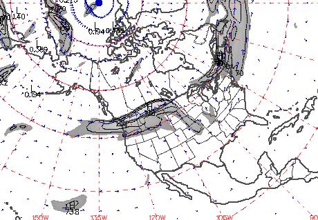
Tuesday Severe Threat. A wave of low pressure
rippling along a warm frontal boundary (with dew points well up into the
60s south and west of MSP) may spark a few strong to severe storms
tomorrow, especially central South Dakota into southern Minnesota and
northern Iowa. Source: NOAA SPC.
Waves Of Showers and T-storms. A surge of heat
pushing northward across the Plains will set off more strong to severe
storms Tuesday, conditions ripe for locally heavy rain across the Ohio
Valley the latter half of the week. 84 hour NAM loop: NOAA NCEP.
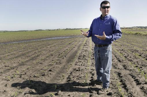
After Drought, Rains Plaguing Midwest Farms. Weather
whiplash over the Midwest is making national news. From drought to
flood, in the meteorological blink of an eye, and once againmany farmers
are suffering. Here's an excerpt from
The New York Times: "...
One
of the worst droughts in this nation’s history, a dry spell that
persisted through the early part of this year, has ended with torrential
rains this spring that have overwhelmed vast stretches of the country,
including much of the farm belt. One result has been flooded acres
that have drowned corn and soybean plants, stunted their growth or
prevented them from being planted at all. With fields, dusty and dry
one moment, muddy and saturated the next, farmers face a familiar fear —
that their crops will not make it. “This is the worst spring I can
remember in my 30 years farming,” said Rob Korff, who plants 3,500
acres of corn and soybeans here in northwestern Missouri. “Just
continuous rain, not having an opportunity to plant. It can still be a
decent crop, but as far as a good crop or a great crop, that’s not
going to happen...”
Photo credit: "
Rob Korff, a corn farmer who planed about a
month late this year after heavy rains that have made growing
difficult, in Norborne, Missouri, June 7, 2013. In many areas of the
Midwest, one extreme has given way to another, as flooded pastures have
delayed planting or washed away young shoots." (Steve Hebert/The New York Times)
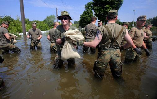
Flood Alert Forces 15,000 Germans To Flee, Threatens Hungary. Here is a clip from AFP &
The Australian: "
GERMAN
authorities have urged 15,000 more people to flee their homes in a
city on the swollen Elbe river as central Europe's worst floods in a
decade also threatened Hungary after causing havoc in the Czech
Republic and Austria. The river Danube reached a new record high in
Budapest but the Hungarian capital's mayor sought to ease concerns,
saying water levels were stabilising, although about 1200 people were
evacuated along the river. The deluge has also sparked massive
emergency responses in Austria and Slovakia. A torrent of flood waters
in Germany has turned vast areas into a brown water world, sparked a
mass mobilisation of emergency workers and caused billions of euros in
damage in what one MP termed a "national catastrophe"...
Photo credit above: "
German army soldiers work at a dike
in the city of Magdeburg, eastern Germany, Sunday June 9, 2013.
Thousands of people have been evacuated from their homes in a region of
eastern Germany where the Elbe river has flooded and burst through a
dam, officials said Sunday. More than 20 people have been killed by a
week of flooding in central Europe, as rivers such as the Danube, the
Elbe and the Vlatava have overflowed after heavy rains and caused
extensive damage in central and southern Germany, the Czech Republic,
Austria, Slovakia and Hungary." (AP Photo/dpa, Jens Buettner)
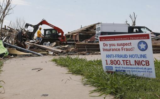
Insight: In Tornado Alley Building Practices Boost Damage.
The reality: it all comes down to building codes. Outside of Hurricane
Alley (coastal communities from Brownsville to Portland) building codes
are more lax; homes only built to withstand 75 mph winds. A home or
office could be constructed to be "tornado-proof", but costs would
probably be prohibitive. Could (most) homes be constructed to withstand
(most) tornadoes? Probably. If Oklahoma building codes could be raised
to the standards of Florida more homes (and homeowners) could survive
tornadoes. Here's an excerpt of an interesting story at
The Chicago Tribune: "...
This
notion that we cannot engineer buildings economically to withstand
tornado loads is a fallacy," said Prevatt, who has studied damage from
hurricanes and the devastating tornadoes in 2011 in Joplin, Missouri and
Tuscaloosa, Alabama. The cost of damage from tornadoes is soaring in
the United States even though National Weather Service historical data
shows no significant rise in the number of storms. The last five years have seen the highest losses from thunderstorm
damage in U.S. history, according to an analysis by insurer Munich RE..."
Photo credit: "
A sign warning against insurance fraud is
displayed as heavy equipment is put to use removing debris from a home
destroyed by the May 20th tornado in the Plaza Towers neighborhood of
Moore, Okla., Friday, June 7, 2013." (AP Photo/Sue Ogrocki)
Scientists Hope To Predict Tornadoes By Using Little Drones.
I can see every TV station having their own drone. Drone7! Just when
you thought it couldn't get any crazier, check out this story at
The Los Angeles Times: "
Tornadoes
used to strike without any warning. Since the 1970s, meteorologists
have worked to bring the average warning time up to 13 minutes. A
combination of weather balloons, radar and on-the-ground observations
form the core of today's forecasting technology. Now scientists have a
new goal: extending the warning time from minutes to hours by sending
unmanned aircraft — drones — into a brewing storm. Pulling that off
would require not only technological expertise but also flexibility in
government rules that block most such flights. Until now, most of the
work on unmanned aircraft has been for military or public safety uses.
But researchers are increasingly exploring their use in science,
including severe weather research..."
Is Climate Change Increasing Tornado Intensity? The
short answer: we're not sure. A warmer, wetter atmosphere may fuel more
severe thunderstorms, but changes in wind shear in a warming world may
impact tornadogenesis. Here's a clip from
Huffington Post: "...Global
warming is making wet places wetter and dry places drier, and creating
moisture-laden air that fuels hurricanes and snowstorms, making them
much worse than they otherwise would be in a climate unchanged by human
behaviors. [
The New Normal: Deluge]
But we can't necessarily say the same about tornadoes, at least not
yet. The tornado connection to global warming is tenuous, and for
several reasons. Chief among them is the fact that climate change
apparently affects the two major factors influencing tornadoes — energy
and wind shear — in completely opposite ways..."
Photo credit above: AP. "
Lightning strikes from a storm
illuminate a home damaged by a tornado on Hyde Park Lane at Country
Club Rd. in Cleburne, Wednesday night, May 15, 2013."
Only In L.A. Friday evening we attended a free block
party outside City Hall, honoring the outgoing mayor. In attendance:
(from left to right) Ryan Seacrest, Stevie Wonder, Mayor Villaraigosa,
Bill Clinton, Wanda Sykes and Placido Domingo. Only in L.A.
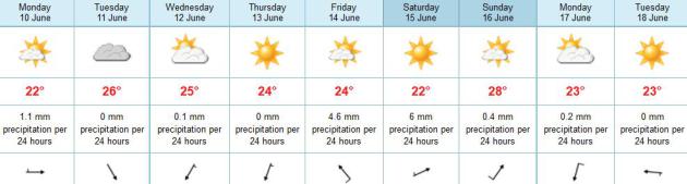
TODAY: Partly sunny, pleasant again. Winds: W 3-8. High: 78
MONDAY NIGHT: Partly cloudy, dry. Low: 63
TUESDAY: Warmer. Isolated T-storm late, a few may be severe south/west of MSP. High: 83
WEDNESDAY: Muggy, few T-storms nearby. Wake-up: 66. High: 81
THURSDAY: Plenty of sun, take the day off. Wake-up: 62. High: 82
FRIDAY: Sunny start, T-storms arrive late. Wake-up: 64. High: 81
SATURDAY: Wet, stormy start. Slow PM clearing. Wake-up: 66. High: 82
SUNDAY: Partly sunny. Late-day thunder possible. Wake-up: 65. High: 83
Climate Stories...
Climate Science Tells Us Alarm Bells Are Ringing. Here's a portion of an Op-Ed at
The Washington Post: "...
projections from an array of scientific analyses summarized by the National Academy of Sciences
and most of the world’s major scientific organizations indicate that
by the end of this century, people will be experiencing higher
temperatures than any known during human civilization — temperatures
that our societies, crops and ecosystems are not adapted to. Computer
model projections from at least 27 groups at universities and other
research institutes in nine countries have proved solid. In many cases,
they have been too conservative, underestimating over the past 20 years
the amounts of recent sea-level rise and Arctic sea ice melt. Much
has been made of a short-term reduction in the rate of atmospheric
warming. But “global” warming requires looking at the entire planet.
While the increase in atmospheric temperature has slowed, ocean warming rose dramatically after 2000. Excess heat is being trapped in Earth’s climate system, and observations of the Global Climate Observing System and others are increasingly able to locate it. Simplistic interpretations of cherry-picked data hide the realities..." (Image: Climate Central).


No comments:
Post a Comment