77 F. high on Monday in the Twin Cities.
77 F. average high on June 10.
93 F. high on June 10, 2012.
16.46" precipitation since January 1.
10.88" normal precipitation since January 1.
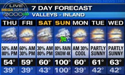
Mega Doppler
One of the local news channels in Los Angeles
touts "Megadoppler", which is ironic, since most summer days the only
thing their Doppler is detecting is dust, drizzle, wildfire plumes -
maybe an occasional L.A. Laker?
Doppler has revolutionized tornado prediction,
allowing us to zero in on rotating T-storms most likely to spin up a
twister. The problem: not every twisting storm will tornado. In fact 70
percent of tornado warnings wind up as false alarms.
It's always good to err on the side of safety & caution but too many false alarms & people tune out.
If these rains keep up you'll need a machete to
cut your jungle-like lawn this weekend. We've gone from dry, dusty
topsoil to farmers unable to get into their muddy fields, all in the
span of a few months. A remarkable turn-around.
The core of the jet stream is creeping farther
north, allowing warmer, more summer-like air to push into Minnesota. Dew
points may hit 70F today: tropical jet-fuel for strong storms tonight
and Wednesday; another chance of T-storms late Friday into Saturday
morning. Sunday looks like the drier day to salvage some sunscreen-time
on the bike, boat or deck.
Amazingly, you may even be able to work up a minor sweat!
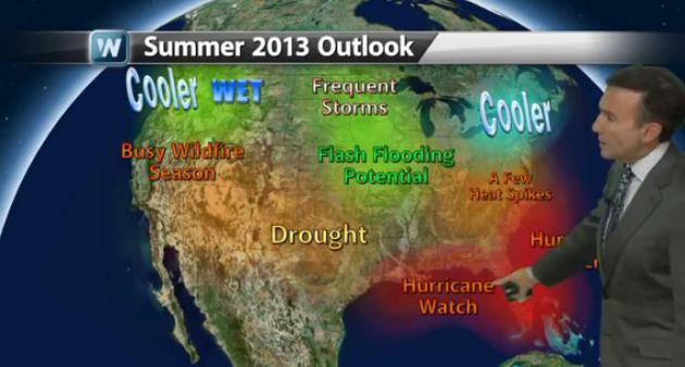
Out On A Limb - Again. Is our cool, unsettled,
sloppy June a preview of the summer to come? Probably. There is a
correlation, and to pretend otherwise would be a waste of your time.
We'll see heat spikes, but the pattern is remarkably persistent and
resilient, jet stream steering currents setting up an average of 300 to
600 miles farther south than 2012. That means chilly air at our northern
doorstep, a tug-of-war taking place overhead, meaning frequent weather
changes and a cool, wet bias, probably into at least July, maybe longer.
Here is the latest edition of
Climate Matters.
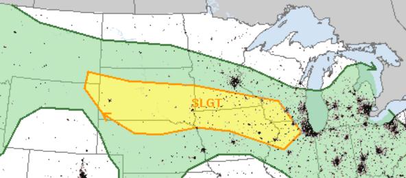
Tuesday Severe Risk. A slow moving warm frontal
passage, coupled with rising dew points (close to 70F) and strong
instability + marginal wind shear may set off a few severe storms later
today and tonight - the greatest risk coming from large hail and
damaging straight-line winds. Source: NOAA SPC.
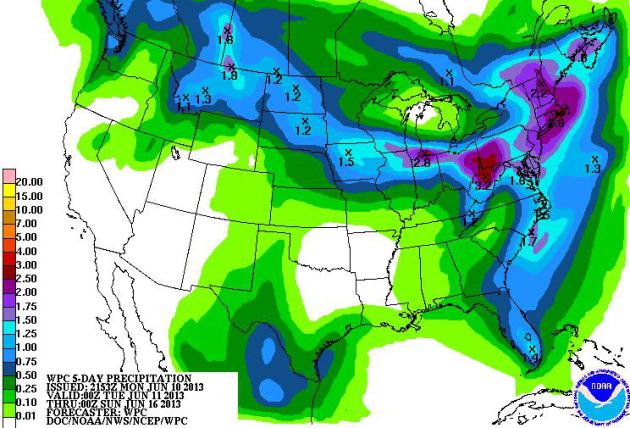
Tracing The Outline Of Prevailing Jet Stream Winds.
Check out the plume of 1-3"+ rains predicted from Montana to Iowa,
Chicago, Pittsburgh and Boston, evidence of jet stream winds still
unusually far south for mid June. More flash flooding is likely from the
Ohio Valley into New England. Map: NOAA NCEP.
Trending Warmer. We've graduated from 60s to 70s and
low 80s - temperatures inching in the right direction. ECMWF model data
indicates a slight thunder risk later today, a better chance of
T-storms Wednesday. Odds favor a drier, warmer weekend - it HAS to be
better than last weekend.
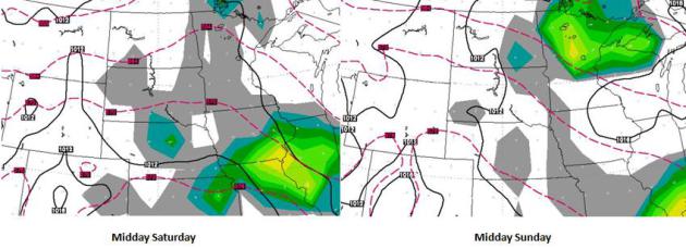
Weekend Preview. No widespread, steady or sustained
(frontal) rains are expected right now for the weekend; scattered
T-storms are most likely south of MInnesota Saturday, a few T-storms may
sprout over central and northern Minnesota by midday Sunday as a warm
frontal boundary creeps north across the state. ECMWF model data
courtesy of WSI.
After Drought, Rains Plaguing Midwest Farms. Weather
whiplash over the Midwest is making national news. From drought to
flood, in the meteorological blink of an eye, and once againmany farmers
are suffering. Here's an excerpt from
The New York Times: "...
One
of the worst droughts in this nation’s history, a dry spell that
persisted through the early part of this year, has ended with torrential
rains this spring that have overwhelmed vast stretches of the
country, including much of the farm belt. One result has been flooded
acres that have drowned corn and soybean plants, stunted their growth
or prevented them from being planted at all. With fields, dusty and
dry one moment, muddy and saturated the next, farmers face a familiar
fear — that their crops will not make it. “This is the worst spring I
can remember in my 30 years farming,” said Rob Korff, who plants 3,500
acres of corn and soybeans here in northwestern Missouri. “Just
continuous rain, not having an opportunity to plant. It can still be a
decent crop, but as far as a good crop or a great crop, that’s not
going to happen...”
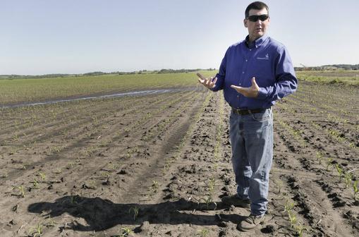
Photo credit: "
Rob Korff, a corn farmer who planed about a
month late this year after heavy rains that have made growing
difficult, in Norborne, Missouri, June 7, 2013. In many areas of the
Midwest, one extreme has given way to another, as flooded pastures have
delayed planting or washed away young shoots." (Steve Hebert/The New York Times).
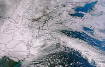
* Flood zone will cover roughly 1/4 of New York City metro by 2050s. The New York Times has details
here.
Bloomberg To Propose Spending Billions to Reduce Storm Risk.
Bloomberg (the excellent news and information web site, mobile app and TV station) has more details: "
Almost eight months after Hurricane Sandy flooded New York’s subways, destroyed homes and blacked out half of Manhattan, Mayor Michael Bloomberg
will propose spending billions of dollars to mitigate storm risk along
the city’s more than 500 miles of coastline. Mindful of environmental
scientists’ predictions that sea levels around the city may rise 12 to
55 inches by 2080, the mayor tomorrow will unveil a capital spending
plan to mitigate the dangers, his office said. “As bad as Sandy was,
future storms could be even worse,” the mayor said in remarks prepared
for delivery tomorrow. “Because of rising temperatures and sea levels,
even a storm that’s not as large as Sandy could be -- down the road --
even more destructive.” By mid-century, as much as one-quarter of New
York’s land area, where 800,000 residents live, will be in a flood
plain, the mayor plans to say..."
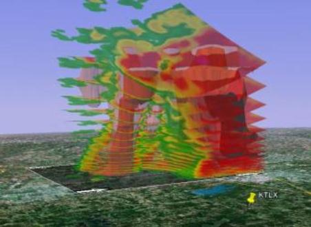
Visualizing The May 2013 Moore, Oklahoma Tornado. Here's interesting perspective from
NOAA NCDC,
the National Climatic Data Center, showing how tracking tornado debris
on Doppler can provide clues about the wind circulation inside the
supercell that whipped up an EF-5 strength super-tornado over Moore,
Oklahoma on May 20: "...
The Oklahoma City weather radar, or KTLX, is
about 13 miles directly east of the Moore, Oklahoma, tornado, and it
observed the entire life of the tornado from 2:56 p.m. to 3:35 p.m.
Central Time on May 20, 2013. The KTLX weather radar took 14 different
elevation scans of the atmosphere between 3:16 p.m. and 3:20 p.m.,
detecting the tornado debris as it moved eastward. NCDC scientists used
the Weather and Climate Toolkit
to produce multiple visualizations of the tornado and its devastation
based on the data from the KTLX weather radar. In these visualizations,
the vertical scans are exaggerated by a factor of two, making them
easier to see. Google Earth is also used to display the data in three
dimensions. Click the links below to download and view the
visualizations of the Moore, Oklahoma, tornado produced by NCDC..."
Insight: In Tornado Alley Building Practices Boost Damage.
The reality: it all comes down to building codes. Outside of Hurricane
Alley (coastal communities from Brownsville to Portland) building
codes are more lax; homes only built to withstand 75 mph winds. A home
or office could be constructed to be "tornado-proof", but costs would
probably be prohibitive. Could (most) homes be constructed to withstand
(most) tornadoes? Probably. If Oklahoma building codes could be raised
to the standards of Florida more homes (and homeowners) could survive
tornadoes. Here's an excerpt of an interesting story at
The Chicago Tribune: "...
This
notion that we cannot engineer buildings economically to withstand
tornado loads is a fallacy," said Prevatt, who has studied damage from
hurricanes and the devastating tornadoes in 2011 in Joplin, Missouri
and Tuscaloosa, Alabama. The cost of damage from tornadoes is soaring
in the United States even though National Weather Service historical
data shows no significant rise in the number of storms. The last five years have seen the highest losses from thunderstorm
damage in U.S. history, according to an analysis by insurer Munich RE..."
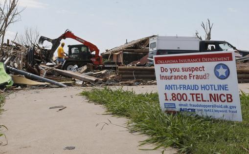
Photo credit: "
A sign warning against insurance fraud is
displayed as heavy equipment is put to use removing debris from a home
destroyed by the May 20th tornado in the Plaza Towers neighborhood of
Moore, Okla., Friday, June 7, 2013." (AP Photo/Sue Ogrocki)
Scientists Hope To Predict Tornadoes By Using Little Drones.
I can see every TV station having their own drone. Drone7! Just when
you thought it couldn't get any crazier, check out this story at
The Los Angeles Times: "
Tornadoes
used to strike without any warning. Since the 1970s, meteorologists
have worked to bring the average warning time up to 13 minutes. A
combination of weather balloons, radar and on-the-ground observations
form the core of today's forecasting technology. Now scientists have a
new goal: extending the warning time from minutes to hours by sending
unmanned aircraft — drones — into a brewing storm. Pulling that off
would require not only technological expertise but also flexibility in
government rules that block most such flights. Until now, most of the
work on unmanned aircraft has been for military or public safety uses.
But researchers are increasingly exploring their use in science,
including severe weather research..."
Is Climate Change Increasing Tornado Intensity? The
short answer: we're not sure. A warmer, wetter atmosphere may fuel more
severe thunderstorms, but changes in wind shear in a warming world may
impact tornadogenesis. Here's a clip from
Huffington Post: "...Global
warming is making wet places wetter and dry places drier, and
creating moisture-laden air that fuels hurricanes and snowstorms,
making them much worse than they otherwise would be in a climate
unchanged by human behaviors. [
The New Normal: Deluge]
But we can't necessarily say the same about tornadoes, at least not
yet. The tornado connection to global warming is tenuous, and for
several reasons. Chief among them is the fact that climate change
apparently affects the two major factors influencing tornadoes — energy
and wind shear — in completely opposite ways..."
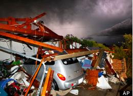
Photo credit above: AP. "
Lightning strikes from a storm
illuminate a home damaged by a tornado on Hyde Park Lane at Country
Club Rd. in Cleburne, Wednesday night, May 15, 2013."
Inside The Immortality Business. Here's an amazing read (troubling on so many levels) from
Buzzfeed: "
Some
things should not be left to the last minute. For instance, having
yourself frozen. The act of being preserved in a giant thermos cooled
by liquid nitrogen in the hopes that the scientists of the future will
figure out how to revive you and repair whatever it was that drove you
to require freezing in the first place is no small matter. There are
insurance policies to settle upon. Legal documents to notarize.
Relatives to appease. And all of this must be done far enough in advance
that arrangements can be made for a field response team to reach you
on your deathbed and stand by until a doctor declares you medically
deceased, at which time they will leap into action and begin your
cryopreservation. Legally speaking, cryonics is okay because it’s
considered an extravagant funeral practice. Its few practitioners would
not argue with the notion that the procedure would be more effective if
started before the heart has taken its final beats, but to do so would
be illegal, even if the soon-to-be-deceased is a willing participant.
Thus, the process waits for death, and the longer after death it
begins, the worse off you are. This is why the Alcor Life Extension
Foundation really doesn’t like to accept last-minute cases...."
I'd Watch This. Thanks to
Lorange Blog for sharing this. I'm suddenly hungry for big bites of weather information.
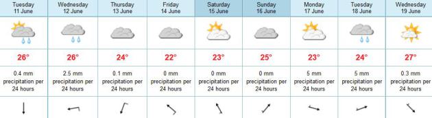
TODAY: Dew point near 70. Very sticky, isolated T-storm possible. Winds: SE 5. High: 81
TUESDAY NIGHT: Muggy with T-storms, locally heavy rain possible. Low: 65
WEDNESDAY: More numerous T-storms, downpours possible. High: 78
THURSDAY: More sunshine, a good June day. Wake-up: 62. High: 82
FRIDAY: Warm sun; late PM T-storms. Wake-up: 64. High: 81
SATURDAY: Early thunderstorms, some PM sun. Wake-up: 65. High: 79
SUNDAY: Partly sunny, PM storms up north. Wake-up: 63. High: 82
MONDAY: Muggy sunshine. Stray storm possible. Wake-up: 65. High: 83
Climate Stories...
Op-Ed: Climate Change Threatens America's National Security.
Retired Marine Corps Brig. Gen. Stephen Cheney, of the American
Security Project, says rising sea levels and extreme drought could be
just as dangerous as terrorists and crises. Here's an excerpt from
takepart.com: "...
The
effects of this temperature change are severe. Climate change is
usually presented as an environmental problem, but the consequences—and
the consequences of the consequences—present real national security
threats to the United States. First, climate change generates new
security risks around the world. Although climate change may not
directly cause violent conflict, it acts as “an accelerant of
instability” or a “threat multiplier.” That is, it makes conflict more
likely, or intensifies conflict already underway. For example, climate
change wreaked havoc on Mali, a poor, dry Saharan nation with an
unstable government. As rivers dried up and agricultural production
suffered, Al-Qaeda-linked militants capitalized
on instability and overthrew the government in 2012. We cannot say
that climate change has caused conflict in Mali, but it clearly
multiplied the already existing threats..."
Elite Flyers Pressure United Airlines To Act On Climate Change. Reuters and
The Chicago Tribune has the story; here's an excerpt: "
...A
group of United Airlines' most frequent flyers, including billionaire
investor Tom Steyer, on Monday called on the big airline to stop
blocking climate change actions. United Airlines Inc has opposed
"multiple efforts to curb climate change pollution, at home and
abroad," the group, Flying Clean, said in a letter to Chief Executive
Jeff Smisek. Flying Clean, launched by several nongovernmental
organizations seeking to reduce carbon emissions from airplanes, sent
its letter ahead of United's annual shareholder meeting on Wednesday in
Arlington, Virginia. It had 85,000 electronic signatures including
2,700 elite frequent flyers..."
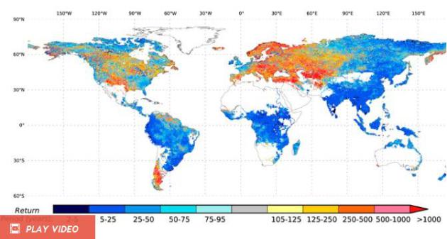
Global Floods Of The Future. It's basic physics: as
the atmosphere warms it can hold more water vapor, more fuel for storms
(and floods). Here's an excerpt from
Discovery.com: "...
In
terms of the number of people exposed to flood risks, they found that
depends on the temperatures to which things heat up. With a 2-degree
Celsius rise in temperature, about 27 million people will be exposed to
more floods. With a 4 degrees C warming the exposure rises to 62
million and at 6 degrees C it is up to 93 million people. The climate
models were also used to study the outlets of some river basins. There
they saw the frequency of floods increasing during the twenty-first
century in just about every selected rivers in South Asia, Southeast
Asia, Oceania, Africa and Northeast Eurasia. They also predict that
what were considered 100-year floods in the 20th century will occur
every 10 to 50 years in the 21st century..."
Graphic credit above: "
Projected return period (in years)
in the 21st Century for river discharges matching what in the 20th
Century were 100-year floods." Dr Sujan Koirala
Climate Science Tells Us Alarm Bells Are Ringing. Here's a portion of an Op-Ed at
The Washington Post: "...
projections from an array of scientific analyses summarized by the National Academy of Sciences
and most of the world’s major scientific organizations indicate that
by the end of this century, people will be experiencing higher
temperatures than any known during human civilization — temperatures
that our societies, crops and ecosystems are not adapted to. Computer
model projections from at least 27 groups at universities and other
research institutes in nine countries have proved solid. In many cases,
they have been too conservative, underestimating over the past 20
years the amounts of recent sea-level rise and Arctic sea ice melt.
Much has been made of a short-term reduction in the rate of
atmospheric warming. But “global” warming requires looking at the
entire planet. While the increase in atmospheric temperature has
slowed, ocean warming rose dramatically after 2000. Excess heat is being trapped in Earth’s climate system, and observations of the Global Climate Observing System and others are increasingly able to locate it. Simplistic interpretations of cherry-picked data hide the realities..." (Image: Climate Central).


No comments:
Post a Comment