By Todd Nelson
"Patience is a virtue" - HA! Tell that to any Minnesotan right now and you might get bopped in the nose. I'm beginning to think that most Minnesotan's patience for the weather is running out, I know mine is a bit thin.
This will be the 11th consecutive weekend that there has been precipitation reported 'officially' at the Minneapolis/St. Paul International Airport. I had to go back all the way to March 23rd and 24th to find a weekend that was COMPLETELY dry! The Twin Cities had it's 4th wettest Meteorological Spring on record with 13.5" of precipitation, which was nearly 6" above normal! Rochester actually had it's wettest and 7th coolest March-April-May period on record. Fish cycles at Minnesota lakes seem to still be a bit goofed up thanks to a number of record latest ice out dates too.
It almost seems like our local weather is running one month behind itself this year. May turned out to be a little more like April and June may turn out to be a little more like May. With that said, I do see some potential warmth in the extended forecast. Temperature maps near you may actually get back into the 80s this week! Now, if we could just get some sun...
__________________________________________
Todd's CONSERVATION MN Outlook for the Twin Cities and all of Minnesota
SUNDAY: Cooler, soggier day of the weekend with scattered showers and storms High: 65. Winds: E 15mph
SUNDAY NIGHT: Mostly cloudy with a few showers. Low: 56
MONDAY: Lingering AM clouds and sprinkles. A little more PM sun. High: 76
TUESDAY: Drier, a little sunnier and warmer. Isolated storm possible in SW MN late? Wake-up: 62. High: 81
WEDNESDAY: Spotty storms drift through southern Minnesota. Wake-up: 63. High: 78
THURSDAY: More June-like. Wake-up: 63. High: 80.
FRIDAY: Mild. A few late day storms. Wake-up: 63. High: 81.
SATURDAY: Unsettled start. Better/warmer afternoon. Wake-up: 64. High: 82.
_____________________________________________
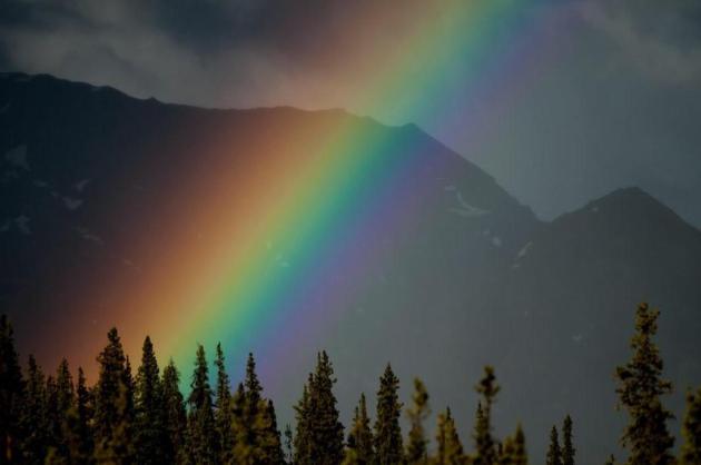
Somewhere Over The Rainbow
This is truely one of the best pictures I've seen in quite some time. Thanks to the Denali, AK National Park Service for the picture below. There has to be one massive pot of gold on the other side of those trees!
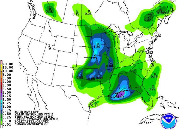
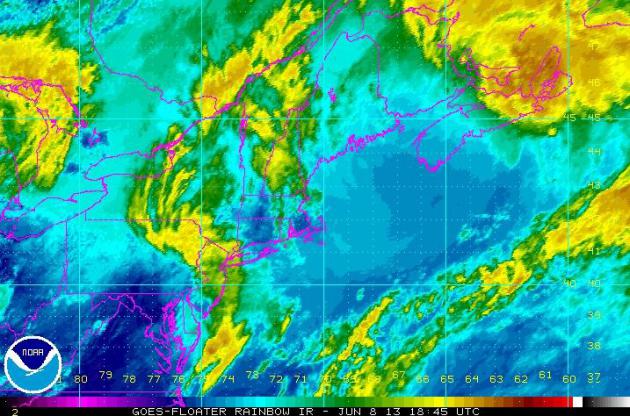
Soggy Sunday Ahead
NOAA's HPC precipitation forecast for Sunday looks a bit wet for some. Note the bigger blob of heavier rainfall over the northcentral part of the country and also down in the Gulf Coast region. Convective showers (thunderstorms) look to dump heavy pockets of rainfall (1" to 2"+ possible) in spots from PM Saturday thru PM Sunday. Note also how the West looks to stay dry.
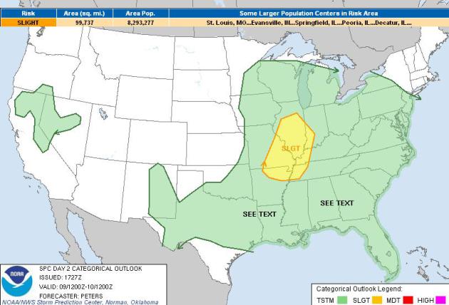
Sunday Severe Threat
The Storm Prediction Center has issued a SLIGHT RISK of severe weather for parts of the Mid Mississippi Valley on Sunday. A fairly vigorous area of low pressure in the Midwest will help to initiate more strong thunderstorm and heavy rain potential across the northcentral part of the country.
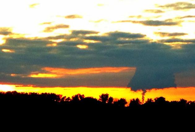
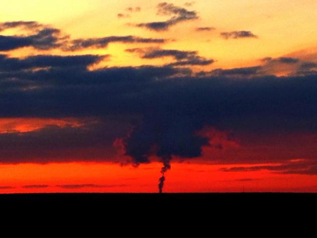
Tornado Look-Alike?
I thought this was interesting... I was driving around the Northwest Twin Cities suburbs Friday evening and spotted a tornado look-alike! This 'feature' has been actually been reported as a tornado during stormier times in the past. As it turns out, this is actually from a powerplant! Note: It is always best to be aware of your surroundings and know what's what before reporting any scary looking clouds!
So Long Andrea
Our first named storm of the 2013 Atlantic Hurricane Season has come and gone. Other than some tornado reports on Thursday and isolated wind damage reports through the early weekend, Andrea was more of a heavy rain producer. Keep in mind that the eastern half of the country is generally drought free, so it's not necessarily busting any drought. It would be nice to see one of these tropical storms (light wind threat), slide into the Gulf of Mexico and bring rain to parts of the Rockies and the Front Range of the Rockies where the drought is at it's worst!
Soaking Eastern Rainfall
Radar estimated rainfall over the past 7 days suggests that 3" to 6"+ fell in a widespread area across the Eastern Seaboard, mostly thanks to Andrea. Note the heavier pockets of rain in the Central and Southern Plains (and Montana). Nice to see some rainfall there, where drought conditions persist. Also note how the Southwest was mainly dry during the last 7days! Unfortunately, hot and dry weather conditions are aiding in fire weather concerns.
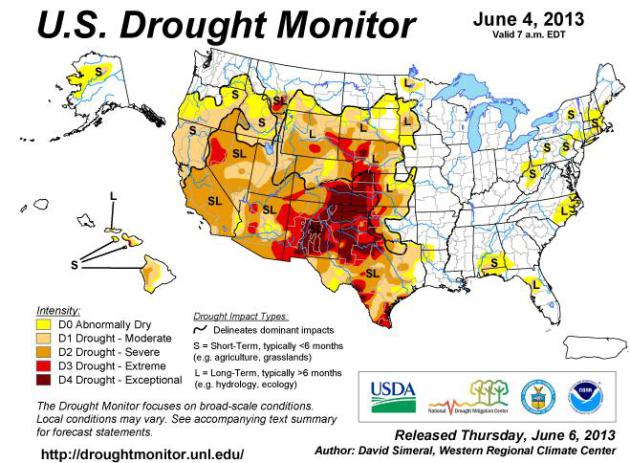
U.S. Drought Monitor
The U.S. Drought Monitor shows the worst drought conditions in deep red over the western Plains and New Mexico, while drought conditions are worsening in the Southwest.
"The South: Modest rainfall over Arkansas and Texas led to some minor improvements this week. In Arkansas, locally heavy rainfall led to the removal of an area of Abnormally Dry (D0) in northwestern Arkansas. In the Texas Panhandle, moderate rainfall this week led to improvement from Exceptional Drought (D4) to Extreme Drought (D3). Continued longer-term dryness over west Texas and north central Texas led to expansion of areas of Exceptional Drought (D4) and Extreme Drought (D3). In southeast Texas, modest rainfall totals ranging from one to two inches led to one-category improvements from Severe Drought (D2) to Moderate Drought (D1). In east Texas, locally heavy rainfall in excess of three inches helped to improve areas of Moderate Drought (D1) and Abnormally Dry (D0). Temperatures were above normal throughout the region over the past week, with exception of northern Arkansas.
The Plains: In Oklahoma, heavy rainfall and severe weather continued this week. A sharp drought gradient has been developing between the eastern and western sections of Oklahoma. According to the Oklahoma Climatological Survey, El Reno, Oklahoma (site of the EF-5 tornado on May 31), had a 30-day total rainfall accumulation of 12.65 inches while neighboring Watonga to the west had only 2.4 inches for the same period. Much of eastern Oklahoma returned to normal or near-normal conditions, while the western one-third remained dry. This week, one-category improvements were made in central, north central, and northeast Oklahoma along the eastern edge of the drought boundary. In Kansas, heavy rainfall in excess of six inches fell over the southeastern portion, leading to one-category improvements in areas of Severe Drought (D2), Moderate Drought (D1), and Abnormally Dry (D0). In south central Kansas, improvements were made in an area of Extreme Drought (D3). Mirroring Oklahoma, the far western part of Kansas has been much drier with long-term deficits remaining, leading to a slight expansion of Exceptionally Dry (D4). In Nebraska, drought conditions eased as widespread rainfall ranging from one to five inches fell over the eastern two-thirds of the state. One-category improvements were made in areas Exceptional Drought (D4), Extreme Drought (D3), Severe Drought (D2), Moderate Drought (D1), and Abnormally Dry (D0). In South Dakota, heavy rainfall this week (two to seven inches) led to widespread one-category improvements in the northwestern quarter of the state. Temperatures throughout the region were below normal over the past week.
The West: During the last seven-day period, most of the West was generally dry, with the exception of Montana and northern Wyoming. Widespread heavy rain fell over the eastern half of Montana and the northeast quarter of Wyoming, helping to significantly improve drought conditions. Some areas of central and eastern Montana received over eight inches of rain, leading to one- and two-category improvements in southeastern Montana. The combination of recent rainfall and near-normal winter precipitation led to one-category improvements across northern Wyoming, including the removal of an area of Extreme Drought (D3) along the Wyoming-Montana border. Conditions continued to deteriorate over southern Idaho, the northern Great Basin, and southeastern Oregon as a result of below-normal precipitation throughout the winter and spring months. One-category degradations were made in these areas. In California, below-normal precipitation for the Water Year (starting October 1) and wildfire-related impacts led to the expansion of areas of Severe Drought (D2) in southern California as well as central California. Currently, the Powerhouse fire in southern California has charred over 32,000 acres, marking an early start to the wildfire season in the California. In the Four Corners region, a new area of Extreme Drought (D3) was introduced in response to below-normal precipitation throughout the winter and spring months."
See more from the U.S. Drought Monitor HERE:
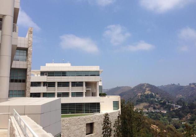
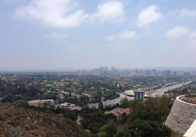
Los Angeles
Since the first of the year, Los Angeles International Airport has only seen 2.61" of rainfall since January 1st. 2013 has been very dry for folks in the western part of the country. LAX airport is nearly 6" below normal precipitation since January 1st. Thanks to Paul Douglas for the pictures below from LA.
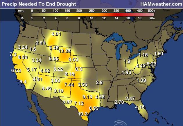
Precipitation Needed to End Drought
Take a look at how much precipitation is needed to end the drought out west! Some spots need over 12" to end the drought!
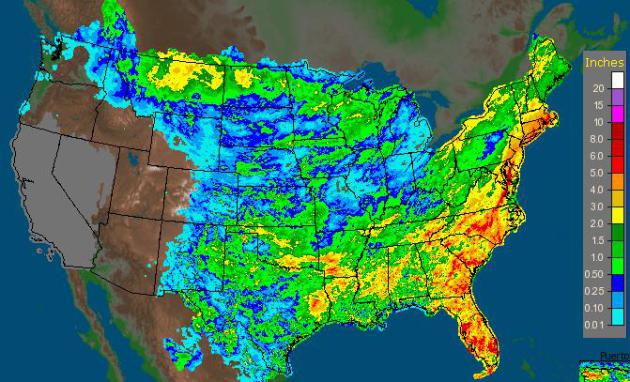
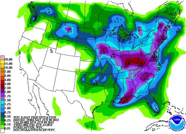
5 Day Precipitation
NOAA's HPC 5 day precipitation forecast suggests more rain for folks in the eastern half of the country vs. in the western half of the country.
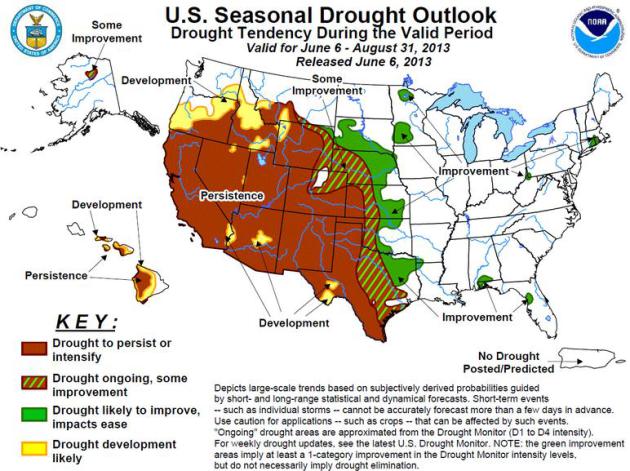
Drought Oulook
Unfortunately, it looks like drought conditions will persist in the Southwest, while some improvement will be found in the Plains.
"Latest Seasonal Assessment - During the past three weeks (since May 16), an active weather pattern, consisting of a series of slow-moving storm systems tracking across the northern tier of the Nation, brought ample rainfall to the Pacific Northwest, the northern thirds of the Rockies and High Plains, much of the Great Plains, Midwest, Delta, Great Lakes Region, New England, and southern half of Florida. 3-week temperatures have averaged below normal in the Northwest , northern Rockies and Plains, and upper Midwest. Since May 1, the heaviest rains (more than 7 inches) have fallen on parts of the northern High Plains, the middle Mississippi Valley, central Great Plains, the upper and lower Delta, parts of Florida, and the southern Appalachians. In contrast, drier conditions were observed in the Southwest, the southern Rockies and High Plains, portions of the Southeast, especially Alabama, the eastern Ohio Valley, and the mid-Atlantic."
See more on the U.S. Seasonal Drought Outlook HERE:
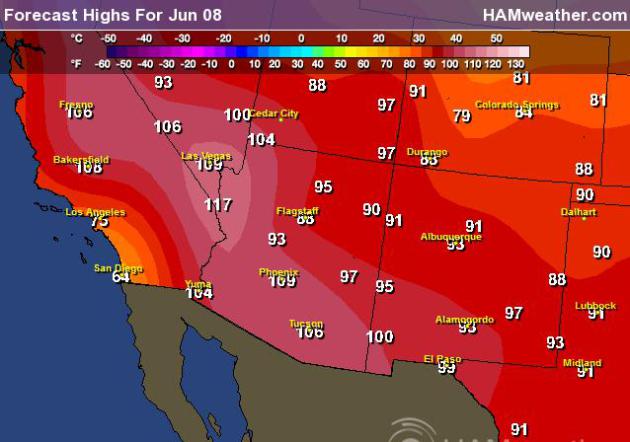
More Excessive Heat
The National Weather Service continues EXCESSIVE HEAT WARNING for parts of the Desert Southwest through PM Sunday. High temperatures will top out in the 110s to 120s again on Sunday and will likely stick in the 100s to 110s through much of next week! WHEW!

Sunday High Temps
Thanks for checking in, have a great rest of your weekend
Don't forget to follow me on Twitter @TNelsonWNTV

No comments:
Post a Comment