82 F. average high on June 24.
84 F. high on June 24, 2012.
Showers and T-storms (some heavy to severe) into Wednesday night.
Basically dry Thursday into Saturday with a drop in temperature and dew point.

Jungles of Minnesota
Here's a vaguely personal question: do you have
Doppler in your pocket? I'm not trying to insult you or sell you
anything. I'm talking about the ability to call up radar and warning
maps on your smart phone. We're not always in front of TV's or computer
screens, but with the right app there's no reason to be surprised by a
sudden tantrum from Mother Nature.
With the exception of Dakota county, outdoor
sirens aren't sounded for severe thunderstorm warnings. And yet Friday's
storms were historic, impacting far more Minnesotans than most
tornadoes or even floods. The day is coming (soon) when we will each
have our own personal warning systems (TV at home - smartphone enabled
while mobile). The government won't save us - we need to take personal
responsibility for our safety, and the safety of our families.
Severe storms bubble up again today &
Wednesday, but sunnier, drier, less humid weather arrives Thursday into
much of the weekend. Cool air aloft may set off PM clouds and showers by
Sunday afternoon. Models show a cooling trend; 70s in time for the 4th
of July?
And yes, it's a minor meteorological miracle
that nobody was injured or killed during Friday evening's hurricane-like
winds. We were very, very lucky.
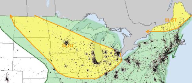
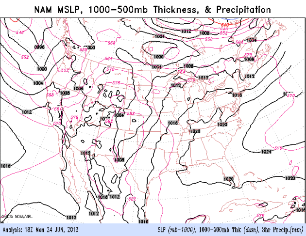
Tuesday Severe Threat.
There's a slight risk of large hail and damaging winds from the Dakotas
and much of Minnesota to Des Moines, Chicago and Detroit, another
region that needs to be monitored over northern New England. Map: SPC.
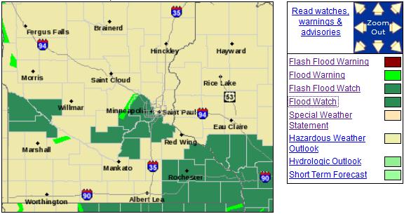
Flood Watches And Warnings. With recent heavy rains the local NWS office
is upgrading some watches to warnings. If you live along a flood-prone
river or stream you'll want to pay attention in the coming days. Here's
the latest Flood Watch:
...THE FLOOD WATCH HAS BEEN UPGRADED TO A RIVER FLOOD WARNING
FOR THE FOLLOWING RIVERS IN MINNESOTA...

  SOUTH FORK CROW RIVER AT DELANO AFFECTING WRIGHT COUNTY
  CROW RIVER AT ROCKFORD AFFECTING HENNEPIN AND WRIGHT COUNTIES

...THE NATIONAL WEATHER SERVICE IN CHANHASSEN HAS ISSUED A FLOOD
WATCH FOR THE FOLLOWING RIVERS IN MINNESOTA...

  MINNESOTA RIVER AT MONTEVIDEO AFFECTING CHIPPEWA...LAC QUI PARLE
  AND YELLOW MEDICINE COUNTIES
  MINNESOTA RIVER AT HENDERSON AFFECTING LE SUEUR...SCOTT AND SIBLEY
  COUNTIES
  MINNESOTA RIVER NEAR JORDAN AFFECTING CARVER AND SCOTT COUNTIES
  MINNESOTA RIVER AT SAVAGE AFFECTING DAKOTA...HENNEPIN AND SCOTT
  COUNTIES

.THIS RIVER FORECAST IS BASED ON THE RAINFALL THAT HAS OCCURRED
OVER THE PAST FEW DAYS. ON AVERAGE WIDESPREAD 2 TO 4 INCHES
WITH LOCALIZED AMOUNTS OF 6+ INCHES HAS FALLEN ACROSS THE
MINNESOTA RIVER VALLEY. ANOTHER ROUND OF STORMS WILL FORM THIS
AFTERNOON AND INTO TONIGHT. RAINFALL AMOUNTS THROUGH 7 AM TUESDAY
WILL AVERAGE BETWEEN 0.75 AND 1.25 INCHES. IN ADDITION...WE ARE
EXPECTING ANOTHER ROUND OF STORMS DURING THE DAY ON TUESDAY AND INTO
TUESDAY NIGHT. THE FORECAST RAINFALL WITH THE ACTIVITY EXPECTED
TUESDAY AFTERNOON AND TUESDAY NIGHT HAS NOT BEEN INCLUDED IN THE
FORECASTS. SO THE ADDITIONAL RAINS COULD CAUSE RIVER LEVELS TO RISE
EVEN HIGHER THAN PREDICTED.

GIVEN THE UNCERTAINTY IN THE RAINFALL FORECAST FOR TODAY AND
TUESDAY...THERE IS STILL SOME UNCERTAINTY TO THE RIVER
FORECASTS AND WHETHER OR NOT LOCATIONS WILL REACH FLOOD STAGE.
AS CONFIDENCE INCREASES ON THE FORECASTS AND THE POTENTIAL FOR
FLOODING...FUTURE WARNINGS MAY BE ISSUED.
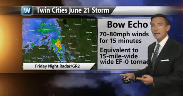
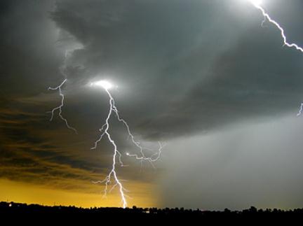
Lessons Learned From The June 21 Mega-Storm. Last Friday evening's bow echo, severe winds and flooding rains were a subtle (yet blunt) reminder that damage from severe thunderstorms can be even more extensive than a tornado touch-down. The latest edition of Climate Matters is here: "It wasn't a tornado, but hurricane force winds combined with a saturated ground that led to widespread damage and the largest power outage in Minnesota's history. Friday night's storm was the equivalent of a 15-mile-wide EF-0 tornado, and WeatherNation Chief Meteorologist Paul Douglas says it serves as a reminder that you need to take severe thunderstorms seriously."
Extra Severe.
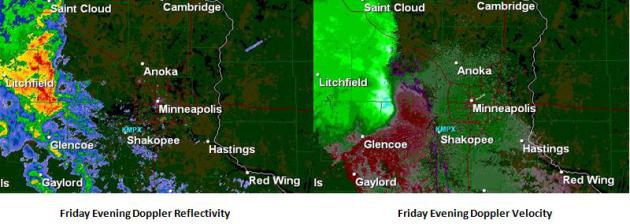
Imagery above from Friday evening's bow echo; reflectivity upper left
showing rain and hail, radial velocity upper right shows a severe gust
front as rain and hail-cooled air rushed east at 50 mph. A few thoughts
from Friday's severe gust front:
* Sirens are not sounded for Severe Storm Warnings (with the exception of Dakota County).
* Tornadoes get more attention,
but severe storms can be just as destructive. Damage is often more
extensive, but not as severe as in a major tornado. To put things into
perspective, the damage left behind from Friday's 70-80 mph gust front
was roughly equivalent to an EF-0 tornado, one that was 15-20 miles
wide.
* The supercell thunderstorm
that morphed into a bow echo raced east at 50 mph, moving faster than
the high-res models were suggesting. Winds gusted close to hurricane
force across much of Hennepin County for 10-15 minutes. The persistence
of the high winds, coupled with wet, saturated ground from early morning
storms, helped to bring down even more trees.
* This rotating supercell was
able to sustain itself, keeping the rain and hail-cooled gust front
intact for several hours, prolonging the damage. A typical thunderstorm
self-destructs after 30-45 minutes, but spinning supercells can protect
the warm updraft, sustaining a storm for a long period of time.
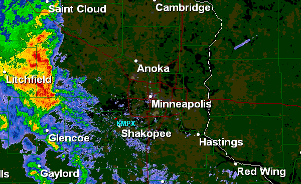
Bow Echo. Click to activate loop. Here is a loop (GR2) of the severe thunderstorm that swept across the metro area Friday evening, becoming more severe as it pushed east of Lake Minnetonka toward South Minneapolis, whipping up a 70-80 mph gust front in the process.
Thundery Holding Pattern. Once again weather systems are creeping eastward across the USA, showers and T-storms, some strong to severe, will continue to flare up from the Midwest into the Great Lakes and New England. The southwest remains dry - nothing brewing in the tropics thru the 4th of July.
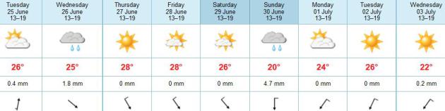
3 Dry Days In A Row? Don't get your hopes up too high. Our track record isn't very promising as of late, when storms and fronts seem to be spaced about 24 hours apart. Showers and T-storms linger into Wednesday, but ECMWF data (and other models) confirm a mostly-dry spell from Thursday into Saturday; probably the nicer, drier day of the weekend. A few showers are possible Sunday, temperatures on the cool side of average into the 4th of July holiday weekend. No big heat spikes for the 4th? Tell me you're really surprised.
(photo: littleleague.org)
"With the recent spate of severe and damaging
thunderstorms impacting the metro area, I wanted to drop you a quick
note and remind you and your colleagues that lightning-related
fatalities are most likely at the very beginning and tail-end of an
outdoor event. This is where we see the most lightning-related injuries
and fatalities, not during the height of the storm, when heavy rain/hail
is falling.
Here’s the problem: lightning can travel 8-10 miles
in a horizontal direction. In fact every year people are struck with
blue sky overhead, a thunderstorm on the distant horizon. The National
Weather Service’s “30-30 Rule” has become a defacto standard in the
weather business. When you can count 30 seconds between lightning and
thunder it’s time to head for shelter; and wait 30 minutes after the last thunderclap before resuming safe play on the field.
From a National Weather Service link focused on Lightning Safety and Outdoor Sports Activities:
“Because
electrical charges can linger in clouds after a thunderstorm has passed,
experts agree that people should wait at least 30 minutes after the
storm before resuming activities”.
More information from NOAA here: http://www.srh.noaa.gov/jetstream/lightning/lightning_safety.htm
I realize the wet spring has compressed the season,
and players (and their parents) are anxious to get these games in and
complete the season. However the overriding goal should be safe play and
lowering weather risk. Any temptation to “push the weather” and get
coaches, players (and spectators) out onto a ball field within 30
minutes of the last report of thunder is not only unsafe, but a
potential disaster in the making. From a litigation standpoint, there’s a
large and growing body of evidence that waiting 30 minutes
significantly increases safety margins and helps to avoid
lightning-related disasters. Taking a chance and resuming play within
that 30 minute window is a recipe for fatalities, life-long, chronic,
lightning-related injuries, and litigation.
As an interested parent who spent many long
weekends at the local ballpark with my two son (checking Doppler on my
smart phone more often than I would have liked) I have an interest in
safe play and taking any and all steps to reduce the potential for
weather-related tragedy."
- Paul Douglas, CBM Meteorologist. Founder of Media Logic Group.
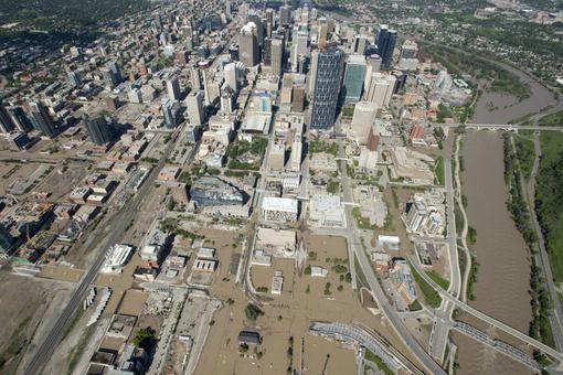
Photo credit above: "A flooded downtown
Calgary, Alberta is seen from a aerial view of the city Saturday, June
22, 2013. The two rivers that converge on the western Canadian city of
Calgary are receding Saturday after floods devastated much of southern
Alberta province, causing at least three deaths and forcing thousands
to evacuate." (AP Photo/The Canadian Press, Jonathan Hayward)

TODAY: Steamy, risk of a few severe T-storms. Dew point: 72. High: 87
TUESDAY NIGHT: T-storms, locally heavy rain capable of minor flooding. Low: 73
WEDNESDAY: Still tropical. More numerous showers and T-storms. Dew point: 73. High: 86
THURSDAY: Warm sun, probably dry with a drop in humidity. Dew point: 66. Wake-up: 72. High: 89
FRIDAY: Clouds & sun, less humid. Dew point: 63. Wake-up: 69. High: 83
SATURDAY: Partly sunny, late PM showers far north. Wake-up: 65. High: near 80
SUNDAY: Sunny start, then midday clouds, few PM showers? Wake-up: 64. High: 75
MONDAY: Intervals of sun, drier again. Wake-up: 59. High: 79
Climate Stories...
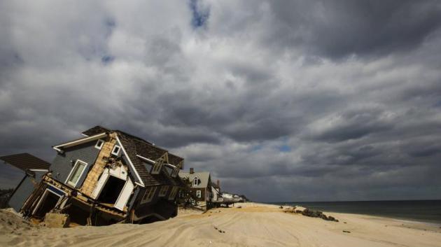
Photo credit above: "Mantoloking, New Jersey on March 22, 2013." Reuters/Lucas Jackson.
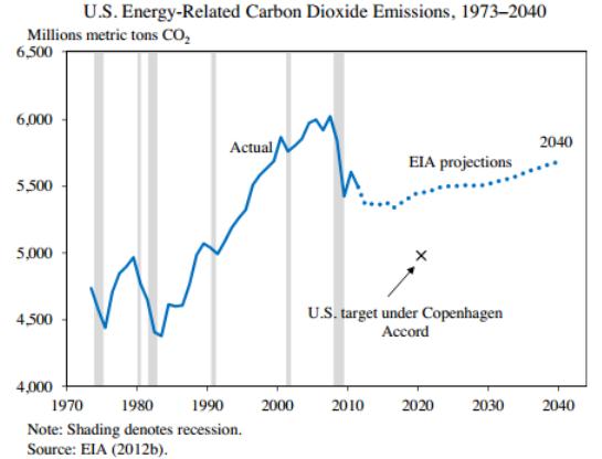

1. Power plant clampdown
All eyes are on EPA, the federal agency in charge of writing and implementing what are likely to be some of the most controversial regulations in the president’s second term: limiting carbon emissions from both new and existing power plants. Heather Zichal, the White House energy adviser, suggested Wednesday that EPA is committed to moving forward with climate regulations for power plants, particularly from the fleet of coal-fired plants that have traditionally provided the bulk of the country’s electricity. Power plants are the biggest source of U.S. carbon emissions..."
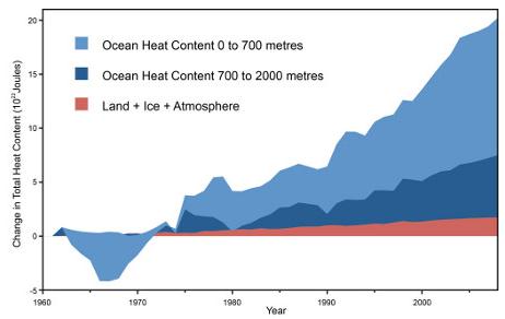
Graphic credit: "Global heat accumulation from Nuccitelli et al. (2012)".
Albertans have also learned that climate change delivers two extremes: more water when you don’t need it, and not enough water when you do. The geographically challenged have also become learned, once again, that water travels down hill and even inundates flood plains.
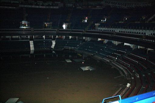
So climate change is not a mirage. Nor is it weird science or tomorrow’s news. It is now part of the flow of daily life."Photo credit: "This undated photo provided by the Calgary Flames shows the inside of the Calgary Saddledome in Calgary, Alberta. The Saddledome, home to the National Hockey League's Calgary Flames, was flooded up to the 10th row, leaving the dressing rooms submerged. The two rivers that converge on the western Canadian city of Calgary are receding Saturday, June 22, 2013 after floods devastated much of southern Alberta province, causing at least three deaths and forcing thousands to evacuate." (AP Photo/Calgary Flames).
Weather alerts should really be on the lookout for these sudden bursts of violent weather, especially if the area involved is prone to the nastier types such as tornadoes and heavy flooding. That way, people can evacuate earlier or prepare to reinforce their house beforehand.
ReplyDeleteLino @ Arrys Roofing