50 F. record low for Sunday, July 28, set in 1981. We will come close.
15 F. temperatures will average 15 F. cooler than normal today.
Sunday still looks like the nicer, sunnier, milder day of the weekend.
72 F. high in the Twin Cities Friday.
83 F. average high for July 26.
84 F. high on July 26, 2012.
.01" rain fell in the Twin Cities yesterday.
July Wind Chill (doing a calendar double-take)
Here's a horrific bit of weather trivia: July is
the only month where snow hasn't been reported at an official Minnesota
reporting station. The city elders don't like to share that fun nugget.
Roger Kormendy from Prior Lake writes "So for a
few days our weather is being influenced by “Canadian Air” as
meteorologists around here and probably across the country refer to. My
question is, do Canadian meteorologists refer to air invading from the
south as “American Air”? Great question. We could use some lukewarm
American Air right now.
Forget about glancing blows of fresh air. We're
talking CANADIAN OCCUPATION here; a "cut-off" low - a swirl of unusually
chilly air breaking off from the main belt of westerlies. Typical for
October, but late July? Not so much. I'm predicting a few 30s tonight up
in Tower & Embarrass, the Twin Towns of Cold.
After a brisk, bracing, invigorating start
(buying any of this weather-spin?) clouds build this afternoon. A stiff
wind means only the brave & foolish will be in the water. Sunday
looks sunnier; a notch milder. You'll only need 2 T-shirts instead of 4.
Deep breaths.
80s return the latter half of next week - but not a 90 in sight.
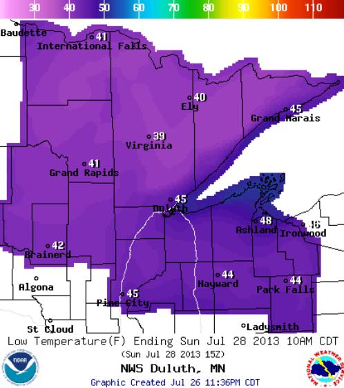
30s Sunday Morning Minnesota Arrowhead.
If skies clear and winds ease a bit temperatures will drop into the 30s
over Minnesota's Arrowhead late tonight, maybe mid-30s Embarrass and
Tower. Map above: NOAA.
Warming Trend Next Week. No
worries - think of this as a mid-summer intermission from heat and
humidity. Although no searing heat is brewing anytime soon we will see a
rerun of 80s by the middle of next week. The best chance of showers and
T-storms: Tuesday, again Friday of next week.
Short-Term Chill; Longer-Term Warm Bias? In spite of
the chill outside your window today some of the longer range models are
showing a warm bias for autumn, continuing the recent trend of
(milder) falls across Minnesota and the Upper Midwest. In today's
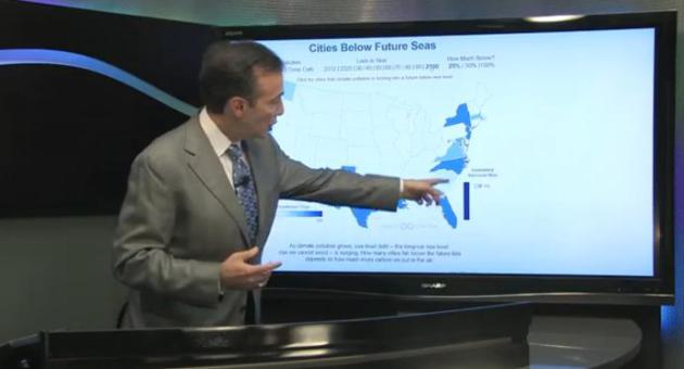
edition of
Climate Matters
we update Dorian, Flossie (which sounds like a bunny rabbit), and the
implications of a buckling of the jet stream into a very strange, almost
unheard-of July "cut-off" low.
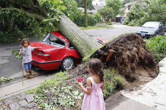
Obama Signs Disaster Declaration For Counties Hit By Solstice Storm.
City Pages has the details; here's an excerpt: "
Last
week, both members of congress -- along with Gov. Mark Dayton, Sens.
Amy Klobuchar and Al Franken, and four other U.S. reps -- asked President Barack Obama
to issue a disaster declaration for the 18 counties in Minnesota
hardest-hit by the solstice storms. Yesterday, he did. The presidential
signature means that now, the feds can step in with more funds to help
clean-up and rebuild infrastructure and public property. Preliminary
assessments peg the tab for recovery at $17.8 million, a good $10
million higher than initial estimates..."
Photo credit:
Herbert Stellner III
Unusual Tornado On July 22. I thought this was especially interesting, an excerpt of Dr. Mark Seeley's always-excellent
WeatherTalk Newsletter: "
The
NOAA-National Weather Service Grand Forks Office reported on an
unusual tornado earlier this week that struck between Mahnomen and
Zerkel (Mahnomen County). This storm was unusual in several aspects:
firstly it struck between 1:50 AM and 2:30 AM on July 22nd (Monday), a
very rare time of day for tornadoes in our region (less than 2 percent
of all tornadoes occur at that time of day); second, wind speeds were
estimated to range from 110-120 mph (EF-2 strength), unusually strong
for an overnight storm; thirdly, the storm path was nearly 18 miles in
length (though intermittently on the ground), a relatively long storm
path for an overnight storm. Thankfully this tornado did not cause any
deaths or injuries, but it did damage a home, a number of farm
structures, along with some farm equipment. It also caused a good deal
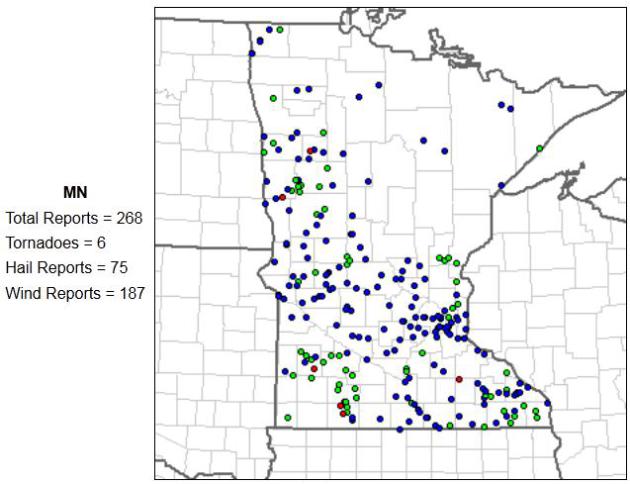
of tree damage, especially around Roy Lake. This was the 6th confirmed
tornado of the year so far in Minnesota. You can read more about the
2013 tornado season in Minnesota at the MN State Climatology Office web
site.....
http://www.climate.umn.edu/doc/journal/Tornado2013.htm
Map above:
SPC reports only 6 tornadoes in Minnesota so far in 2013.
Thought For The Day...
"So for a few days, our weather is being influenced
by “Canadian Air” as meteorologists around here and probably across the
country refer to it as. My question is, do Canadian meteorologists
refer to air invading from the south as “American Air”?
Roger Kormendy
Prior Lake
It's 90 Degrees In Siberia And People Are Sunbathing. Even more incredible, there's a publication called the "Siberian Times". Who knew?
The Atlantic Wire has more details
:
"Your mental image of Siberia is probably a snowy, wind-whipped
expanse, perhaps with a cluster of buildings to house those banished
from Russian society. Not this week. This week, Norilsk, the
northernmost large city in the world, the second largest city north of
the Arctic Circle, and the site of one of those gulags, hit a balmy 32
degrees Celsius — about 90 Fahrenheit. It's normally in the mid-60s. The
online outlet The Siberian Times ("up-to-date information in English
from across Siberia's six time zones") featured a photo of people
sunbathing on the shores of Lake Baikal in its report on what may be a new record high..."
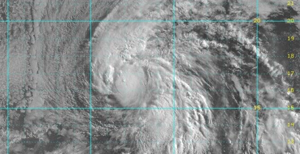
Here's what we're monitoring:
* Tropical Storm Dorian
has weakened over the last 24 hours, packing 50 mph sustained winds.
It's running into drier air with increasing wind shear, preventing the
storm from strengthening to hurricane status for at least the next 4-5
days as it pushes toward Cuba.
* Tropical Storm Flossie
expected to weaken into a tropical depression before drifting over
Hawaii; capable of torrential rains and significant flooding by Tuesday
of next week.
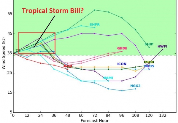
Dorian: An Unimpressive Tropical Storm.
A combination of dry air becoming entrained in its circulation and
increasing wind shear is causing Dorian to weaken, a trend which is
expected to continue into the weekend, in fact Dorian may lose tropical
storm strength. That doesn't mean we can discount the storm altogether.
Wind shear is forecast to weaken slightly as it approaches the
Caribbean, and with the storm moving into an area of warmer sea surface
temperatures some strengthening is still possible next week.
Latest Numbers.
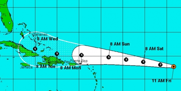
T.S. Dorian is moving briskly toward the west-northewst, on a track
which should still take the storm north of St. Martin, The U.S. Virgin
Islands and Puerto Rico by Sunday. Heavy rain squalls are possible from
St. John to San Juan, but the core of the storm should stay 50-150 miles
north of the islands. More serious flooding is possible Monday and
Tuesday as the storm brushes Haiti and the Dominican Republic.
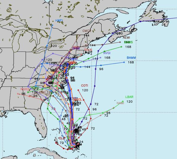
Short-Term Track: High Confidence.
The models are (amazingly) aligned, showing the track of Dorian over
the next 5 days, posing the greatest risk to the southern Bahamas and
Cuba in a Monday-Tuesday time frame next week.
Long-Term Track: Low Confidence.
After pushing near Cuba by Monday or Tuesday, the models are
(literally) all over the map with where Dorian may go next. An
increasing number of solutions take Dorian into the Gulf of Mexico,
which would probably be the most threatening solution for the U.S. Water
temperatures are unusually warm in the Gulf, and Dorian might
strengthen significantly if it takes a more southerly rouute. Just as
many models veer the storm to the north, possibly soaking Florida with
heavy rains the middle or end of next week before pushing out into the
Atlantic. Confidence levels are still very low regarding the long-term
path of Dorian, and even whether this storm poses a significant risk to
facilities in the U.S.
Sputtering Along.
The combination of dry air and wind shear will probably conspire to
keep Dorian a modest tropical storm, at least looking out 120 hours. A
few of the models even weaken Dorian to a tropical depression or
tropical wave beyond 60 hours, a scenario which is very believable
looking at the data.
Timing Dorian.
Based on guidance from NOAA NHC Monday looks like the wettest day for
Puerto Rico; minor flooding can't be ruled out, but right now this does
not look like a significant/deadly storm scenario. More serious flooding
is possible from The Domincan Republic to Cuba and the Bahamas by
Tuesday and Wednesday of next week.
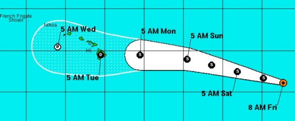
A Hawaiian Soaking.
Tropical Storm Flossie is expected to weaken as it pushes westward
across the Pacific, reaching tropical depression strength before
impacting the Hawaiian Islands in a Tuesday-Wednesday timeframe next
week. Soaking/flooding rains and subsequent flash flooding can't be
ruled out in Honolulu by the middle of next week.
Summary: our goal
is to set expectations, and although Dorian is fairly unimpressive
(today) we need to continue to collectively monitor this storm, and
possible implications for the U.S. Florida stands the best chance of
soaking rains from Dorian by the middle of next week; a solution that
brings Dorian into the Gulf of Mexico could threaten much of the Gulf
Coast with a much more significant storm or possible hurricane. Again,
it's too early to make a long-term determination of impacts or possible
U.S. landfall at this time. Flossie will probably spark considerable
flash flooding over Hawaii by Tuesday-Wednesday of next week. I'm
tempted to get on a plane and personally coordinate preparation efforts
on Waikiki Beach, but - alas - there's a high probability that won't
happen. I'll keep you in the loop with updates - hopefully Dorian's
long-term track will emerge from the meteorological noise within the
next 48-72 hours.
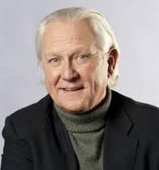
Ex-WCCO Anchor Don Shelby Mulling A Run For Congress. Hot Dish Politics at
The Star Tribune has the story - here's an excerpt: "
Former
WCCO news anchor Don Shelby is reportedly mulling a run against
three-term Republican Rep. Erik Paulsen next year, potentially putting
in play a suburban Minneapolis
congressional district that has been in Republican hands for decades.
Shelby’s interest burst into the open amid remarks by U.S. Rep. Collin
Peterson, D-Minn., who mentioned it at a Washington fundraiser
Wednesday attended by about 30 or 40 campaign contributors, lobbyists
and Democratic activists. Peterson’s account of Shelby’s interest was
confirmed by two prominent Minnesota lobbyists who were at the
luncheon. Both said Peterson described Shelby’s long career in
Minnesota broadcast journalism...."
Drinking Coffee May Reduce Risk Of Suicide In Adults. Another eyebrow-raising article; here's an excerpt from The
Harvard School of Public Health: "
Drinking
several cups of coffee daily appears to reduce the risk of suicide in
men and women by about 50%, according to a new study by Harvard School
of Public Health (HSPH) researchers. The study
was published online July 2, 2013, in The World Journal of Biological
Psychiatry. “Unlike previous investigations, we were able to assess
association of consumption of caffeinated and non-caffeinated
beverages, and we identify caffeine as the most likely candidate of any
putative protective effect of coffee,” said lead researcher Michel Lucas, research fellow in the Department of Nutrition at HSPH..."
Cancer Risk Increases With Height. Here's a clip from the "Well" blog at
The New York Times: "
A
woman’s cancer risk appears to increase with her height, a new study
shows. An analysis of 20,928 postmenopausal women showed that the taller
a woman is, the greater her risk for a number of cancers, including
breast, colon and skin cancer, among others. The finding,
published in Cancer Epidemiology, Biomarkers & Prevention, is not
expected to change screening recommendations and shouldn’t alarm those
with a tall stature. Instead, say scientists, the association between
height and cancer may help guide researchers to study hormones and
growth factors that influence height and may also play a role in cancer..."
A Year Of Sky On Earth. This is a great Vimeo video, courtesty of
NASA's Astronomy Picture Of The Day; here's a description: "
Each panel shows one day. With 360 movie panels, the sky over (almost) an entire year is shown in time lapse format as recorded by a video camera on the roof of the Exploratorium museum in San Francisco, California. The camera recorded an image every 10 seconds from before sunrise to after sunset and from mid-2009 to mid-2010. A time stamp showing the local time of day is provided on the lower right. The videos
are arranged chronologically, with July 28 shown on the upper left, and
January 1 located about about half way down. Although every day lasts
24 hours, daylight lasts longest
in the northern hemisphere in June and the surrounding summer months, a
fact which can be seen here as the bottom (and soon top) videos are
the first to light up with dawn..."
Which U.S. City Has The Worst Drivers? O.K. Boston
would get my vote, and I've heard some crazy stories from my father
about driving in Detroit (at least in a German-built vehicle). The
answer didn't surprise me too much, come to think of it.
Slate has the cautionary tale - here's an excerpt : "...
Still,
the Allstate report is both a useful indicator and a good way to
winnow down the candidates. We can safely assume that the city with the
worst drivers is somewhere in Allstate’s bottom 50. Phoenix,
Indianapolis, and Denver, therefore, are off the hook, along with a raft
of others. One notable escapee is San Diego, the city with the most drunk driving arrests.
Let’s also ignore cities with populations below 150,000, because data
on those places is limited. Plus, few people have ever said, “Hayward,
California has the worst drivers!” We’ll add Boston back into the mix,
based on opinion surveys. (You’re not getting off that easy, Boston.)
That leaves 39 candidates..."
Graphic credit: Alex Eben Meyer.
"Quickboat" Foldable Boat: From Roof Rack To Water In 60 Seconds. If towing a boat is just too much trouble, now you can unfold one? I'm almost afraid to see what comes next. Gizmag.com has the details: "Think
it takes more time to build a boat than make a French omelette? Think
again. The Quickboat is the first foldable boat we've seen that a team
of two can put together in a minute or less. That's insanely fast
compared to the build times of other foldable boats we've covered, such
as the Transporter (10 minutes) and the Smartkat
(20 minutes). In fact, the boat is so easy to construct says Deryck
Graham, the Managing Director of Australian company Quickboats, that one
person with a beer in hand could assemble the boat in three minutes
even with friends around to distract them..."
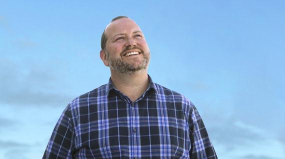
Meteorologists Reporting Sky Just A Little Bit Bluer Today, And It's Because Minneapolis Resident Doug Bramowski's In Love. A headline like this could only come from one authoritative source:
The Onion. Details: "
The
National Weather Service is reporting that the clouds over Minneapolis
have parted, the sun is shining, and the sky is just a little bluer
today—and it’s all because 38-year-old Doug Bramowski is in love,
folks. NWS meteorologists predict that since Bramowski’s head over
heels for Abby Feldman and, by golly, she’s crazy about him, too, Twin
Cities residents will be enjoying particularly beautiful weather this
weekend with highs in the mid-to-upper 70s, unusually low humidity, and
crystal-clear skies as far as the eye can see..."
Photo credit above: "With low humidity and blue skies for miles, meteorologists say ol’ Dougie Boy is most definitely in love, and it’s for real."
TODAY: Early sun, PM clouds, windy and cool. Winds: NW 10-20. Dew point: 45. High: 67
SATURDAY NIGHT: Clearing, near-record chill. Low: 48
SUNDAY: Chilly start. More sun, less wind. Winds: NW 10+ High: 72
MONDAY: Plenty of sun, turning milder. Wake-up: 55. High: 79
TUESDAY: Warm & sticky, passing T-storm. Wake-up: 61. High: near 80
WEDNESDAY: T-storms south, clearing north. Wake-up: 64. High: 82
THURSDAY: Warm sun, feels like summer. Wake-up: 65. High: 83
FRIDAY: A fine start to August. Warm sun. Wake-up: 66. High: 84
Climate Stories...
Global Warming And The Future Of Storms.
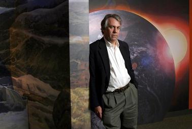
The Guardian has the story, co-authored by St. Thomas climate scientist John Abraham. Here's an excerpt: "...
I asked Dr. Emanuel to summarize the present understanding of hurricanes, and he responded with the following insights:
• The incidence of high-intensity tropical cyclones
(Safir-Simpson categories 3-5) should increase, and the amount of
rainfall in these storms should increase, upping the potential for
freshwater flooding. These changes will not necessarily occur where
tropical cyclones develop and thrive today. "Indeed," wrote Emanuel,
"it is likely that there will be decreasing activity in some places,
and increasing activity in others; models do not agree on such regional
changes."
• Though experts disagree on this point, Emanuel's work suggests
that weak events (tropical storms and Cat 1-2 storms) will become more
frequent.
• "Very little work has been done on the problem of storm size,"
wrote Emanuel, "what little research has been done suggests that storm
diameters may increase with global temperature. This can have a
profound influence on storm surges, which are the biggest killers in
tropical cyclone disasters..."
Photo credit:
Dr. Kerry Emanuel, MIT.
Desert Storm: Battle Brews Over Obama Renewable Energy Plan.
National Geographic Daily News has the story; here's the introduction: "
America's
deserts are stark, quiet places, where isolation and the elements have
long kept development at bay. To outsiders, these arid expanses may
not seem like prized land. But they are poised to play a key role—and perhaps, to serve as a battleground—in President Obama's plan to double U.S. electricity from wind, solar, and geothermal sources
by 2020. To help ramp up that amount of clean energy, the White House
has urged approval of an additional 10,000 megawatts of renewable
energy production on public lands. Estimates vary on exactly how many
households would be served by the expansion, but the Obama Administration says
the 25 utility-scale solar facilities, nine wind farms, and 11
geothermal plants it has approved on federal lands so far will provide
enough juice to power 4.4 million homes. One thing is for certain: The
new drive for large-scale solar will require land..."
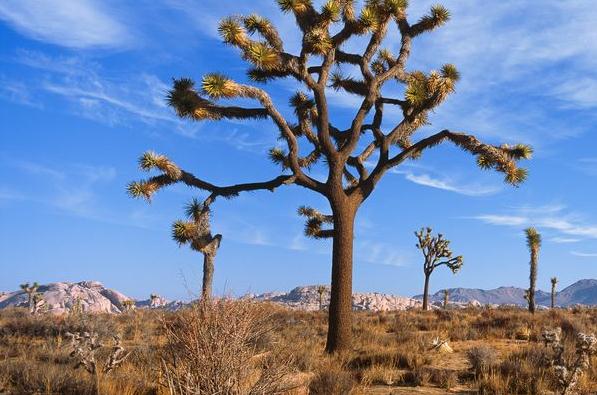
Photo credit above: "
Joshua Tree National Park soon will
share its California desert skies with a new close neighbor, a huge
solar farm. It's part of a big renewable energy drive on public land." Photograph by Bill Hatcher, National Geographic.
Fossil Fuels To Dominate World Energy Use Through 2040. Meteorologist Andrew Freedman has the story at
Climate Central; here's an excerpt: "
Global
energy consumption will grow by 56 percent by 2040 with fossil fuels
remaining dominant energy sources. Along with that growth will come
increased carbon dioxide emissions and a continued reliance on coal,
oil, and natural gas for transportation and electricity generation,
according to a new report published Thursday by the Energy Information Administration (EIA). The International Energy Outlook,
which is released every two years, shows that strong economic growth
in developing countries will be the dominant force driving world energy
markets during that period. “Rising prosperity in China and India is a
major factor in the outlook for global energy demand. These two
countries combined account for half the world’s total increase in
energy use through 2040,” said EIA administrator Adam Sieminski in a
press release. The EIA is the Department of Energy’s statistical and
analytical agency..."
Former CIA Director: Fixing The U.S. Energy Strategy. Here's a clip of an interesting Op-ed at livescience.com: "...The
key to reducing the political and economic cloud of questionable
fuel-vending nations is to reduce overall demand - and, thus, the market
price and profits - for oil. While we can't take millions of
conventional-fuel vehicles out of the U.S. fleet overnight, there may be
cheap and effective ways to accelerate the use of alternative fuels and
increase energy independence. In particular, Woolsey believes in the
potential for a market for ethanol and methanol derived from U.S.
natural gas. With the current price of natural gas sitting around
one-fifth that of oil, developing methanol-based fuels to add them as a
choice at the pump could potentially take enough demand away from oil to
drive prices down to $60 per barrel or less....
Photo credit: "A drilling rig in North Dakota near the town of Stanley. Fracking is used in this area to tap oil reserves."
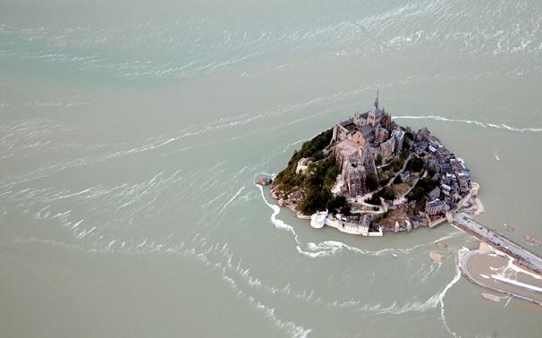
Mont St. Michel Becomes An Island For The First Time Since 1879. The story from
The Telegraph; here's a clip: "
Hundreds
of people gathered to watch the event on Wednesday evening, which only
lasted about 20 minutes, as the English Channel entirely surrounded
the Unesco world heritage site. "For the first time in a long time we
will see the sea surround the Mont," Laurent Beauvais, president of the
Basse-Normandie region, told Le Figaro. "It's rare and we're here," an
unnamed couple told Le Parisienne. "We came at the right time..."
Photo credit above: "
Mont Saint-Michel at high tide."
Photo: AFP
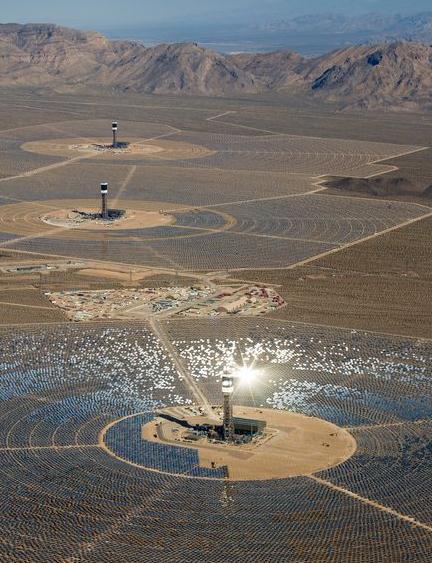
Mohave Mirrors: World's Largest Solar Energy Ready To Shine.
National Geographic has the story; here's the intro: "
More than six years in the making, the Ivanpah plant is now slated to begin generating power before summer's end. It was designed by BrightSource Energy
to use more than 170,000 mirrors to focus sunlight onto boilers
positioned atop three towers, which reach nearly 500 feet (150 meters)
into the dry desert air. The reflected sunlight heats water in the
boilers to make steam, which turns turbines to generate
electricity—enough to power more than 140,000 homes.."
Photo credit above: "
The huge Ivanpah solar plant is part
of a push to expand renewable energy on U.S. federal land. The
developer took steps to relocate a population of the endangered desert
tortoise, below." Photograph by Jim West, Alamy
Buffet Says Coal's Decline In U.S. To Be Gradual But Permanent. Bloomberg Businessweek has the story; here's the introduction: "
Coal
use in the U.S. will continue to fall though the slide will be gradual
as electric utilities switch to cleaner alternatives over “years and
years,” billionaire Warren Buffett said at an event in Indiana this
week. “Coal will gradually decline in importance, and of course when
natural gas prices get low enough you have a big switch over,” Buffett
said July 22, according to a recording posted online by WFYI, a public
radio station in Indianapolis. “Coal plants are producing about 38
percent of all the electricity in the United States now,” Buffett said.
“You can’t scrap that. That takes years and years and years to replace.
It will be happening gradually...”









No comments:
Post a Comment