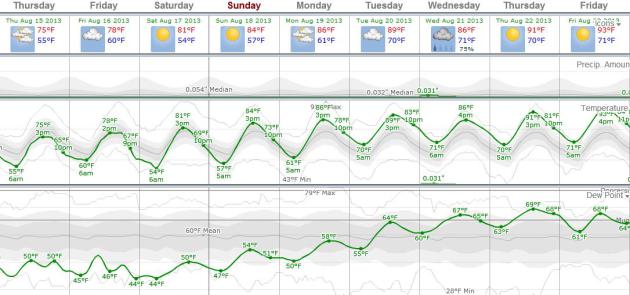
78 F. high in the Twin Cities Wednesday.
-3 F. temperatures at MSP are running 3 degrees F. cooler than average so far in August.
1.8% we've spent 1.8% more money cooling our homes and businesses since June 1, based on NWS cooling degree days.
81 F. average high on August 14.
78 F. high on August 14, 2012.
90+ heat is one week away.
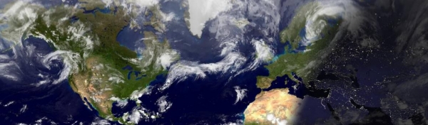
The New Abnormal
Residents of Brimson, Minnesota, just inland
from Two Harbors, woke up to a jaw-dropping low of 30F Wednesday morning
- chilliest reading in the lower 48 states. A week from now Brimson and
much of Minnesota will see highs near 90F. Remarkable.
We've always been pushed around by cold fronts
and heat spikes but the last few years have brought even steeper curves
on a global temperature roller coaster ride. The greater the temperature
swings the higher the potential for memorable storms.
Former Energy Secretary Bill Richardson writes
"Since 2011 the USA has experienced 25 extreme weather events that each
caused more than $1 billion in damages. These events contributed to the
loss of more than 1,000 lives and each American family paying $400 more
per year".
A symptom of more heat and energy in the system? Probably.
Wave goodbye to the Dog Days of September; we
heat up into the 80s this weekend - 90F possible early next week as dew
points climb into the mid 60s, up in the oh-zone. Most of us won't see
T-storms until next Wednesday. No frost, hail or hurricanes either.
We're watching the tropics; there's a risk that "Erin" may become a hurricane and track toward New Orleans.
An August To Remember. Check out the morning lows Wednesday across northeastern Minnesota, courtesy of
NOAA:
......NORTHEASTERN MINNESOTA.......

BRMM5: BRIMSON................: DHM   /     M /  30 /  0.00
COKM5: COOK...................: DH0600/    64 /  44 /  0.00
DLHM5: DULUTH NWS.............: DH0700/    69 /  44 /  0.00
EMBM5: EMBARRASS..............: DH0600/    66 /  31 /  0.00
ILIM5: ISLAND LAKE 4E.........: DH0900/    67 /  40 /  0.00
KABM5: KABETOGAMA.............: DH0700/    65 /  37 /  0.00
LEIM5: ORR 3E.................: DH0600/    63 /  35 /  0.00
Photo credit above: Imara Hixon.
Summer, The Sequel. Here's European data, courtesy of
WeatherSpark,
showing a gradual warming trend into next week, highs topping 90 next
Thursday and Friday as dew points rise into the mid and upper 60s. The
only significant chance of showers and T-storms: next Wednesday.
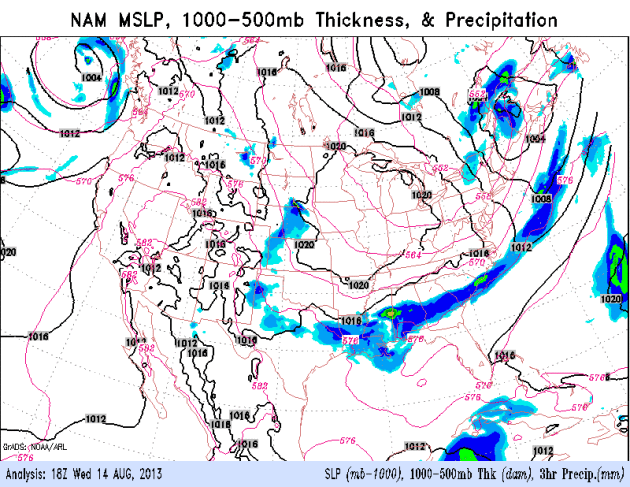
Warming Trend Central USA. The 84 hour NAM model
shows a retreating high pressure bubble turning on more of a southerly
breeze from Kansas City to the Twin Cities, meaning a slow warm-up into
the weekend. Heavy showers and T-storms linger along a stalled front
draped over the Southeast, while "Erin" crosses the Yucatan Peninsula,
pushing into the Gulf of Mexico. Loop: NOAA.
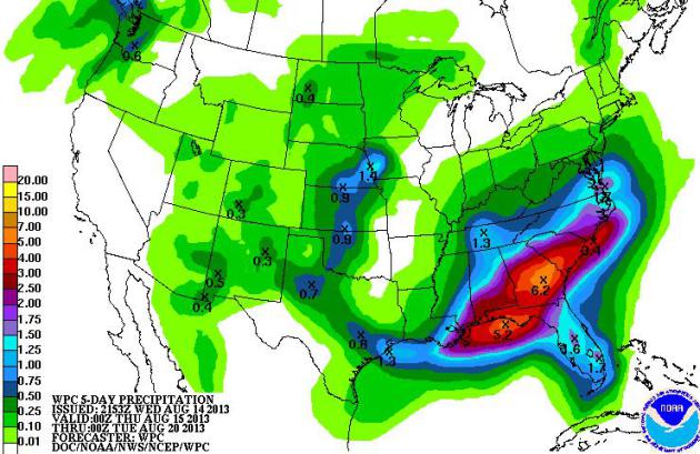
Flash Flood Potential. The 5-Day rainfall prediction
from NOAA HPC shows some 5-6" amounts from near Pensacola to Augusta
and Charleston, meaning more flash flooding over the Southeast. If
"Erin" does push toward Louisiana or Alabama some towns could see in
excess of 10-15" rain in the next week.
Growing Tropical Storm - Hurricane Potential. Here's an excerpt of an
Alerts Broadcaster briefing that went out to our corporate clients Wednesday morning:
Potential for a tropical storm or hurricane rises in the Gulf of Mexico. It's still too early for specifics regarding timing,
track and intensity, but facilities and staff from Florida to Texas
should be on a heightened state of alert. But it's not too early to take
early precautions from Brownsville and Corpus Christi to Houston, New
Orleans, Mobile and Pensacola.
An Early Look At "Erin"?
The tropical wave on the latest visible satellite is still
disorganized, but conditions over the Gulf of Mexico remain favorable
for strengthening later this week (little wind shear aloft, warming
water temperatures), and there is now a strong likelihood that this
disturbance will strengthen into Tropical Storm Erin by Saturday.
Heating Up In The Tropics.
NOAA NHC now believes there is a 50% risk that the disturbance south of
Cuba will strengthen to tropical storm force in the coming days, up
from 10% Tuesday morning. There's an even higher probability (60%) that a
tropical wave just off the coast of Africa will become a tropical
storm. We are heading into a much busier cycle for tropical storm and hurricane potential in the coming weeks. (note: as of late last night the probability of tropical storm formation in the Gulf of Mexico over the next 48 hours has risen to 70%)
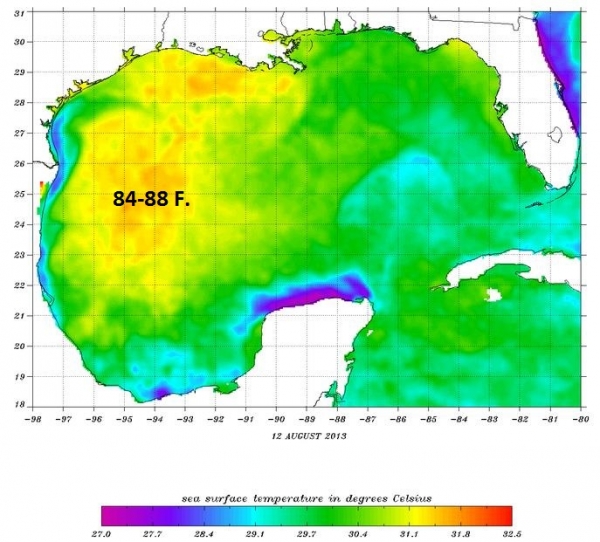
Mitigating Factor.
Water temperatures in the western Gulf of Mexico are unusually warm, as
high as 84-88 F, the rough meteorological equivalent of bathwater. The
warmer the water, the greater the potential for intensification. This is
why a more westward track is problematic, hinting at a stronger
tropical storm or hurricane by early next week.
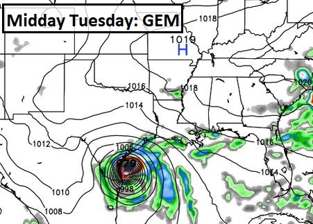
Worst Case Scenario.
Here's the solution that has me tossing and turning in my sleep, one
I'm not buying just yet. The Canadian GEM model, which was the first to
hint at a significant storm in the Gulf of Mexico yesterday, is bringing
a Category 3+ hurricane into coastal Texas by Tuesday of next week. My
confidence level is still very low that this precise track/intensity
will become reality, but we can't entirely dismiss this solution. We
receive 4 model updates/day, and we run our own internal models,
searching for continuity and alignment between models, and searching for
trends from run to run. This is why it's important that staff remain
alert and begin reviewing hurricane protocols, especially from
Brownsville and Corpus Christi to New Orleans and Mobile.
Latest (12z Wednesday) model runs increase the potential
for a tropical storm or hurricane to impact the Gulf Coast this weekend.
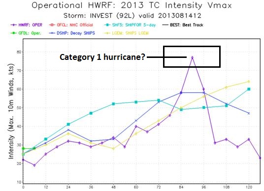
The most reliable model (HWRF) brings a minimal, Category 1 hurricane
into New Orleans and Mobile, but confidence levels on this track are still low, a 2 out of 10.
The previous run of the HWRF suggested a possible Texas landfall early
next week, so even the most accurate/reliable models are still highly
erratic. That said, we
are encouraging our clients with Gulf Coast exposure to review
hurricane response plans and prepare to activate those plans within
24-48 hours.
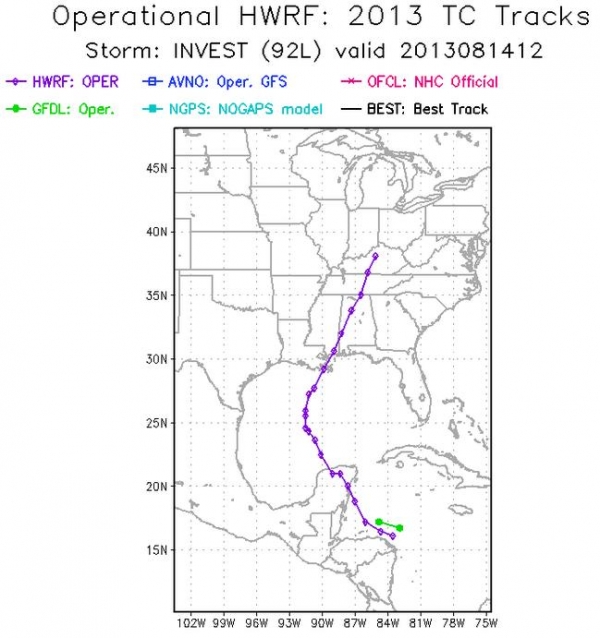
Latest Forecast Track.
The 12z run of NOAA's HWRF model brings "Erin" near Cancun, before
strengthening over the Gulf of Mexico Thursday and Friday, with a
potential track toward New Orleans, Mobile, even Pensacola. Again, track
confidence levels are still low: a 2 on a scale from 1-10. Keep in mind the greatest wind/water damage occurs to the right (east) of where the center of the storm comes ashore.
Potential For Intensification to Hurricane Strength.
The same HWRF model shows Erin coming ashore as a minimal, Category 1
hurricane within 84-96 hours. The big unknown: how unusually warm (84-87
F) water temperatures in the Gulf of Mexico may impact intensification.
It's still too early for specificity. If
Erin arrives as Category 1 storm it would generate a 4-7 foot storm
surge, capable of moderate to significant coastal flooding and beach
erosion, especially if the storm comes ashore close to high tide.
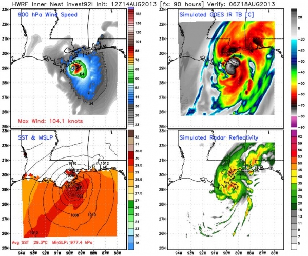
Midnight Saturday Night.
Here is a breakout of expected wind speeds (upper left), central
pressure (lower left), simulated clouds (upper right) and future radar
(lower right) from the HWRF model, valid around midnight Saturday night.
The latest solutions shows the highest winds (gusts over 100 mph)
impacting the Mississippi Delta of Louisiana, but sparing metro New
Orleans. The big unknown is storm surge potential, but if Erin does come
ashore as a Category 1-2 hurricane the retrofitted levees surrounding
New Orleans should hold. Coastal flooding might be more significant from
Bay St. Louis and Gulfport to Biloxi, Pascagoula and Mobile, as much as
4-8 feet above normal high tide.
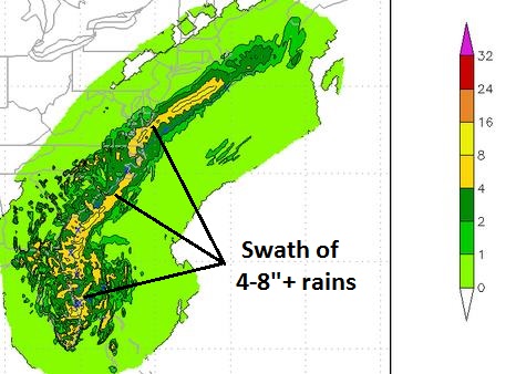
Significant Flood Potential.
Models print out a swath of 4-8"+ rain from near New Orleans, Mobile
and Pensacola well inland to Birmingham, Atlanta and the Carolinas.
Locally, as much as 10-16" of rain may fall if "Erin" takes the track
shown above. Moderate storm surge/wind damage is possible, but as is
always the case with tropical storms and hurricanes, the greatest impact
may come 1-2 days after landfall, in the form of excessive rains and
severe inland flooding.
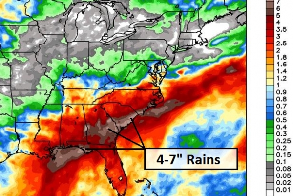
Lingering Flash Flood Potential.
Regardless of where Erin comes ashore, the southeastern USA will see
soaking rains from a stalled frontal boundary, with T-storms
redeveloping along that front, producing some 4-7"+ rains over the next 7
days. Facilities and staff from Mobile and Pensacola to Macon, Augusta,
Columbia, Savannah, Hilton Head, Charleston and Wilmington should be
prepared for a significant risk of urban and river flooding in the days
to come.
Summary: latest
models increase the possibility of a more northerly track across the
Gulf of Mexico. It's still too early to pin down final track, intensity
and implications with any level of confidence, but facilities on or near
the Gulf of Mexico should be in a heightened state of alert, with
possible impacts as early as Saturday. We'll keep you posted.
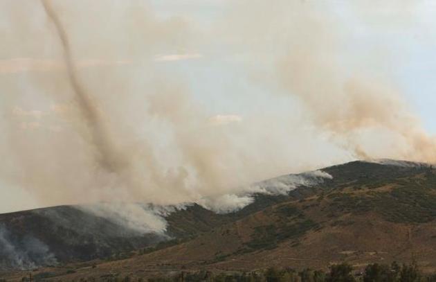
Fire Whirls: A Tornado-like Sign Of An Extreme Wildfire. You thought a tornado was scary? How 'bout a tornado composed of fire and smoke? Here's an excerpt of a remarkable story at
The Salt Lake Tribune: "
Consuming as many as 15 homes, it seemed the rapidly moving Rockport 5 Fire
that forced evacuations in Summit County Tuesday couldn’t get any
worse. Then people started seeing something else: giant funnel clouds of
fire and smoke rising out from the depths of the flames. They’re
called fire whirls, and they’re a sign that the fire is taking control.
The whirls happen when extreme heat meets high winds within a very
healthy wildfire. The two forces combine to form small whirls that
consume smoke and even flames, according to Monica Traphagan of the
National Weather Service in Salt Lake City. "You’re seeing a fire sort
of create its own weather," Traphagan said..."
Photo credit above: Leah Hogsten | The Salt Lake Tribune) "
A
wildfire in Summit County has forced an evacuation of a community and
destroyed up to 15 homes as flames continued spreading Tuesday evening.
The fire is across the road from Lake Rockport Estates, which runs
adjacent to State Road 32 near hamlets of Coalville and Wanship.
Residents there were ordered to evacuate Tuesday, August 13, 2013."
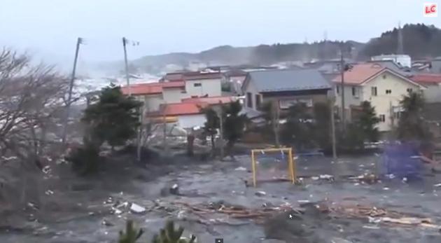
Shocking New Footage Of Japan Tsunami. This video
clip runs 25 minutes, but it's one of the more amazing things I've ever
seen, from a little ripple of water coming up the river to chunks of the
town sweeping past at 30-40 mph minutes later. This captures the
slow-motion horror of a tsunami better than anything I've ever
witnessed. Here's a link to the video and explanation from
wtop.com: "
It
can be hard to fathom the sheer power of mother nature. A horrifying
video has emerged capturing the Japan tsunami from the moment the water
begins to rise. The video, which appeared on RedFlagNews.com, shows
how quickly conditions can change."
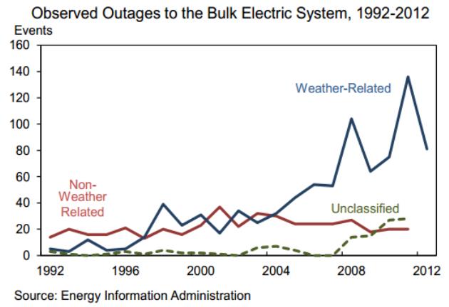
Why Blackouts Are Becoming More Common, In Two Charts.
The Washington Post is running the story - here's the introduction: "
The Department of Energy has a new report (pdf) out
taking a look at the vulnerability of the U.S. power grid to
blackouts. One notable fact: Outages caused by severe weather have
become much more common over the past decade. Power outages of all
sorts are becoming more frequent since 1992, but the real action has
come from weather-related outages. The report notes that “thunderstorms,
hurricanes and blizzards account for 58 percent of outages observed
since 2002 and 87 percent of outages affecting 50,000 or more
customers.” (The rest are caused by things like “operational failures,
equipment malfunctions, circuit overloads, vehicle accidents, fuel
supply deficiencies and load shedding — which occurs when the grid is
intentionally shut down to contain the spread of an ongoing power
outage.”)...
Invasive Ants: "Stowaway" Insects Spreading Around World.
The BBC has the story; here's the introduction: "
A
Spanish team of scientists has found that larger than expected numbers
of the insects are being unwittingly shipped around the world. The
researchers warn that many of these species are establishing colonies
in their new habitats that could pose a threat to the environment,
infrastructure and human health. The research is published in the journal Royal Society Biology Letters.
Lead author Veronica Miravete, from the University of Gerona in Spain,
said: "Due to their small size, most ants are transported
involuntarily in containers and other boxes, together with soil, wood,
ornamental plants and fruits etc, on ships or airplanes..."
Photo credit above: "
Argentine ants have spread across Europe, but there are many more alien species."
Smartphone Batteries Used To Determine Weather Conditions. Here's a novel application - now we're all potential walking, talking (mobile) weather observations. Here's an excerpt from
Gizmag: "
Smartphone
batteries contain tiny temperature sensors, designed to keep the phone
from overheating. While those sensors do measure the heat generated
within the phone, their readings are also affected by the temperature
of the phone’s external environment. With that in mind, British app
developer OpenSignal has created a system that allows multiple users’
phones to provide real-time, location-specific weather reports. The
system is based around the company's existing OpenSignal app, which was
designed to collect data sent voluntarily from users’ Android phones
in order to create maps of Wi-Fi access points and phone coverage..."
Photo credit above: "
A phone running OpenSignal's WeatherSignal app."
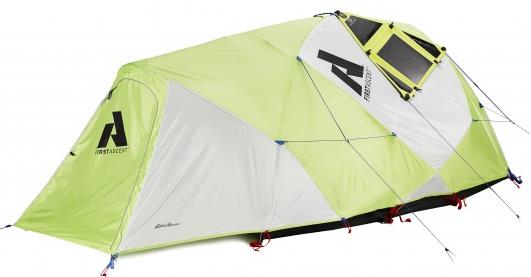
Tents Get Wired For Taking Technology Camping. Kind of defeats the purpose of "camping", but who am I to judge? Gizmag.com has details; here's an excerpt: "There
are those for whom ditching the modern comforts of home and roughing
it is one of the main attractions of camping. For such people, the
traditional tent will likely do. But there is another breed of campers
that can’t stand to be separated from their technology, be it digital
music, videos, tablet computers, drink blenders, etc. For them, there's
a new generation of high-tech tents wired to power all the latest
portable gadgetry..."
TODAY: Mix of clouds, sun, still pleasant. Dew point: 56. S 5-10. High: 79
THURSDAY NIGHT: Mostly clear, not as cool. Low: 60
FRIDAY: Plenty of mild sun. High: 80
SATURDAY: Sunny, warmer. Dew point: 62 Winds: SW 10-15. Wake-up: 63. High: 83
SUNDAY: Hazy blue sky, feels like summer. Wake-up: 65. High: 86
MONDAY: Sunny, almost hot. Dew point: 67. Wake-up: 66. High: 87
TUESDAY: Sticky sun, late T-storms north. Wake-up: 68. High: 85
WEDNESDAY: Few T-storms, humid. DP: 69. Wake-up: 69. High: 86
* a few 90-degree highs are expected by the end of next week, just in time for the Minnesota State Fair.
Climate Stories...
The Complexities Of Climate Change. Here's an excerpt of a story at The Atlantic and
Mother Jones: "
If we're to avoid destructive climate fluctuations, scientists say we need to slow, and eventually halt, the emission of greenhouse gases that
do and will continue to produce global warming. A big chunk of our
emissions come from the consumption of the fossil fuels -- the coal,
oil and gas that remain a crucial part of keeping the modern economy
running. Not an easy task. Let's look at which fuels, and countries,
produce the highest levels of carbon dioxide pollution, and how we can
try to rein these emissions in. In the United States green advocates
are concerned about the climate impacts of all manner of new fossil
fuel developments, but there is one culprit that stands above the rest.
Potential emissions from increased oil production, more shale gas drilling, new pipelines, and exotic fuels pale in comparison to the possible carbon impact from coal reserves..."
Photo credit above:
Claudia Otte/Shutterstock.
The Futility Of "Just The Facts" Climate Science. Here's a clip from a thoughtful story by David Roberts at Grist: "...Anyway,
a democratic public does not want bare facts. It wants meaning. It
wants to know why climate science matters and what can be done about it.
More fundamentally, it’s not just that people want meaning, it’s that
they only absorb facts through meaning. Our identities are how we make
sense of information. This is the whole point of cultural cognition
research: We seek out information that reinforces our identities..."
MSNBC's Chris Hayes On Why So Many Conservatives Deny The Climate Problem: They Hate The Solution.
The "solution" being bigger government. And yet if we don't take some
measures now, put a price on carbon pollution, and incentivize the
marketplace to help with mitigation, we'll be forced to take more
drastic, expensive and intrustive measures as we try to adapt to rising
sea level and more extremes. A bit of a paradox. Here's an excerpt from Think Progress: "...I
have made a different argument: If you hate government intrusion into
people’s lives, you’d better stop catastrophic global warming, because
nothing drives a country more towards activist government than scarcity
and deprivation. Real adaptation requires much bigger and far more intrusive government than mitigation.
Indeed, if the anti-science ideologues continue to stop serious
mitigation, then the government will inevitably get into the business of
telling people where they can and can’t live (can’t let people keep
rebuilding in the ever-spreading flood plains or the ever-enlarging
areas threatened by sea level rise and Dust-Bowlification) and how they
can live (sharp water curtailment in the SW Dust Bowl, for instance)
and possibly what they can eat. Conservative opposition to serious
climate action now will force big government in coming decades to
triage our major coastal cities — Key West and Galveston and probably
New Orleans would be unsavable, but what about Miami and Houston? (See Don’t believe in global warming? That’s not very conservative.)..."
Unicorns Doled Out For Climate Change Deniers. Here's a clip from a story at
CNN: "
As
part of their push to promote President Barack Obama's climate change
agenda, the political group formed from his presidential campaign is
going after Republican lawmakers who have expressed skepticism of
climate change. The group sent a message on Twitter Tuesday with a photo
of a "climate denier award" trophy, topped by a unicorn. The group's
volunteers are delivering the statues to lawmakers Tuesday..."


No comments:
Post a Comment