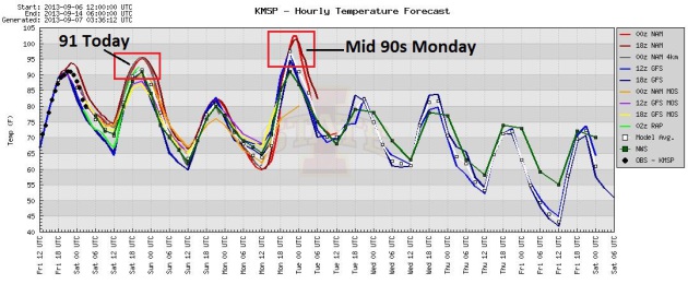
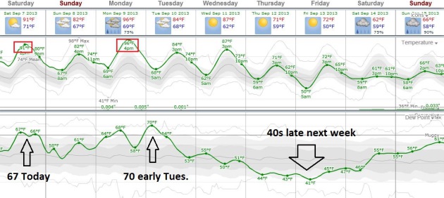
92 F. high in the Twin Cities Friday.
76 F. average high on September 6.
81 F. high on September 6, 2012.
Trace of rain yesterday from early morning showers.
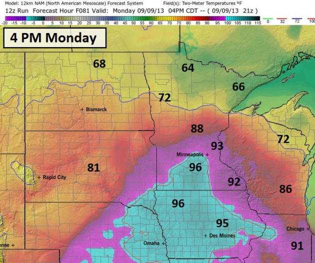
Mid-90s possible Monday (with strong T-storms nearby). Heat Advisory may be issued.
40-degree dew points return the latter half of next week, more September-like temperatures.
Hot Enough
"The only predictable thing about the weather is
that it will remain largely unpredictable." And yet we keep on trying.
Most days we come pretty close, but no matter how good the technology,
there will be days when we shake our heads and shrug in unison.
Weather often comes in cycles; ie. a 4-day and
7-day cycle. Patterns repeat, yes, but the weather machine is inherently
chaotic - it never moves in a straight-line. Temperature contrasts
build and then the jet stream suddenly buckles, throwing the atmosphere
into a new state.
Computer models often pick up on these dramatic
shifts but not always. The larger the north-south temperature extreme
the greater the potential for storm development and rain. The fact that
we'll go from low 90s today to mid/upper 90s Monday (ECMWF model) to 70s
late next week suggests some potential for welcome rains, especially
Monday and Tuesday. But there's precious little water in topsoil to
evaporate into PM storms, and I still don't see the 2-3 day soaking we
need. Most farms & lawns need 3 to 6" rain to pull out of our
drought. That won't happen overnight.
Take a dip in the lake today. Monday may be
beastly-hot but relief is brewing late next week. It'll be nice to be
"average" again.
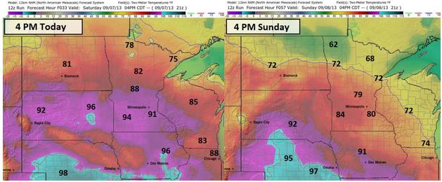
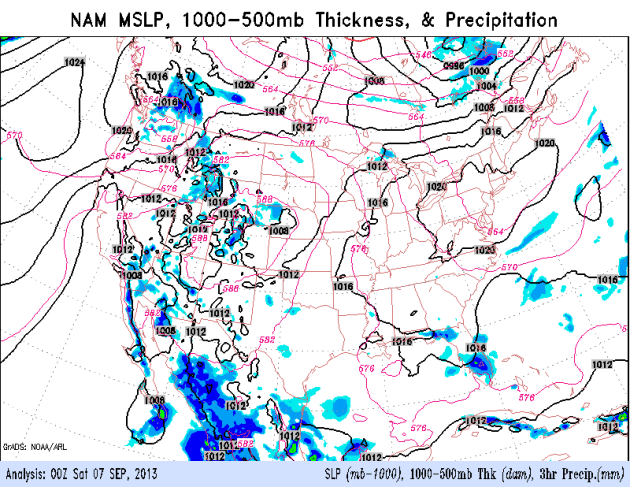
Gradual Weekend Cool-Down. 12km NAM guidance
(courtesy of Ham Weather) shows highs near 90F in the Twin Cities today,
80s for the Alexandria and Brainerd Lakes area, with 70s up north. A
puff of cooler, Canadian air pushes south tomorrow, keeping highs in the
70s over much of Minnesota, even some 60s over far northern counties.
Monday Heat Spike? Maybe it's my imagination, but
we're seeing more of these sudden northward surges of hot weather from
time to time. We had one back in May (72 F high on May 13, then a
whopping 98F high a day later, on May 14), and computer guidance is
hinting at a comfortable Sunday giving way to a very hot Monday, with
the possibility of mid-90s pushing into the Twin Cities metro area. A
large north-south temperature gradient may set the stage for T-storms,
especially northern Minnesota. Right now I don't see any sustained
soakings for the southern half of the state. Map above: Ham Weather.
Last Gasp Of Summer? Don't Count On It. Highs top
90F today, and after cooling off to near 80F Sunday we all get to enjoy
one more heat spike on Monday, when highs may surge into the mid-90s.
The only caveat: if we see T-storms Monday it may not get as hot - but
dew points would be higher, so it's probably a wash. More comfortable,
September-like weather returns after Tuesday of next week.
ECMWF Guidance. Dew points reach the 60s today, and
after a brief dip Sunday return to the 60s to near 70F Monday. Then
comes a significant cool front; dew points drop into the 40s the latter
half of next week. The pattern isn't ripe for widespread/significant
rains looking out about 1 week. Map: weatherspark.
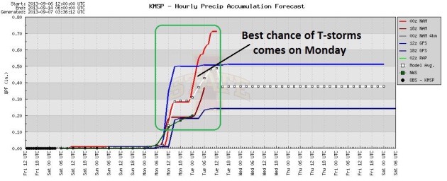
Monday Thunder? T-storms may flare up north of the
Twin Cities Monday, along the leading edge of super-heated air. HIghs
may reach the mid to upper 90s over southern Minnesota, while holding in
the 70s up north - sparking strong storms, especially central and
northern MInnesota.
Easing Into September. The transition from summer
heat to autumn cool should trigger a series of storms and frontal
passages capable of more significant rains in the weeks ahead,
especially the third week of September. Our best (and probably only)
chance of showers and T-storms comes Monday. Meanwhile, cool, sunny
weather lingers over the Northeast; a relatively dry forecast for the
South, monsoon PM T-storms over the Southwest. 84-hour NAM: NOAA.
September Starts Cool And Dry. Here's an excerpt from Dr. Mark Seeley's latest edition of
WeatherTalk: "...
Rainfall
deficits continue to mount in many parts of the state. The U.S.
Drought Monitor now shows that over 53 percent of the state landscape
is in moderate to severe drought. Severe drought is now designated for
parts of Stearns, Sherburne, Benton, Wright, Meeker, and Kandiyohi
Counties in central Minnesota. These counties and others had been
drought-free since mid-May. Volume flow on many Minnesota watersheds is
down as well, in some cases well below average for this time of year.
Unfortunately the outlook favors warm and dry weather through the
third week of September for most of the state...."
Warm Weather Keeps Pools Open Longer, But Hits Farms With Extreme Drought. Here's a clip from a story at
The Star Tribune: ...“
It’s
a bit disconcerting,” said University of Minnesota Extension
climatologist Mark Seeley. “That’s pushing them right back into the
predicament they were in last year." In fact, last year’s drought that
hit Minnesota from midsummer into early winter was among the worst in
state history. In April 2012, nearly 98 percent of the state was in
some kind of drought condition A wet later part of winter and spring
alleviated that, but now drought has returned after a streak of little
rainfall and lingering heat. Since July, Seeley said, rainfall for
central Minnesota is 5 to 7 inches short of average, stressing crops.
“They’ve been sucking the water out of soil,” he said..."
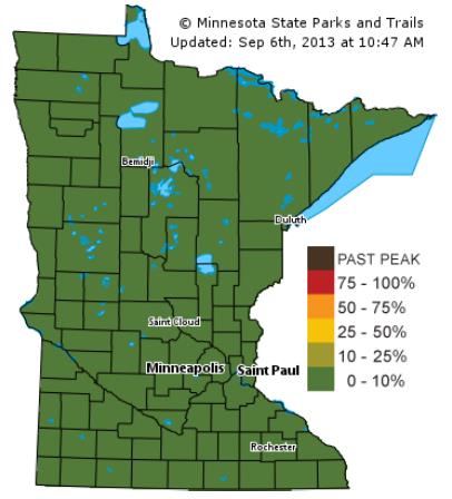
Sign Of The Times. Here's the first fall color update from the
Minnesota DNR. No color yet, in fact dry conditions coupled with unusual late-season warmth may delay peak color by a week or two this year.
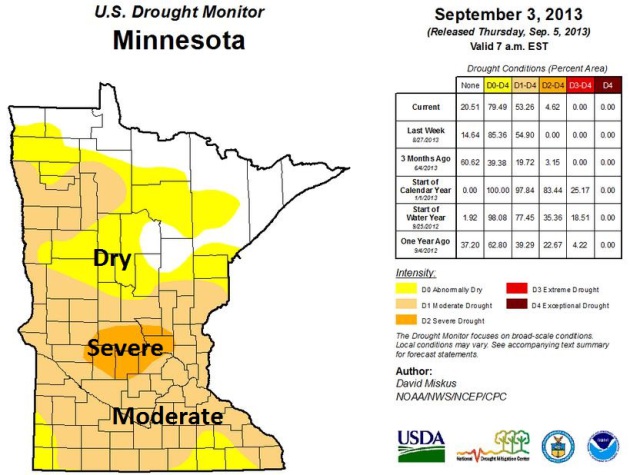
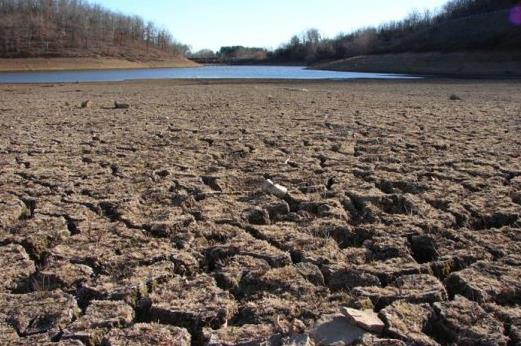
Severe Drought Returns To Central Minnesota. The latest
U.S. Drought Monitor
shows 53% of Minnesota in a moderate drought, 4% in severe drought,
centered on the St. Cloud area, Willmar and Hutchinson. The speed at
which drought is returning and deepening is troubling - only 2 weeks ago
10% of Minnesota was in a moderate drought. Nearly 80% of the state is
described as "abnormally dry".
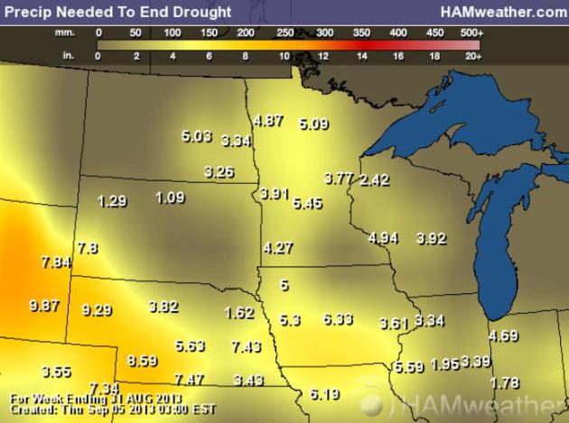
Rainfall Needed To End Drought. Much of Minnesota
needs 3-6" of rain to eliminate the deepening drought. Possible, but not
likely anytime soon. Long-range guidance is hinting at a wetter
pattern next week into the third week of September. Rain may come too
late to help with this year's crop, but a couple of soakings would be
very welcome, recharging soil moisture heading into the winter months.
Map:
Ham Weather.
September 2013 "Hydroclim" Update. Here are highlights of a
statewide summary from Minnesota State Climatologist Greg Spoden:
- August rainfall totals were below historical averages in most
MInnesota counties. In many communities, especially in east central
Minnesota counties, August precipitation totals fell short of long-term
averages by two or more inches.
- Across much of the southern three-quarters of Minnesota,
July-plus-August rainfall totals were 4-6" below normal. Rainfall
deficits, along with very hot late-August temperatures, led to a rapidly
developing drought situation across much of the Midwest.
- The U.S. Drought Monitor places an area of central MInnesota in the
"Severe Drought" category. Large sections of the rest of MInnesota are
rated n the "Moderate Drought" category.
- Ample autumn rains will be required to refill the soil moisture profile and to recharge groundwater and surface water systems.
Flash Drought. Summer came late this year to much of
the northern USA. June was abnormally wet, followed by a heat spike
the first half of July, then came unusually cool weather from late July
into the first half of August, a stubborn northwest wind flow aloft
keeping showers and T-storms away from the Upper Midwest. And then came
the heat; the hottest week of summer arrived during the last week of
August, but T-storms tracked over northern Minnesota - no help to farms,
gardens and lawns over central and southern Minnesota. In this 6-week
animation from the U.S. Drought Monitor you can see the rate at which
drought has returned to the Upper Midwest.
Frosty Lows Friday Morning, courtesy of Mark Hoekzema at Earth Networks:
CNAAN – Canaan, VT – 30 degrees
KSLK – Saranac Lake – Gabriels, NY – 28 degrees
KBML – Berlin, NH – 33 degrees
ROMPA – Rome, PA – 33 degrees
ULYSS – Ulysses, PA – 34 degrees
HNCDL – Hinsdale, NY – 34 degrees
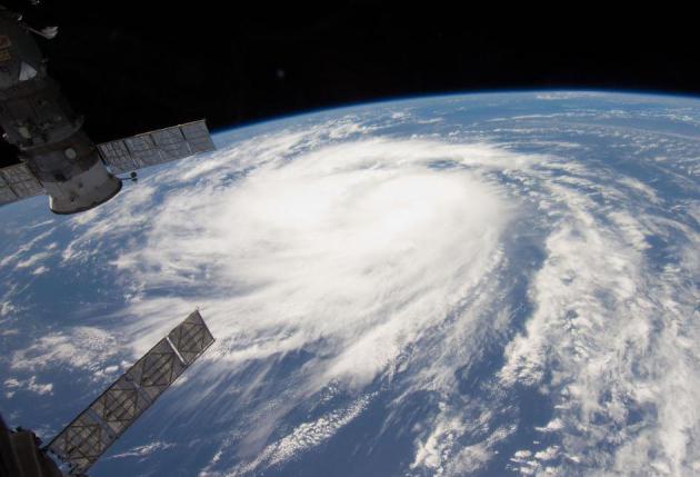
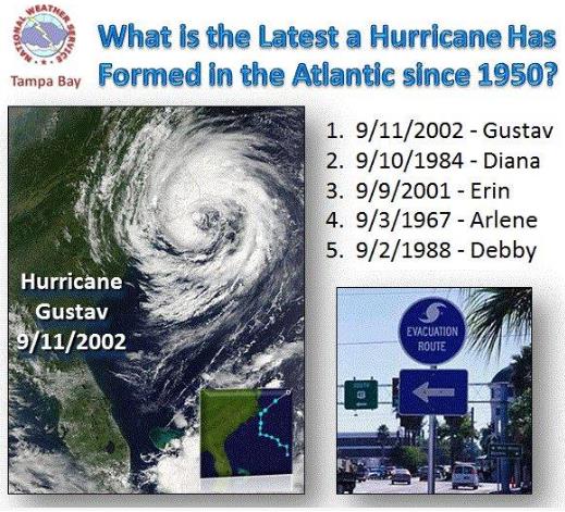
Nearing Record For Latest (First) Hurricane In The Atlantic. Yes, this season may wind up being a dud for hurricanes, but I'm not sure I'd take that bet, not yet. In today's
Climate Matters we look at previous quiet starts to a handful of hurricane seasons that wound up being VERY active: "
Since
record keeping began, the latest the first hurricane has formed in the
Atlantic is September 11th. We're only a few days away from breaking
that record. But just because we haven't seen a hurricane yet,
doesn't mean you should let your guard down. WeatherNation Chief
Meteorologist Paul Douglas shows us how the seasons with late hurricane
starts panned out."
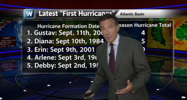
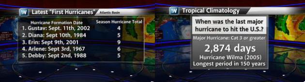 Long Overdue For A (Major) Hurricane
.
It's been 8 years since America has been struck by a Category 3 or
stronger hurricane (Wilma in 2005). If we go 4 more days without a
hurricane we'll set a new record (for latest-first hurricane in the
Atlantic basin). But it's still early to call the hurricane season a
bust. Gustav formed on September 11, 2002, followed by 3 more
hurricanes. Erin didn't form until September 9, 2001. It was one of 9
hurricanes that year, 4 of them major Category 3 storms. Graphics:
WeatherNation TV.
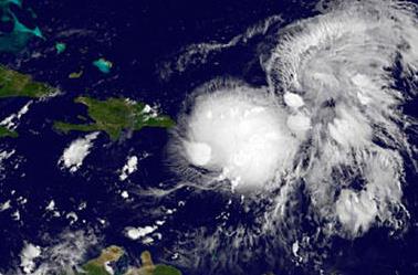
Tropical Storm Gabrielle Fizzles: Why Has Hurricane Season Been So Calm? It's
supernaturally calm in the tropics right now. This is prime-time for
tropical storm and hurricane development, but we're approaching a record
for the latest (first) hurricane on record in the Atlantic basin.
Here's a clip from a story at
The Christian Science Monitor: "...
On
average, however, the season should have seen its first hurricane by
now, and none has emerged. Indeed, the first major hurricane, with
maximum sustained winds of 111 miles an hour or more, typically appears
around Sept. 4, notes Dennis Feltgen, spokesmen for the National
Hurricane Center. If the first hurricane fails to appear until after 8
a.m. Eastern Daylight Time Sept. 15, this will be the most
hurricane-free first half of a season since satellites began tracking
the storms in 1967, he notes in an e-mail. One measure of a season's
oomph is known as the Accumulated Cyclone Energy – a gauge of the
energy tropical cyclones expend one by one and accumulated over a
season. Through Sept. 5, this ACE index has reached only 25 percent of
the 1981-2010 average, according to the NHC data..."
Image credit above: "
This satellite image of shows
tropical storm Gabrielle moving east toward the Dominican Republic
Wednesday. The storm has since been downgraded to a tropical depression." NASA GOES Project/Reuters.
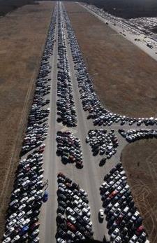
USAA Admits That Some "Totaled" Cars Were Sold. So
that's why I got such a deal on my newest purchase! I was told the car
was "extra-clean", but little did I know... Here's more from
mysanantonio.com: "
USAA
officials now admit that some vehicles it branded as total losses
after being damaged by Hurricane Sandy's floodwaters later were resold
and put back on the road. The San Antonio-based insurer totaled some
4,000 customer vehicles damaged during last year's storm in the
Northeast. USAA earmarked 174 of those vehicles to be sold for parts
only because they had no titles. But USAA later found some buyers who
bought them at auto auctions fraudulently obtained clean titles with
the intention of putting them on the road again...."
Photo credit above: AP. "
This file photo shows thousands
of cars that were damaged in Superstorm Sandy and stored on the runways
at Calverton Executive Airpark in Calverton, N.Y. USAA totaled some
4,000 customer vehicles that had been damaged, but officials for the
San Antonio-based insurer now admit that some vehicles that had been
totaled instead were resold and put back on the road. USAA had
earmarked 174 vehicles to be sold for parts only, but has found that
some were fraudulently given clean titles."
Lackluster Hurricane Season Could Still Rev Up. Yes,
it's amazingly quiet in the tropics, but history teaches us that it
would probably be premature to let our guard down just yet. Here's a
clip from a story at
Live Science: "...
The
lack of hurricanes can be blamed on westerly winds, Weber said. So far
this summer, there have been strong winds blowing from west to east
across the Atlantic, which have systematically destroyed developing
storms and prevented them from strengthening and growing into
well-organized hurricanes,
Weber said. Hurricanes are fueled by the transfer of heat from the
ocean to the upper atmosphere, but they depend on a relatively
symmetrical, rotating system to get going. They form best in calm
conditions, with warm surface temperatures, Weber added. A second,
lesser factor: Dry air and dust have also been blowing westward from
North Africa's Sahel region, hampering development of early season
hurricanes that often form near the Cape Verde Islands in the eastern
Atlantic, Weber said..." (File photo of "Katia" courtesy of NASA).
Latest First Hurricane On Record? Will we go another
4 days without a hurricane in the Atlantic basin? If so we'd set a new
record. The latest (first) Atlantic hurricane on record, to date, is
Gustav, back on September 11, 2002. Graphic courtesy of
Tri-State Weather.
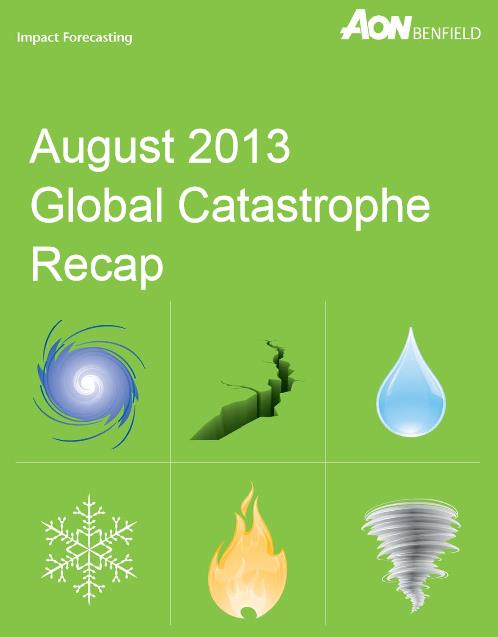
Aon Benfield: August Brings Multiple Billion Dollar Floods Worldwide. Here's an excerpt from a press release at
The Wall Street Journal: "...
The
report reveals that billion-dollar flood losses were recorded in
China, Russia, Philippines, and Pakistan during August, causing an
initial combined estimate of USD10 billion in economic losses.
Persistent rainfall caused flooding across much of China during the
month of August, with Heilongjiang Province sustaining much of the
damage. According to available data from the Ministry of Civil Affairs
(MCA), nationwide totals during August showed that more than 260 people
died, at least 306,000 homes and structures were damaged, and the
aggregate economic loss was at least CNY32 billion (USD5.3 billion).
Across China's northeast border, torrential rains led to the worst
flooding in at least 120 years in Russia's Far East. The Ministry of
Emergency Situations reported that a combined 6,964 homes and 3,762
summer cottages were damaged. More than 627,000 hectares (1.55 million
acres) of agricultural land was also submerged. Total economic losses
were estimated by the government at RUB30 billion (USD1.0 billion)..."
* the August 2013 Global Catastrophe Recap PDF from Aon Benfield is
here.
Why Do Our Best Ideas Come To Us In The Shower? Hmmm. Bathroom shower? Rain shower? Bridal shower? I'm so confused, but
Mental Floss takes us the heart of the matter: "...
Research shows
you’re more likely to have a creative epiphany when you’re doing
something monotonous, like fishing, exercising, or showering. Since
these routines don’t require much thought, you flip to autopilot. This
frees up your unconscious to work on something else. Your mind goes
wandering, leaving your brain to quietly play a no-holds-barred game of
free association. This kind of daydreaming
relaxes the prefrontal cortex—the brain’s command center for
decisions, goals, and behavior. It also switches on the rest of your
brain’s “default mode network” (DMN) clearing the pathways that connect
different regions of your noggin. With your cortex loosened up and
your DMN switched on, you can make new, creative connections that your
conscious mind would have dismissed...
Betty White, "Breaking Bad" Earn Guiness World Records Titles. Here's an excerpt from NBC's
The Today Show: "
Betty
White has had a career for the record books, and finally, it’s getting
officially acknowledged: The 2014 edition of the "Guinness World
Records" book will now list the 91-year-old comedian and actress as the
record-holder for Longest TV Career for an Entertainer
(Female)....White was in good company among other record holders from
the world of pop culture this year; AMC's "Breaking Bad" will be listed
in the new "Guinness" as the Highest-Rated TV Series, thanks to a metascore of 99 out of 100 on MetaCritic.com..."
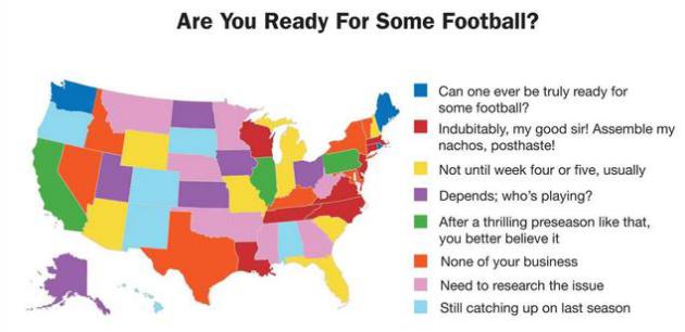
The United States of Football. Map and commentary courtesy of America's Finest News Source:
The Onion.
TODAY: Hot sun - best lake/pool day. Dew point: 65. Northeast 10. High: 91
SATURDAY NIGHT: Partly cloudy, turning a bit cooler. Low: 63
SUNDAY: Blue sky, noticeably cooler and less humid. Dew point: 55. East 10+ High: 80 (metro; 70s central and northern MN).
MONDAY: Very hot. T-storms possible, best chance central/northern MN. Dew point: 66. Wake-up: 66. High: 95
TUESDAY: More clouds, lingering shower, cooler. DP: 57. Wake-up: 68. High: 83
WEDNESDAY: Cool sun, breathing easier. DP: 47. Wake-up: 62. High: near 80
THURSDAY: Blue sky, comfortable. Wake-up: 58. High: 78
FRIDAY: Mild sunshine - feels like September again. Wishing for rain. Wake-up: 55. High: 77
Climate Stories...
Global Warming Has Increased Risk Of Record Heat, Scientists Say. Phys.org
has the story - here's a clip: "...In the north central and
northeastern United States, extreme weather is more than 4 times as
likely to occur than it was in the pre-industrial era, according to a
new study by Noah Diffenbaugh, a Stanford associate professor of
Environmental Earth System Science, and Martin Scherer, a research
assistant in the department....
*
USA Today takes a look at how frequency of extreme heat and coastal flooding have changed in recent decades.
Global Warming Update: Record Heat Is 4 Times More Likely Now Than In Pre-Industrial Times. A slightly different angle on the same story from
Popular Science: "
Here's
your latest global warming update: It's still happening. Intense heat
is now four times more likely to strike in the U.S. than it was in
pre-industrial times, according to a new study
from Stanford University researchers. July 2012 was the hottest month
on record in the lower 48 states, and the summer brought the "most
severe and extensive drought in at least 25 years," according to the USDA.
And it seems summers like last year's are going to become more
commonplace, with 2012-esque temps becoming more likely, specifically in
the north-central and northeastern United States. This study follows
on the heels of a recently leaked draft of an Intergovernmental Panel
of Climate Change report, which noted that scientists believe we are
experiencing more heat waves because of climate change--which yes, we're still sure humans are causing...." (File photo: NOAA).
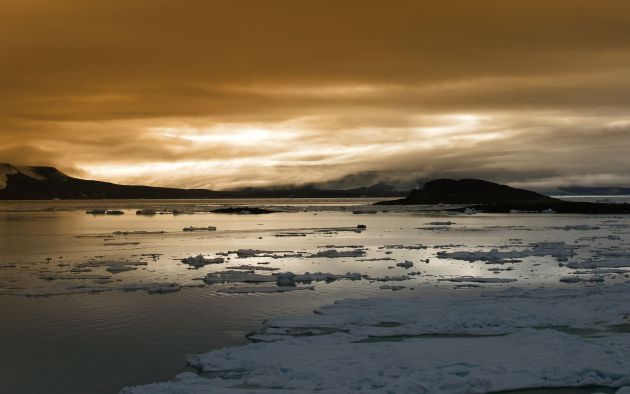
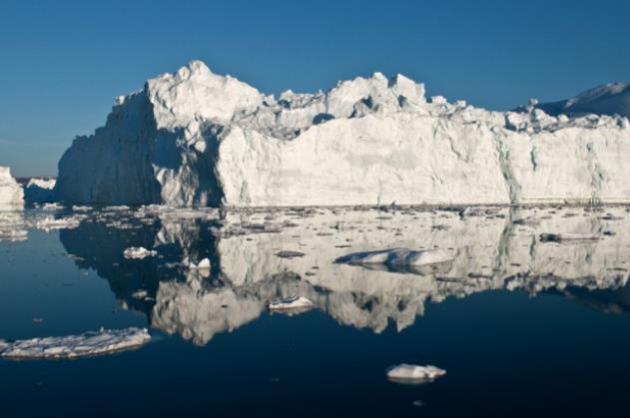
Ice Melting Faster In Greenland, Antarctica In U.N. Leak. The IPCC is about to release another climate update;
Bloomberg Businessweek is running a story with an alleged leak from this upcoming report; here's a clip: "
Ice
in Antarctica and Greenland is disappearing faster and may drive sea
levels higher than predicted this century, according to leaked United
Nations documents. Greenland’s ice added six times more to sea levels
in the decade through 2011 than in the previous 10 years, according to a
draft of the UN’s most comprehensive study on climate change.
Antarctica had a fivefold increase, and the UN is raising its forecast
for how much the two ice sheets will add to Earth’s oceans by 2100. The
changes in the planet’s coldest areas are a “very good indicator” of a
warming planet, according to Walt Meier, a research scientist with the
U.S. National Aeronautics and Space Administration..."
Anglers Feel The Burn Of Global Warming. Michigan's
The Times Herald has a story on the impact to the local fishing industry - here's an excerpt: "...
The
effects of heating the Great Lakes go beyond making some fish winners
and some losers. Lisa Borre, writing for National Geographic, says that
climate change is the main reason the lake’s water levels are so low.
Erosion in the St. Clair River gets some of the blame, but most of the
water that leaves the Great Lakes basin just evaporates. Lake Superior
alone loses 29 billion gallons of water every day from evaporation.
Warming not only means that more evaporates in the summer, but also
means that the evaporation losses don’t stop in the winter because ice
cover doesn’t form..."
In the north-central and northeastern United States, extreme weather
is more than four times as likely to occur than it was in the
pre-industrial era, according to a new study by Noah Diffenbaugh, a
Stanford associate professor of environmental Earth system science, and
Martin Scherer, a research assistant in the department.
Diffenbaugh and Scherer found strong evidence that the high levels of
greenhouse gases now in the atmosphere have increased the likelihood of severe heat such as occurred in the United States in 2012.
Read more at:
http://phys.org/news/2013-09-global-scientists.html#jCpClimate
models are far from perfect, but they've done a pretty good job,
overall, predicting some of the changes we would see, decades in
advance. If anything these models were too conservative with melting ice
over Greenland and the Arctic. Here's an excerpt from
Ars Technica: "
Talk
to someone who rejects the conclusions of climate science and you’ll
likely hear some variation of the following: “That’s all based on
models, and you can make a model say anything you want.” Often, they'll
suggest the models don't even have a solid foundation of data to work
with—garbage in, garbage out, as the old programming adage goes. But how
many of us (anywhere on the opinion spectrum) really know enough about
what goes into a climate model to judge what comes out? Climate models
are used to generate projections showing the consequences of various
courses of action, so they are relevant to discussions about public
policy. Of course, being relevant to public policy also makes a thing
vulnerable to the indiscriminate cannons on the foul battlefield of
politics. Skepticism is certainly not an unreasonable response when
first exposed to the concept of a climate model. But skepticism means
examining the evidence before making up one’s mind. If anyone has
scrutinized the workings of climate models, it’s climate scientists—and
they are confident that, just as in other fields, their models are
useful scientific tools..."
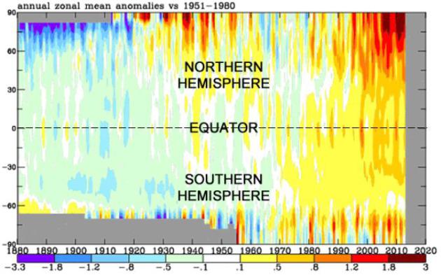
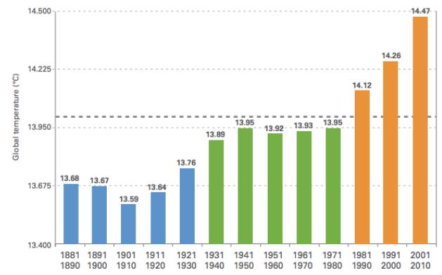
Global Warming In One Unmistakably Compelling Chart. Here's an excerpt from a story by meteorologist Jason Samenow at The Washington Post's
Capital Weather Gang: "
Produced
by NASA, the chart illustrates how temperatures have compared to
“normal” (or the 1951-1980 average) from 1880 to present, from pole to
pole (-90 latitude to 90 latitude). From the 1880 to the 1920s, blue
and green shades dominate the chart, signaling cooler than normal
temperatures in that era. Then, from the 1930s to the 1970s, warmer
yellow, oranges, and reds shades ooze in, balancing the cooler shades.
But since the 1970s, the blue and green shades rapidly erode and
oranges and reds take over, dramatically. The rapid warming at the
northern high latitudes especially jumps out in recent decades,
reflecting “Arctic amplification” or more intense warming in the
Arctic..." (Graphic above: NASA).
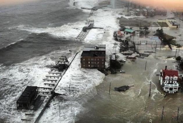
NOAA: Warming-Driven Sea Level Rise To Make Sandy-Type Storm Surges The Norm On East Coast. Here's an excerpt of a story at
Think Progress: "
A
new study by NOAA researchers finds future Hurricane Sandy level
inundation will become commonplace in the future under business-as-usual
sea level rise projections. NOAA’s news release for the report “Explaining Extreme Events of 2012 from a Climate Perspective” summarizes the key finding:
The record-setting impacts of Sandy were largely attributable to
the massive storm surge and resulting inundation from the
onshore-directed storm path coincident with high tide. However, climate-change
related increases in sea level have nearly doubled today’s annual
probability of a Sandy-level flood recurrence as compared to 1950.
Ongoing natural and human-induced forcing of sea level ensures that
Sandy-level inundation events will occur more frequently in the future
from storms with less intensity and lower storm surge than Sandy..."
*
Climate Central has more on the doubling risk of Sandy-scope storm surges.
This September Ask A NASA Climate Scientist. Good for NASA, being more proactive and soliciting questions. Here's more information on the
NASA initiative and a video clip explaining the program: "
The
topic of climate change inspires a lot of debate. At NASA, it has also
inspired a lot of science. NASA scientists examine the Earth's climate
and how it is changing – gaining knowledge through decades of
satellite observations, powerful computer models and expert scientific
analysis. Over the course of this month, these NASA climate experts
will answer selected questions through the agency's social media
channels – primarily on YouTube, Twitter and Google+. But first – we
need your questions. Have a question that's always confounded you about
Earth's climate? Wonder why it matters that the climate is changing
now if it has changed before? Or how scientists know changes seen in
recent decades are the result of human activities, not natural causes?..."
Climate Change Is Cleaving The GOP In Two. Is there a
theoretical revenue-neutral tax on carbon that conservatives might
eventually accept, if not embrace? Here's a clip from a story at The
Tyee and
Salon: "...
A
price on America’s carbon emissions will surely remain theoretical
for some time. No Republican in Congress publicly supports it. Nor does
President Barack Obama. “We would never propose a carbon tax,” the
White House has promised.
Yet the Globe Theatre debate may signal emerging Republican fissures
on global warming. “There is a divide within the party,” one
conservative scholar recently told the National Journal. “The position that climate change is a hoax is untenable...”
Photo credit above:
AP/Ian Joughin.
Study Proves That Politics And Math Are Incompatible. Really? Salon sums up the challenge of separating out ideology from science and math in this piece - here's an excerpt: "It’s hard to look at climate change deniers as being anything other than willfully ignorant. The numbers are right there:
As surely as greenhouse gas emissions are rising, so are global
temperatures. To discount all that is to choose to be stupid. But
according to Yale law professor Dan Kahan, it’s easier than we think
for reasonable people to trick themselves into reaching unreasonable
conclusions. Kahan and his team found that, when it comes to
controversial issues, people’s ability to do math is impacted by their
political beliefs..."
Graphic credit:
"Global temperature by decade." (Credit: World Meteorological Association)
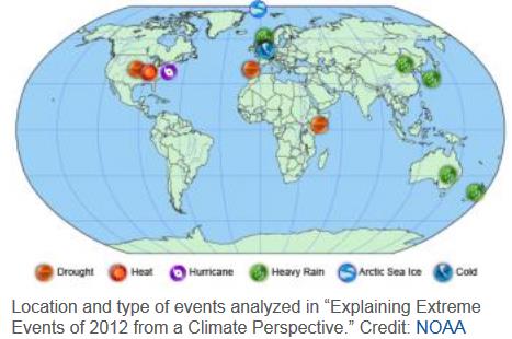
Explaining Extreme Events Of 2012. Here's an excerpt from a summary report by
NOAA NCDC: "...The
report shows that the effects of natural weather and climate
fluctuations played a key role in the intensity and evolution of many of
the 2012 extreme events. However, in several events, the analyses
revealed compelling evidence that human-caused climate change was a
secondary factor contributing to the extreme event. “This report adds to
a growing ability of climate science to untangle the complexities of
understanding natural and human-induced factors contributing to
specific extreme weather and climate events,” said Thomas R. Karl,
LHD, director of NCDC. “Nonetheless, determining the causes of extreme
events remains challenging.” In addition to investigating the causes
of these extreme events, the multiple analyses of four of the
events—the warm temperatures in the United States, the record-low
levels of Arctic sea ice, and the heavy rain in both northern Europe
and eastern Australia—allowed the scientists to compare and contrast
the strengths and weaknesses of their various methods of analysis.
Despite their different strategies, there was considerable agreement
between the assessments of the same events.
* the full report, all 104 pages (PDF) of the report referenced above is
here, courtesy of the AMS, the American Meteorological Society.


I have read your blog about "Paul Douglas Weather Column " really nice & helful. I will get back here again and again
ReplyDeletevulnerability assessment
penetration testing