53 F. high in the Twin Cities Friday.
57 F. average high on October 18.
50 F. high on October 18, 2012.
.02" rain fell at MSP International yesterday.
Frost possible Sunday morning.
Freeze likely by the middle of next week.
Slushy coating central and northern Minnesota Sunday?
Winter Horoscope
"Colder...with some snow."
My official winter outlook is oddly unsatisfying. Then again, when in doubt, obfuscate. Be as vague as possible.
The reality: any weather forecast beyond 10 days should come with a warning label. Like a pack of smokes.
Exhibit A: this year's annual hurricane prediction issued in late spring. Every trusted source was forecasting an above-average year for hurricanes in the Atlantic. Right. Too much Saharan dust, dry air & wind shear created unfavorable conditions for tropical development.
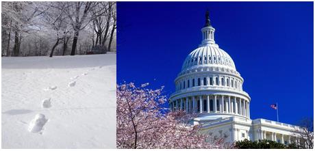
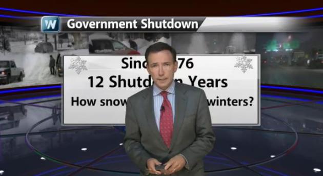
With no strong signal from the Pacific (El Nino or La Nina) I'm relying on new methodology for my winter outlook of "slightly milder & slightly snowier than average". Government shut-downs. Since 1976 the winters following the last 12 shut-downs in DC averaged 4 inches snowier than normal at MSP. As good a leading indicator as any, I'd wager. Details below. In spite of models & hand-waving experts a 4 month weather or financial forecast is pure conjecture. We don't know what we don't know.
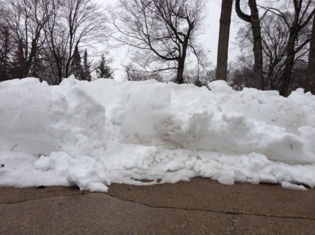
I do know that November is coming early this year. A clipper pushes rain into the metro late Sunday, maybe a slushy 1-2 inches north of MSP. A frost is likely by Sunday; a hard freeze next week.
Heavy jackets prevail for the next week or so - but 50s may return 1 week from tomorrow.
MSP Snowfall During Federal Shut-Down Years:
76-77 43.6"
77-78 50.7"
78-79 68.4"
79-80 53.3"
81-82 95.0" - second snowiest
82-83 74.4"
83-84 98.6" - snowiest
84-85 72.7"
86-87 17.4" - fourth least snowiest
87-88 42.4"
90-91 43.6"
95-96 55.5"
Shutdown Average: 59.6"
1981-2010 Average: 55.5"
*
thanks to Media Logic meteorologist D.J. Kayer for performing these
calculations. If the forecast doesn't work out it's his fault. I wish I
could take credit for this brilliant idea of linking winter snowfall and
government shut-downs. I can't. Kudos to The Capital Weather Gang for making the connection and inspiring D.J. and me to run the numbers for the Twin Cities.
Bigfoot Made Me Do It.
I'm not suggesting there's an ironclad causal correlation between
government shut-downs and snow, but at this point nothing would surprise
me. When it comes to any long-range weather prediction buyer beware.
Everone wants to know what the weather will be like on Christmas Day,
but that doesn't mean the science can support it. Winters are trending
milder, so the (safer) bet would probably be another
slightly-milder-than-average winter for Minnesota. Snow? In recent years
about 1 in 3 winters have brought snowier than average (55") winters.
We had one last winter. Two in a row? Could we be that lucky? Don't hold
your breath. Here's an overview of today's edition of Climate Matters. I had way too much fun with this: "Weather
forecasts beyond ten, twelve, days should have warning labels!
Meteorologist Paul Douglas explains how long range forecasts have little
accuracy. An active hurricane season was predicted this year and we
have seen the quietest season since 1968. Long range winter forecasts
are just as tough."
Like A Long Lost (Crazy) Uncle.
He's baaaack! Old Man Winter will stumble across the state Sunday; a
cold rain for the Twin Cities and southern Minnesota, but there may be
enough cold air aloft for rain changing to sleet and snow over central
and northern counties. A slushy accumulation is possible, maybe an inch
or so on lawns and fields. Map: NOAA and Ham Weather.
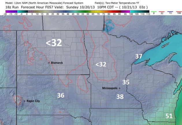
Slush Potential Sunday Night.
Ground temperatures are still quite mild, so even if and when it does
snow up north Sunday it will initially melt on contact. By 10 PM Sunday
the NAM model shows air temperatures below 32F from St. Cloud to
Brainerd, Alexandria and Thief River Falls - so in addition to a coating
of slush some wet roads may become icy.
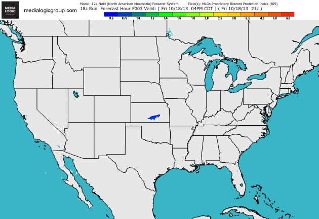
BPI: Blizzard Potential Index.
One of our amazing in-house developers, a meteorologist and weather
model specialist, has created a new tool called the BPI, which analyzes
multiple factors to develop a scale. Anything over 3.0: a significant
risk of blizzard conditions. Sunday's clipper creates an index of .5 to
1, suggesting rain, then a burst of sleet and wet snow.
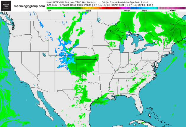
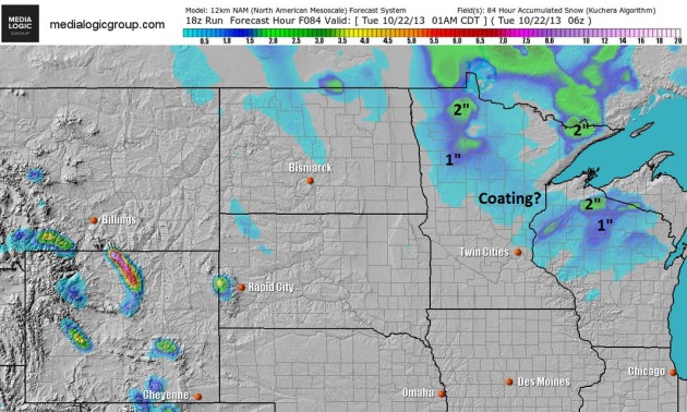
Weekend Clipping.
A few instability showers are likely today, a better chance of steadier
precipitation as an Alberta Clipper dives southeast Sunday triggering a
period of rain, possibly mixing with and changing to sleet (ice
pellets) and wet snow before tapering. 12km NAM data courtesy of NOAA
and Ham Weather.
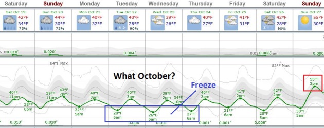
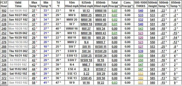
In Search Of October.
This chilly spell lingers into the end of next week, highs some 10-15F
colder than average for mid-October. Frost is possible Sunday morning, a
frost/freeze likely by the middle of next week. But don't despair
(much). ECMWF data above shows highs in the 50s a week from tomorrow.
Graph: Weatherspark.
Wet Start To October. Here's an excerpt from Dr. Mark Seeley's weekly WeatherTalk Newsletter that caught my eye: "After
a relative dry start to the month, this October is turning into a
wetter than normal month with over two weeks yet to go. Significant
rainfall totals this week in combination with those that fell earlier in
the month have added up to over a month's worth at several locations.
Normal October precipitation values (1981-2010) generally range from 2.0
to 2.5 inches, but many observers are already reporting over 4 inches,
including Moorhead, Fergus Falls, Pelican Rapids, Melrose, Willmar,
Cloquet, Isle, Moose Lake, Zumbrota, and Austin. Some observers have
already had over twice normal monthly precipitation including Browns
Valley (5.23"), Onamia (5.46"), Caledonia (5.55"), Chatfield (6.10"),
Preston (6.73"), and Grand Meadow (7.08"). 2013 is the 4th wettest
October in history (back to 1887) at Grand Meadow already..."
Ask Paul. Weather-related Q&A:
When it comes to weather-related matters I trust your assessments more than anyone else in our neck of the woods (Mpls./St. Paul). I read your response to Joe from Eau Claire, and pardon if I'm a bit redundant, has cold weather moved in to stay for a few months? High's around 50 next weekend and possibly Halloween? Seems we always get a little reprieve from the first frosts. I know we ask a lot of crystal ball gazers such as yourself, tell me honestly though, how do the next few weeks look?
Thanks a lot,
Brad Stauffer from Minneapolis
Brad
- thanks for the kind words (are we related?) I would wager a very
small sum that we will see more breaks from the chill in the weeks
ahead. I do NOT think we're going to be consistently colder than average
into November. Unusually cold spells are often followed by warm-ups of
almost equal magnitude. I'm leaning toward the ECMWF (vs. the GFS above)
that indicates 50s a week from tomorrow, then colder as we approach
Halloween. GFS data shows highs near 60F the following Sunday, November
3. Expect a slow stair-step into winter, with occasional mild spikes.
Nature rarely moves in a straight line.
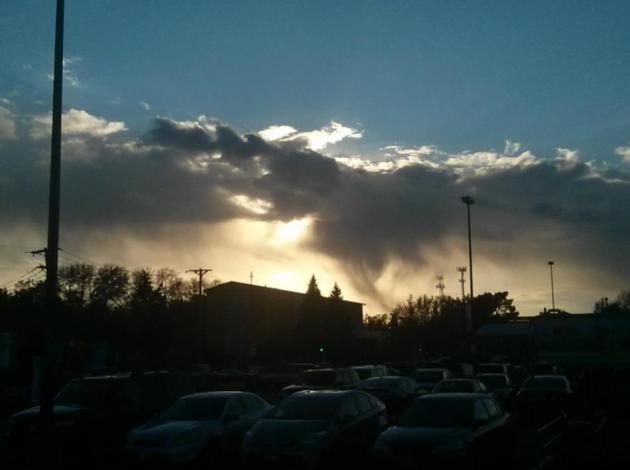
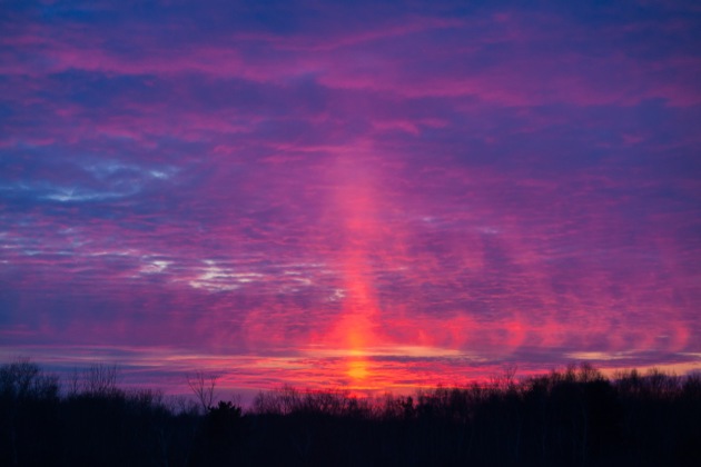
Paul,
I've never seen a cloud formation like this. What would cause this? I took the photo in South Mpls on Friday evening facing west.
Josh Downham, Minneapolis
Josh - thanks for a great example of "virga", illuminated by a low sun angle shining underneath the cloud base. Much of the rain is evaporating into drier air near the surface, leaving behind a cone-shaped swirl of rain drops, swept southeast by gusty winds near the ground. Virga is often mistaken for tornadoes from a distance, but the lack of rotation (and lightning nearby) is a tip-off that it's benign. That, and a dew point of 30 - that's a pretty good tip-off that tornadoes are the least of your concerns.
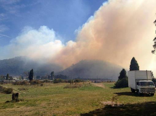
Raging Brushfires Are Leaving Sydney Shrouded In Smoke. Quartz has more information on the fires burning out of control around Sydney, Australia - here's an excerpt: "Billows of smoke have engulfed almost the entirety of Sydney’s skyline, while hundreds of firefighters are trying to tame to the worst bushfires suffered by the city in over a decade. Compounding
the already severe problem are winds of up to 50 miles per hour (80 km
per hour) and temperatures of nearly 90 °F (32 °C). More than 600
hectares (1480 acres) have already been scorched, and local authorities
fear home losses could creep into the thousands. “If we come out of this
day without losing hundreds of homes we’ll be very lucky,” Rural Fire
Service deputy commissioner Rob Rogers told ABC Radio. Of the over 60 fires still burning, 20 still remain uncontained. Sydney, at present, is shrouded in smoke and ashes.."
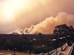
Photo credit above: HOPD. "In this photo provided by the New South Wales Rural Fire Service, smoke rises from a fire near Springwood, west of Sydney, Thursday, Oct. 17, 2013. Nearly a hundred wildfires are burning across Australia's New South Wales state, more than a dozen of which are out of control, as unseasonably hot temperatures and strong winds fanned flames across the parched landscape." (AP Photo/New South Wales Rural Fire Service).
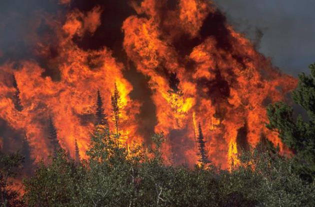
- The largest fire in Arizona’s history (2011’s Wallow Fire)
- Both the largest and most destructive fires in New Mexico’s history (2012’s Whitewater-Baldy Complex and Little Bear Fires, respectively)
- The most destructive fire in Texas’ history (2011’s Bastrop County Complex Fire)
- The first and second most destructive fires in Colorado’s history (2013’s Black Forest and 2012’s Waldo Canyon Fires, respectively)
- The third largest fire in California’s history (2013’s Rim Fire)


An Army Of Robot Baristas Could Mean The End Of Starbucks As We Know It.
Say it isn't so. Robots may be able to make a perfect latte, but what
about idle banter and meaningless chit-chat at the cash register, huh?
Here's a clip from Quartz: "Starbucks’
95,000 baristas have a competitor. It doesn’t need sleep. It’s precise
in a way that a human could never be. It requires no training. It can’t
quit. It has memorized every one of its customers’ orders. There’s never
a line for its perfectly turned-out drinks. It doesn’t require health insurance.
Don’t think of it as the enemy of baristas, insists Kevin Nater, CEO of
the company that has produced this technological marvel. Think of it as
an instrument people can use to create their ideal coffee experience.
Think of it as a cure for “out-of-home coffee drinkers”—Nater’s
phrase—sick of an “inconsistent experience...”
Photo credit above: "Finally, a barista you don't have to lie to about how your day is going." Briggo.

"Aeromobil": A Flying Car Reimagined.
I wonder if any of the current crop of flying car initiatives will get
off the ground - I hope so. This is one good-looking car/plane; details
from Gizmag: "There
is a saying in flying: “If it looks good, it will fly well.” Stefan
Klein, a designer from the Slovak Republic, has announced the first
flight of his Aeromobil Version 2.5, a flying car prototype he has been
developing over the last 20 years. This vehicle is a strikingly
beautiful design with folding wings and a propeller in the tail. But
will its flight capabilities match its looks?..."
TODAY: Mostly cloudy, few showers. Winds: W 10-15. High: 45
SATURDAY NIGHT: Patchy clouds, risk of a frost in the suburbs. Low: 33
SUNDAY: Mostly cloudy and windy with showers (mixed with wet snow central and northern MN where a light slushy coating is possible). High: 45
SUNDAY NIGHT: Sprinkles taper, possible as a few flurries. Low: 31
MONDAY: Feels like late November. Some sun. High: 41
TUESDAY: Early freeze. Light PM mix of rain and snow, best chance south/west of MSP. Wake-up: 27. High: 42
WEDNESDAY: Intervals of sun. What October? Wake-up: 27. High: near 40
THURSDAY: Partly sunny, still brisk. Wake-up: 28. High: 42
FRIDAY: Mix of clouds and sun. Wake-up: 31. High: 43
* ECMWF and GFS guidance is hinting at 50s Sunday afternoon, the 27th.
** sun pillar image above courtesy of Steve Burns.
Climate Stories...

Water Vapor In The Upper Atmosphere Amplifies Global Warming, Says New Study. NOAA has the story - here's the introduction: "A new study
shows that water vapor high in the sky and the temperature at the
Earth’s surface are linked in a “feedback loop” that further warms our
climate. Published today, this study gives the first estimate of the
size of the feedback’s effect, which may help researchers improve
modeling to better understand climate change. “Water vapor in the
stratosphere increases in tandem with increases in the Earth’s surface
temperature,” said coauthor Sean Davis, a scientist at the Cooperative
Institute for Research in Environmental Sciences working at the NOAA
Earth System Research Laboratory in Boulder, Colo. “Because water vapor
is a greenhouse gas, this generates additional warming. We show that this feedback loop could be about 10% of the climate warming from all greenhouse gases...”
Iowa Scientists: Climate Change Affecting Farming. Here's an excerpt of a story at seattlepi.com: "Several
Iowa scientist are releasing a report on how they believe climate
change is affecting farmers. A report "Iowa Climate Statement 2012:
Climate Change Threatens Iowa Farms" will be released Friday at Drake University. Researchers and professors from Iowa State University, the University of Iowa, the University of Northern Iowa, Drake, and Mount Mercy University
will release the report. The report looks at the extreme weather this
year marked by the wettest spring on record followed by the
second-driest July through September ever..."

Michael Mann, Off Battlefield, Discusses "Climate Wars". Andrew Freedman has the story for Climate Central; here's the intro: "Michael
E. Mann sounds remarkably upeat these days considering that he has been
under assault for more than a decade by investigations, criticisms, and
even death threats for his work as a climate scientist. Perhaps he’s
been buoyed by the fact that the Virginia Supreme Court recently halted
State Attorney General and Republican gubernatorial candidate Ken
Cuccinelli’s investigation into Mann’s use of state funds for climate
research. That case, which was widely viewed as politically motivated, galvanized the climate science community because of the threat it posed to academic freedom and scientific inquiry..."

Climate Change Panel Features Varying Perspectives With Common Goal. Wisconsin's Badger Herald has the story - here's a clip: "...The
benefits of cleaner air, because of public health costs, are you gain
$49 on average from every ton of carbon dioxide you remove … the cost of
cleaner energy is $30 on average per ton of carbon dioxide removed,”
Patz said, drawing on evidence from a study conducted by fellow panelist
Gregory Nemet, associate professor in Public Affairs and Environmental
Studies. The gains of moving to cleaner energy clearly outweigh the
costs, Patz said. Nemet said there is an exponential increase in
temperature projected for the next 100 years. “We need to decarbonize at
a rate of 5 percent or 6 percent per year,” Nemet said. “You can’t deny
that people are burning coal. It’s cheap, domestic and extremely carbon
intensive...”
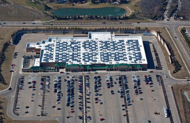
Walmart Leads Companies Investing In Solar.
Are they doing it to be altruistic, because it's the right thing to do,
for customers, shareholders and the environment? Possibly, but I
suspect it's because over the long term they can operate with greater
efficiency, save money, and pass those savings along, making them even
more competitive. Smart. Here's a clip from Daily Finance: "Solar
continues to "go through the roof" in the U.S. commercial sector. The
Top 25 corporate solar users nationwide have deployed 445 MW of capacity
thus far this year, up 48% over the same period in 2012, according to a
report released this week. And leading the pack for the second
consecutive year is America's largest retailer, Wal-Mart
, with 89 megawatts of photovoltaic capacity installed at 215 company
facilities in 11 states. Those are the findings of "Solar Means
Business 2013" study, conducted by the U.S. Solar Energy Industries
Association, a trade group based in Washington, DC, in cooperation with
the Vote Solar Initiative, a non-profit organization based in San
Francisco..."
Photo credit above: solarbuildermag.com.
No comments:
Post a Comment