18 F. high in the Twin Cities Sunday (12:41 PM).
24 F. average high on January 26.
23 F. high on January 26, 2013.
1.1" snow fell yesterday at KMSP.
13" snow on the ground at Twin Cities International Airport.
46 mph: peak wind gusts yesterday (mid-afternoon hours).
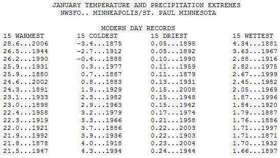
9.4 F
average January temperature so far in the Twin Cities. If the average
January temperature reaches 4.3F or colder this January would fall into
the Top 15 Coldest Januaries at MSP. Details below:
Well Preserved
Almost
anywhere else in America, with the possible exception of Fairbanks, the
National Guard would be called out by now. FEMA would be advising us to
shelter in place. Local TV stations would be droning on with continuous
coverage.
No matter how many schools close today life goes on.
Most of us will trudge to work or the local store. You may even see a
few crazies jogging and cross country skiing, in spite of a -45F wind
chill early today.
Canada launches another full-frontal assault,
another artillery blast of numb to rival January 6-7. For all intents
and purposes it will be just as cold. At the rate we're going kids may
still be in school on the 4th of July.
I know, not funny.
After
bottoming out near -22F Tuesday morning the mercury rebounds into the
20s Wednesday; the first week of February still colder than average, but
not as polar.
Why so much wind this winter? The sharper the
temperature contrasts the stronger winds have to blow to keep the
atmosphere in a state of equilibrium, however uncomfortable.
If
you're curious odds favor clearing skies and 30s for Super Bowl Sunday.
Meanwhile a couple inches of slushy snow may coat the Florida Panhandle
by Wednesday.
Yes, we feel their pain.
Still Waiting For Winter In Alaska.
60s with no snow in Alaska's Kenai Peninsula. Freakishly springlike,
while much of the north central USA shiver into Tuesday. Details below.
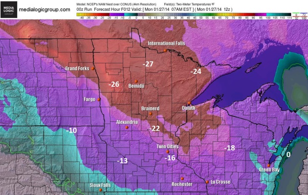
7 AM Today.
We should be waking up to temperatures in the -14 to -18F range across
most of the metro, some -20F readings far northern suburbs. A strong,
lingering wind will make it feel like -40F at times, colder up north.
Map: NOAA and Ham Weather.
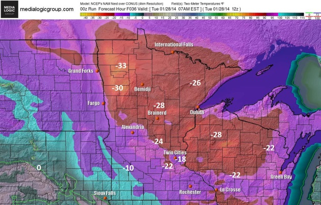
Scraping Bottom?
It appears the core of the coldest surface temperatures passes over
Minnesota late Monday night and early Tuesday, with wake-up readings
ranging from -18 to -24F in the metro (mildest lows in the immediate
downtowns, where the urban heat island will keep readings milder). Winds
ease a bit, with a chill factor of -30 to -40F. No weather bargain by a
longshot, but it'll keep us honest.
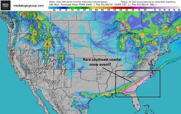
Ski Savannah?
The leading edge of one of the two coldest airmasses of winter may spin
up a storm capable of rain changing to snow from near Pensacola to
Augusta, Savannah, Charleston and Wilmington, even a few inches of slush
- enough to snow and shovel. Do people living there even own shovels.
NAM guidance: NOAA and Ham Weather.
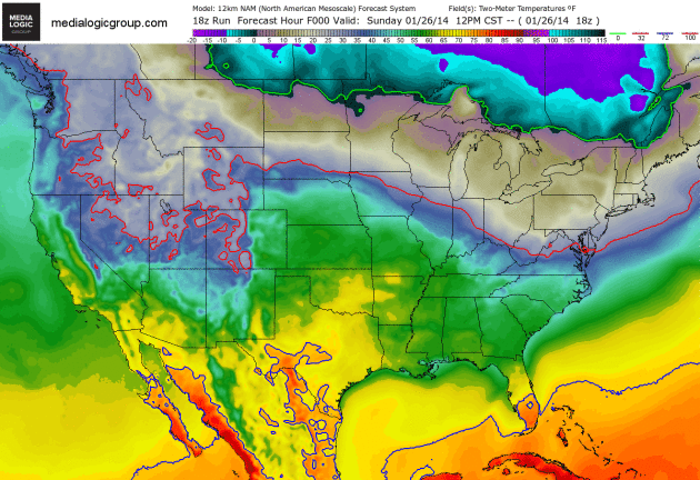
A Cold Kink In The Jet Stream.
Instead of seeing a "progressive" weather pattern, where the jet stream
varies over time, pulling in a mix of mild and cold, weather systems
have stalled, the steering winds aloft temporarily locked in a pattern
favoring record warmth and drought from the western USA to Alaska, and
polar air vectoring due south, invading much of the central and eastern
USA. 2-meter NAM temperatures out 84 hours from NOAA and Ham Weather.
A Faint White Light At The End Of A Very Cold Tunnel?
Naw - I'm just messing with you! At some point Canada will run out of
cold air. They'll make more, of course, because that's what they do.
It's barbaric - weather terrorism if you ask me. We are all under
attack. Write your Congressperson. Temperatures hold below 0F until
Wednesday morning; 20s will heal your brittle soul by Wednesday, again
next weekend. Not great, but better. ECMWF data: Weatherspark.
Alerts Broadcaster Special Briefing: Issued Sunday afternoon, January 26, 2014.
* I still don't see a major storm, certainly no blizzard for Super Bowl Sunday on February 2, 2014.
*
Latest models hint at a possible rain/snow shower Sunday morning, with
clouds lingering most of the day - but I expect a drying trend during
the PM hours Sunday at MetLife Stadium, temperatures falling through the
30s with west winds at 10-15 mph.
* New York City will get a taste of the polar cold, but temperatures moderate somewhat by next weekend, closer to average.
*
Right now I don't expect any major transportation challenges the Friday
before the big game, but a light rain/snow mix may create some (minor)
slushy issues Saturday. What has changed since yesterday? Models bring a
rain/snow mix into metro New York during the day Monday. Getting out
late Sunday or first thing Monday might be a prudent plan, reducing the
risk of delays, until the pattern crystallizes we want to err on the
side of safety and caution.
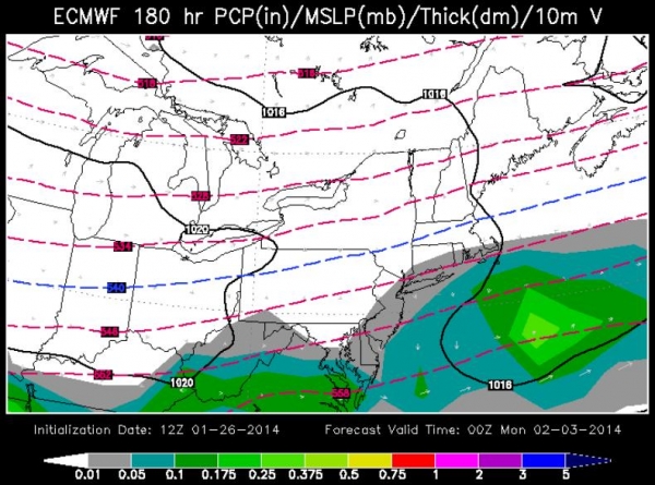
Sunday Evening Weather Map.
This is ECMWF (European) model guidance, showing a cold rain offshore
by Sunday evening, clouds lingering over East Rutherford, New Jersey,
with a drying/cooling west to northwest breeze. It's a little close for
comfort, but assuming this guidance verifies I wouldn't see any steady
rain or snow for the game itself. Map above: WSI.
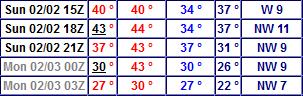
GFS Solution.
NOAA's GFS model suggests temperatures in the upper 30s midday Sunday,
falling to near 30F by 8 PM Sunday evening, with a west breeze (and no
steady/heavy precipitation).
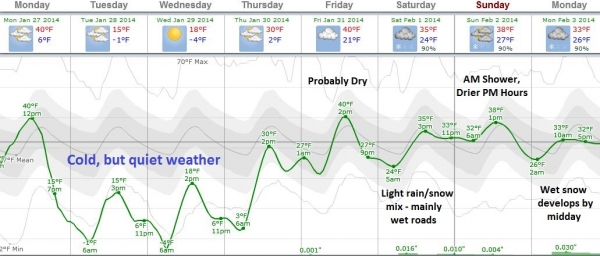
Super Bowl Planner.
Highs hold in the teens Tuesday and Wednesday, rebounding by the end of
the week. Odds favor generally dry weather Friday, with a light
rain/snow mix spreading into north Jersey Saturday. With surface
temperatures in the low to mid 30s I expect most roads (and runways) to
be wet, possibly slushy in spots, but no widespread travel headaches
that I can see. An early shower Sunday should give way to drier
conditions by afternoon and evening, although clouds will linger. High
humidity levels will create a wind chill in the low to mid 20s, a bit
raw at MetLife Stadium, but tolerable. The big unknown is whether the
precipitation forecast for Monday, February 3, is real, or a computer
artifact. I could see a better chance of traffic delays with wet snow
the Monday after the Super Bowl. Graph: Weatherspark.
Summary:
Although not quite as mild as yesterday's solution, I have high
confidence that temperatures will be in the 30s for the Super Bowl, with
moderate confidence of no steady/heavy rain or snow. A snow shower
can't be ruled out during the morning and midday hours next Sunday, but
skies will probably dry out during the afternoon and evening hours.
Getting in Friday shouldn't be a problem, some delays possible Saturday
with a light mix of rain/snow pushing into metro New York, another
chance of (mostly) snow the Monday after the game.
This is still a
7-Day forecast, so overall confidence levels remain low. I want to be
transparent about setting weather expectations, knowing the forecast
will invariably change as new data comes in. But right now I do not see
any blizzards or major storms on February 2 in the New York City area
that would have a high impact on travel or events. Stay tuned...
Paul Douglas - Senior Meteorologist - Alerts Broadcaster
New York Area Weather Has A History With The Super Bowl. Check out weather for previous games in the NYC area in early February. From the sublime to the horrific, as reported by
The New York Times; here's an excerpt: "
In
the countdowns to each of the previous 47 Super Bowls, the primary
question was, quite simply, Which team will win? But as Denver and
Seattle await XLVIII next Sunday at MetLife Stadium in East Rutherford,
N.J., questions about the weather for the first outdoor cold-climate Super Bowl
have upstaged even the point spread. How cold will it be? How windy? If
it snows or rains, how much and when? Before the game? During the
game?...."
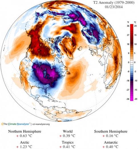
The Alaskan Winter That Never Was? Greg Laden takes a look at historic warmth (and lack of snow) across portions of Alaska at
scienceblogs.com: "...
I had heard it was warm in Alaska, but holy moly, I didn’t know it was THIS warm. Above is an anomaly map showing the Drunken Arctic Air
in central and eastern Canada and the US in contrast with the very
(relatively) warm air over western Canada and Alaska. Remember, these
are anomalies, not absolute temperatures. But still, it is warm enough
in at least parts of Alaska that lakes that are normally well frozen by
now are not frozen at all and may not even freeze this winter. Here are
photographs taken by A.M.Mueller on January 25th 2014 in Skilak Lake,
Kenai Peninsula, Alaska, and passed on for posting, with some
commentary...."
California's Drought, Time Three. Here's an excerpt of an Op-Ed at
The Los Angeles Times: "...
Because
these three droughts are interconnected, we rarely suffer from one
without dealing with the others, and this year's situation is no
different. The vast majority of Californians rely on water that falls in
other parts of the state, or even outside the state, and although the
multiple sources make water more secure for all of us, shortages usually
come all at once. Southern California must prepare for the future by
recapturing more of the rainwater that in wetter years still runs,
unused, to the sea. It must do even more than is already being done to
clean and reuse urban water..."
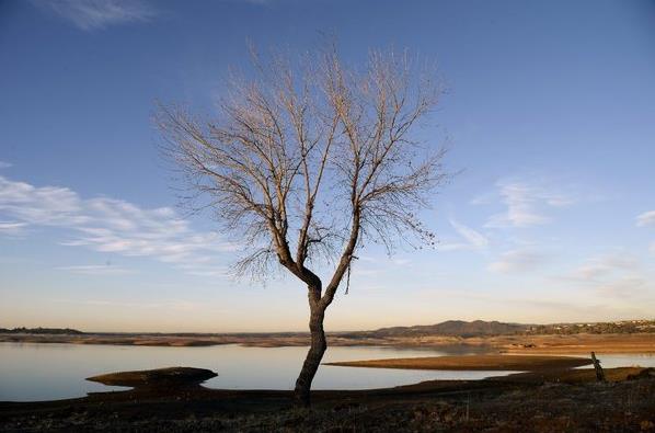
Photo credit above: "
Seen
above on Tuesday, a tree that is usually at the banks of Folsom Lake
outside Sacramento is now several hundred feet away from the water. In
his drought emergency declaration, Gov. Jerry Brown asked Californians
to cut their water usage by 20%."
(John G. Mabanglo / EPA).
Better Setting Tornadic Expectations: From "Slight" to "Enhanced" Risk.
The take-away; a "slight risk" day, as defined by NOAA SPC, can still
generate significant, life-threatening tornadoes. Here's a clip from a
story at
The Christian Science Monitor: "...
For
several years, the National Weather Service has been working with
social scientists to find better ways of communicating the contents of
its forecasts in ways meaningful to emergency managers, radio and TV
weathercasters, and the general public, not just experienced
forecasters, notes John Ferree, the SPC's severe-storms services leader.
But the "slight" category for severe storms and for tornadoes actually
spans a threefold increase in risk, from a 5 percent chance of severe
weather to a 15 percent chance, he notes. At 15 percent, the risk for
severe weather is considered moderate..."
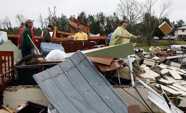
Photo credit above: "
Shuqualak,
Miss. residents clean up debris after a tornado plowed through rural
sections of eastern Mississippi in April 2013. The Storm Prediction
Center plans to broaden its warning system for severe weather after
finding the days labeled as “Slight Risk” turned out to have storms that
could be deadly."
Rogelio V. Solis/AP.
Researchers Digging Into Data On Quiet Hurricane Season.
Last year's hurricane prediction was a bust - it was the quietest year
in the Atlantic since 1982. What happened, and can a long-range
hurricane forecast even be trusted? Here's a clip from a story at
The Coloradoan: "...
Gray
and Klotzbach believe a significant cooling of waters in the eastern
Atlantic associated with a weakening of the thermohaline circulation --
or the Atlantic Multidecadal Oscillation -- in the spring months was the
primary reason for the inactivity. But there are significant
disagreements between historical datasets about the conditions of the
atmosphere during the June-November hurricane season..."
Graphic above:
RMS.com.
What Drives Success?
Everyone wants shortcuts and easy-to-digest TV-soundbite answers; it
turns out the answer is a little more complex. Here's an excerpt of a
fascinating read at
The New York Times: "...
It
turns out that for all their diversity, the strikingly successful
groups in America today share three traits that, together, propel
success. The first is a superiority complex — a deep-seated belief in
their exceptionality. The second appears to be the opposite —
insecurity, a feeling that you or what you’ve done is not good enough.
The third is impulse control. Any individual, from any background, can
have what we call this Triple Package of traits. But research shows that
some groups are instilling them more frequently than others, and that
they are enjoying greater success..." (Photo credit:
Ji Lee).
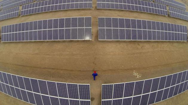
China Installed More Solar Panels In 2013 Than Any Other Country Ever Has.
Quartz has the story - here's the intro: "
China is now home to more solar panels than any other country, after installing 12 gigawatts of solar panels in
2013, according to Bloomberg New Energy Finance. That’s equal to the
total amount of panels in the entire United States, and more than any
country has ever added in a single year. Greenpeace estimates the figure
is a bit lower, but still record-breaking, at between 9.5 and 10.7 gigawatts..."
Photo credit above: "Harnessing the power of government subsidies." Reuters/Carlos Barria

Get Ready For A Shock: The World's Fastest Supercar Might Soon Be Electric. For a cool million and change this can be yours!
CNN has the details on the Concept_One; here's a clip: "
At full speed, the Rimac Concept_One
is little more than a cherry red blur, flashing from one corner of the
horizon to the other in the blink of an eye. If its projected
performance figures prove to be true, this radical electric concept car
-- the brainchild of an award-winning young Croatian designer -- could
accelerate faster than all but two of the fastest supercars
on earth. The Rimac Concept_One's figures are impressive. Not just for
an electric car, but for traditional petrol-engine cars as well..."
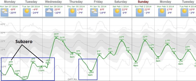
TODAY: Windchill Warning. Partly sunny and sub-arctic. Feels like -45 early. High: -8
MONDAY NIGHT: Clear - one of the two coldest nights of winter. Low: -22
TUESDAY: Still polar with blue sky, slightly less wind. WC: -40. High: -3
WEDNESDAY: Fading sun, closer to average. Wake-up: -9. High: 25
THURSDAY" Snow near Iowa border. Colder. Wake-up: 13. High: 14
FRIDAY: Sunny, still nippy. Wake-up: -8. High: 9
SATURDAY: Clouds increase, not as harsh. Wake-up: 4. High: 22
SUNDAY: Intervals of sun. No sign of spring. Wake-up: 2. High: 21
Climate Stories...
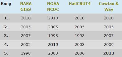
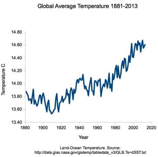
5 Warmest Years, Worldwide. 4 different methadologies for making the global calculations - two of those have 2013 as a Top 5 Warmest Year. Credit:
Stefan Rahmstorf.
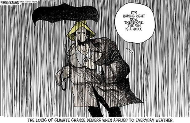
No, Global Warming Isn't Suddenly A Myth Because It's Really Cold Out. Unless you can look out your window and see the entire planet, it's just "weather", not climate. Here's an excerpt from
U.S. News and World Report: "...
There
appears to be a psychological basis for the way our collective concern
about global warming tends to fall with the autumn leaves and rise
whenever the mercury does. A 2011 study
by researchers at Columbia University found that study participants who
described the day they were surveyed as warmer than usual expressed
more concern about global warming, and were willing to donate more money
to a relevant charity. The opposite effects were observed in
participants who described the day as colder than usual..."
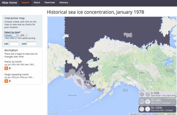
New Sea-Ice Map Offers A Long-Term Look At Climate Change.
Alaska Dispatch has a very interesting story - here's the introduction: "
Mining
more than a century of sea ice observations, including from 19th
century Yankee whalers and 20th century Arctic wildcatters, researchers
at the University of Alaska Fairbanks have put together an expansive
view of climate change that lets web surfers track the ice pack off
Alaska for decades. The interactive digital map, dubbed the Sea Ice Atlas, allows viewers to watch the ice around Alaska shrink and grow -- but mostly shrink -- during a period of their choosing, month by month or year by year..."
What Hiatus? Here's a clip from a post by Minnesota climate scientist Greg Laden at
scienceblogs.com: "
First,
there is no hiatus. Climate science skeptics claim that warming stopped
in 1998. It didn’t. Stefan Rahmstorf has a nice post placing 2013 in
context with the most recent data, HERE.
Just click the “translate” button to read it in your favorite
language.Stefan has a bunch of great graphics that you will enjoy.
Following his lead I’ve decided to make a graphic or two myself. First,
the data. NASA has this data to which people often refer when discussion global warming..."
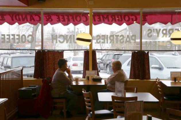
North Dakota Recorded 300 Oil Spills In Two Years Without Notifying The Public. Here's an excerpt of an AP story, picked up by
The Guardian: "
North
Dakota, the nation's No2 oil producer behind Texas, recorded nearly 300
oil pipeline spills in less than two years, state documents show. None
was reported to the public, officials said. According to records
obtained by the Associated Press, the pipeline spills, many of them
small, are among some 750 "oil field incidents" that have occurred since
January 2012 without public notification. "That's news to us," said Don
Morrison, director of the Dakota Resource Council, an
environmental-minded landowner group with more than 700 members in North
Dakota..."
Photo credit above: "
Diners at Kerry's
Kitchen, a restaurant that sits near railroad tracks, in Casselton,
N.D., Jan. 16, 2014. A fiery rail accident last month only a half mile
down the tracks from the restaurant, which prompted residents to
evacuate the town, has shattered people's confidence in the crude--oil
convoys that rumble past seven times a day." (Jim Wilson/The New York Times)
Cost Of Climate Change High On Davos Agenda.
Deutsche Welle has the story - here's a clip: "
From within the Davos Congress Center,
you can see skiers racing down the slopes outside of the World Economic
Forum. Looking at the snow outside, some participants might wonder why
there's so much talk about global warming. Not so Christiana Figueres.
Standing in the snow, the UN climate chief said she is pleased the topic
is so high on the agenda at Davos. "The risk of increased natural
events is there, the risk of a water crisis and the risk for a food
crisis," she told DW, adding that there was economic fallout associated
with failing to deal with climate change and its effects..."
What Affect Does Cold Weather Have On People's Views On Climate Change? We're
hard-wired to react to changes in weather, not the slow-motion, yet
potentially profound, long-term impacts of climate change and climate
volatility. Here's an excerpt from
The Guardian: "
If climate change means higher temperatures, then what are people to make of the brutal cold that continues to cause havoc across the US? Or the fact that only three years ago the UK experienced one of its coldest Decembers for decades, if not centuries? With public concern about climate change stalling in recent years,
these might seem exactly the sorts of weather events likely to generate
sceptical viewpoints, a sign that something is seriously amiss in the
case for climate change. A study I have just had published in the journal Climatic Change suggests however that this way of interpreting extreme cold is actually quite rare..."
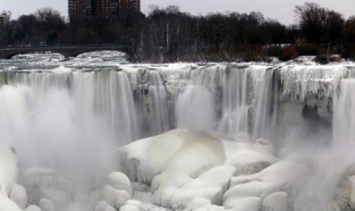
Photo credit above: "
The
US side of Niagara Falls has begun to thaw after being partially frozen
from the recent "polar vortex" that affected millions in the US and
Canada." Photograph: Nick LoVerde/AP.
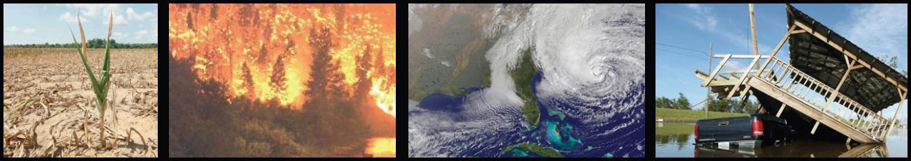 Climate Change Awareness Increases With Extreme Weather Conditions
.
Is the velocity of extreme weather, worldwide, truly increasing? Is it
our imagination - or better reporting? Here's an excerpt from
Science World Report: "...
Bill
Gates also acknowledged the importance of the issue and believes that
there is an awareness problem concerning climate change. Gates
reiterated that since the issues of climate change and development are
interlinked, the focus should not be more prevalent on either individual
subject because it is a collective issue. He also warned of the dangers
of growing prosperity, because as more people begin to afford new uses
of energy, it is paramount that the energy is generated in a clean way
or else the current state of affairs will worsen dramatically..."


No comments:
Post a Comment