By Todd Nelson
I have an itch that a scratch won't reach and I am in need of a little atmospheric acupuncture. This March has had few "Spring-like" signs with temperatures running nearly 8F below average, so some help from Mother Nature would be much appreciated at this point!
March came in like a Polar Bear this year and may go out like a Lion as the next few days look significantly more active than it did to start the month. Not only will folks along the East Coast be dealing with a massive wind storm, but folks in the West are set to get battered by Pacific Moisture through the end of the week. This is great news for areas in California and the Sierra Nevada Range, but flood concerns and additional debris flows are feared in Washington.
One of these Pacific storms breaks loose and drifts our way by late Wednesday. A sloppy rain/snow mix through Thursday reminds us all that it is indeed March. There could be some minor accumulations across parts of Minnesota/Wisconsin, but the strong sun will likely make quick work of that by the weekend.
40s and 50s may be in the offing in the near future. Brace yourself, you might see several jacket-less people. It'll be weird!
===================
TUESDAY NIGHT: Mostly clear and still chilly. Low: 12. Winds: NW 5-10.
WEDNESDAY: Clouds thicken, wintry mix develops in far northern MN late. Warmer and breezy. High: 40. Winds: SSE 10-15.
WEDNESDAY NIGHT: Becomes mostly cloudy with a wintry mix. Low: 35. Winds: SE10-15.
THURSDAY: Rain changes to snow. Les than a half inch. High: 39.
FRIDAY: Sunny start. Clouds thicken late. Wake-up: 19. High: 32.
SATURDAY: A nice Saturday? That's weird... Wake-up: 20. High: 43.
SUNDAY: Warm start. Wintry mix late north. Wake-up: 32. High: 53.
MONDAY: Rain/snow mix potential early. Breezy and cooler. Wake-up: 35. High: 39.
TUESDAY: April Fools' Day. Near average temperatures... we hope! Wake-up: 23. High: 43.
==================
This Day in Weather History
March 26th
2007: Temperature records were shattered across much of central and southern Minnesota and west central Wisconsin. The following records were set: 69 at Alexandria, 75 at Mankato, 77 at Little Falls, 79 at St Cloud, 81 at Minneapolis-St Paul and Eau Claire, 82 at Redwood Falls and 83 at Springfield.
1991: A record of 76 is set at Eau Claire.
===================
Sunrise/Sunset Times
March 26th:
SUNRISE 705 AM
SUNSET 733 PM
================
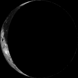
Moon Phase at Midnight March 26th
3.5 Days Before New Moon
==============
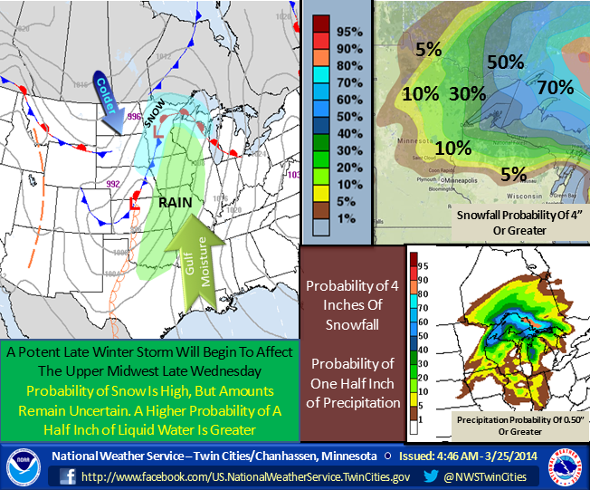
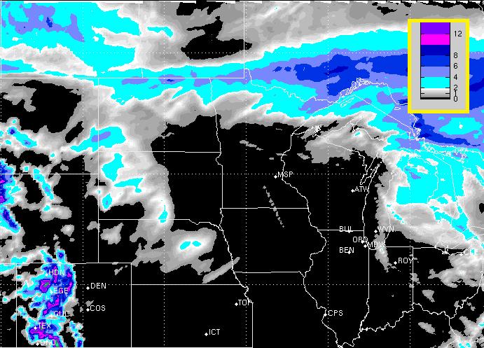
Weather Outlook
Here's a good outline of what we can expect with this next storm system as it moves in PM Wednesday through Thursday.
"A storm system will begin to affect the Upper Midwest late Wednesday night. The precipitation will likely begin as rain, then change over to snow by Thursday afternoon and evening. The highest probability of 4 inches or more of snow will occur north and east of the Twin Cities Metro area, but some snow is likely before the system exits the region Friday morning. Total precipitation amounts could exceed one half inch across a good portion of eastern Minnesota, and western Wisconsin."
(Image courtesy: NWS Twin Cities)
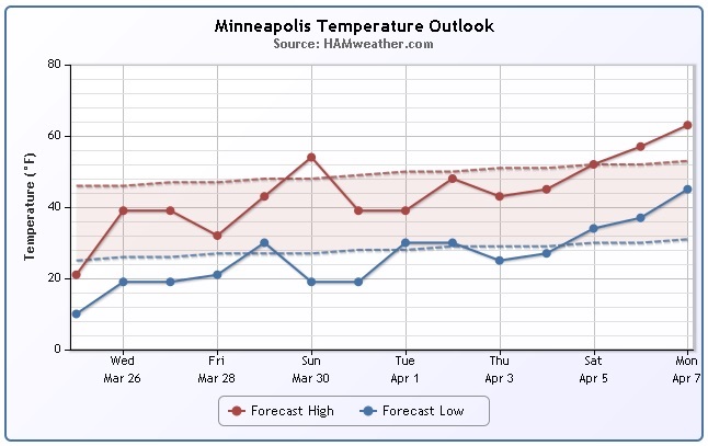
Minneapolis Temp Trend
We're still looking at a fairly gradual, but decent warm up over the next several days... At least we're going to be closer to average and hey, there's even a chance that we could climb to above average levels over the coming days!
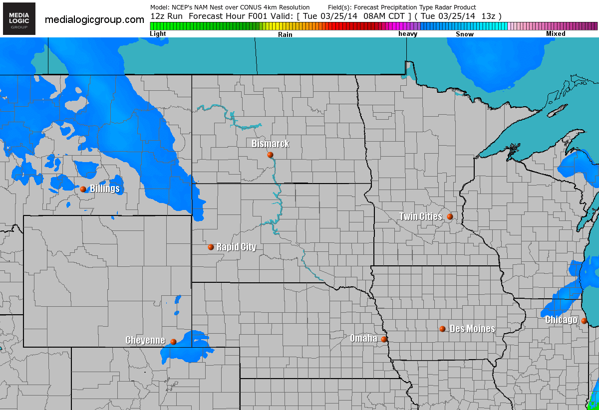
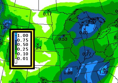
Weather Outlook
Here's a look at our next storm system as it moves in to the Midwest. Note that there appears to be a brief wintry mix early Wednesday as the warmer air streams in across the area. Clouds thicken further by PM Wednesday with more wintry precipitation developing. The best chance of more widespread rain/snow will be Thursday as the center of low pressure slides in across the region.
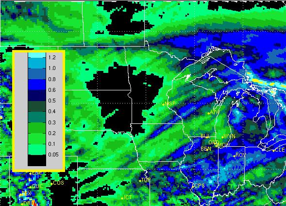
Snow Potential
According to the RPM model, the best chance of snow accumulations will be across the far northern reaches of the state of Minnesota.
Rain Potential
Interestingly, most of the precipitation with this particular system looks to fall in the form of just rain on the southern side the storm.
==========================
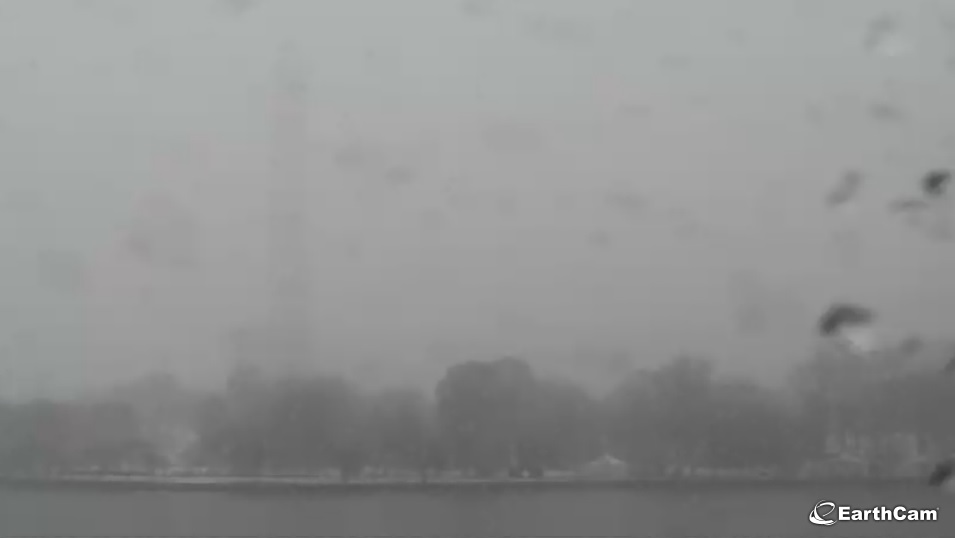
Cherry Blossom Festival Continues
YIKES! The EarthCam view from Washington D.C. showed a pretty dank view on Tuesday. You can kind of make out the Washington Monument... Keep in mind that the annual Cherry Blossom Festival is currently in session.
Here's more from the National Cherry Blossom Festival:
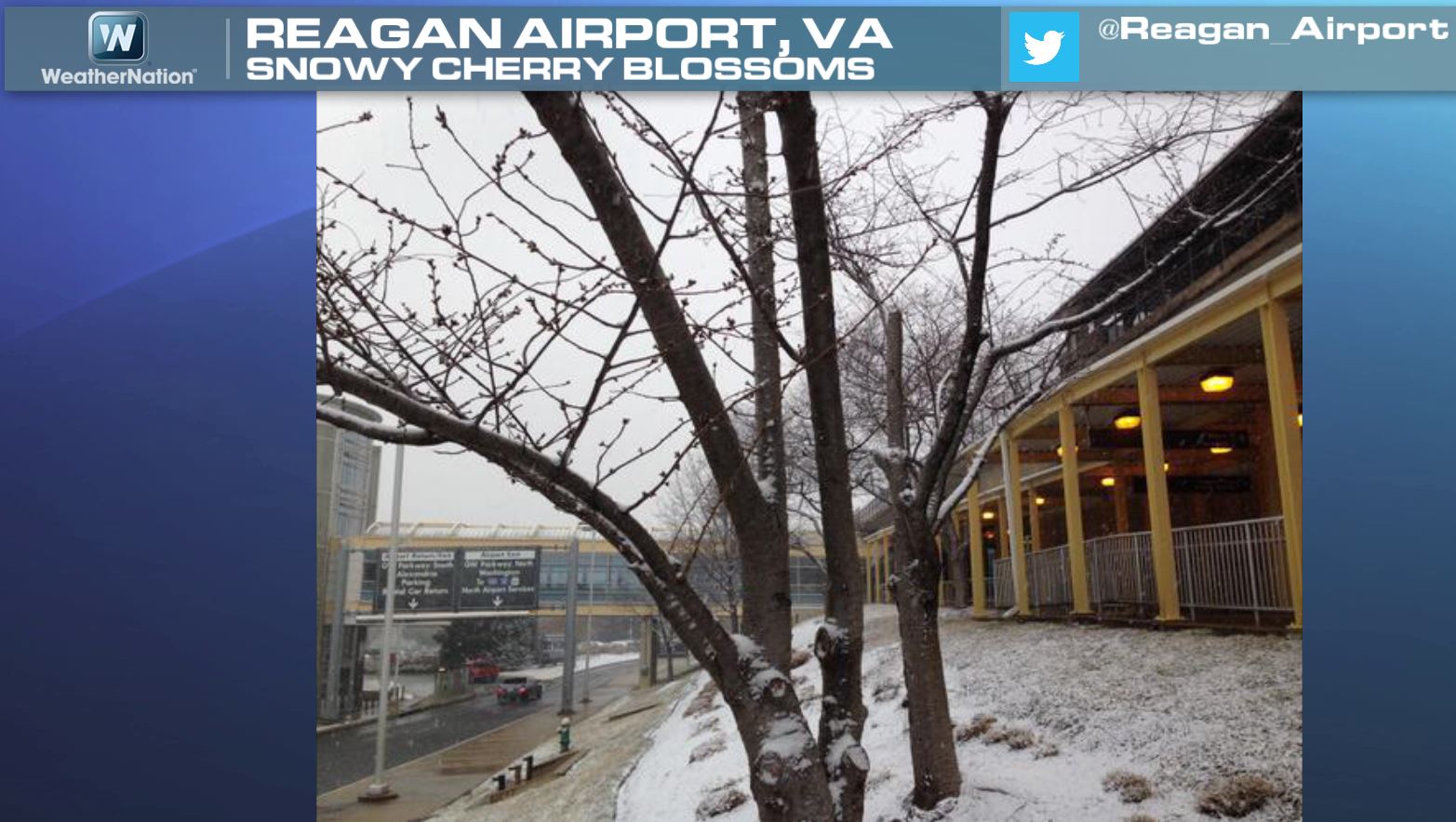
Here was the view from the Reagan National Airport in Virgina. This particular view from Tuesday showed a little snow on the ground along with the buds trying hard to pop out! Unfortunately, they're not getting any help from Mother Nature.
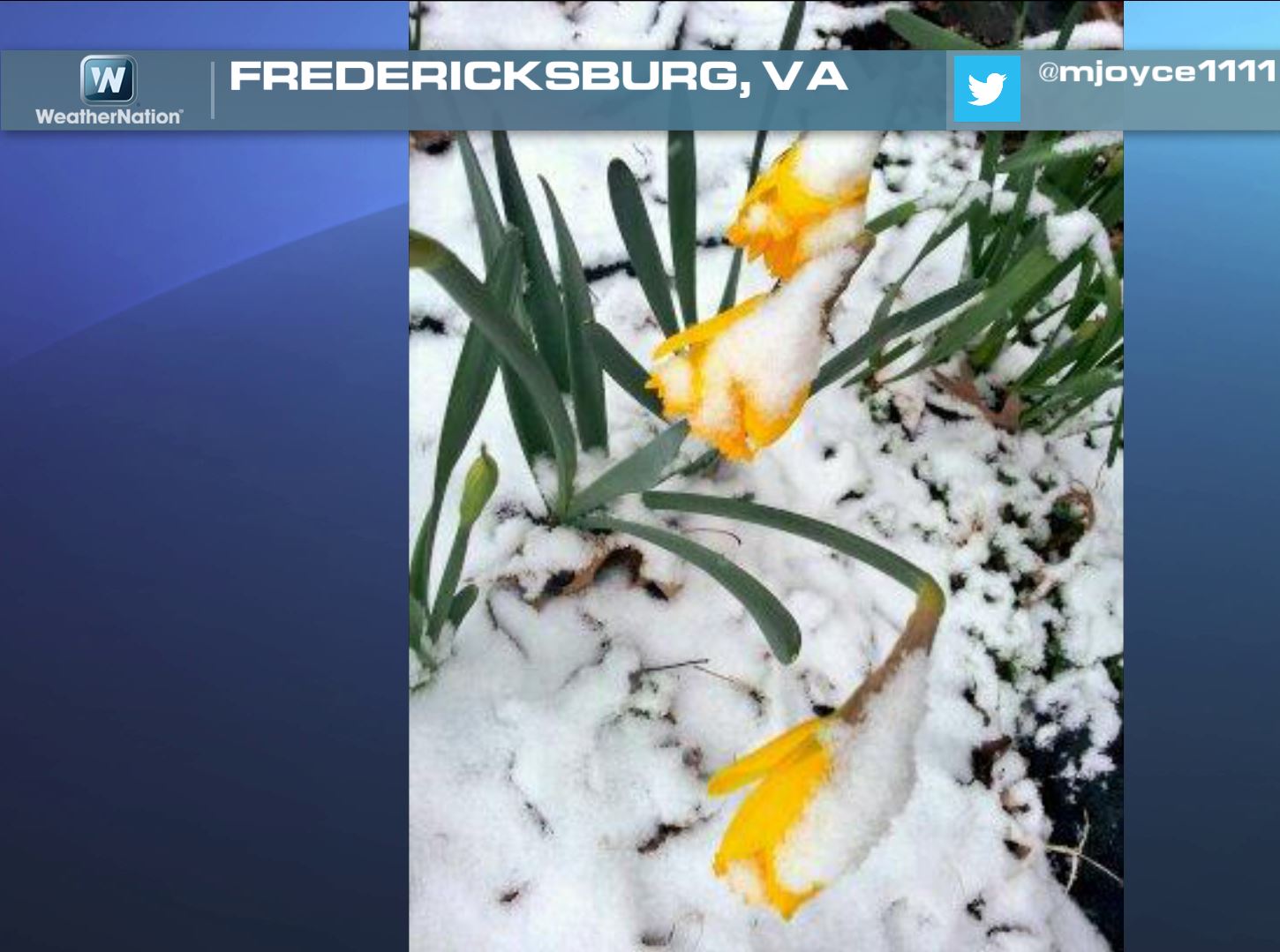
Seasonal Dysfunction
Those poor flowers in Fredericksburg, VA look like they had a tough day Tuesday. Thanks @mjoyce111 for the picture. Hope they didn't freeze their buds off!
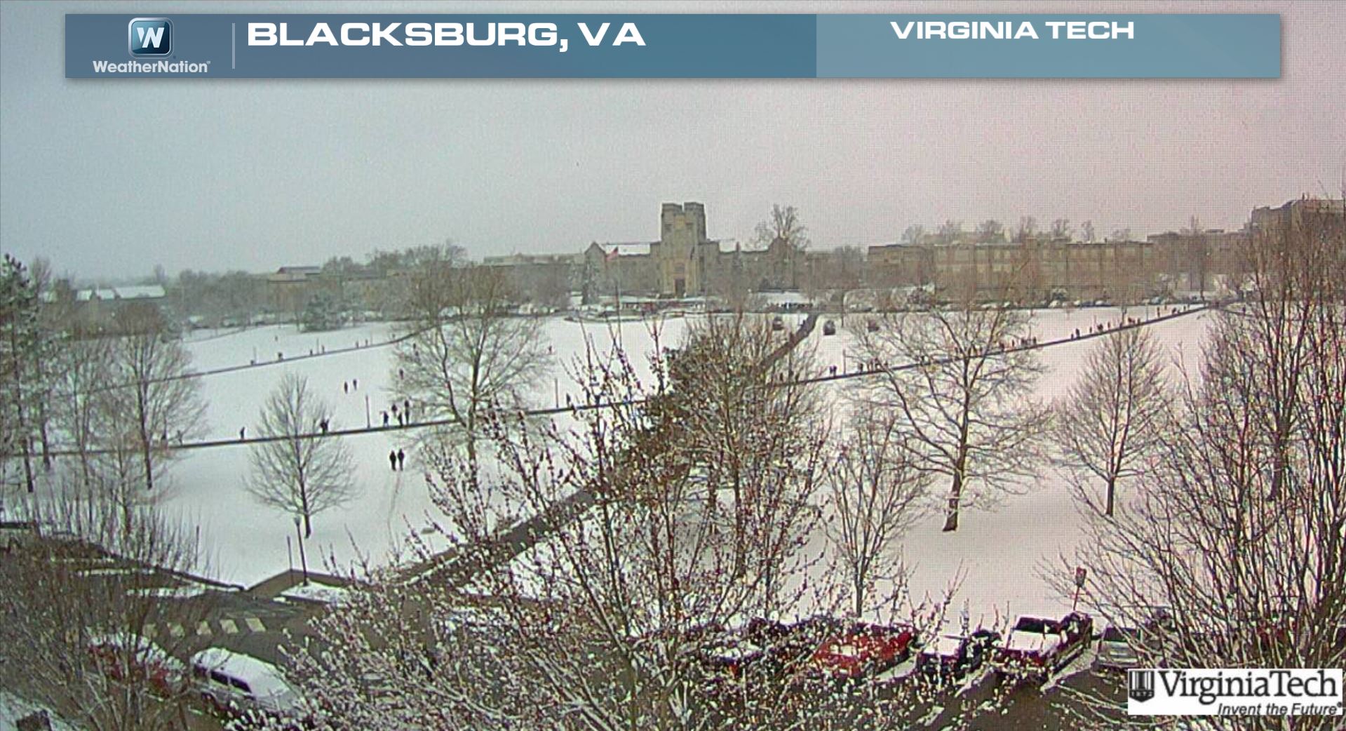
Snowy View From Virginia Tech
The webcam from Virginia Tech looked quite interesting on Tuesday afternoon too. Interestingly, this webcam looked very "springy" this weekend with green grass and pink flower buds showing up on trees.
Key West Flooding
Thanks to @mrphew for the picture from Key West, FL where heavy rains on Tuesday caused some flooding issues.

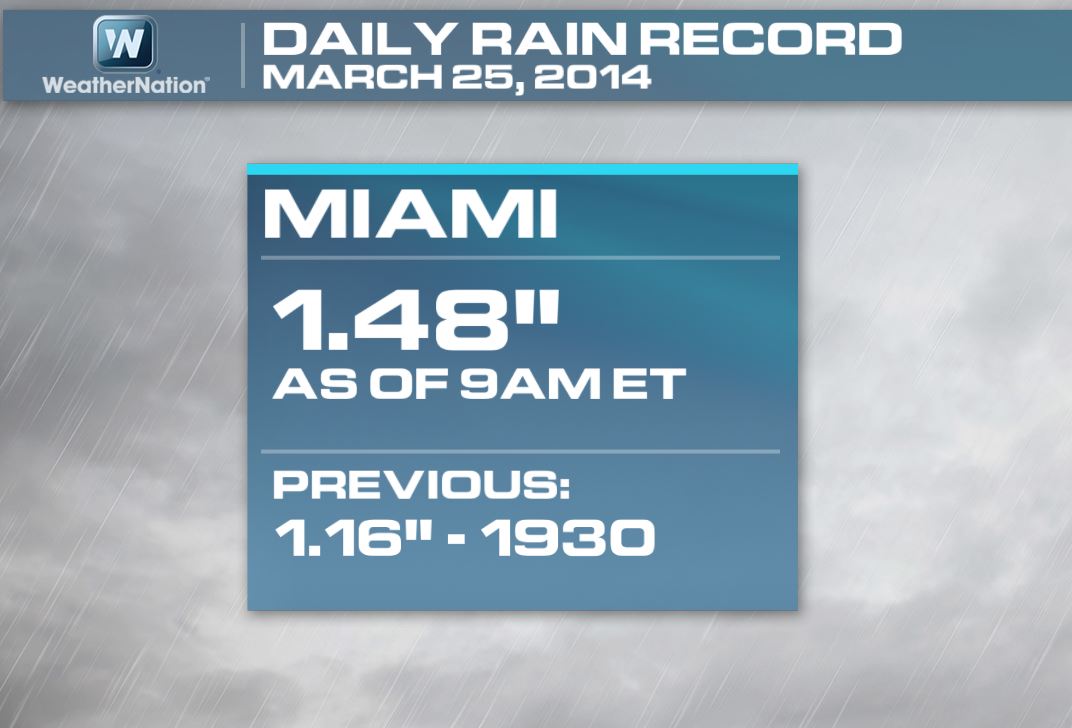
Miami Rainfall Record
Heavy rainfall across southern Florida on Tuesday led to daily rainfall record in Miami on Tuesday, March 25th. As of 9am, Miami had 1.48" of rain, which beat the old record of 1.16" set in 1930
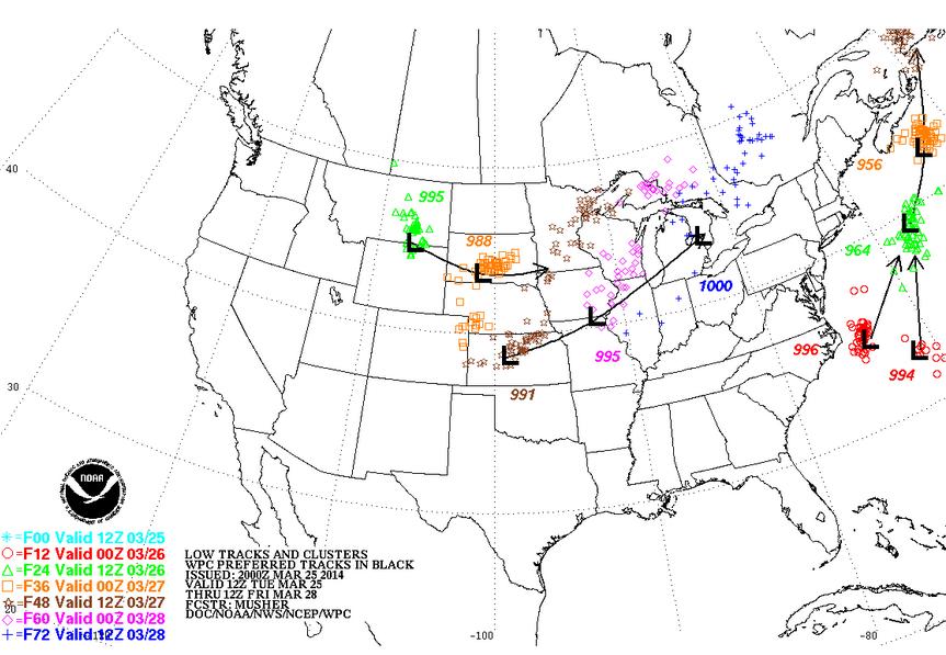
East Coast Storm "Bombs" Out!
Believe it or not, the areas that I mentioned above are from two separate areas of low pressure that are set to merge and go through a process known as "Bombogenesis". This process is classified as an area of low pressure that intensifies rapidly, but has to meet the criteria of at least a 24millibar drop within 24 hours. Some models show the central pressure to nearly double that heading into Wednesday! The image below shows the storm system of interest off the East Coast. Note the two lows (in red), this is the low pressure center around 7pm Tuesday (forecast average central pressure of 995mb). Note that 24 hours later (in yellow) at 7pm Wednesday, the forecast central pressure of the low will be around 956mb! That' a drop of nearly 40mb in 24 hours!
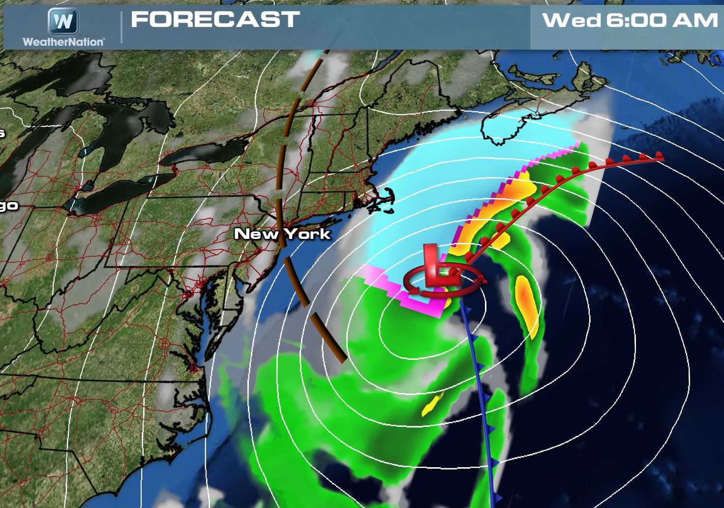
Storm at 6am Wednesday
Here's the storm forecast by 6am Wednesday, note the white lines surrounding the low pressure, these are lines of equal air pressure and the more lines you see packed tightly around an area of low pressure dictates the strength of the wind. The winds at this point could already be gusting to 60mph+ over the open water! Also, the snow appears to be just clipping the southeastern part of Massachusetts at this point.
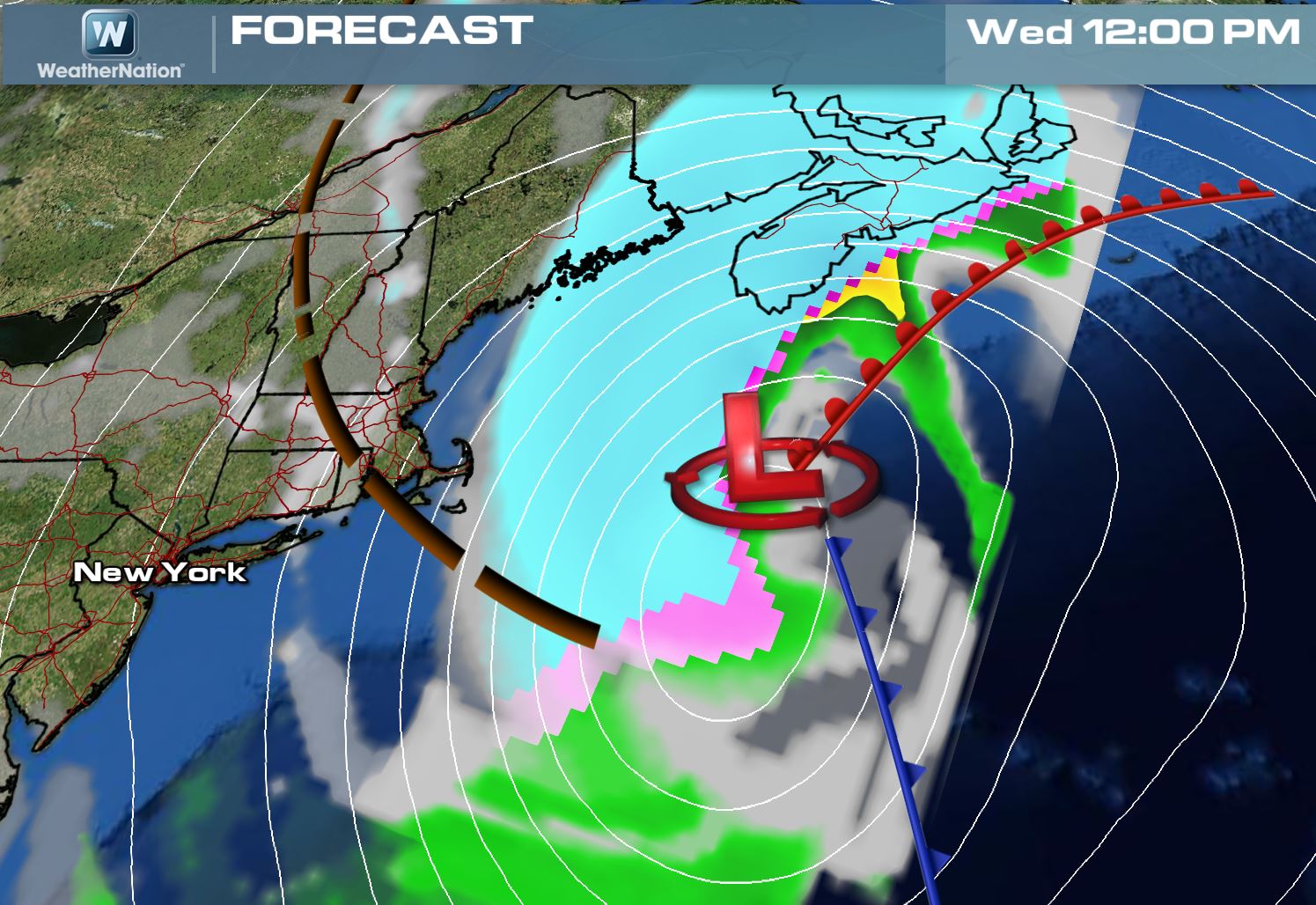
Storm at 12pm Wednesday
By midday Wednesday, the storm appears to be quickly moving north/northeast towards Nova Scotia. The wind field surrounding this low pressure system looks to still be kicking up pretty good. At this point, the heavy snow will have already moved into the eastern portions of Maine.
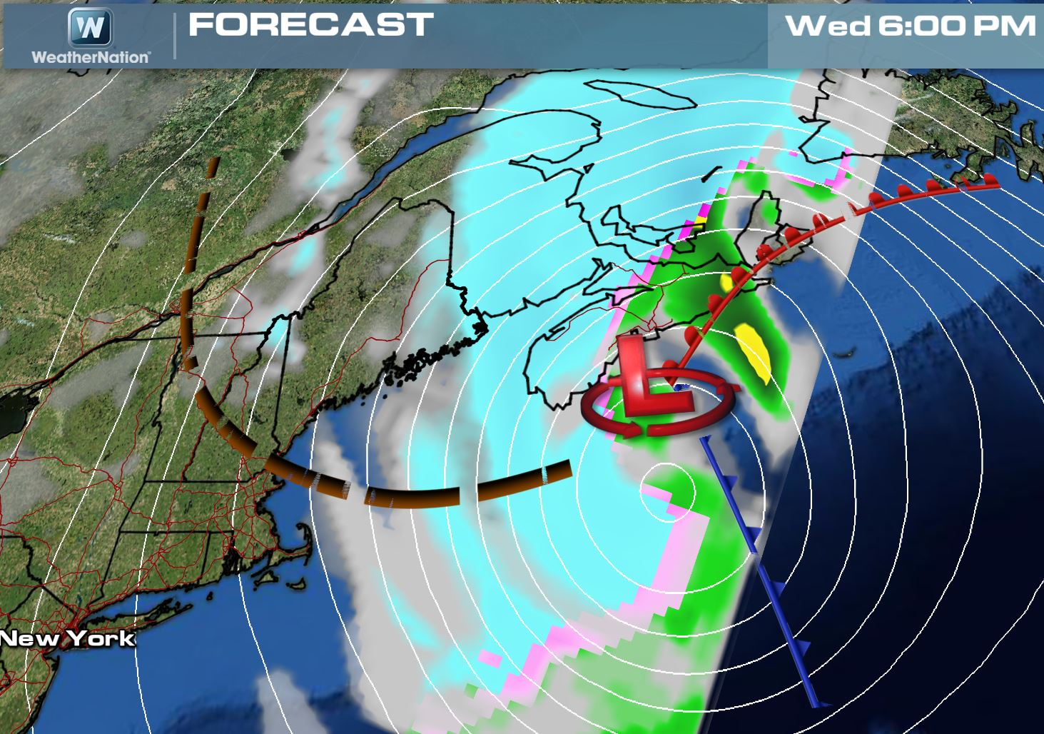
Storm at 6pm Wednesday
Another 6 hours forward and the snow looks to be nearly wrapped up over Massachusetts, but some lingering snow showers can't be ruled out over the far northern New England region and parts of Maine. The wind however will still be roaring!
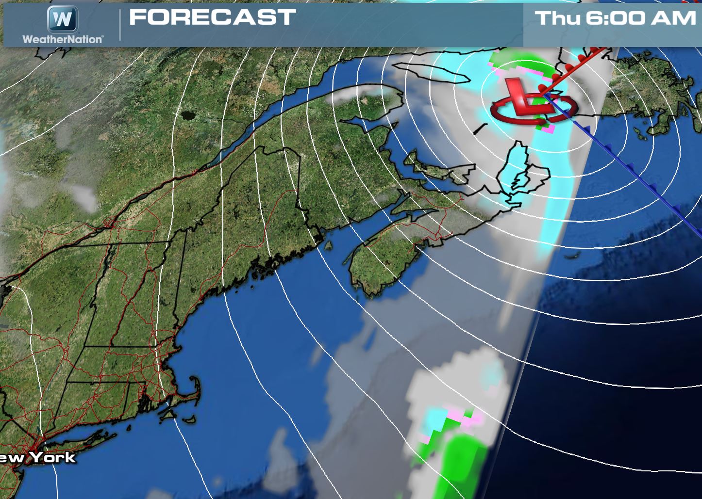
Storm @ 6am Thursday
The snow threat by Thursday morning looks to be pretty much wrapped up, but the gusty winds will still be in place for the far northeastern part of the nation.
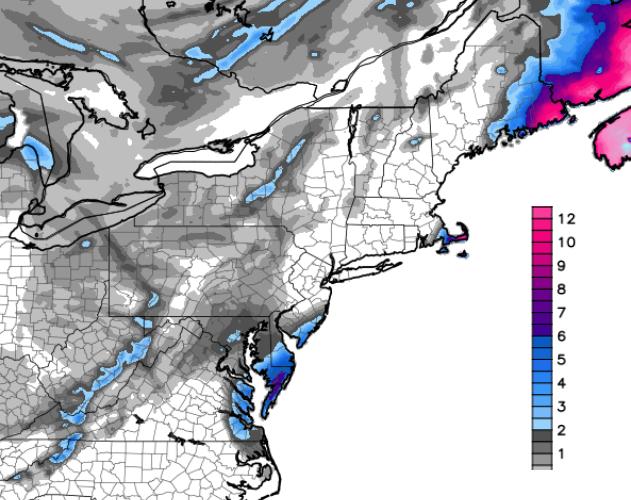
Snowfall Potential
Other than the significant winds, it appears that (most) of us have dodged a major bullet with this storm! The snowfall looks to be the heaviest right along the coast, but it will be increasing dramatically as you head north towards the eastern part of Maine. The image below (courtesy WeatherBell) show the snowfall potential through Wednesday night.
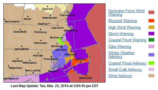
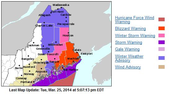
National Weather Service Weather Headlines
Here are all the winter weather headlines that have been posted for the upcoming event.
See more from a specific National Weather Service Office HERE:
Boston, MA
...BLIZZARD WARNING IN EFFECT FROM MIDNIGHT TONIGHT TO 2 PM EDT WEDNESDAY... THE NATIONAL WEATHER SERVICE IN TAUNTON HAS ISSUED A BLIZZARD WARNING...WHICH IS IN EFFECT FROM MIDNIGHT TONIGHT TO 2 PM EDT WEDNESDAY. THE BLIZZARD WATCH IS NO LONGER IN EFFECT. * LOCATIONS...CAPE COD...NANTUCKET AND MARTHA/S VINEYARD. * HAZARD TYPES...HEAVY SNOW...STRONG DAMAGING WINDS AND BLIZZARD CONDITIONS. * ACCUMULATIONS...SNOW ACCUMULATION OF 5 TO 10 INCHES WITH THE HIGHER AMOUNTS EXPECTED ACROSS THE OUTER-CAPE AND NANTUCKET. * TIMING...SNOW DEVELOPS BETWEEN 10 PM AND MIDNIGHT. THE HEAVIEST SNOW WILL FALL FROM 2 AM UNTIL NOON...TAPERING OFF DURING THE AFTERNOON. * IMPACTS...HEAVY SNOW AND STRONG WINDS WILL RESULT IN NEAR ZERO VISIBILITIES AT TIMES VERY LATE TONIGHT INTO WEDNESDAY. TRAVEL MAY BECOME IMPOSSIBLE AT TIMES...ESPECIALLY DURING THE WEDNESDAY MORNING RUSH HOUR. NORTHERLY WIND GUSTS BETWEEN 60 AND 70 MPH WILL RESULT IN DOWNED TREES AND POWER OUTAGES. THIS IS A DANGEROUS STORM AND TRAVEL IS NOT RECOMMENDED. * WINDS...NORTH 30 TO 40 MPH WITH GUSTS BETWEEN 60 AND 70 MPH. * TEMPERATURES...AROUND 30. * VISIBILITIES...ONE QUARTER MILE OR LESS AT TIMES.
Portland, ME
...STORM WARNING REMAINS IN EFFECT FROM 8 AM TO 9 PM EDT WEDNESDAY... * WINDS...NORTH 35 TO 45 KT WITH GUSTS UP TO 65 KT. * SEAS...12 TO 17 FEET. PRECAUTIONARY/PREPAREDNESS ACTIONS... A STORM WARNING MEANS WINDS OF 48 TO 63 KNOTS ARE IMMINENT OR OCCURING. RECREATIONAL BOATERS SHOULD REMAIN IN PORT...OR TAKE SHELTER UNTIL WINDS AND WAVES SUBSIDE. COMMERCIAL VESSELS SHOULD PREPARE FOR VERY STRONG WINDS AND DANGEROUS SEA CONDITIONS...AND CONSIDER REMAINING IN PORT OR TAKING SHELTER IN PORT UNTIL WINDS AND WAVES SUBSIDE.
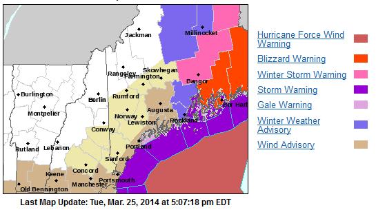
Caribou, ME
THE NATIONAL WEATHER SERVICE IN CARIBOU HAS ISSUED A BLIZZARD WARNING...WHICH IS IN EFFECT FROM 6 AM WEDNESDAY TO MIDNIGHT EDT WEDNESDAY NIGHT. THE BLIZZARD WARNING REPLACES THE WINTER STORM WARNING. * SNOW ACCUMULATIONS...8 TO 12 INCHES. * LOCATIONS...INTERIOR HANCOCK AND NORTHERN WASHINGTON COUNTIES. * HAZARD TYPES...HEAVY SNOW AND BLOWING AND DRIFTING SNOW. * TIMING...WEDNESDAY MORNING THROUGH WEDNESDAY EVENING. * IMPACTS...HEAVY SNOW WITH CONSIDERABLE BLOWING AND DRIFTING SNOW WILL LEAD TO BLIZZARD CONDITIONS AT TIMES. ROADS COULD BECOME IMPASSABLE. * WINDS...NORTH 20 TO 30 MPH WITH GUSTS UP TO 50 MPH. * TEMPERATURES...IN THE LOWER TO MID 20S. * VISIBILITIES...LESS THAN ONE QUARTER MILE AT TIMES.
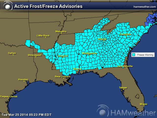
Cold Night Ahead in the Southeast
Spring has sprung for some in the Southeast, so it's important to keep those new plants protected (if you want to keep them around). The National Weather Service has issued widespread freeze warnings for Tuesday night/AM Wednesday as temperatures could dip into the 20s and lower 30s for several hours in the areas highlighted below.
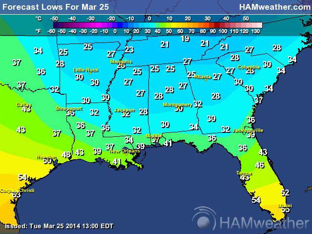
Forecast Lows Tonight
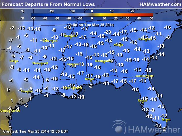
Forecast Lows From Normal
Nice Weather Fades in Seattle
Thanks to my good friend Aaron Theis for the picture below. He snapped this picture on Monday in Seattle, WA prior to the weather souring on Tuesday. Places in the West will have some pretty unruly weather over the next few days.

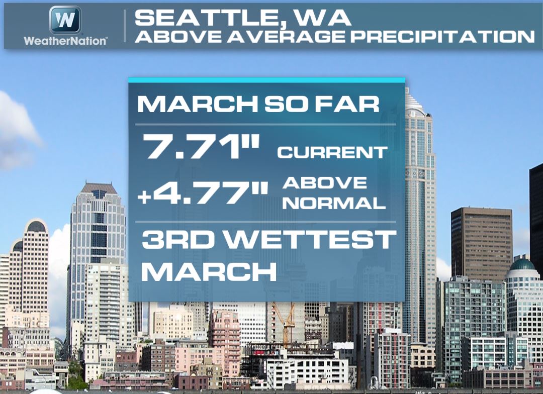
Seattle 3rd Wettest March on Record
Did you know that as of Monday, Seattle has seen 7.71" of precipitation this March? We're are 4.77" above normal precipitation and are considered to be at the 3rd wettest March in recorded history!
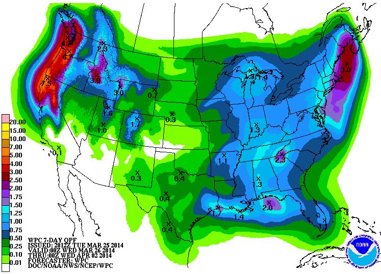
Precipitation Forecast Next 7 Days
According to NOAA's HPC the 7 day precipitation forecast for the West Coast looks quite impressive! Note the near 5" to 7"+ maximums. Unfortunately, this additional moisture is not necessarily a good thing at this point for folks near the community of Oso, WA. With the additional heavy precipitation in the forecast, the fear is that additional debris flows can't be ruled out!
Washington Flood Concerns
* FLOOD WARNING FOR THE NORTH FORK STILLAGUAMISH RIVER IN NORTH CENTRAL SNOHOMISH COUNTY... * UNTIL 530 PM PDT TUESDAY. * THE LANDSLIDE THAT BLOCKED THE NORTH FORK OF THE STILLAGUAMISH RIVER SINCE SATURDAY MORNING HAS BACKED UP WATER UPSTREAM OF THIS LANDSLIDE EAST OF OSO. THE POOLING WATER IS CAUSING MINOR FLOODING OF HOMES AND ROADS IN THIS AREA. THE FLOODING WILL CONTINUE UNTIL THE NEW RIVER CHANNEL IS BIG ENOUGH TO DRAIN THE LAKE FORMED BEHIND THE BLOCKAGE. WE WILL BE UPDATING THE FLOOD WARNING ON A DAY TO DAY BASIS. * FORECAST...WATER BEGAN TO MOVE THROUGH THE SLIDE AREA YESTERDAY AFTERNOON AND THIS HAS CONTINUED THROUGH EARLY THIS MORNING. DOWNSTREAM GAGES ON THE STILLAGUAMISH RIVER HAVE RISEN BACK TO NEAR WHERE THEY WERE BEFORE THE BLOCKAGE OCCURRED. THIS MEANS THE POOL OF WATER UPSTREAM OF THE OSO AREA LANDSLIDE HAS SIGNIFICANTLY SLOWED ITS RATE OF INCREASE AND PROBABLY HAS STOPPED GROWING ALTOGETHER. THE FLOOD WARNING WILL CONTINUE UNTIL THERE IS CONFIRMATION THAT FLOODING HAS ENDED.

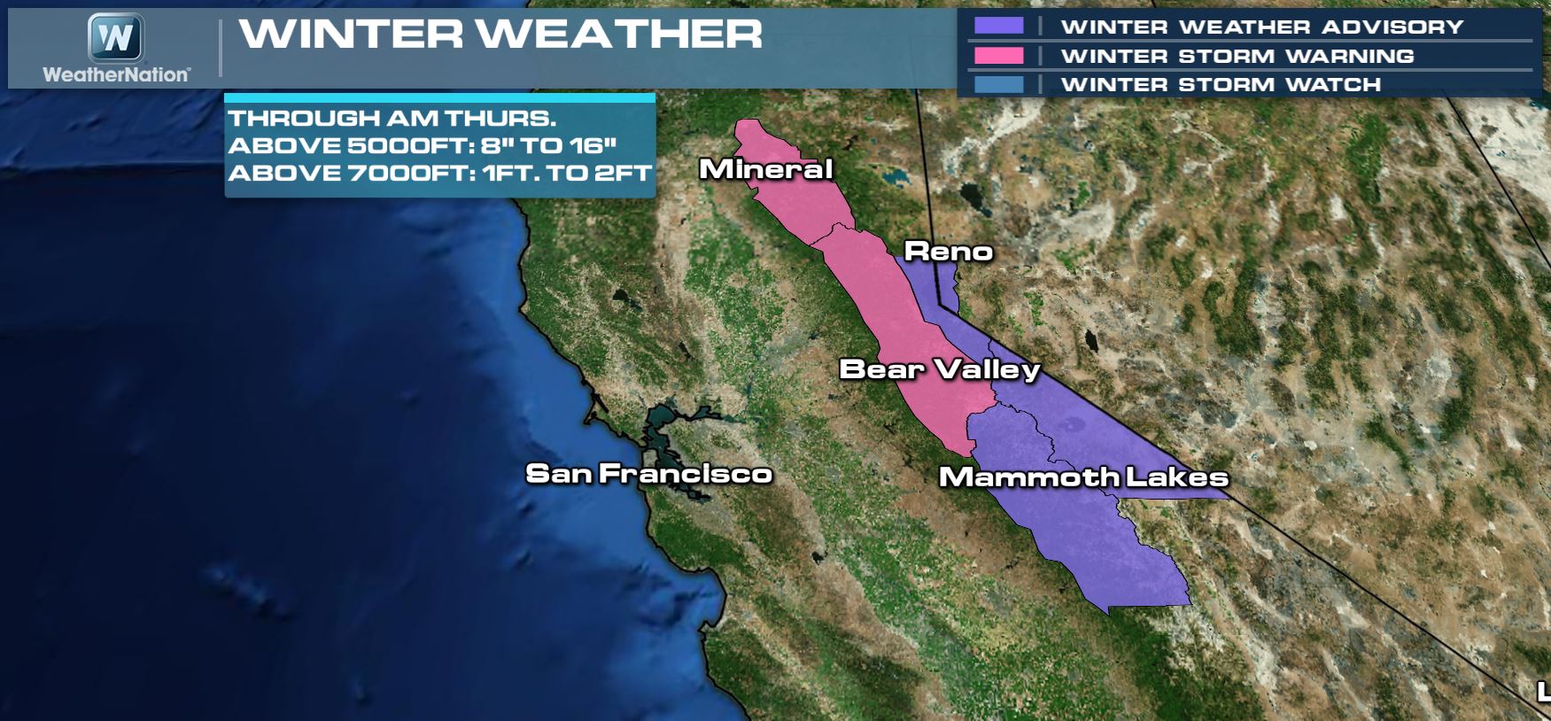
Sierra Snow Potential
The heavy Pacific moisture is not all bad though! The Sierra Nevada Range could see as much as 1ft. to 2ft. of snow by the time this is all said and done later this week!
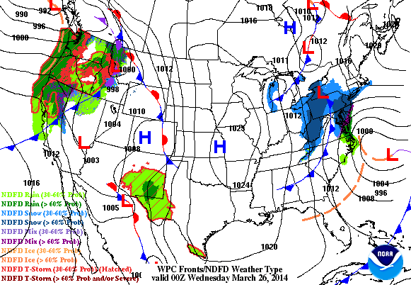
Late Week Storm
An impulse of energy will break off and head into the central part of the country for the 2nd half of the week. Heavier rain/snow and possibly even some severe weather can't be ruled out. Note the large storm that appears to be moving into the middle part of the country by PM Thursday.
Severe Threat
Here's the outlook from NOAA's SPC:
...SYNOPSIS... MODELS CONTINUE TO INDICATE THAT MID/UPPER FLOW WILL BECOME GENERALLY ZONAL ACROSS MUCH OF THE U.S. BY THURSDAY...WITH A BELT OF WESTERLIES EMERGING FROM THE MID LATITUDE PACIFIC MOST PROMINENT. WITHIN THIS REGIME...THE REMNANTS OF AN INLAND ADVANCING LARGER SCALE TROUGH APPEAR LIKELY TO CONTINUE EASTWARD ACROSS THE INTERIOR U.S...INCLUDING ONE SIGNIFICANT IMPULSE THAT MAY CONTRIBUTE TO A DEVELOPING SURFACE LOW OVER THE CENTRAL PLAINS BY 12Z THURSDAY...BEFORE TRACKING TOWARD THE GREAT LAKES REGION THROUGH THE REMAINDER OF THE PERIOD. GIVEN THE PROGRESSIVE NATURE OF THIS SYSTEM NOW EVIDENT IN MOST MODEL GUIDANCE...IT STILL APPEARS MOST PROBABLE THAT STRONGER MID/UPPER FORCING FOR UPWARD VERTICAL MOTION AND DEEP LAYER MEAN FLOW FIELDS WILL BEGIN SHIFTING AWAY FROM THE GULF COAST REGION BEFORE GULF BOUNDARY LAYER MODIFICATION AND INLAND RETURN FLOW IS ABLE TO YIELD A SEASONABLY MOIST WARM SECTOR. BUT A WINDOW OF OPPORTUNITY DOES APPEAR TO EXIST FOR MODEST WARM SECTOR MOISTENING AND DESTABILIZATION...WHICH SHOULD SUPPORT POTENTIAL FOR SEVERE STORM DEVELOPMENT...PRIMARILY FROM THE LOWER CENTRAL PLAINS THROUGH THE MIDDLE MISSISSIPPI VALLEY AND OZARK PLATEAU...FROM MIDDAY THURSDAY INTO THURSDAY EVENING.

Thanks for checking in and have a great rest of your week! Don't forget to follow me on Twitter @TNelsonWNTV

No comments:
Post a Comment