By Todd Nelson
It seems as if something gave Mother Nature a shot of caffeine here as of late. Until just recently, it seemed as if we were just muddling through March. It came in like a polar bear and looks to go out like a lion. Weather maps look busy Thursday and again Monday across
the Upper Midwest, both storms responsible for rain changing over to sloppy snow accumulations. The good news is that at this time of the year, snow has a hard time sticking around after it falls.
The official snow depth observation from the Minneapolis/St. Paul International Airport early this week still had 2" of snow on the ground. This is down from the maximum of 24", which was observed on February 21st, nearly 1 month ago. Last year, we had snow on the ground until the middle of April, but in 2012, we lost our snow cover by March 7th as temperatures soared into the 70s and 80s much of the month.
Keep in mind that March is typically our 3rd snowiest month of the year with nearly 11" of
snow. March 2014 has seen around 4.5", which is about 4.5" below average. We could pad those stats by the end of the day Thursday and again perhaps next Monday... March out like a lion.
Silver lining? 50s possible Sunday!
=========================
WEDNESDAY NIGHT: Becoming mostly cloudy with light rain. Low: 35. Winds: SE10-15.
THURSDAY: Rain changes to snow. Slushy 1" to 3" possible (most melting on contact). High: 40, falling later. Winds: Turning NNW 10-20.
THURSDAY NIGHT: Breezy and cooler. Lingering snow early, clearing trend. Low: 18. Winds: NW 10-15.
FRIDAY: Quiet with less wind and more sun. High: 32.
SATURDAY: A nice Saturday? A bit breezy, but warmer! Wake-up: 18. High: 42.
SUNDAY: Above average temperatures... that's weird! Wake-up: 32. High: 52.
MONDAY: Growing risk of rain/snow mix. Wake-up: 32. High: 37.
TUESDAY: April Fools' Day. Sunny start... we hope! Wake-up: 18. High: 38.
WEDNESDAY: Another rain/snow chance? Wake-up: 26. High: 39.
========================
This Day in Weather History
March 27
1946: A record of 78 is set at Redwood Falls.
=======================
Sunrise/Sunset Times:
March 27
SUNRISE 703 AM
SUNSET 734 PM
======================
Moon Phase at Midnight on March 27th
2.5 Days Before New Moon

=======================
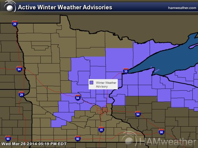
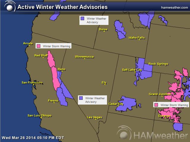
Winter Weather Advisory Thru 10pm Thursday
...ACCUMULATING SNOW EXPECTED THURSDAY IN CENTRAL MINNESOTA...
.ANOTHER WINTER STORM WILL BRING ACCUMULATING SNOW TO MINNESOTA AND WESTERN WISCONSIN LATER TONIGHT THROUGH THURSDAY EVENING. WARM AIR WILL SURGE NORTH AND PRECIPITATION WILL START AS RAIN. AS COLD AIR MOVES IN FROM THE NORTHWEST...THE RAIN WILL CHANGE TO SNOW AND ACCUMULATE. BY THE MORNING COMMUTE...EXPECT SNOW TO BE ACCUMULATING FOR AREAS OF CENTRAL MINNESOTA. TRAVEL WILL BE IMPACTED. THE CHANGE OVER TO SNOW WILL PROGRESS EAST THURSDAY. A TOTAL OF 3 TO 5 INCHES OF SNOW IS EXPECTED. WINDS WILL INCREASE THURSDAY AFTERNOON AND EVENING AND GUSTS TO 30 MPH WILL CAUSE BLOWING AND DRIFTING SNOW. IMPROVING CONDITIONS WILL OCCUR AFTER MIDNIGHT.
...WINTER WEATHER ADVISORY IN EFFECT FROM 4 AM TO 10 PM CDT THURSDAY...
THE NATIONAL WEATHER SERVICE IN TWIN CITIES/CHANHASSEN HAS ISSUED A WINTER WEATHER ADVISORY FOR HEAVY SNOW...WHICH IS IN EFFECT FROM 4 AM TO 10 PM CDT THURSDAY.
* RAIN WILL CHANGE TO SNOW THURSDAY MORNING AND BEGIN TO ACCUMULATE.
* SNOWFALL RATES COULD BE AN INCH PER HOUR.
* TOTAL SNOW AMOUNTS OF 3 TO 5 INCHES ARE EXPECTED.
* WINDS WILL INCREASE THURSDAY AFTERNOON AND CAUSE BLOWING AND DRIFTING SNOW. GUSTS AROUND 30 MPH ARE EXPECTED.
* PLAN ON HAZARDOUS TRAVEL...ESPECIALLY DURING COMMUTE TIMES.
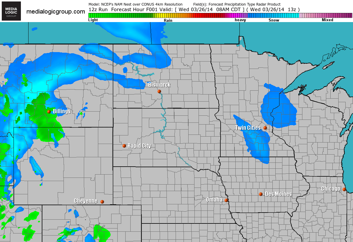
Rain Changes to Snow
Here's our Thursday storm system. Note that the best chance for a steadier snow will be across northern Minnesota/northern Wisconsin. There appears to be a quick changeover from rain to snow near the Twin Cities, which could help to bring in some slushy accumulations across central Minnesota and perhaps even into the Twin Cities.
Snow Potential
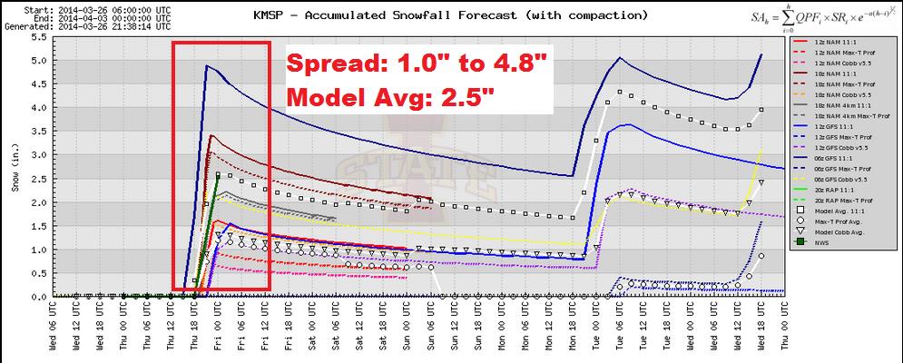
Model Data
Here are the raw numbers from a different number of weather models for the Twin Cities. Note the spread is from around 1" to almost 5". The model average is 2.5". At this point, I feel pretty comforable with a slushy 1" to 3" of snow across the Twin Cities, with the best chance of 3" to 5" across central Minnesota. Keep in mind that some of this will be melting as it falls initially, so that could cut totals down a bit.
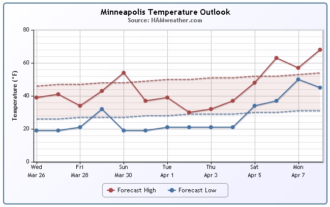
Minneapolis Temperature Trend
As of Tuesday, March 25th the average temperature for Minneapolis was running nearly 8.5F below average. It appears that we'll end the month of March with below average temperatures, but we should be able to chip away at that temperature deficit over the coming days as temperatures warm a bit. Note the quick spike on Sunday! Temperatures then could sneak up into the 50s... Cross your fingers!
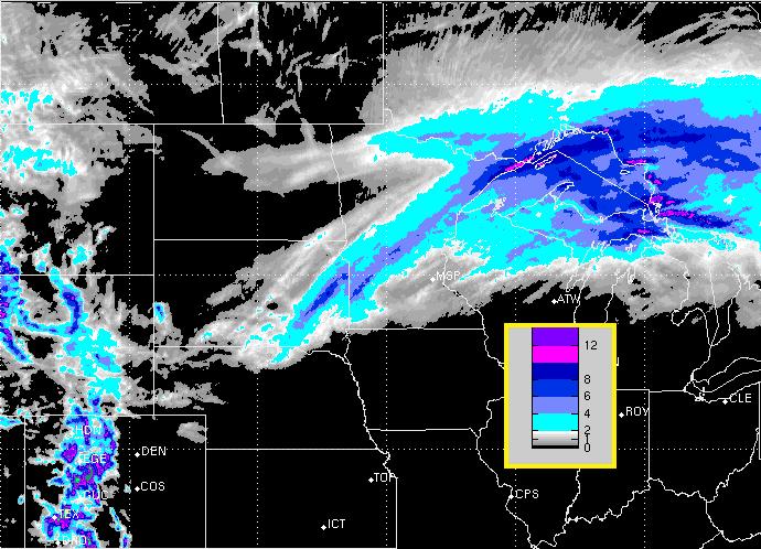
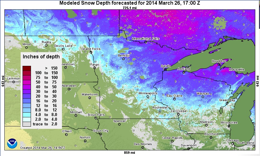
Midwest Snow Depth
As of Wednesday, here was the modeled snow depth across the Midwest. Note that the largest snow depths were still being found across NE Minnesota, N Wisconsin and the U.P. of Michigan.
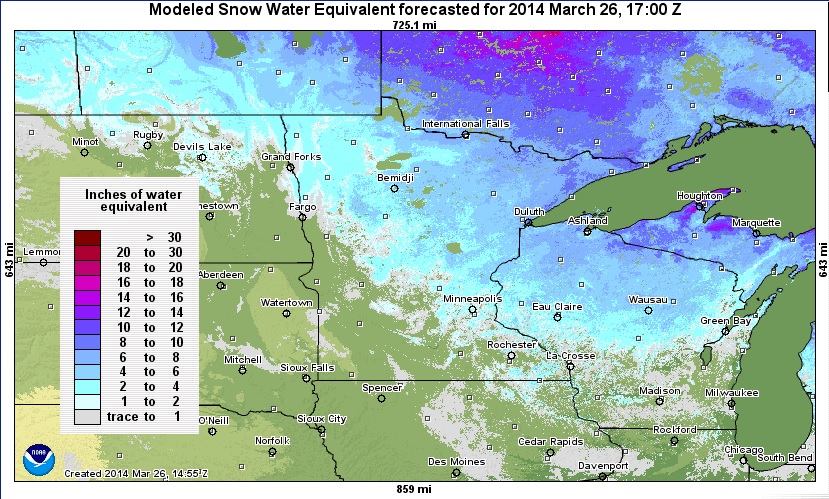
SWE
SWE is considered to be Snow Water Equivalent, which is a term to describe how much water is locked in the snow pack. This number is especially important during the Spring flooding time frame. Note that there is quite a bit more water locked in the snow where the snow depth is the greatest.
===============================
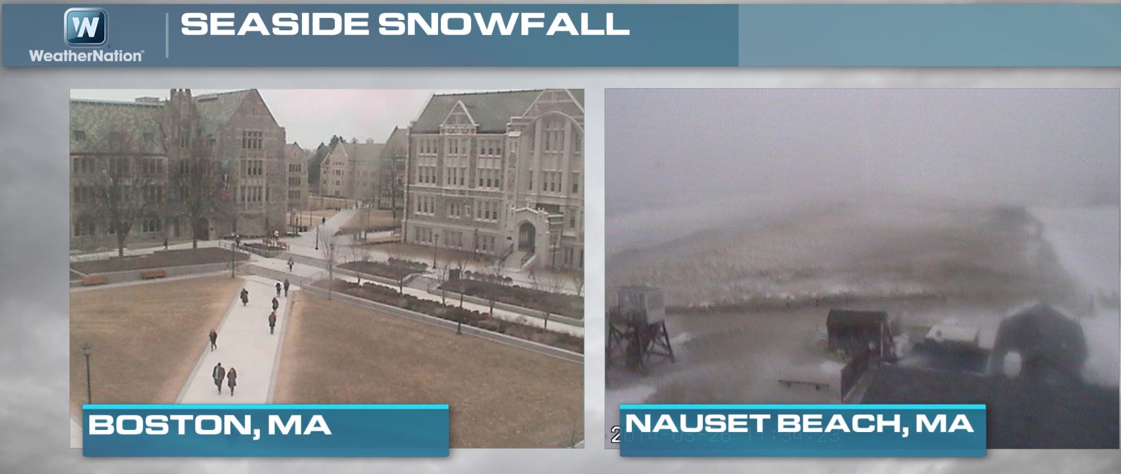
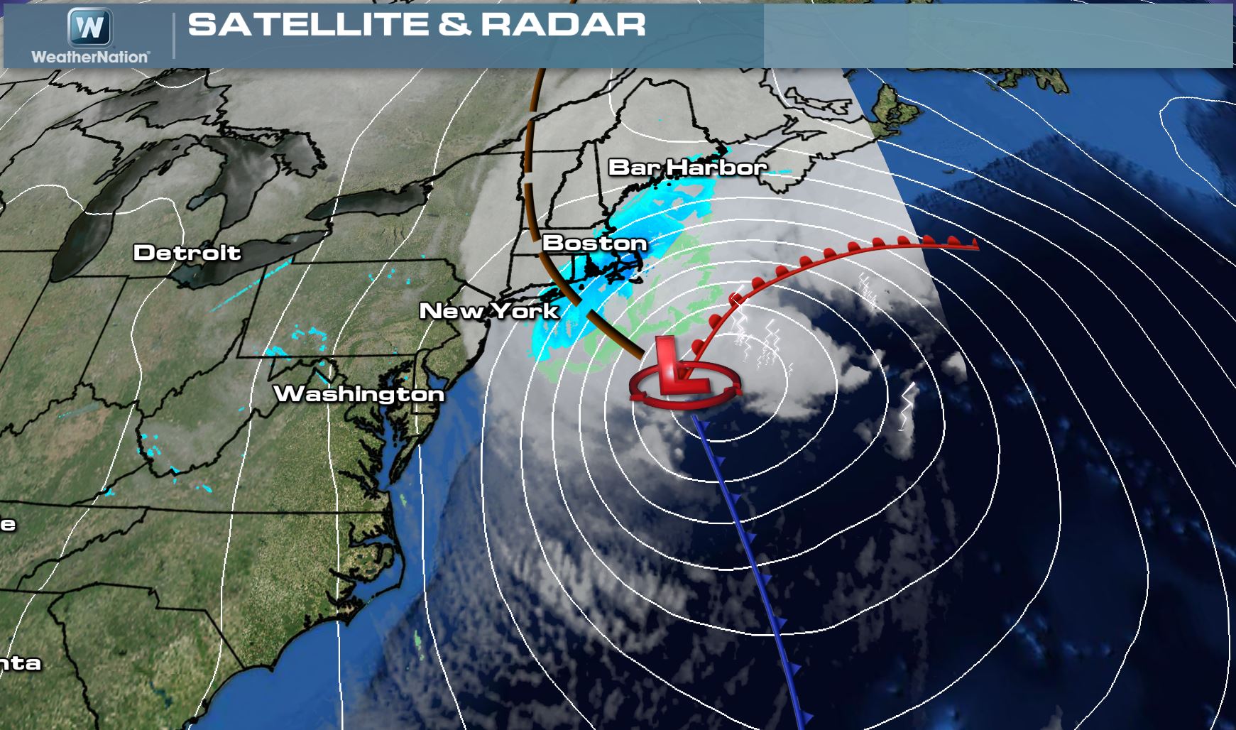
Massive Nor'Easter Clips Coast
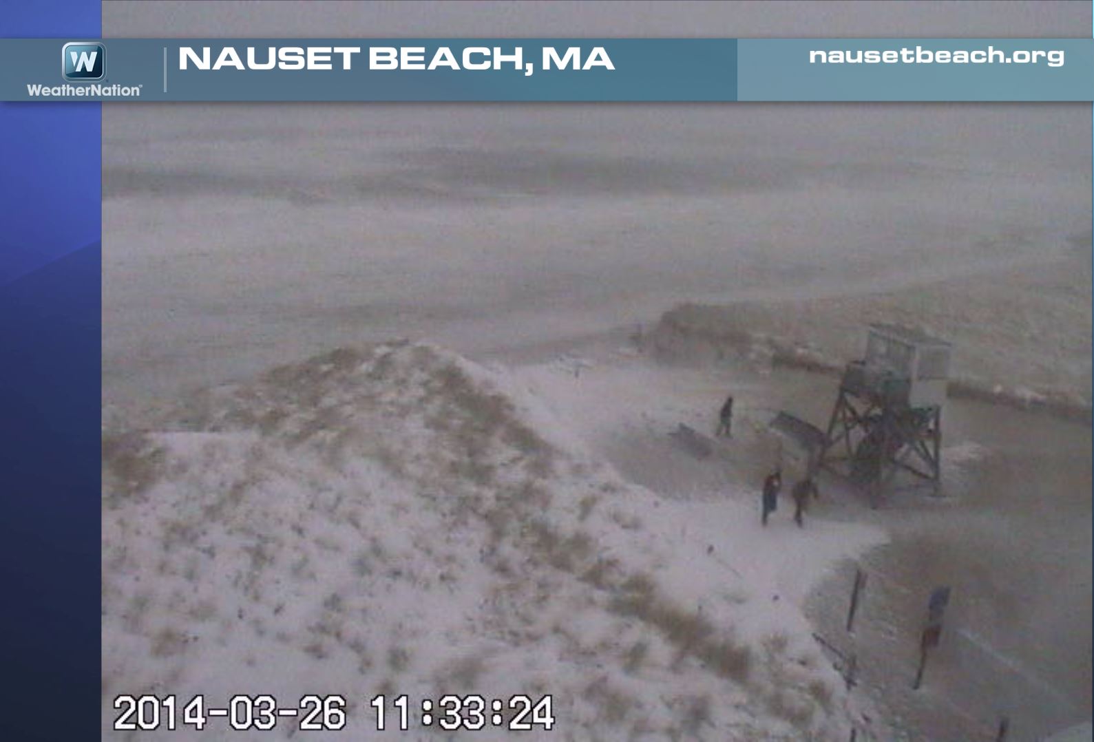
Take a look at the two different webcams from midday Wednesday. Note that Boston, MA looked fairly quiet (other than very strong winds), while places in the southeastern part of Massachusetts were getting slammed!
Southeast Massachusetts
Here's a closer view of the southeastern part of Massachusetts around midday Wednesday, when near hurricane force wind gusts and horizontal winds were blasting through!
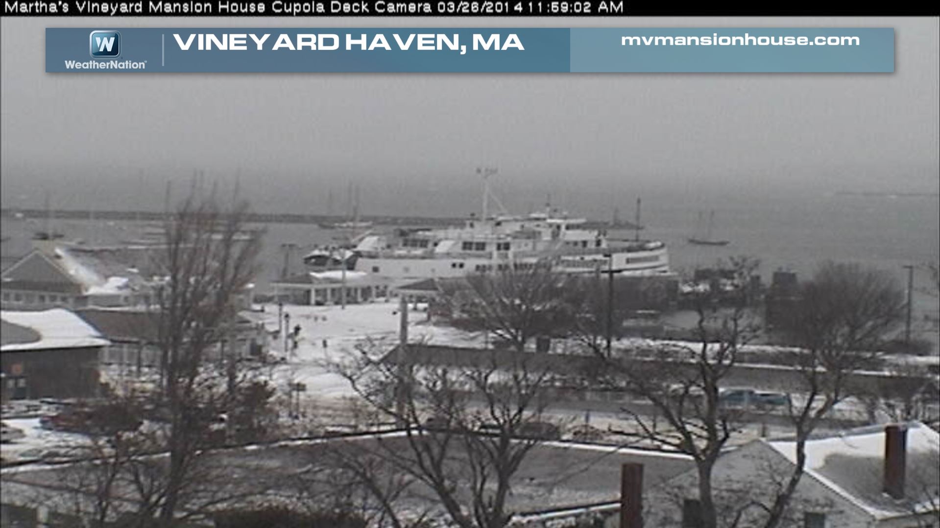
Martha's Vineyard
It's hard to grasp how crazy the weather was from these particular webcams, but the wind was strong enough to knock power out to several thousand customers during the storm!
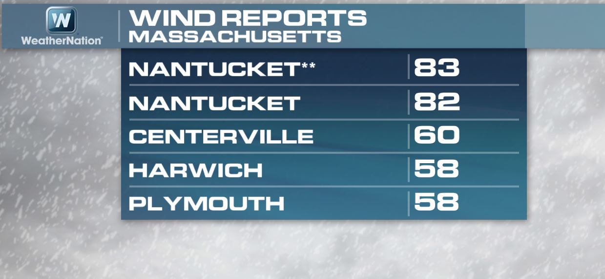
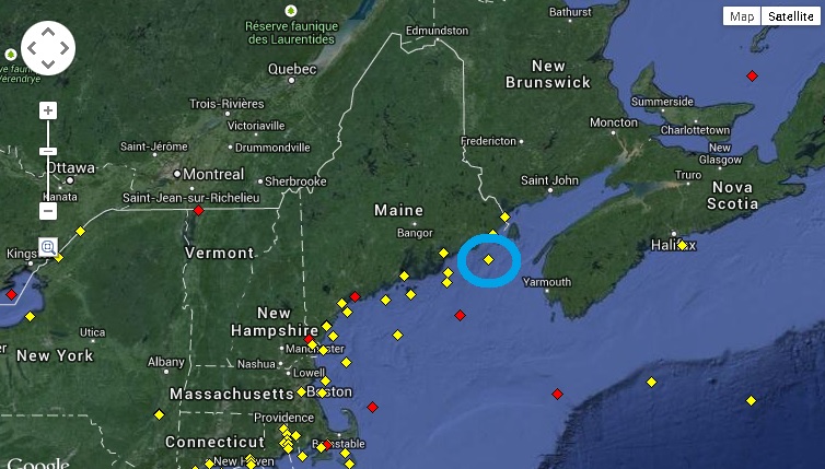
Strongest Wind Gusts
Here were some of the strongest wind gusts that had been observed from midday Wednesday in Massachusetts, mainly along the coastal communities.
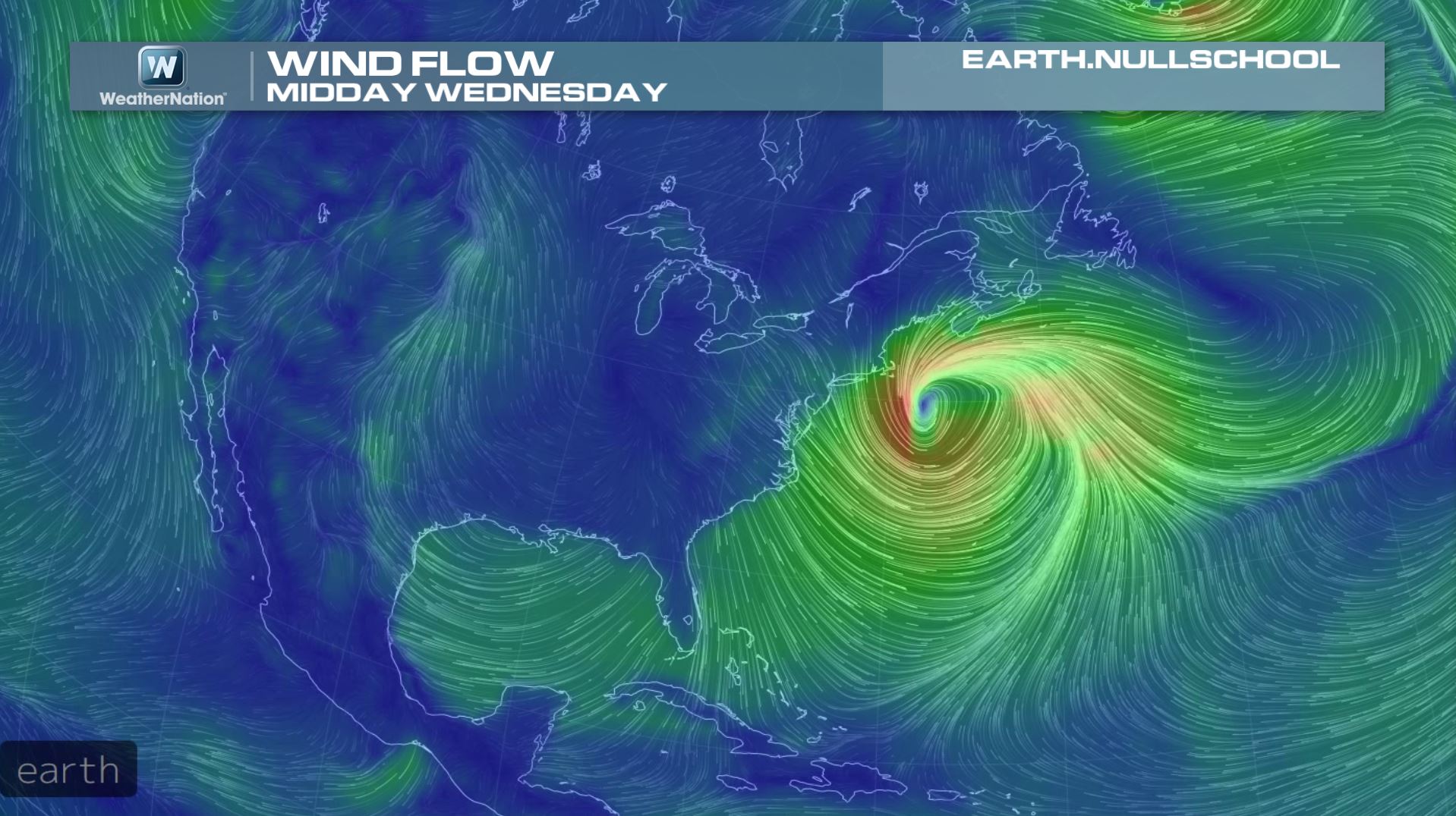
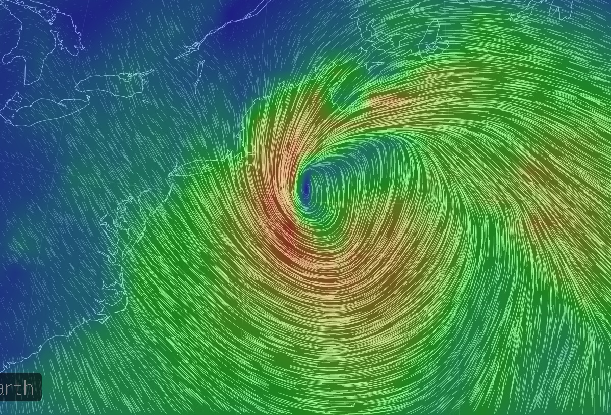
100mph+ Wind Gust?
Take a look at the buoy data here from just south of coastal Maine. First note the green line (pressure tendency) and look at how fast the pressure dropped from Tuesday evening to midday Wednesday! The red line indicates wind gusts (in knots), which was recorded to be near ~95knots midday Wednesday. Conservatively, 90knots converts to 103mph!
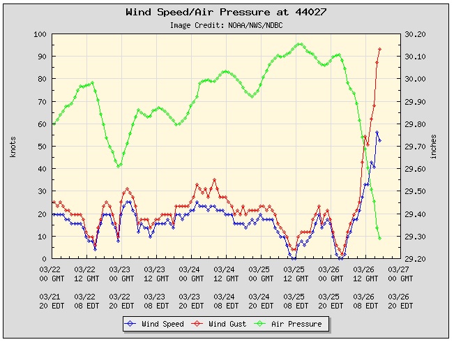
Buoy Location
This is the buoy that recorded the 103mph wind gust midday Wednesday as the center of the massive storm raced north.
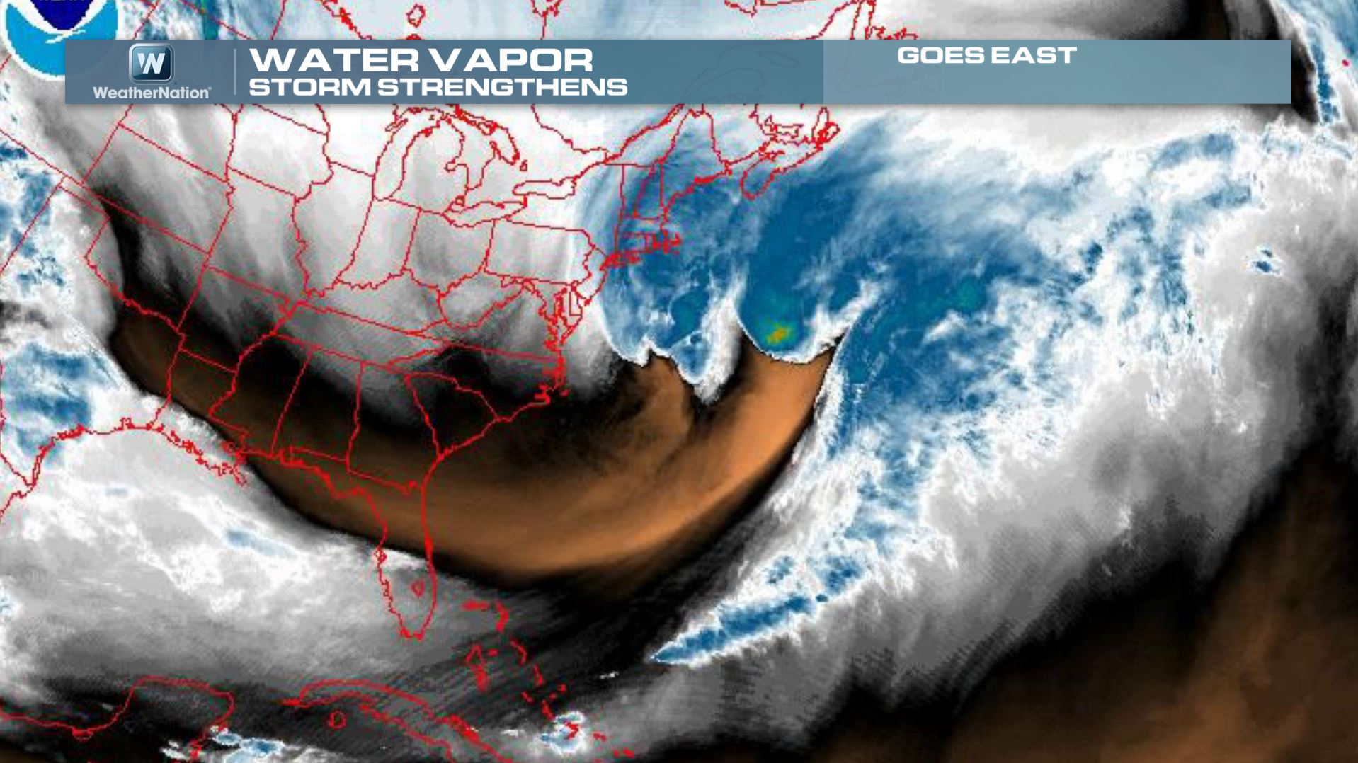
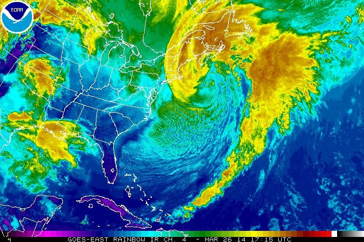
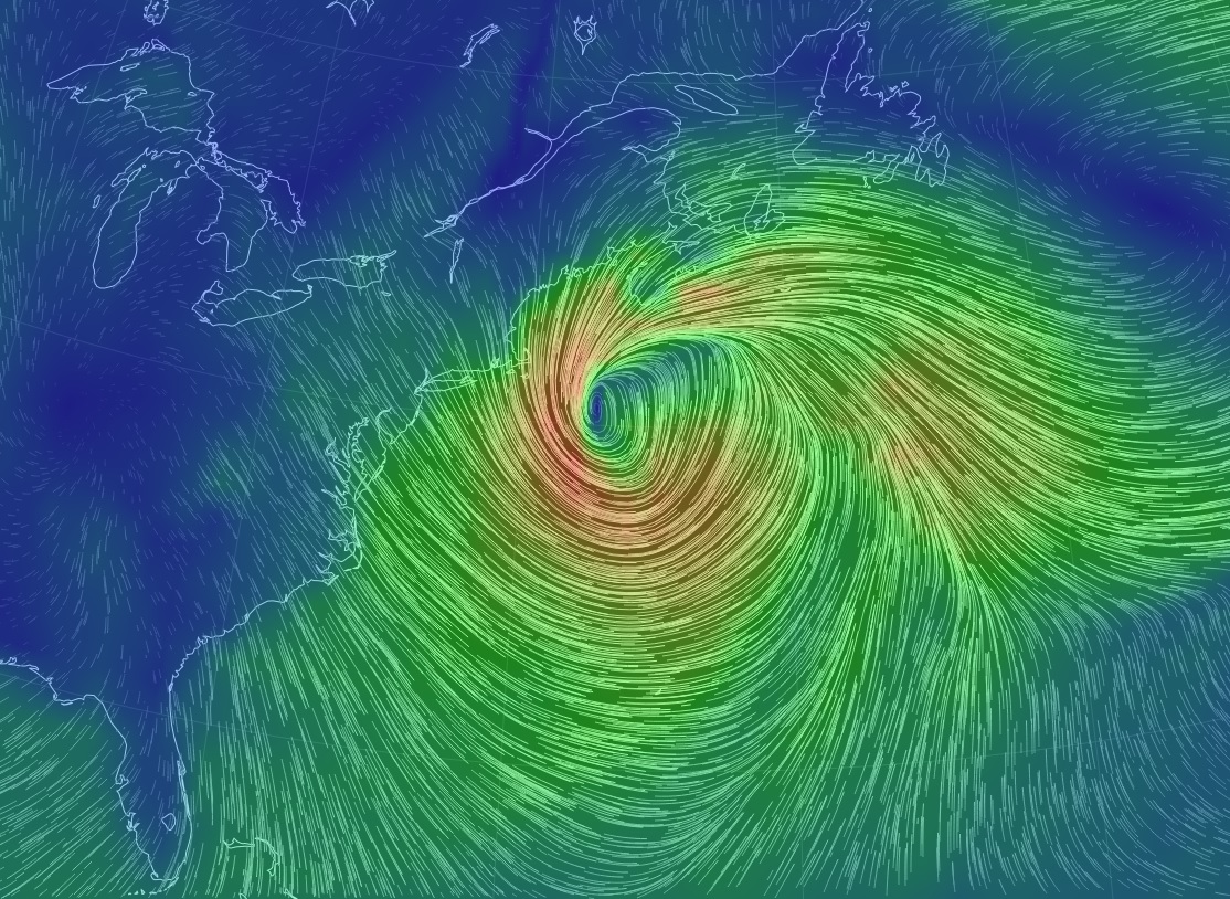
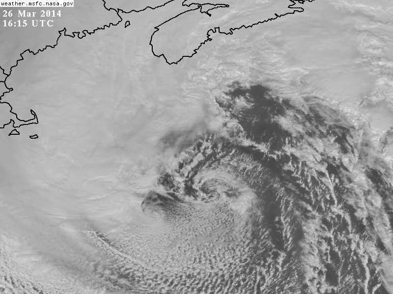
Meteorological Specimen
Take a look at some of the images I captured from various sources during the day Wednesday of the massive storm. From satellites to radar to wind flow, the more I looked, the more I was amazed... enjoy!
Water Vapor
IR Satellite
Wind Flow Midday Wednesday
Satellite & Radar Midday Wednesday
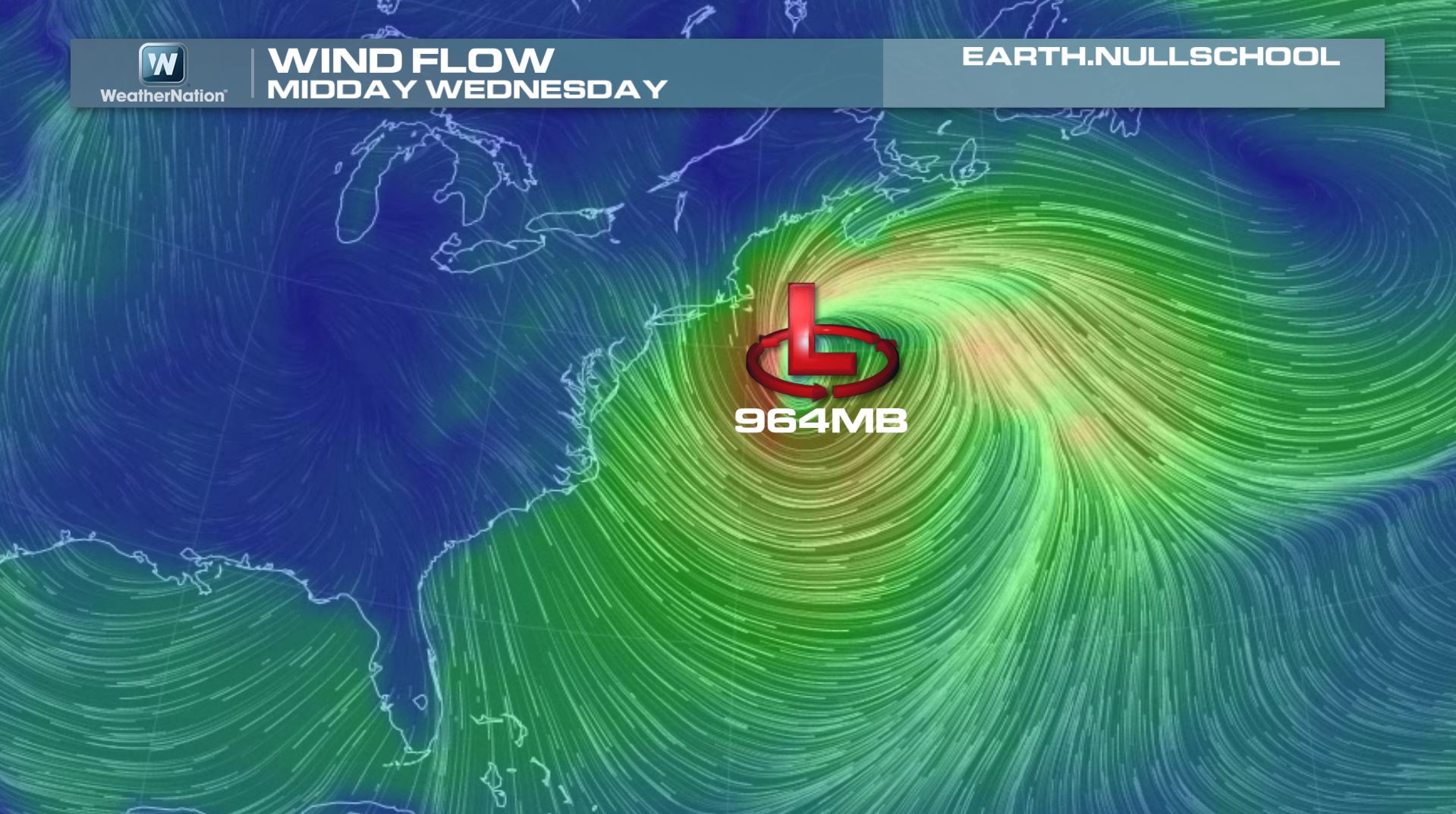
Wind Flow Midday Wednesday
At this point in the day, the central pressure was estimated to be around 964mb, which had dropped from near 1009mb 24hours previous to that report.
Visible Satellite of Storm Center Midday Wednesday
Wind Flow Midday Wednesday
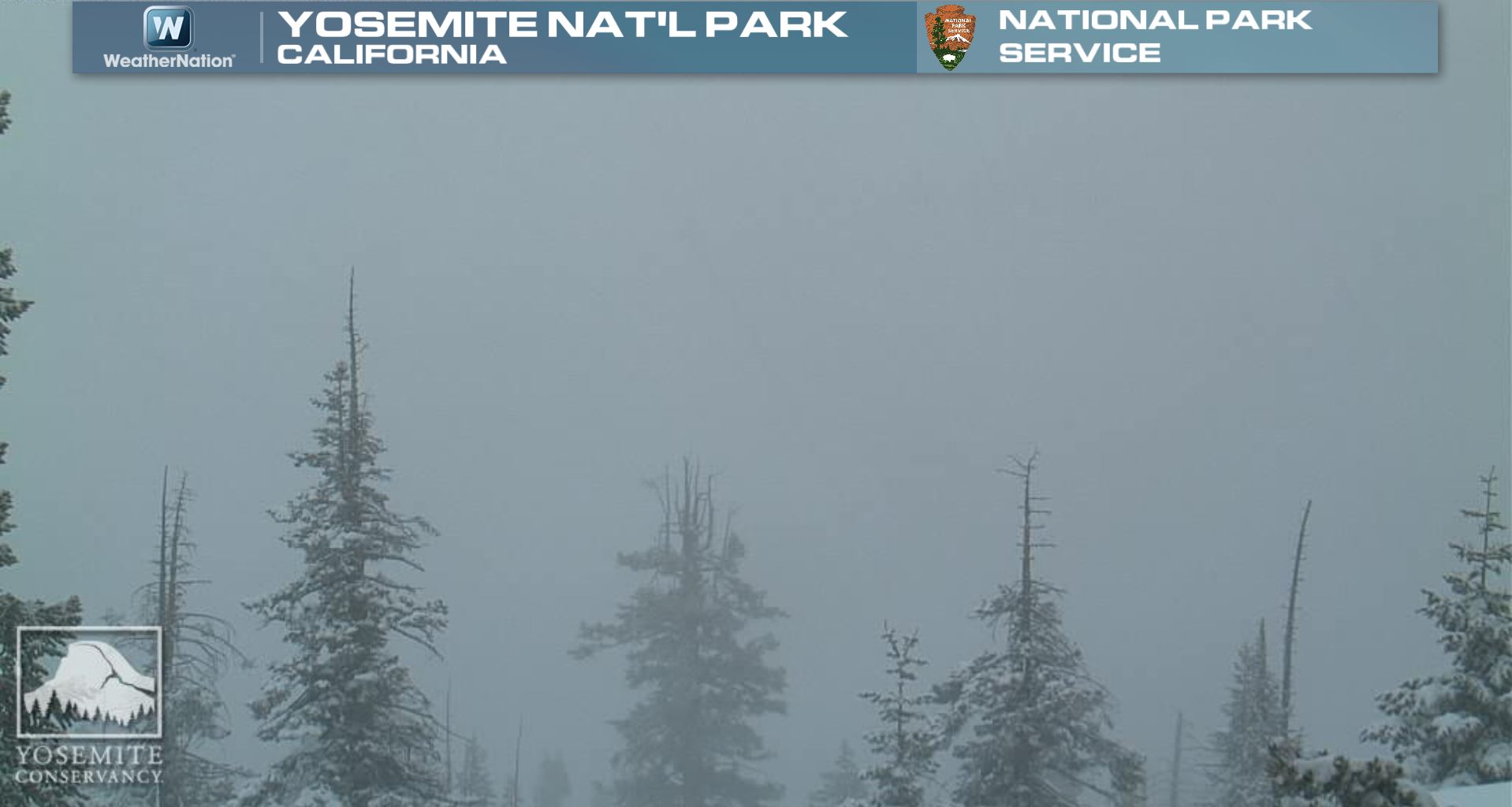
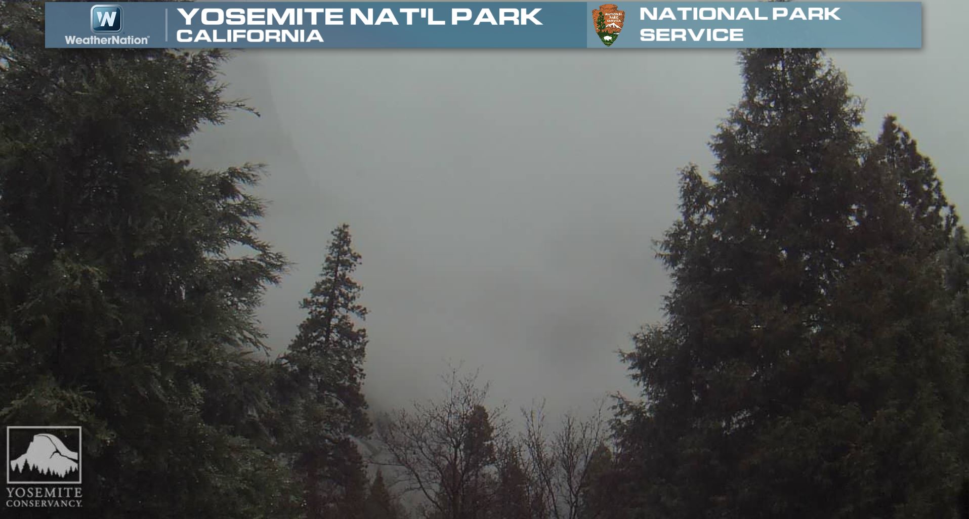
Western Snow
This is a nice sight! The webcam from Yosemite National Park on Wednesday showed reduced visibility from snow!
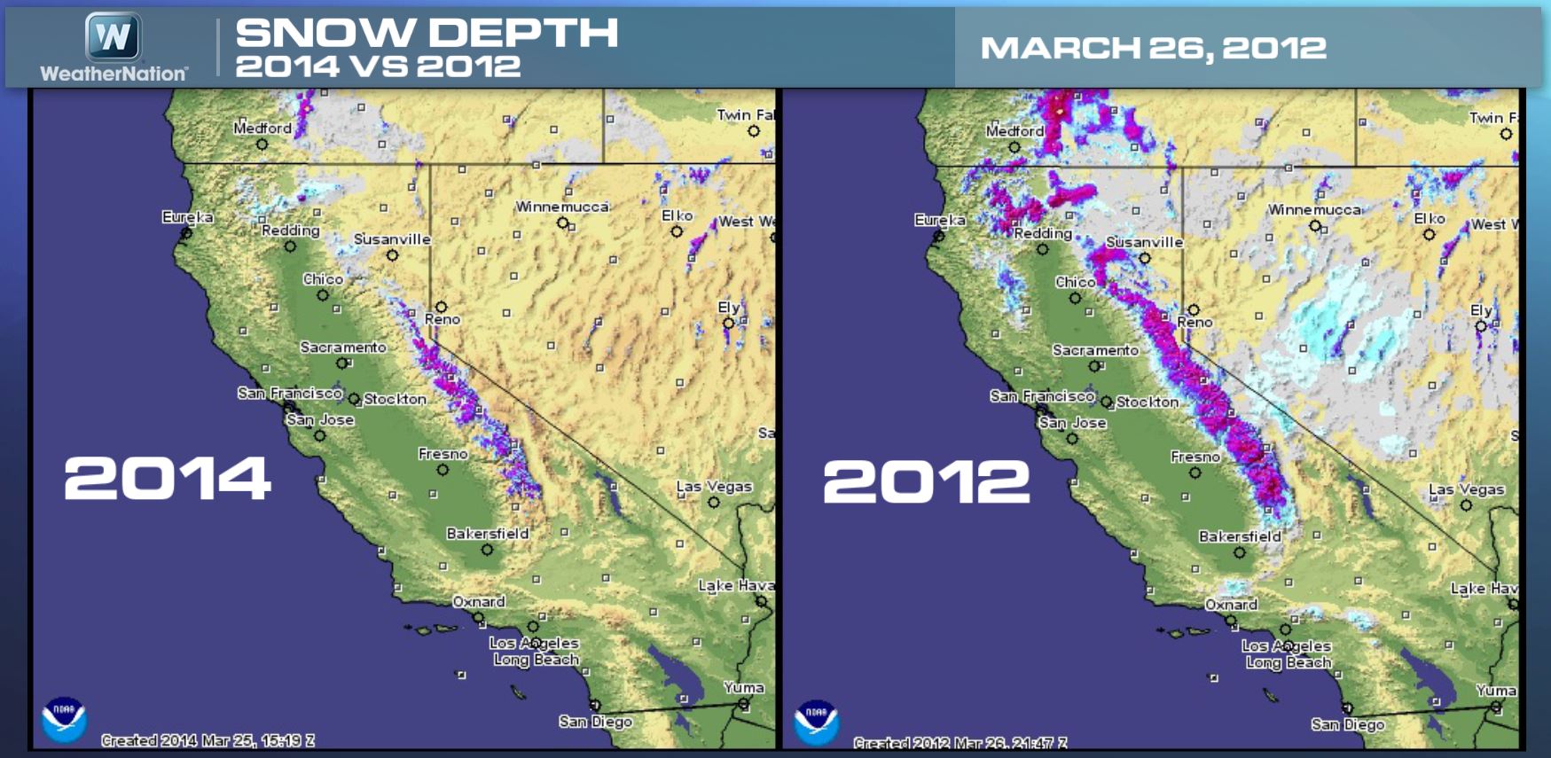
Sierra Snow Pack
I though this was interesting. This is the modeled snow coverage on March 26th, 2014 vs March 26th, 2012. Note how much more snow coverage there was two years ago at this time!
Additional Snow on the Way
The good news is that additional snow is on the way for the high elevations in the western part of the country. Snow amount could top out at 1ft. to 2ft. in parts of the Sierra Nevada range by midday Tuesday! Snow in the Colorado Rockies could approach 1ft. to 2ft as well by the end of the week.
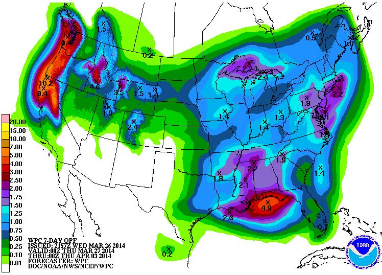
Precipitation Next 7 Days
According to NOAA HPC 7 day precipitation, some of the heaviest moisture looks to fall across the western part of the country. Sure it's good news for areas dealing with drought, but recent heavy moisture is part of the reason for that devastating mudslide near Oso, Washington. Additional heavy precipitation in these areas may not be great news.
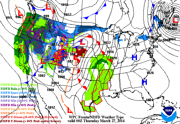
Storm System Moves East
A piece of energy from the Pacific will eventually find itself in the middle part of the country by late week. This storm will be responsible for widespread moisture from the Mississippi River Valley on east. Snow will be found across the international border, while strong to severe storms may be found a little farther south.
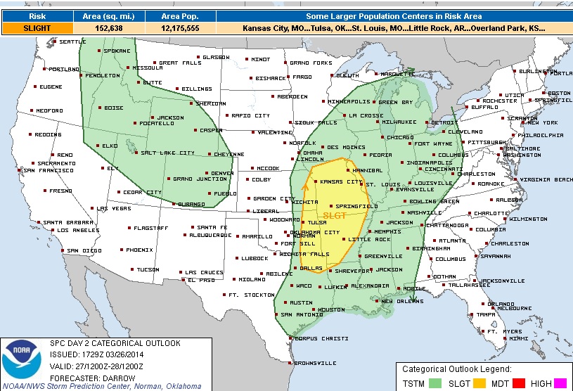
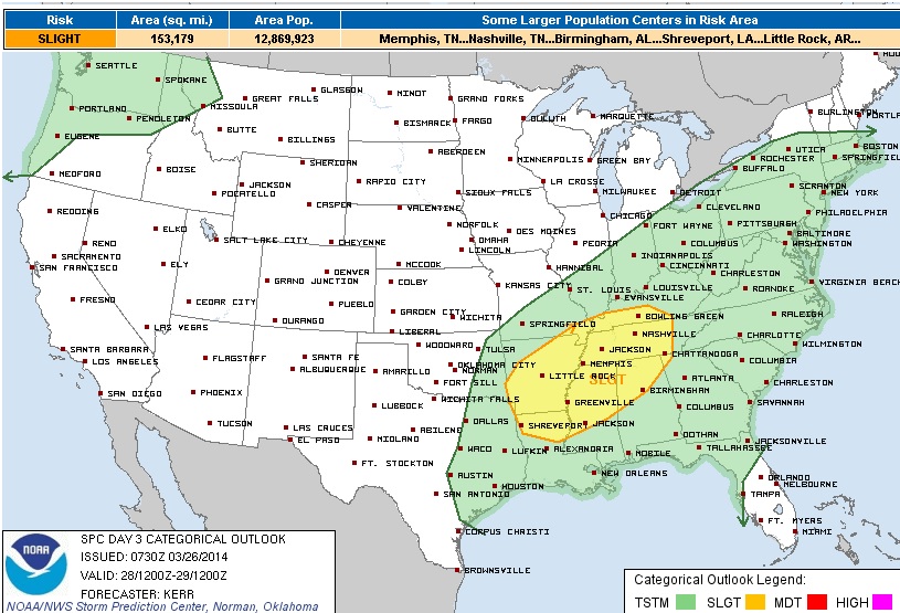
Severe Thunderstorm Threats Ahead
Thursday's Outlook from the SPC
"STRONG DEEP LAYER SHEAR FAVORS SUPERCELL DEVELOPMENT. SUPERCELLS THAT DEVELOP SWD TOWARD THE ARKLATEX WILL FORM WITHIN A MORE MOIST ENVIRONMENT WHERE SFC DEW POINTS MAY RISE INTO THE LOWER 60S. WHILE MUCAPE MAY NOT EXCEED 1500 J/KG AHEAD OF THE DRY LINE FORECAST SOUNDINGS WOULD SEEM TO SUPPORT THE POSSIBILITY OF VERY LARGE HAIL AND POSSIBLY TORNADOES...ESPECIALLY WITH DISCRETE ACTIVITY FROM SWRN MO SWD TO THE RED RIVER. HAVE INCREASED THE PROBABILITY OF SIG SEVERE ALONG THE DRY LINE TO INCLUDE THIS ENHANCED RISK. SEVERE THREAT WILL LESSEN DURING THE OVERNIGHT HOURS AS CONVECTION SPREADS INTO MORE STABLE ENVIRONMENT NEAR THE MS RIVER."
Friday's Outlook from the SPC
LARGE HAIL SHOULD BE THE PRIMARY SEVERE THREAT INITIALLY...BUT UPSCALE GROWTH INTO A FORWARD PROPAGATING MESOSCALE CONVECTIVE SYSTEM SEEMS A DISTINCT POSSIBILITY AS ACTIVITY SPREADS EASTWARD TOWARD THE TENNESSEE VALLEY FRIDAY NIGHT. THIS MAY BE AIDED BY A 40-50+ KT LOWER/MID TROPOSPHERIC SPEED MAXIMUM...WHICH WILL CONTRIBUTE TO THE RISK FOR SEVERE WIND GUSTS.
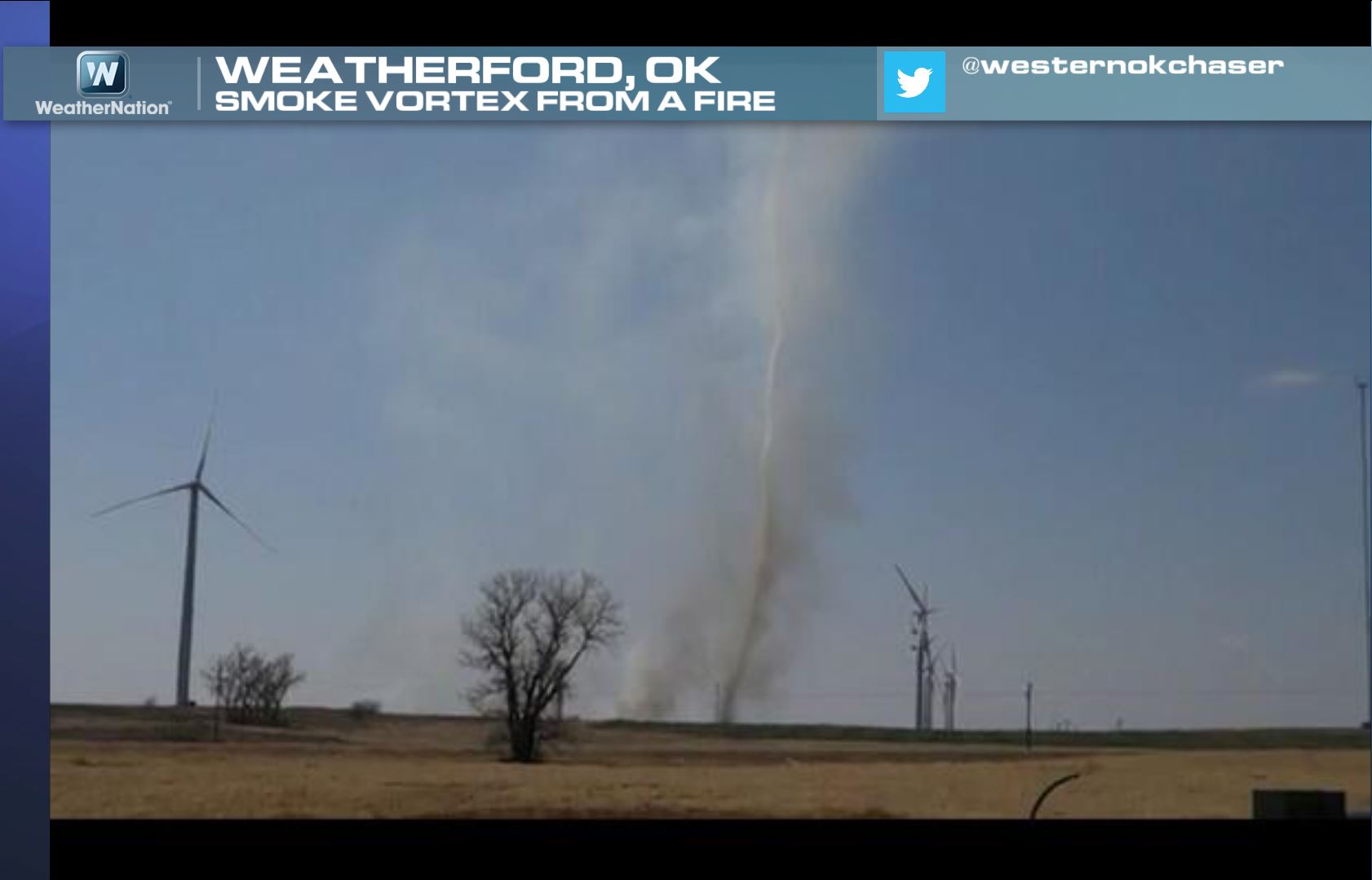
Smoke Vortex
Can't say I've ever seen one of these before. A grass fire along with gusty winds near Weatherford, OK led to this big smoke vortex. Thanks to @westernokchaser for the image!
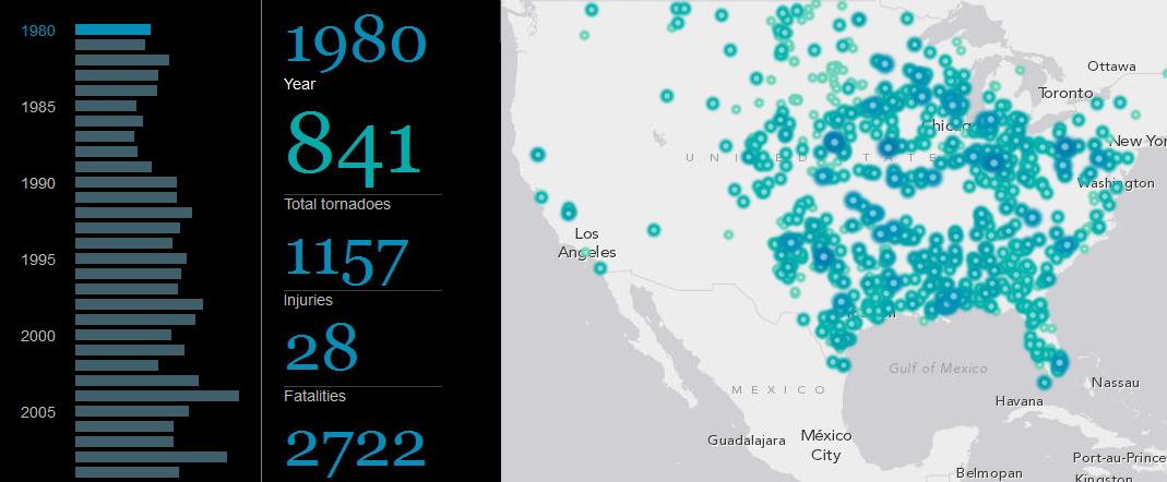
Massive Tornado Database
This is unreal! It's an interactive tornado database of every recorded tornado since 1980.
It was put together by Smithsonian.com, see more HERE:
Thanks for checking in and have a great rest of your week! Don't forget to follow me on Twitter @TNelsonWNTV

No comments:
Post a Comment