By Todd Nelson
Winter in Minnesota has a lot of great outdoor things to offer, but now that we're straddling seasons, it's been a little tough to get back outside and enjoy the weather. If you've been a little lazy over the last few weekends, don't feel bad... just blame Mother Nature
You won't have any excuses to get out and about this weekend as temperatures warm into the 40s and 50s across the southern half of the state. There's even a chance that some across the far southern part of the state could see 60s!
Get this, I had to go back to November 16th (50F) and November 17th (46F) to find the last 2, back-to-back weekend days that were in the 40s or warmer! That's more than 4 months since we've had temperatures over the weekend as warm as they'll be for the last weekend of March 2014!
Don't panic if you see jacket-less people either Saturday or Sunday. You might even see some brave souls in shorts or T-shirts. It could initially be shocking, but just know that more normal winter wear will likely resume next week as a rain/snow mix arrives Monday.
Enjoy the next 48 hours! Hopefully the fleeting spring weather will come back soon!
=====================
FRIDAY NIGHT: More clouds, mostly quiet. Low: 20. Winds: Light ESE.
SATURDAY: A bit breezy with bright sun. High: 44. Winds: SSE 10-20.
SATURDAY NIGHT: Partly cloudy and quiet. Low: 35. Winds: S 10-15.
SUNDAY: Spring fever! Fading sunshine by the afternoon with rain developing overnight. High: 57. Winds: Turning NNE 10-15 late.
MONDAY: Breezy. Rain changes to slushy snow accumulations. Wake-up: 38. High: 45 early & falling.
TUESDAY: April Fools' Day. Clearing and cooler. Wake-up: 23. High: 36.
WEDNESDAY: Watching storm to the south. Wake-up: 24. High: 39.
THURSDAY: Light rain/snow chance south. Wake-up: 26. High: 40.
FRIDAY: Bright sun, getting warmer. Wake-up: 29. High: 45.
======================
This Day in Weather History
March 29th
1986: Record warmth with July-like temperatures. The Twin Cities hits 83.
=====================
Sunrise/Sunset Times
March 29th
SUNRISE 659 AM
SUNSET 737 PM
====================
Moon Phase for March 29th at Midnight
0.5 Days Before New Moon

==================
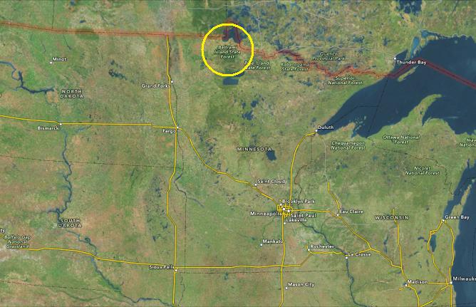
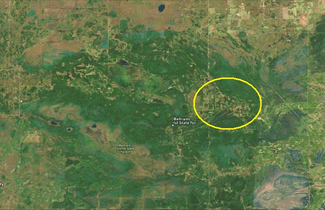
Minnesota Shaped Forest?
Alright, this takes the cake for one of the coolest things I've seen in a while! It's a Minnesota shaped forest, which you can view from a satellite mapping system. This is what the Minnesota shaped forest looks like in the Beltrami Island State Forest.
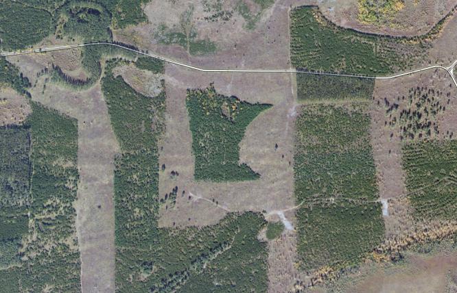
Here's how you can find it! Good luck!
Weekend Outlook
Ahh, now this is more like it! Finally a 'warmer' weekend across the Upper Midwest. Temperatures will be warmer on Saturday than they were on Friday, but Temperatures on Sunday could be quite mild considering how cold it's been for so long. Enjoy!!

Minneapolis Temperature Trend
The weekend ahead looks very pleasant (temperature-wise). Note the Sunday high approaching 60F in Minneapolis! This will be the first time since November 16th (50F) and November 17th (46F), when high temperatures for a Saturday/Sunday were in the 40s or warmer. By the way, if we hit 60F on Sunday, it'll be the first 60F high temperature since October 13th, when the mercury topped out at 61F!

Minneapolis Snow Cover
Surprise, Surprise. Would you have guessed that this winter season made it into the top 10 for longest stretch with at least 1" of snow on the ground at the MSP Airport?
"At 7 AM CDT on Thursday morning the snow depth reading at the Minneapolis Int. Airport was a trace (it was 2 inches on Wednesday, March 26th at this same time). The string of consecutive days of snow depth of 1 inch or greater that began on December 4, 2013 - March 26, 2014 totaled 113 days. This places Minneapolis in 10th place for the longest amount of consecutive days in this category."

Liquid Water Discovered on Surface of Minnesota!
HAHAHAHAHAA!
"FORT LAUDERDALE—In a press conference held Tuesday morning, NASA officials have announced the discovery of liquid water on the surface of the region commonly referred to as Minnesota. The discovery has come as a surprise to the space exploration organization, which has listed the state of Minnesota as “unsuitable for any and all biotic life” since mid-November. Temperature trends extrapolated from four months of hard data had extensively confirmed the scientific community’s well-formed hypothesis that Minnesota temperatures were unlikely to shift above “subarctic status.”"
Read the full article HERE:

More Snow on the Way?
Look at the storm that is poised to move in early next week. It looks like another tightly wound system that will have rain changing to snow in spots. However, some longer range models suggest a decent swath of heavier snow on the northern and northwestern edge of the storm center.

Increasing Snow Chance
The developing storm system for early next week looks to drop some snow, but how much and where is not exactly known yet. The image below shows the probability of 2" or more through 7pm Monday is nearly 50% or more in the light blue swath from the Dakotas into northern Minnesota.
Probability of at Least 2" Snow

Probability of at Least 8" Snow
At this point, the probability of at least 8" of snow through 7pm Monday isn't quite as high, but things could change! Stay tuned for more!

=======================
Desert in Bloom!
Thanks to my good friend Rich Koivisto for this great picture from near Bullhead City, AZ. Looks like the desert is blooming!

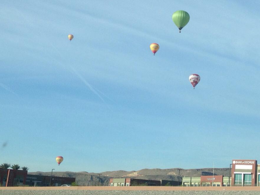
Nevada Balloons
Here's another neat picture from near Spring Valley, NV of hot air balloons. Thanks to my good friend Stephanie Trindade who spotted these on her way to work Friday.
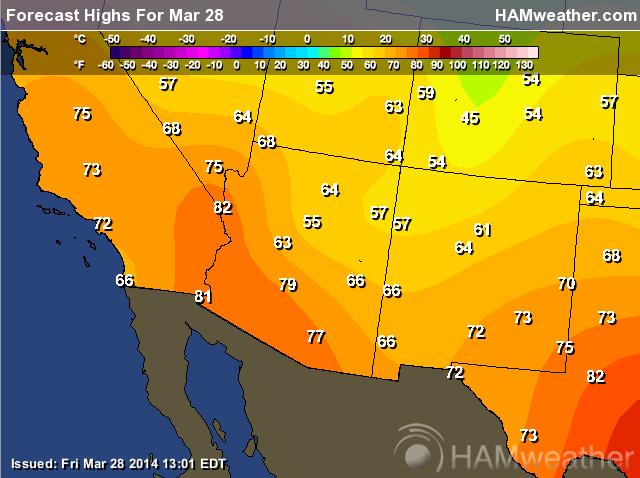
Highs Saturday
Temperatures in the Southwest certainly look appeasing this Saturday. Interestingly, temperatures in the Southwest are running pretty close to average.
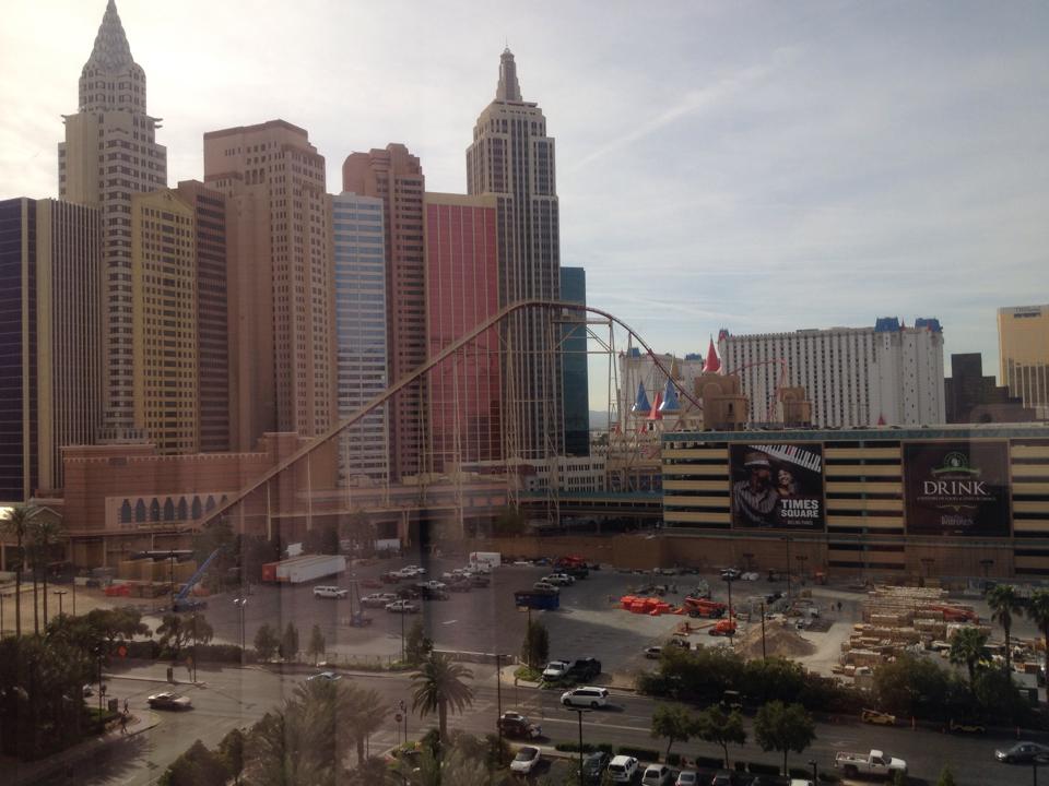
Vegas!
Thanks to my good friend Jason Larson for this picture, who is enjoying some time in Vegas.
Back From the Iditarod
My good friend, Monica Zappa, just recently finished the Iditarod with a time of a little more than 13 days and 6 hours! First of all, CONGRATULATIONS and glad to see that one of your sick puppies is on the mend and doing well!
Here's a great story about Monica as she was preparing for the race. See the story from the local ABC station out of Anchorage HERE:

Friday Storms
Take a look at this Texas-sized hail out of Coperas Cove, TX. @timbofowler snapped a picture of this golf ball sized hail as thunderstorm passed by.

Alabama Rain
Heavy rain on Friday led to this at a golf course in Sylacauga, AL. Thanks to @FarmlinksGC for the picture below.

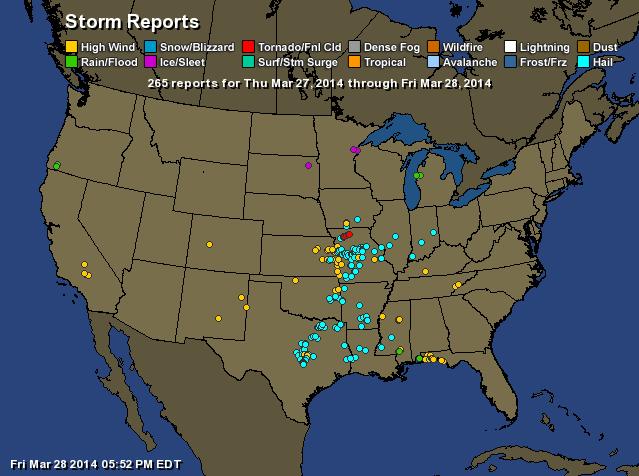
Stormy Weather
As of 5:53pm EDT Friday, this was the storm report map from Thursday and Friday.
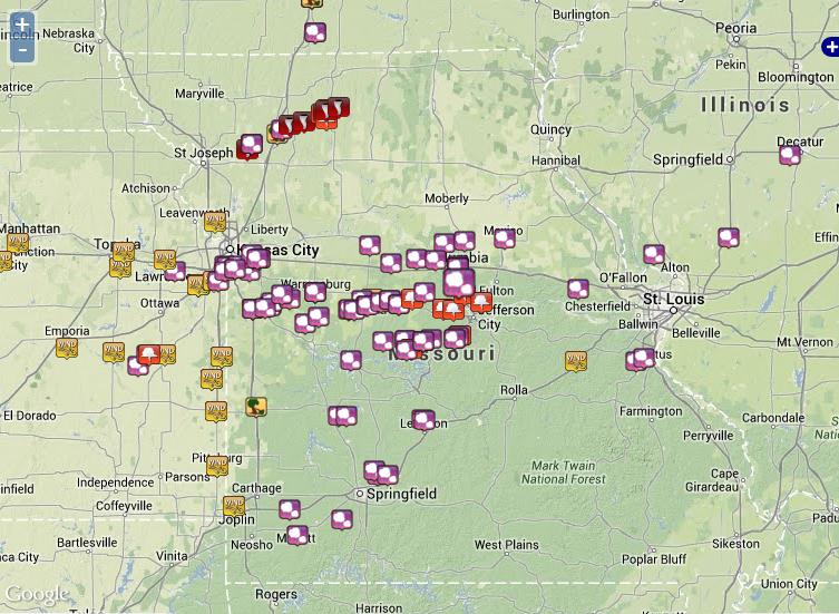
Missouri Tornadoes
Here's a closer view of the storm reports from Thursday in Missouri. There was also a tornado report from Iowa as well.
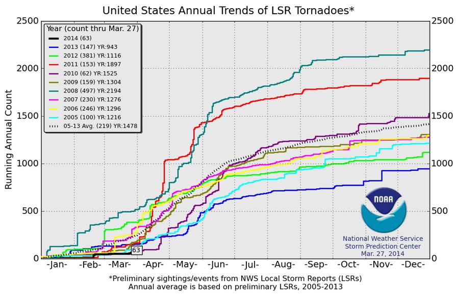
2014 Tornado Count
As of March 27th, the PRELIMINARY tornado count across the nation was 63, which is significantly lower than the short term (2005-2013) average of 219 through that date. Note that since 2005, we've never seem this few of tornado reports through this date.
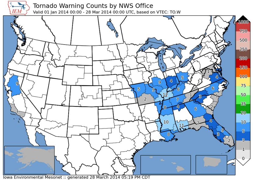
Tornado Warning Counts so far in 2014
This is an interesting graphic of how many tornado warnings have been issues by various weather forecast offices across the country. Note how few of these warnings have been issued so far through March 28th.
(Image courtesy: Iowa State University)
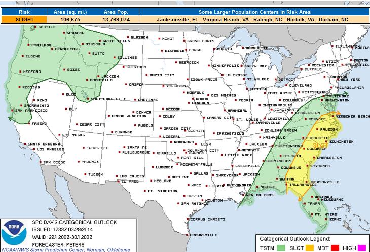
Saturday Severe Threat
Unfortunately, the multi-day severe weather threat is not over just yet. What started on Thursday, looks to continue through Saturday across the southeastern part of the nation.
Here's the latest thinking from the SPC:
"SOME POTENTIAL REMAINS FOR SLIGHTLY GREATER DESTABILIZATION WITHIN A NARROW CORRIDOR IN THE WAKE OF WARM CONVEYOR BELT CONVECTIVE BANDS AND AHEAD OF THE COLD FRONT. IF THIS OCCURS...THEN STRONGER HEIGHT FALLS SPREADING INTO THIS REGION WITH THE AMPLIFYING TROUGH SUGGEST THE POTENTIAL FOR A GREATER SEVERE WEATHER THREAT AS STORMS DEVELOP ALONG THE COLD FRONT FROM THE CAROLINAS INTO ERN GA...AND POSSIBLY SRN VA. FAVORABLE DEEP LAYER SHEAR WOULD SUPPORT STORM ORGANIZATION WITH DAMAGING WINDS THE PRIMARY THREAT. HOWEVER...VERTICALLY-VEERING LOW-MID LEVEL WINDS SUGGEST A TORNADO THREAT CANNOT BE RULED OUT."
See more from the Storm Prediction Center HERE:
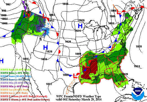
Active Weather Continues
The storm system responsible for our latest severe weather reports in the middle part of the country will begin to lift north to the Northeast with additional heavy rain and winter weather potential. Meanwhile, another storm system developing in the Pacific Northwest begins to shift east towards the Midwest by the end of the weekend/early next week. Heavy rain/thunder can't be ruled out again in the middle part of the country, while heavy snow looks possible on the northern flank of the storm from the Dakotas to northern Minnesota. Stay tuned for further developments on this...
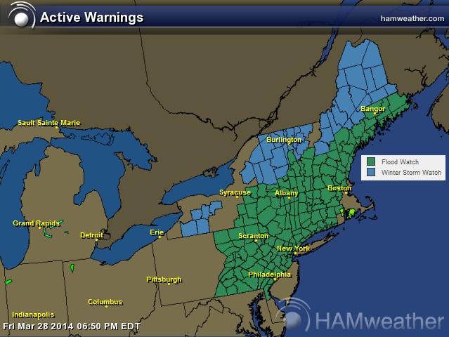
Northeast Weather Concerns
As this storm begins to move north, heavy precipitation will be cause for some concern through the end of the weekend. At this point flooding and heavy snow could be problematic for some.
Flood watches have been posted where 1" to 3" of rain and ice jams may be possible.
Winter Storm Watches have been issued where as much as 6" to 12" of snow can't be ruled out.
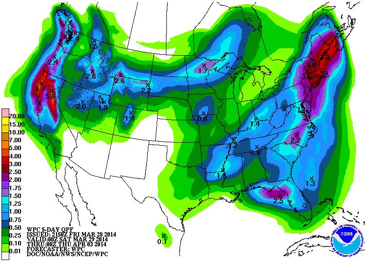
Precipitation Outlook
According to NOAA's HPC, the 5 day precipitation forecast suggests another heavy surge of moisture in the Northeast along with continued heavy moisture in the western part of the country. A piece of energy from the Pacific will transition into the central part of the country with another decent shot of heavier snow across the northern tier of the nation.
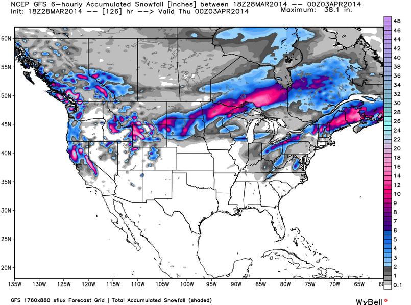
Snowfall Potential
Here's the U.S. snowfall potential through midweek next week. Note the heavier blobs of snow that could potentially pop up across the higher elevations in the West along with a pretty significant chance across the Upper Midwest and in parts of the Northeast. Unfortunately, wintry weather doesn't appear to be over just yet!
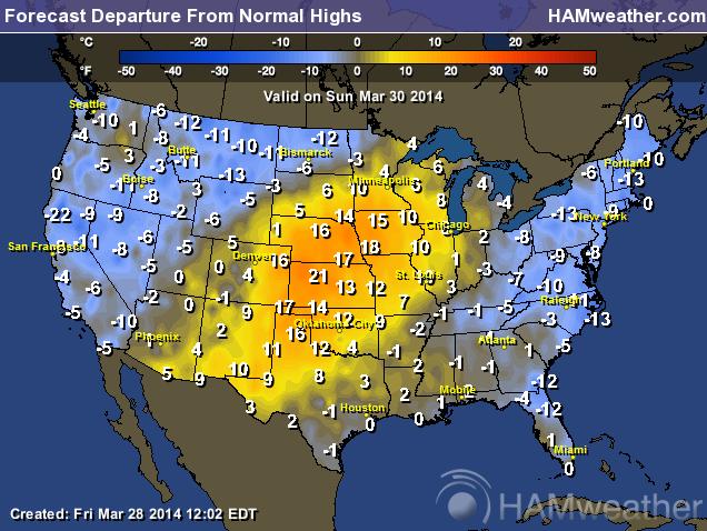
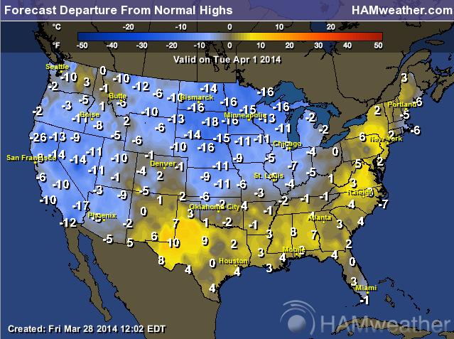
Temperature Outlook
The temperature outlook looks to take a bit of a roller coaster ride. Highs on Sunday look to be significantly warmer than average, but by Tuesday, we'll be much colder than average again!
Sunday
Tuesday
Thanks for checking in and have a great weekend ahead! Don't forget to follow me on Twitter @TNelsonWNTV

Great post . It takes me almost half an hour to read the whole post. Definitely this one of the informative and useful post to me. Thanks for the share.Miami Moving CompanyForward Van Lines is a family owned moving company providing local, residential, commercial, industrial moving service in Ft Lauderdale & Miami, FL and the surrounding areas.
ReplyDelete