By Todd Nelson
I don't know about you, but my basketball bracket was busted in the firsts couple of days of the tournament. The team that I picked to take the championship was out by Friday. There have been several upsets this year, but I guess that's why they call it "March Madness".
The madness of our March has been the much colder than normal weather that we've had to endure. Average temperatures have been running nearly 7F below average and it appears we won't get a break from the chilly weather until maybe the last few days of the month. More on that in a bit.
We're in a bit of an active pattern with light snow chances Monday and again later this week. The system that blows through on Thursday could be a little more interesting. At this point, a rain/snow mix could glance the southeastern part of the state... stay tuned.
Jacket worthy weather will be with us through the week ahead, but extended weather models suggest temperatures warming into the 40s and possibly even the 50s by next weekend! I don't want to put too much faith into the models just yet. The way this March is going, I wouldn't be surprised if we stay below avg. until next week. Don't jinx it!
=======================
SUNDAY NIGHT: Clouds thicken late. Chance of light snow by daybreak Monday. Low: 12. Winds: WNW 5-10
MONDAY: Chance of light snow. Light snow accumulations possible across extreme southern MN. High: 32. Winds: SSW 5-10.
MONDAY NIGHT: Still mostly cloudy with a few lingering flurries. Low: 8. Winds: NW 10.
TUESDAY: Gradual clearing. Brisk winds with more PM sun. High: 20.
WEDNESDAY: Clouds thicken, light mix late in northern MN? Wake-up: 10. High: 37.
THURSDAY: Growing threat of rain/snow. Wake-up: 29. High: 39.
FRIDAY: Partly sunny, a few PM flakes. Wake-up: 20. High: 35.
SATURDAY: Now we're talking. Near average temps! Wake-up: 22. High: 44.
SUNDAY: Highs in the 50s? Don't jinx it! Wake-up: 31. High: 53.
=======================
This Day in Weather History
March 24th
1851: Heat wave across Minnesota with 60's and 70's common.
======================
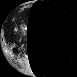
Moon Phase March 24th
=====================
Cold Sunday Morning in Northern Minnesota
LOCATION TEMP
CRANE LAKE -26
INTERNATIONAL FALLS -26
EMBARRASS -25
EFFIE -24
BRIMSON -23
BIGFORK -23
KABETOGAMA GENERAL STORE -23
SOUTH FORK KAWISHIWI RIVER -23
ORR -20
COTTON -20
BIGFORK -20
=====================
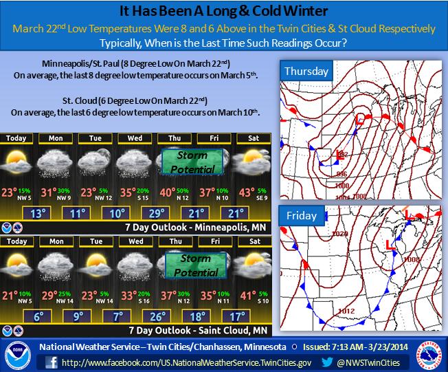
Minneapolis Outlook via the National Weather Service
"Based on the overnight lows from March 22nd, Minneapolis/St. Paul has had 118 days of 8 degrees or lower this season, and St. Cloud has had 129 days of 6 degrees or lower this season. Light snow will be possible along the Iowa/Minnesota border Monday morning. A stronger storm system may affect the Upper Midwest Thursday and Friday. We could see 50s by next Sunday."
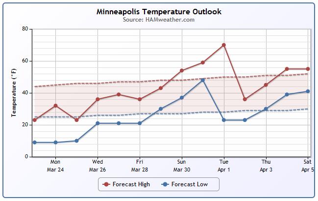
Minneapolis Temp Trend
It'll be an uphill climb through much of the week. The temperature trend through the early part of April looks somewhat promising with highs in the 40s and 50s. This particular model is suggesting temperatures in the 60s even by early next week... stay tuned for more!
Weather Outlook
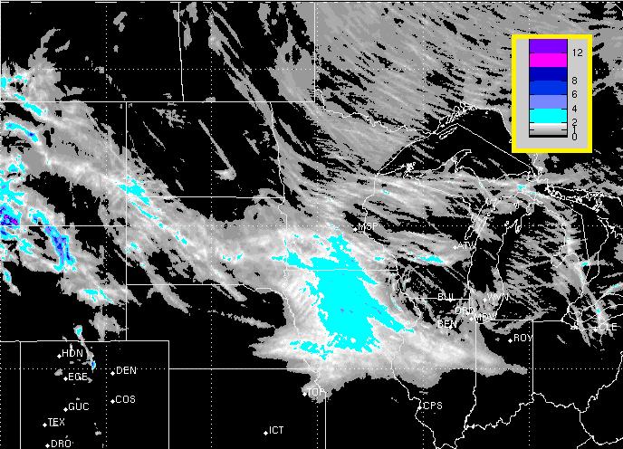
Our snow chance for Monday looks less impressive than it did earlier this weekend. Note that central and southern MN get only a glancing blow from the fast moving clipper system.
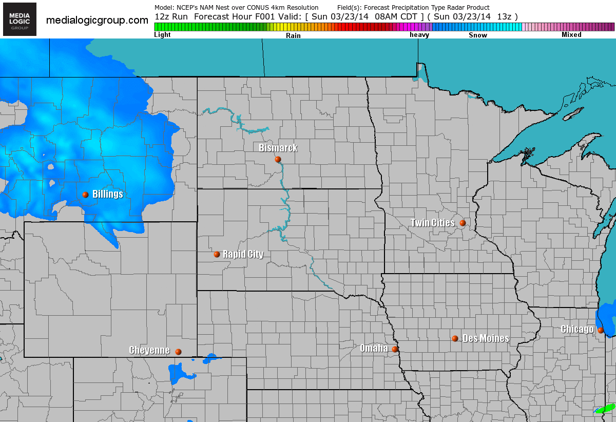
Snow Potential
A fast moving clipper system will quickly move through the Midwest dump a quick coating of snow. The best chance of light accumulations will be from extreme southern MN to Iowa.
Weather Outlook
The clipper over the Midwest on Monday will actually play a role in the large storm system that looks to develop off the New England Coast by Tuesday.
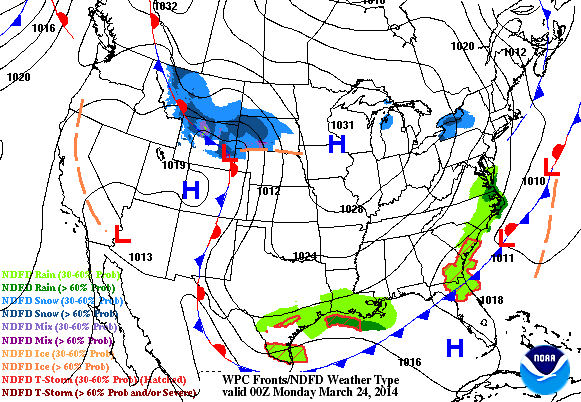
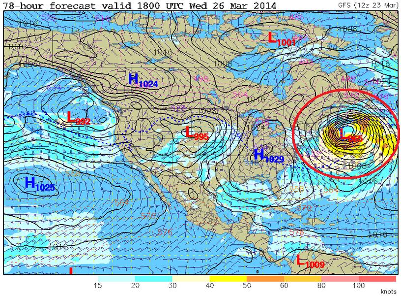
Northeast Storm System
Weather models continue to indicate a very strong wave off the New England Coast by Tuesday/Wednesday. The wind field surrounding this storm looks to be quite impressive, which will likely impact the Northeast.
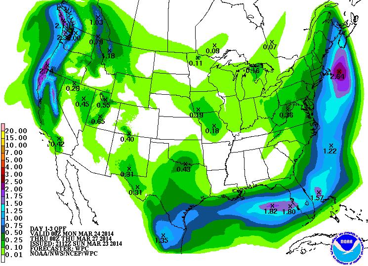
Precipitation Outlook
According to NOAA's HPC 3 day precipitation outlook, the swath of precipitation that stretches along the Eastern Seaboard will be associated with the developing storm system. It appears that the heaviest precipitation has shifted just a little farther east. However, places right along the coast could see some heavier snow. Stay tuned for more!
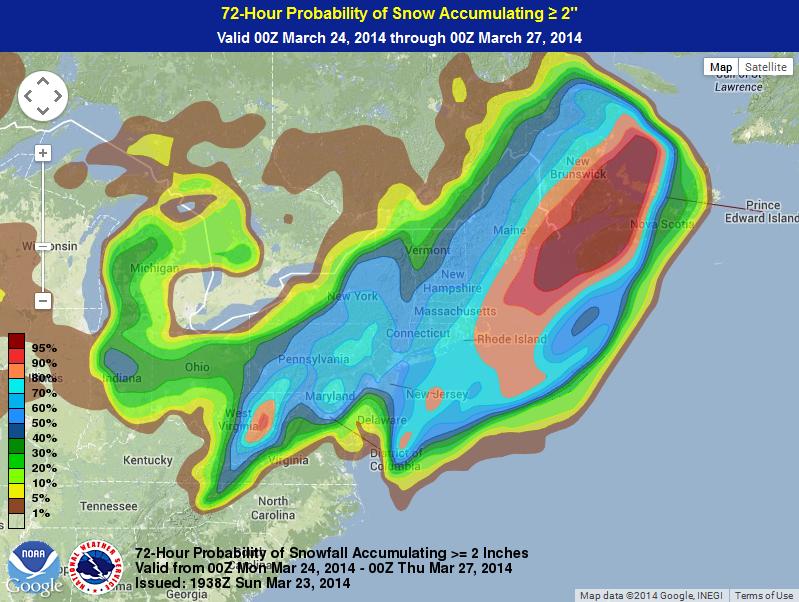
2" Snow Probability
According to NOAA's Weather Prediction Center, the probability of at least 2" of snow through PM Wednesday is the highest right along the coast
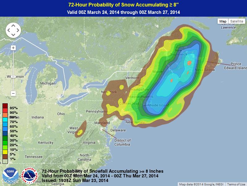
8" Snow Probability
Here's NOAA's WPC probability of at least 8" of snow or more through PM Wednesday is quite a bit less, but still shows the best potential right along the coast.
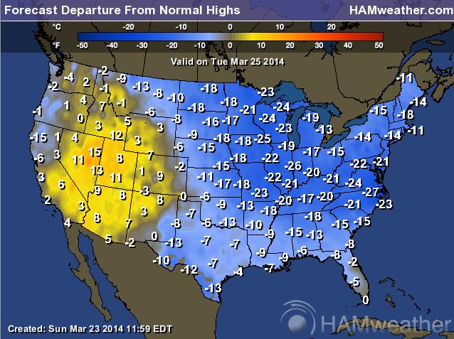
Continued Cold
Unfortunately, the much colder than average weather will continue across the eastern two-thirds of the country through much of the week. Here's the temperature departure from normal outlook for Tuesday, which shows a significant amount of cold air (for this time of the year) east of the Rockies.
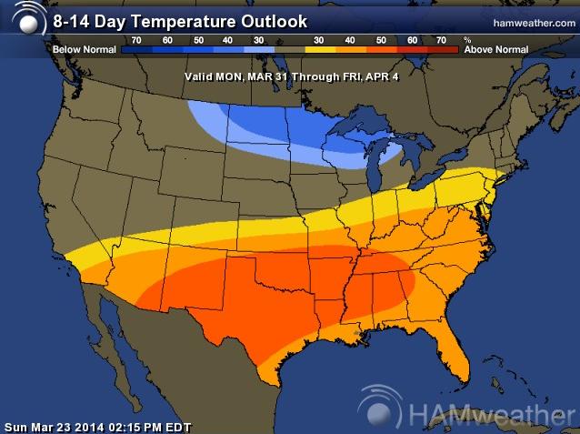
Extended Temperature Outlook
According to NOAA's CPC, the 8 to 14 day temperature outlook suggests much warmer temperatures moving in across the southern half of the nation, while the Upper Mississippi Valley looks to stay a little cooler than average
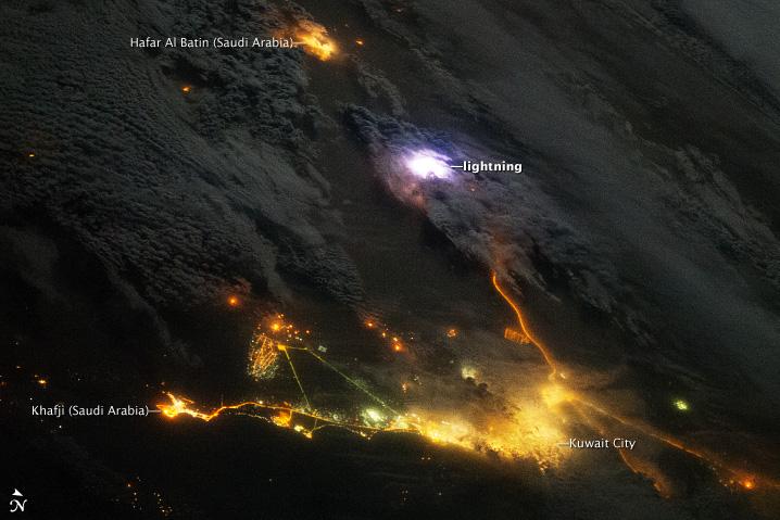
Sensing Lightning from the ISS
Here's a cool story from NASA's Earth Observatory, which talks about lightning being observed from space!
"Across the entire atmosphere of Earth, lightning flashes occur about 50 times per second. That’s 4.3 million times a day and 1.6 billion times a year. Using a new instrument on the International Space Station (ISS), scientists hope to capture and dissect at least a few of those flashes every day.
Installed on the ISS in August 2013, the Firestation instrument includes photometers to measure lightning flashes, radio antennas to measure the strength of the lightning, and a gamma-ray electron detector. The instrument was designed to observe about 50 lightning strokes per day and to look for brief bursts of gamma rays that are emitted by some of those strokes. Gamma radiation is usually associated with exploding stars or nuclear fusion, but scientists have found evidence that terrestrial gamma-ray flashes (TGFs) occur in the atmosphere as much as 500 times a day. They are interested in what processes trigger lightning within thunderstorms and what kinds of lightning produce gamma rays. TGFs may also be related to the atmospheric phenomena known as red sprites."
Read more from NASA's Earth Observatory HERE:
Thanks for checking in and have a great week ahead. Don't forget to follow me on Twitter @TNelsonWNTV

No comments:
Post a Comment