"Marchuary"
By Todd Nelson
Ah yes, I had to dust off the detested and made-up word that you've probably heard uttered many times in the past. After all, it is a pretty good word to describe the less than ideal March that we've been having this year.
Most of Minnesota woke up to sub-zero wind chill values on Saturday morning with a brisk wind that kept the face-numbing weather in place for much of the day. Keep in mind that these are average Temperatures for mid January, not mid to late March. Get this, the average high by the end of the (next Monday) is near 50F! Could you imagine what a 50F day would feel like at this point?
So far this March, we've only seen two +50F days. The average temperature is running nearly 7F below average. In 2013, March ended up being nearly 5.5F below average, but March 2012 was 15.5F above average! We managed to make it into the 50s 6 times, the 60s 9 times, the 70s 7 times and we even hit 80F 1 time! Do you remember it?
We remain well below average temps through much of next week, but near average highs could finally pop up next weekend.
Oh, by the way, there's a chance that some of us could see light snow accumulations Monday... Happy Marchuary!
===============
SATURDAY NIGHT: Becoming mostly clear and COLD! Low: 5. Winds: NW 5-10.
SUNDAY: Disturbingly cold for March. High: 23. WNW 5-10.
SUNDAY NIGHT: Clouds thicken late. Chance of light snow by daybreak Monday. Low: 12
MONDAY: Chance of light snow. Light snow accumulations possible. High: 30.
TUESDAY: Brisk wind. AM flurries, Gradual clearing. Wake-up: 9. High: 24.
WEDNESDAY: Clouds thicken, light mix late in northern MN? Wake-up: 11. High: 36.
THURSDAY: Growing threat of rain/snow. Wake-up: 26. High: 39.
FRIDAY: Bright sun returns, still below average. Wake-up: 22. High: 36.
SATURDAY: Finally back to average temps? Wake-up: 21. High: 45.
===============
This Day in Weather History
March 23rd
1966: Snowstorm brings a foot of snow to southern Minnesota.
===============
Sunrise/Sunset Times
March 23rd
SUNRISE 710 AM
SUNSET 729 PM
Length of Day: ~12hours 19minutes
==============
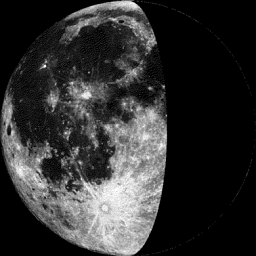
Moon Phase March 23rd
Waning Gibbous
===================
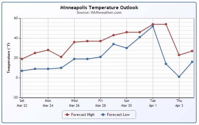
Minneapolis Temperature Trend
It is definitely not the March weather that we're used to. In fact, temperatures this weekend are running nearly 20F (or more) below average. Note that our temperatures look to be gradually warming through the first full week of Spring. Temperatures by the 1st of April could actually sneak into 40s and 50s... stay tuned!
Monday Snow Potential
The weekend looks to remain mostly quiet and cold, but a weak clipper system will scoot through the area on Monday with a slight chance of light snow. There could even be some light accumulations, which may have some impacts on your Monday commutes. Stay tuned for more!
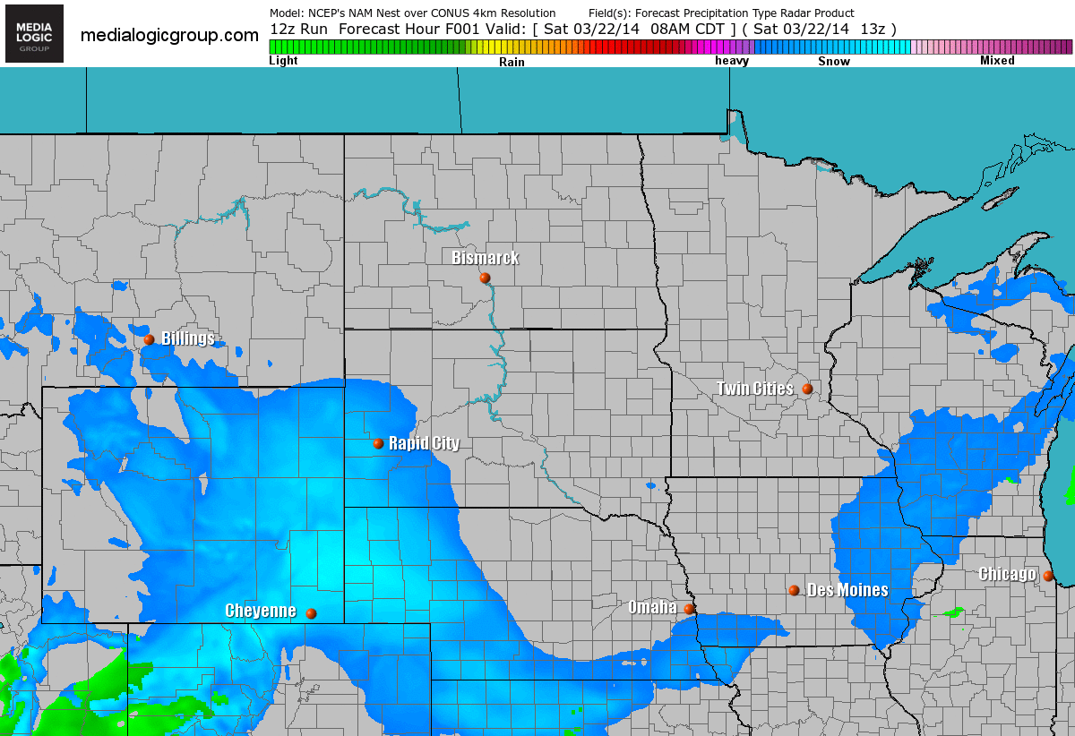
Monday Snow Potential
Here's a glance at our Monday snow potential. We'll have to watch, this could even be a shovelable snow for some across Minnesota and Wisconsin.
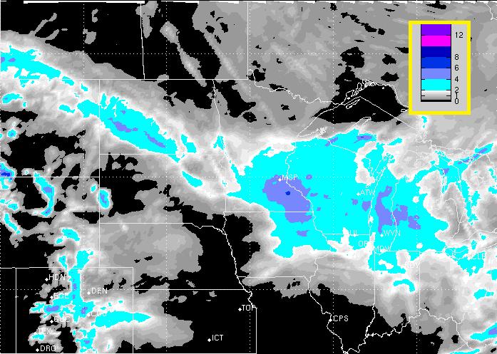
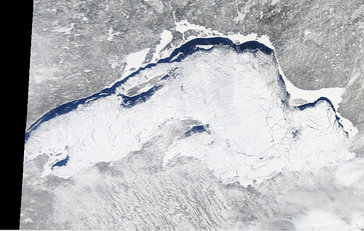
Lake Superior Ice
The MODIS satellite image from Saturday showed lots of ice still on Lake Superior. Interestingly, the recent northwesterly winds have shoved the ice to the south shore. There's actually so much ice on the lake that areas along the north shore are the only areas with exposed water.
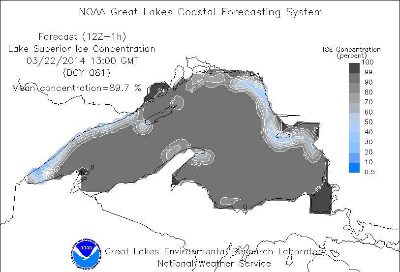
Lake Superior Ice
According to NOAA's GLERL, Lake Superior still had nearly 90% ice coverage as of Saturday!
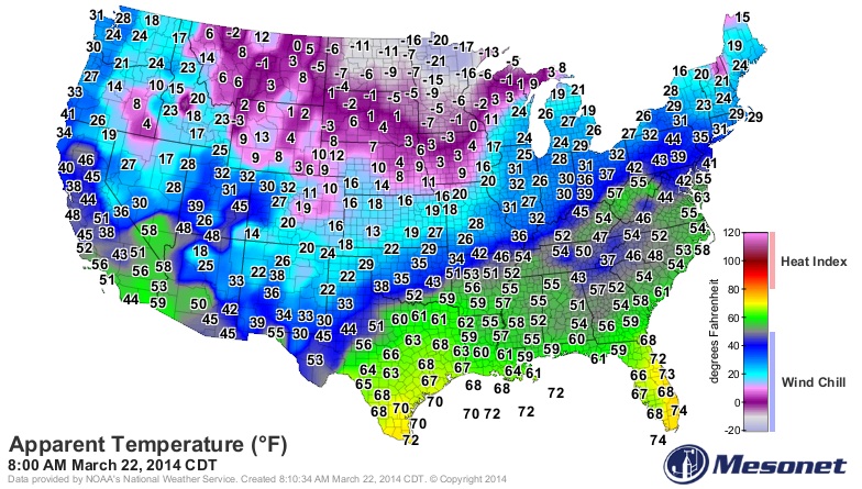
Cold Saturday Morning
I thought this was worthy enough to share, especially since it's the first weekend of Spring. The image below shows the "Feels Like" temperatures from Saturday morning. Note all the sub-zero wind chill values across the Upper Midwest. Crazy to think that -20F wind chill values can still pop up in late March!
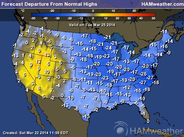
Continued Cold
What you see is what you get. The forecast into early next week is still suggesting significantly colder than average values across the eastern two-thirds of the country. The western part of the county looks to remain a little warmer than average.
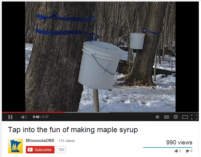
Maple Syrup
Warm days (above freezing) and cold nights (below freezing) are precious to some in search of pure Maple Syrup. It's about this time of year when maple trees can be tapped for sap and eventually boiled down into what we all know and love to be topped on our pancakes. The "Sap Run" will continue through March/April as long as we continue to get these warm days and cold nights. The MN DNR is actually hosting "Maple Syruping" events this weekend and through the end of the month.
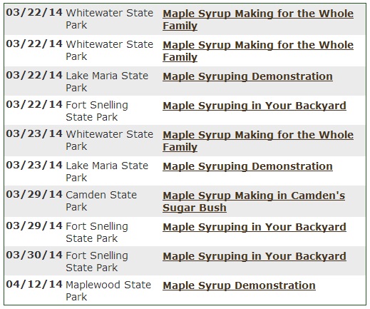
"Maple Syruping" Events
If you're interested in finding out more about the process, check out some of the "maple syruping" events hosted by the MN DNR through the end of March/early April.
Macy's Flower Show
If you're sick and tired of the cold weather, you might be interested in checking out the Macy's Flower Show, which starts Sunday and runs through April 6th! From what I hear, there are some amazing colors and arrangements. It certainly would be a great way to shake off the winter blues. The Flower Shows will be hosted in New York, Philadelphia, Chicago, Minneapolis and San Francisco.

Household Insecticides Linked to Colony Collapse Disorder in Bees?
WOW! Here's an interesting story about household insecticides and how that may be playing a BIG role in declining bee populations. The story comes from Becky Beyers and the University of Minnesota, a very good read!
"Vera Krischik and her lab in the Department of Entomology are exploring a different avenue: how neonicotinoids, a group of insecticides commonly used in urban gardens and forests as well as in agricultural fields, might be making bees less resistant to the parasites and pathogens that researchers now believe are likely causes of Colony Collapse Disorder."
(Image courtesy: University of Minnesota)

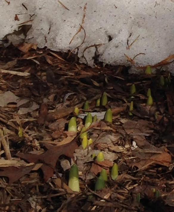
Signs of Spring?
Thanks to @Anneflo from Eden Prarie, MN for the picture and the humor! She says: "First day of Spring, where the snow has melted in front of the house. A miracle after this polar-vortexian winter."
NICE!
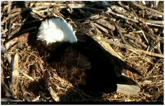
Eagle Cam
Our resident Bald Eagle is still sitting on her eggs in Minnesota. I caught mama taking a Saturday afternoon snooze...
Hawk Cam
Here's another great live cam out of Ithaca, NY of a Red-Tailed Hawk sitting on eggs.

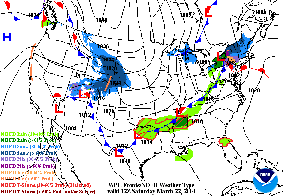
Weather Outlook
Here's the latest weather outlook across the nation through Monday. A few areas of interest include rain in the southern and southeastern part of the country through early next week, a snow chance along the Front Range of the Rockies through AM Sunday and an approaching clipper system in the Midwest by Monday.
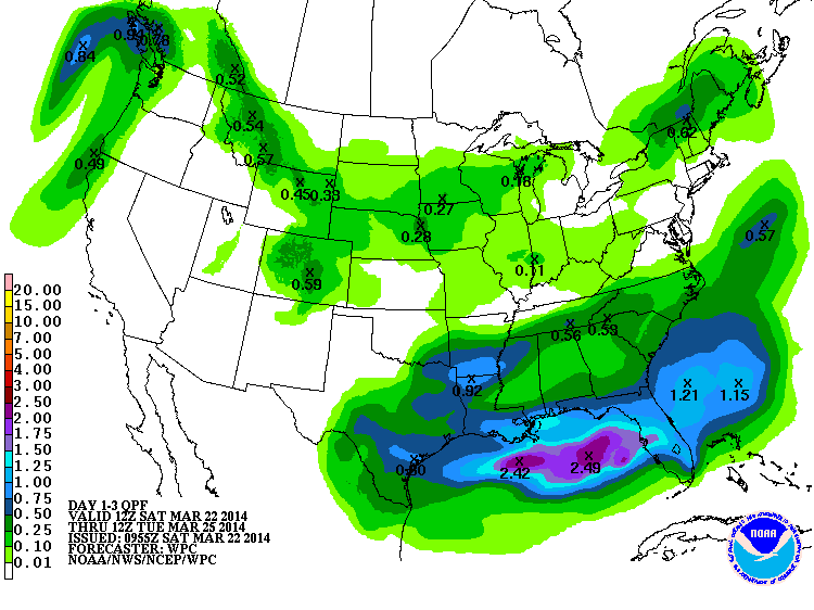
3 day Precipitation Outlook
Here's NOAA's 3 day precipitation outlook, which takes us into AM Tuesday. The heaviest precipitation will be falling across the southeastern part of the nation in the form of rain, but the precipitation across the northern part of the nation looks to be falling in the form of snow.
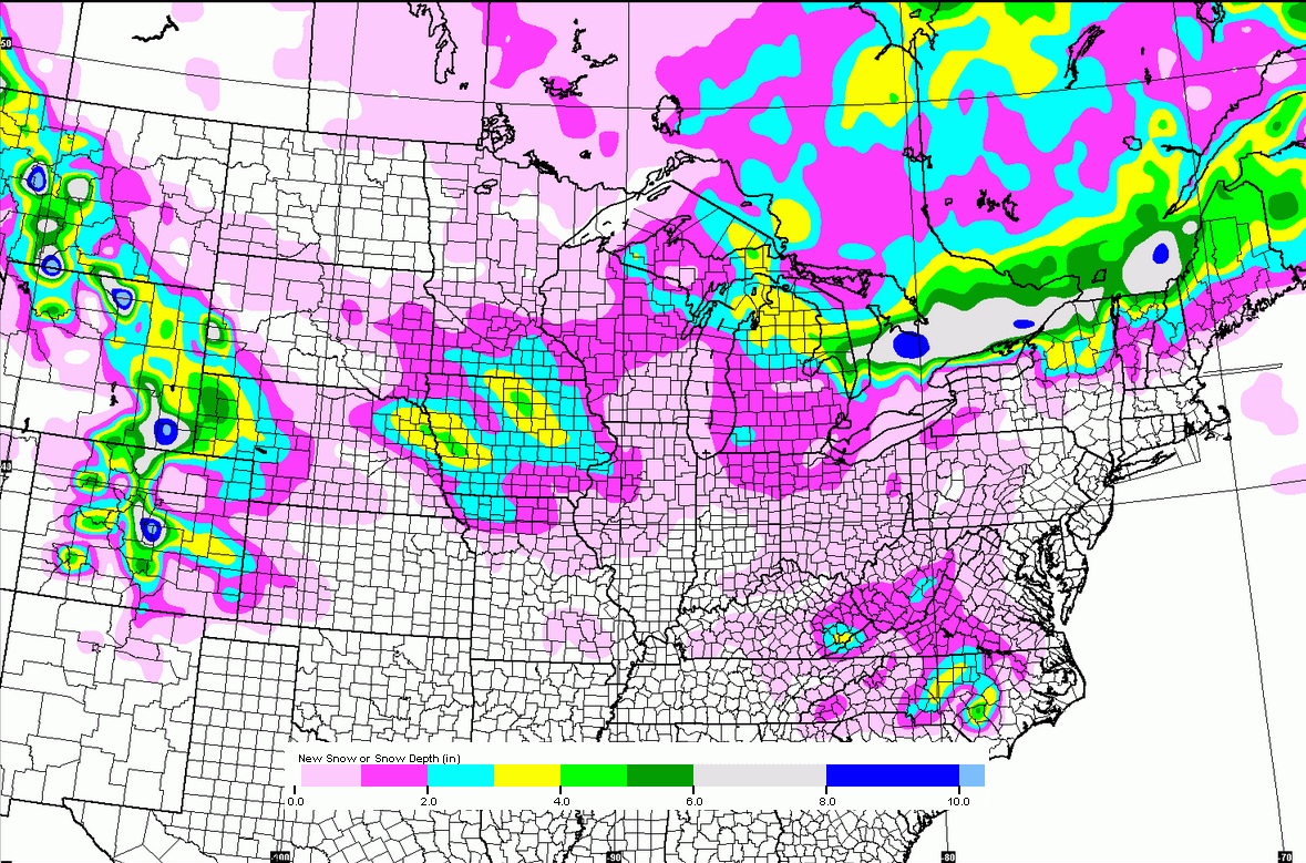
Snow Potential Through AM Tuesday
Here's the GFS (American model) snow potential through early next week.
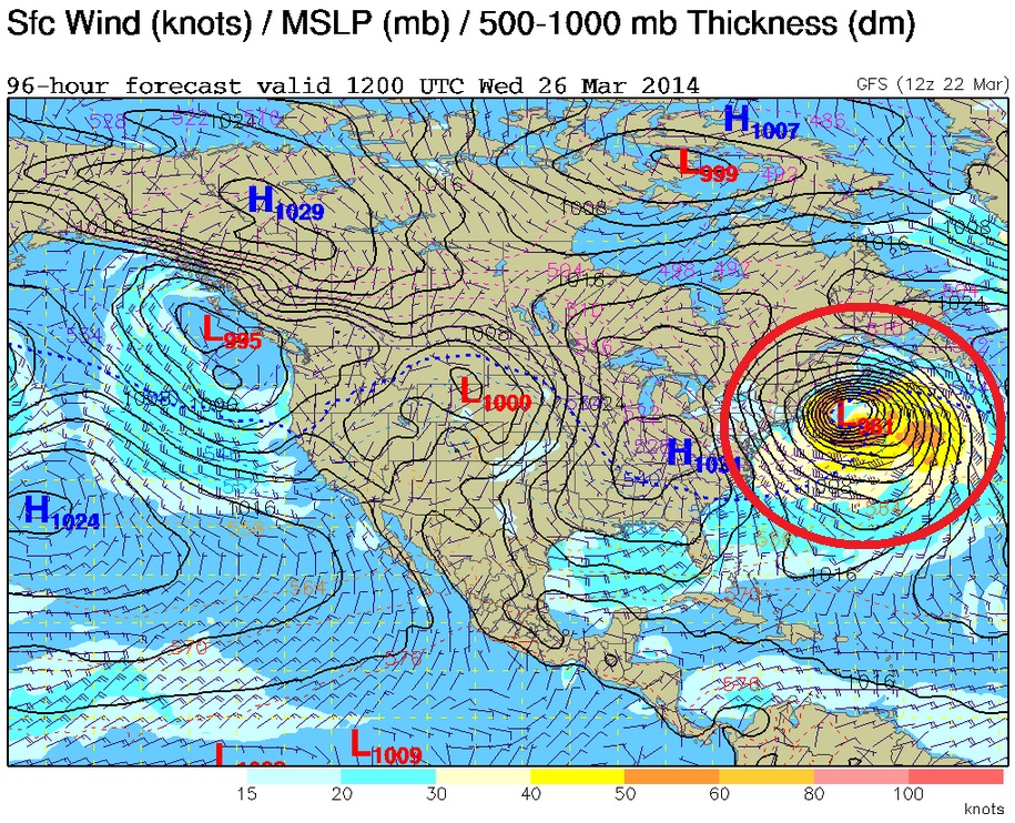
"Nor'Easter to Bomb Off Mid-Atlantic Coast Late Tuesday"
Those are the words from NOAA's Weather Prediction Center. Over the past several days now, extended weather models have been suggesting a fairly large storm rapidly developing along the east coast by early/middle part of next week. If everything lines up with how weather maps look now, this could be a big late season snow for folks in the Northeast.
...NOR'EASTER TO BOMB OFF THE MID-ATLANTIC COAST LATE TUESDAY...
THE CROSS-POLAR FLOW WHICH HAS PERIODICALLY REACHED INTO NORTH AMERICA SINCE JANUARY SEEMS DESTINED FOR AT LEAST ONE MORE TRANSPORT OF ARCTIC AIR INTO MUCH OF THE CENTRAL AND EASTERN UNITED STATES TUESDAY. WITH HEIGHTS STILL LOW ACROSS THE EAST IN THE WAKE OF THE COLD BLAST DURING SUNDAY AND MONDAY IN THE SHORT RANGE, THE STAGE WILL BE SET FOR ANOTHER ROUND OF SNOW AND ICE WITH THE CLIPPER SYSTEM HERALDING TUESDAY'S OUTBREAK. IT SEEMS THAT THE CLIPPER WILL GAIN ENOUGH AMPLITUDE TO SIPHON SOME SUBTROPICAL MOISTURE AND ENERGY CROSSING THE SOUTHEAST FROM THE GULF OF MEXICO EARLY TUESDAY. MOST OF THE GLOBAL NUMERICAL MODELS INDICATE THAT THE SLIGHT NEGATIVE-TILT TO THE CLIPPER WILL SET UP A DUMBBELLING WITH THE GULF ENERGY TOWARD EVENING TUESDAY SOMEWHERE OFFSHORE BETWEEN CAPE HATTERAS AND THE ATLANTIC "BENCHMARK" OF 40N/70W. THIS BINARY INTERACTION--OR FUJIWHARA EFFECT--IS A PARTICULARLY ENERGIZING PHENOMENON. BY EARLY WEDNESDAY MORNING, A SUB-970MB SURFACE CYCLONE IS LIKELY NEAR THE BENCHMARK AFTER THE BOMBING PHASE. HOW FAR SOUTHWEST THE BOMBING OCCURS IS CRITICAL FOR THE SENSIBLE WEATHER FROM THE CAROLINAS TO NEW ENGLAND. THE EARLIER/FARTHER SOUTHWEST, THE GREATER THE CHANCES FOR SIGNIFICANT WINTER WEATHER FROM THE CAROLINAS AND SOUTHERN MID ATLANTIC ALL THE WAY THROUGH MAINE. IF THE BOMBING IS LATER/FARTHER NORTHEAST, EASTERN NEW ENGLAND WOULD SUFFER THE WORST EFFECTS. EITHER WAY, WINDS LOOK REMARKABLY STRONG ON THE WEST AND SOUTH SIDE OF THE TIGHT CIRCULATION TUESDAY NIGHT INTO EARLY WEDNESDAY--A MAJOR CONCERN FOR COASTAL AND OFFSHORE INTERESTS FROM EASTERN LONG ISLAND TO DOWN EAST MAINE.
AFTER THE EAST-COAST STORM, THE AMPLITUDE OF THE FLOW ACROSS THE NATION SHOULD RELAX SOME, THOUGH THE GENERAL BACKGROUND PATTERN APPEARS TO REMAIN. USED A RECENT ECENS MEAN TO HANDLE THIS PHASE OF THE FORECAST. THE NORTHWEST SHOULD CONTINUE TO BE UNSETTLED IN STRONG ONSHORE FLOW, WITH THE SOUTHWEST RELATIVELY SHELTERED DUE TO THE SPLITTING. MUCH OF THE EASTERN UNITED STATES LOOKS WET, WITH THE GULF OF MEXICO OPENING VIA RESIDUAL BROAD TROUGHING.
CISCO
===============
Here's a look at what the storm could resemble by Wednesday morning. Note the significant wind field that would be surrounding this particular event. This, no doubt, will have notable impacts on places in the Northeast not only in a sense that wind will be an issue, but significant snow could also be an issue. Stay tuned for more on this developing storm.
Thanks for checking in and enjoy the rest of your weekend! Don't forget to follow me on Twitter @TNelsonWNTV

No comments:
Post a Comment