By Todd Nelson
Our score card for March would look pretty good if we actually playing golf, but since we're talking temperatures, our near 7 under average is not necessarily a good thing. Thanks to a pretty persistent flow out of Canada since late last year, we haven't really been able to buck the trend of below average temperatures.
Another surge of cold weather plagues the region this weekend. High temperatures today and tomorrow will be running nearly 20F or more below average! Catch 22, the sun feels warm, but the air will be disturbingly cold.
I have to admit, I'm getting pretty excited to start planting stuff in the garden this year. I know we are still several weeks out from even thinking about attempting to do any outdoor gardening, but the itch is near. Even though we are from Spring fever setting in fully around here, I've been filling the void by watching great YouTube videos on planting and vegetables gardens.
If you're interested in starting seeds on your own, the U of M has a great list of dates when you can start. Interestingly, you can already start things like peppers, cauliflower and cabbage! Wait on tomato seeds until early April. Good luck!
======================================
FRIDAY NIGHT: Lingering light snow showers early. Gradual clearing. Still breezy and quite chilly. Low: 10. Winds: NW15-30
SATURDAY: Brisk winds! Where's Spring? High: 19. Winds: NW 10-15.
SATURDAY NIGHT: Cold. Low: 5. Winds: NW 10.
SUNDAY: Feels February. Far from Spring fever. High: 22.
MONDAY: Chance of light snow. Wake-up: 11. High: 31.
TUESDAY: Gradual clearing, still chilly. Wake-up: 11. High: 24.
WEDNESDAY: Clouds thicken, light mix late in northern MN? Wake-up: 12. High: 36.
THURSDAY: Chance of rain/snow. Wake-up: 23. High: 37.
FRIDAY: Quieter. Still below average temps. Wake-up: 20. High: 33.
======================================
This Day in Weather History
March 22nd
1991: Ice storm began during the afternoon and ended as the event changed to heavy, wet snow on the 23rd. This event coated the city of Duluth with as much as 6 inches of ice. The 850-foot WIDO TV tower was toppled. 4 million pine trees were damaged or destroyed with the heaviest damage at G.C. Andrews State Forest near Moose Lake in Pine County.
1952: Snowstorm dumps 13.2 inches on the Twin Cities.
=====================================
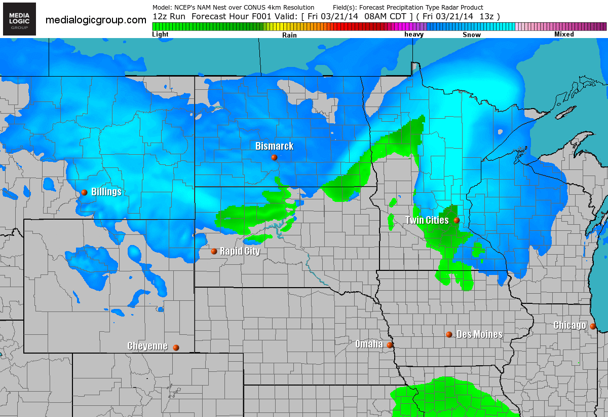
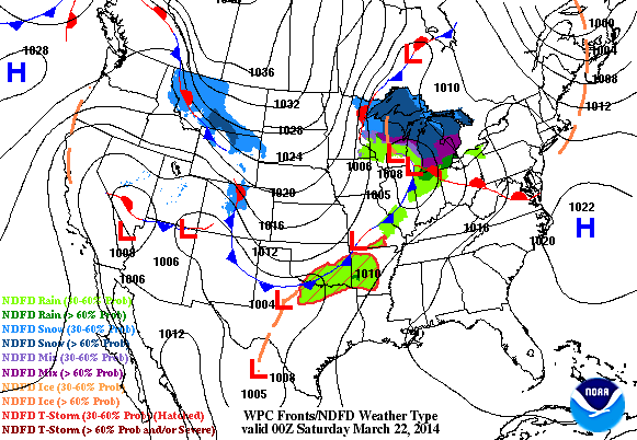
Weather Outlook
A storm system responsible for up to 12" of snow near International Falls, MN on Friday and strong gusty winds across the rest of the state, will finally be gone by the weekend. Unfortunately, the storm will also be responsible for a significant cool down this weekend with high temperatures running nearly 20F (or more) below average.
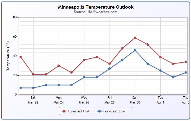
Minneapolis Temp Trend
Cold temperatures will persist through the weekend with slightly warmer temperatures moving in during the first full week of Spring. We're still getting indications that a more significant warmup will move in by next weekend... Stay tuned!
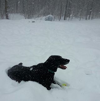
Friday Snow
A fast moving clipper system dumped quite a bit of heavy snow across northern MN late this week. Here's a picture from my good friend Amanda Graning and her dog Jig out of Duluth, MN. Looks like Jig was enjoying the snow!
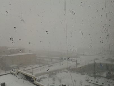
Snowy First Full Day of Spring in Duluth
Here's another picture from Duluth thanks to my good friend Bruce Truckey.
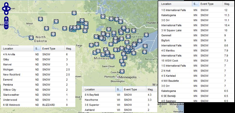
Snow Totals
Here are some of the very impressive snow totals that came in on Friday. Note the near 12" that fell around the International Falls, MN region! There were also blizzard reports coming from the Red River Valley area near the ND/MN state line.
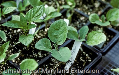
Spring Planting Fever?
If you have a green thumb and have never tried planting your own vegetable seeds for you summer garden, you might want to give it a try. I actually did it for the first time last year and not only did I have a great time, but my plants turned out great! You can actually start planting some of your seeds now (depending on plant) to get them in the ground by April or May.
Here's some great information from the University of Maryland Extension, they even have videos for you to watch!
"Starting seeds indoors is about as much fun as a food gardener can have in late winter! The idea is to grow baby plants (a.k.a. transplants or starts) for 2-8 weeks (depending on the vegetable and rate of plant growth) and then plant outdoors where the crops will mature and be harvested. Just about any crop can be started inside and transplanted outside. With a small investment and bit of space you can grow hundreds of healthy transplants. All of the supplies you need can be found at home (reused food containers for starting seeds) or purchased locally from hardware stores, garden centers, and big box stores. Growing your own transplants
*Saves you money- this may take a few years since there are first-year set-up costs
*Increases your garden’s output- get earlier harvests by starting with transplants instead of seeds
*Allows you to grow the crops and cultivars you like best rather when you need them- no need to plant only what’s available in retail stores
*Gives you better control of germination and plant stand- fewer skips, no thinning
*Lessens pest and weather risks- no worries about cool, wet weather keeping you from planting or encouraging seed rotting diseases."
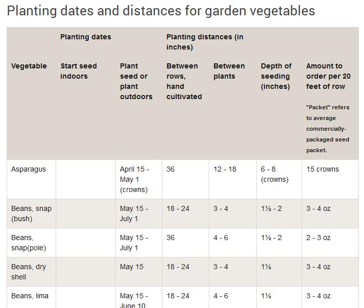
Minnesota Seed Sowing Dates
It obviously matters when your average last frost date is for your specific area and that will largely depend on where you live. The University of Minnesota has a nice list of when you can start your seeds indoors based on Minneapolis' average last frost date.
See the complete list from the University of Minnesota HERE:
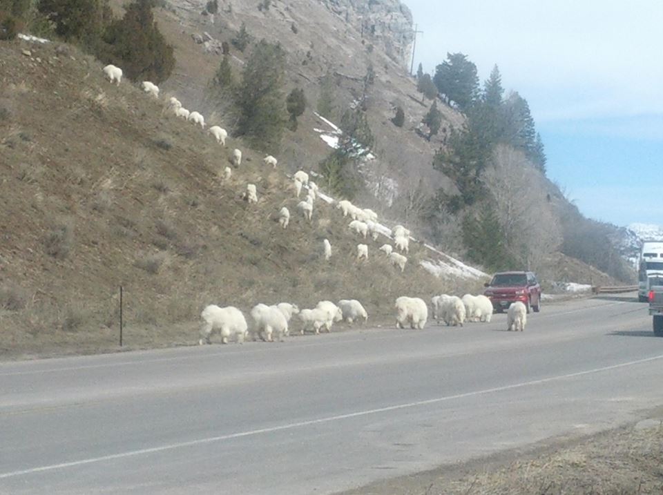
Mountain Goat Gridlock
HA! Thanks to the Wyoming Dept. of Transportation for the image below, which shows a different kind of traffic jam at the Snake River Canyon.
Weather Outlook
The winter storm that dumped up to a foot of snow in northern Minnesota will continue to push east through the weekend. It'll eventually end up in the Northeast by Saturday, but should be mostly gone on Sunday. Cold air will move in behind the front and set the stage for a little wintry precipitation across the Mid-Atlantic region by Sunday. There will also be snow developing along the Front Range of the Rockies over the weekend.
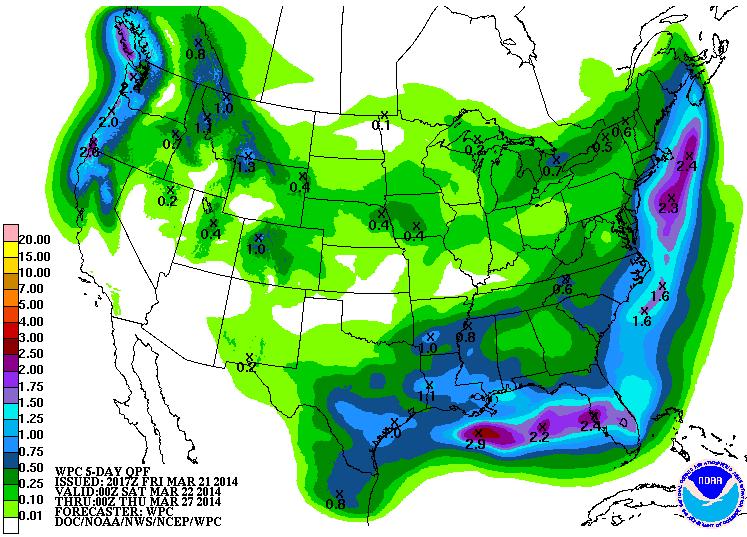
Precipitation Potential
According to NOAA's HPC 5 day precipitation forecast, there is still a decent response to a heavier swath of precipitation running north just east of the East Coast. Some of the longer range weather models are still suggesting a larger storm developing around early/mid week next week just east of New York and Boston. It'll be interesting to see if this potential storm continues to show as much promise as it has been in the past few days... stay tuned!
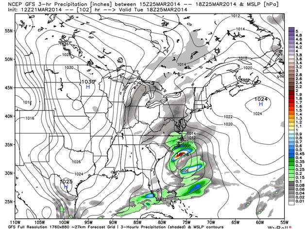
Developing East Coast Storm?
Longer range models continue to indicate a more sizable storm potentially developing near the East Coast by the early/middle part of next week. It's still way to early to give exact details on how this could impact the East Coast/Northeast or if it will at all, but it's worth keeping an eye on.
Temperature Outlook
As we head into the weekend, temperatures will continue to tumble across the eastern two-thirds of the nation. This much colder than average weather will stick around into next.
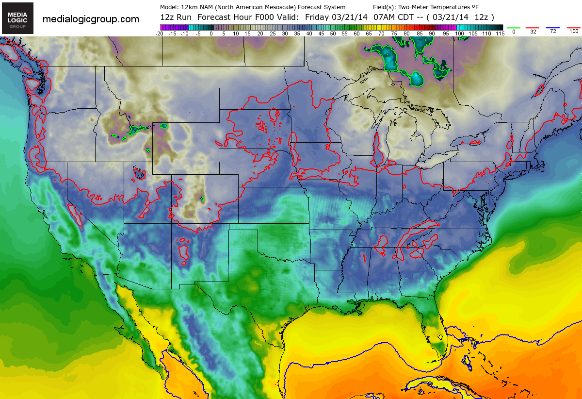
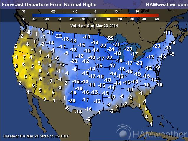
Sunday Highs From Normal
Just to give you an idea of how cold this weather will be for this time of the year, here it is! Temperature readings across the eastern two-thirds of the nation will be nearly 10F to 25F colder than average in many spots!
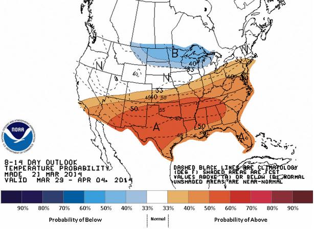
Signs of Warming?!
Alright... this is somewhat promising! According to NOAA's CPC, the 8 to 14 day temperature outlook, which takes us into the early part of April, suggests that temperatures may actually sneak up to above average levels for a change. Stay tuned for this developing situation!
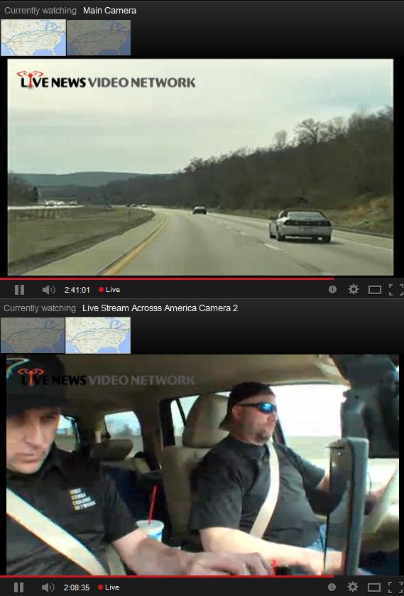
Live Stream Across America
Technology has come a long way in recent years and here's a great example of that. 2 storm chasers (Douglas Kiesling and Ben McMillan) started driving from New York, NY on Friday and will drive cross country to Santa Monica Beach, CA while streaming video NONSTOP.
"StormChasingVideo.com LLC, and The Iowa Storm Chasing Network are proud to announce a partnership in a coast-to-coast journey this weekend to test out the latest technology in live mobile newsgathering.
In partnership with Google Corporation’s YouTube.com, Kiesling and McMillan will attempt to make the approximately 2,900 mile drive from Times Square, New York to Santa Monica Beach, California NONSTOP while streaming live video to YouTube LIVE starting at 1pm Eastern Time on Friday, March 21 2014."
You can watch their trip LIVE on YouTube HERE:
Thanks for checking in and have a great weekend ahead! Don't forget to follow me on Twitter @TNelsonWNTV

No comments:
Post a Comment