40 F. high in the Twin Cities Thursday.51 F. average high on April 3.
48 F. high on April 3, 2013.
Winter Storm Warning in effect this morning.
PM commute considerably more user-friendly than morning slog.
60+ warmth returns next week.
 Snowmageddon Averted?
I
have vivid memories of my first April here, back in 1983. On April 14,
1983 13.6 inches of snow DELIGHTED residents of the Twin Cities. A cool
foot of snow blanketing green lawns and dazed robins?
Not. Good.
I wondered what I had gotten myself into.
After
the aggressive winter we've just muddled through this feels like piling
on, rubbing salt in the wound. But latest guidance suggests we'll pick
up a total of 4-7" of concrete-like slush; enough to shovel & plow -
but we may miss out on that ominous "foot of snow" after all, although
some northern/western suburbs may pick up close to 10" by late morning.
That's quite enough, thank you. Snow tapers this morning with slowly
improving travel conditions this afternoon. The drive home won't be
quite as traumatizing.
The 6th coldest meteorological winter on
record meant that most storms fell as snow; we didn't have enough warm
air to trigger much ice or rain, making snowfall predictions more
straightforward. Our current storm pulled enough warm air aloft into
Minnesota for ice and rain, and that helped to keep final snowfall
tallies down a bit.
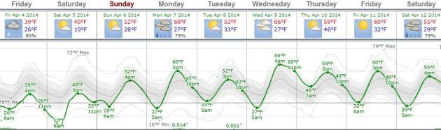
Your reward for tip-toeing through the slush this morning? 50s return next week, even a shot at 60 by Wednesday afternoon.
Full disclosure: I'm off my meds, but I suspect this will be the last (significant) snowfall of the season.
We WILL see green by late April. We WILL be able to sweat it out up at the cabin this summer. This too shall pass.
*
photo of the Oscar Meyer Wienermobile circling Duluth earlier in the
day Thursday, where up to 12" was expected by midday today, courtesy of
Clint Austin.
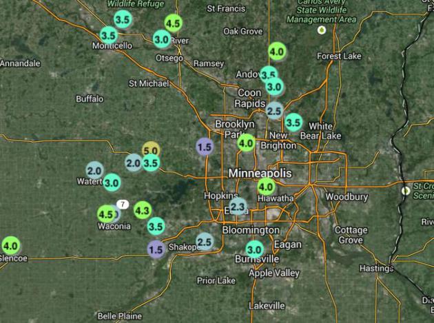
Snowfall Amounts. I snapped this frame-grab around 11 PM last night, when much of the metro had already picked up a good 3-4" snow.
Click here
for the latest amounts, courtesy of the Twin Cities National Weather
Service. A detailed list of additional reports can be found
here.
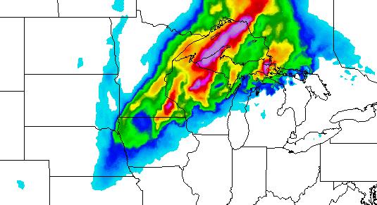
RAP Solution.
Last night's RAP shows a few bands of heavier snow setting up east, and
northwest of the MSP metro area, where some localized 8-10" amounts are
expected. The immediate metro may wind up with closer to 4-7" heavy wet
snow, enough to turn the morning commute into a gasp-worthy,
white-knuckle adventure. Map: NOAA and Ham Weather.
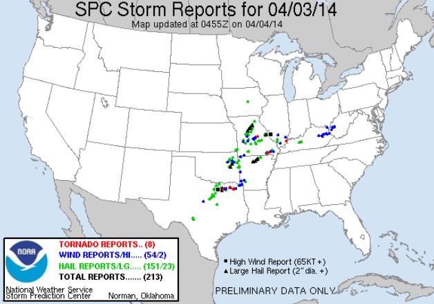
Thursday Severe Weather Outbreak.
Although not as bad as feared, SPC counted up 8 tornadoes as of
midnight, including the suburbs of St. Louis and the Denton area, just
north of Dallas, Texas.
Click here for a list of severe storm reports.
Spring Redux.
I realize it looks like the opposite of spring out there right now, but
whatever snow is in your yard will be mostly-gone by Sunday afternoon
as temperatures push above 50F. ECMWF guidance shows a high near 60F for
the Twins Home Opener Monday, maybe mid 60s by Wednesday. Bring it.
Source: Weatherspark.
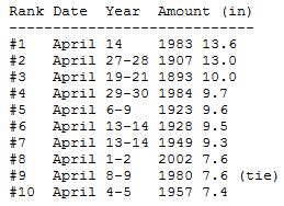
Historic April Snowstorms. Will we set a record today? I doubt it - I don't believe today's storm will rival April 14, 1983. Here are details from the
Minnesota Climatology Working Group: "
The
largest April snowstorm in the Twin Cities happened on April 14, 1983. A
strong area of low pressure had ample moisture to work with and
deepened over northern Iowa as it moved to the east and northeast. The
event started as rain on the 13th and changed over to snow during the
wee hours of April 14th. Persons in east central Minnesota were
surprised to wake up to a foot of snow on the ground with brilliant
morning sunshine. The grand total at the Twin Cities airport from that
storm was 13.6 inches. The Metrodome deflated for the third time since
its construction in this storm. (The first two times were Nov 21, 1981
and December 30, 1982.) Over 400 schools canceled class on April 14 and
the University of Minnesota shut down at 2:30pm. Residential mail
deliveries and pickups were canceled for only the third time in 20
years. The Twin Cities International Airport was shut down for 5 hours
from 9am to 2pm on the 14th..."
How Sleep Deprivation Drives The High Failure Rate Of Tech Start-ups.
No, it appears pulling all-nighters won't necessarily save your
company, but getting a good night's sleep - consistently - just might.
Here's a clip from
Forbes: "...
While
the tech industry is the subject of special fantasies of how
exponential profits can spring from just a few people working together
on laptops, three out of every four startups fail.
Could it be that the myth of the obsessive careerist whose dedication
to work follows him to bed every night is actually a grand farce of
worst practices and general dysfunction? It may be that accepting the
normalcy of non-stop work is encouraging a culture of unusually bad
thinking, painstakingly propped up by those charged with turning thought
into real product..."
TODAY:
Winter Storm Warning.
4-7" slush, up to 10" piling up over the northern/western suburbs of
the metro area. Snow tapers by midday with slowly improving travel this
afternoon and evening. Winds: NW 25. High: 35
FRIDAY NIGHT: Partial clearing, winds ease. Icy patches linger. Low: 19
SATURDAY: Partly sunny and milder. High: 42
SUNDAY: Intervals of sun, hints of spring. Wake-up: 31. High: 52
MONDAY: Stray (rain) shower for Home Opener. Wake-up: 32. High: 58
TUESDAY: Some sun, cooler breeze. Wake-up: 33. High: 52
WEDNESDAY: Partly sunny. This is more like it! Wake-up: 30. High: 62
THURSDAY: Mix of clouds & sun, turning cooler. Wake-up: 44. High: 55
Climate Stories....
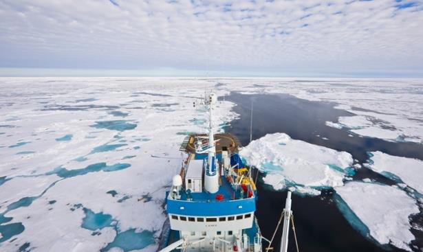
Arctic Sea Ice Falls To Fifth Lowest Level On Record.
The Guardian
has the latest on a trend at the top of the world that may be having a
domino effect, impacting weather systems across the Northern Hemisphere.
Here's an excerpt: "
Arctic sea ice remained on its death spiral on
Wednesday, with the amount of winter ice cover falling to its fifth
lowest on the satellite record, scientists at the National Snow and Ice
Data Center said. The scientists said Arctic
sea ice extent for March averaged 14.80m sq km. That's 730,000 sq km
below the 1981-2010 satellite average. The latest findings reinforce a
trend that could see the Arctic losing all of its ice cover in the
summer months within decades..."
Photo credit above: "
The scientists said Arctic sea ice extent for March averaged 4.80m sq km – well below the monthly average of the past 30 years." Photograph: Jenny E. Ross/Corbis.
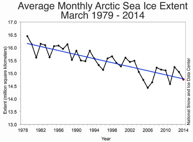
Less Ice At The Top Of The World. March trends since 1978, courtesy of
NSIDC, The National Snow and Ice Data Center.
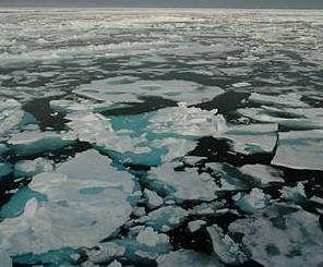
NSIDC, NASA Say Arctic Melt Season Lengthening, Oceans Rapidly Warming. Here's an excerpt from
Space Daily: "
The
length of the melt season for Arctic sea ice is growing by several days
each decade, and an earlier start to the melt season is allowing the
Arctic Ocean to absorb enough additional solar radiation in some places
to melt as much as four feet of the Arctic ice cap's thickness,
according to a new study by National Snow and Ice Data Center (NSIDC)
and NASA researchers. Arctic sea ice has been in sharp decline during
the last four decades. The sea ice cover is shrinking and thinning,
making scientists think an ice-free Arctic Ocean during the summer might
be reached this century. The seven lowest September sea ice extents in
the satellite record have all occurred in the past seven years..."
Photo caption: "
Some areas, such as the Beaufort and Chukchi Seas, are freezing up between six and 11 days later per decade."
The U.N.'s New Focus: Surviving, Not Stopping, Climate Change. Adaptation is a given, seeing that nations have yet to get serious about mitigation.
The Atlantic has the story - here's a clip: "...
As
a result, we need to adapt to a warming planet—to minimize the risks
and maximize the benefits associated with increasing temperatures—rather
than focusing solely on curbing warming in the first place. And it's
businesses and local governments, rather than the international
community, that can lead the way. “The really big breakthrough in this
report is the new idea of thinking about managing climate change,” Chris
Field, the co-chair of the UN's Intergovernmental Panel on Climate
Change (IPCC) study, said this week, adding that governments, companies, and communities are already experimenting with “climate-change adaptation...”
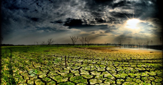
Warming Temperatures Could Dry Out One Third Of The Planet.
Climate Central has the story - here's the introduction: "
Warming
temperatures, scientists say, can tip places into drought conditions by
increasing evaporation and sapping soil of its moisture. A new study
suggests up to a third of the Earth's land area could be subject to
drier conditions because of warmer temperatures, not just changing precipitation patterns, by the end of the century.
The study finds that one of the agricultural heartlands of the United
States, the Central Plains, could become drier, even though it may not
receive less rain in the future, simply because warmer temperatures will
drive evaporation to dry out the rich soils. Drier soil makes it harder
to grow the food that feeds the country, which can have knock-on
effects on trade and national security..."


No comments:
Post a Comment