By Paul Douglas
A silver lining to our cool, wet bias - no drought in 2014? NOAA's Climate Prediction Center forecasts a cooler, rainier May than average. And there's growing evidence that an El Nino event brewing in the Pacific may become a whopper later in 2014 and early 2015.
El Nino warming phases are triggered when trade winds weaken, allowing tropical warmth to be released into the atmosphere. They pop up every 2-7 years; the last big one was 1997-98, which resulted in the warmest atmospheric temperatures ever recorded, to date.
There is lingering doubt & uncertainty about the severity of the next El Nino, but if it strengthens on schedule it would probably mean a wetter, slightly cooler summer for Minnesota, with warmer than average conditions into next winter.
With whiplash the "new normal" don't be surprised if we go from the toughest winter in a
generation to a relatively easy winter next year. Then again, I may be dreaming.
The first waves continue Thursday, but the main event, a big, slow-moving storm, pushes across the Plains, with more heavy rain late Sunday & Monday - maybe ending as a rain/snow mix by Monday night.
Next week will feel like something out of mid-March.
======================
WEDNESDAY NIGHT: Periods of rain, heavy at times. Low: 43. Wind: SE 15-25mph
THURSDAY: Heavy rain, isolated thunder. Spotty street flooding? High: 54. Wind: E 10-20, turning west late.
THURSDAY NIGHT: Lingering showers. Low: 42. Wind: W 5-10.
FRIDAY: Some sun, drying out. High: 63
SATURDAY: Mix of sun and clouds. Wake-up: 41. High: 65
SUNDAY: Cloudy and soggy with periods of rain. Wake-up: 44. High: 52
MONDAY: Chance of a cold rain. High: 45
TUESDAY: Lingering light rain/snow mix, feels like March again. Wake-up: 29. High: 40.
WEDNESDAY: Partial clearing. Wake-up: 27. High: 40.
==========================
This Day in Weather History
April 24th
1854: Summertime at Ft. Snelling with temperatures in the 80's.
=========================
Sunrise/Sunset Times
April 24th
SUNRISE 613 AM
SUNSET 810 PM
=========================
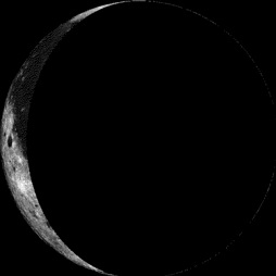
Moon Phase for April 24th at Midnight
3 Day After Last Quarter
===========================
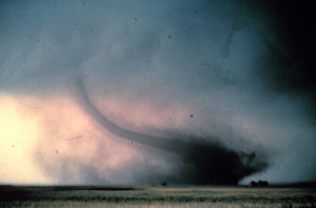
Severe Weather Awareness Week Continues...
Thursday: Tornado Safety Information
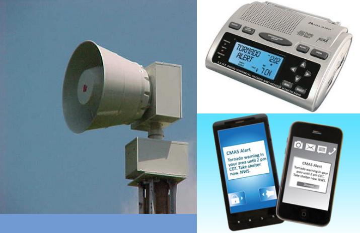
Before the Tornado...
Tornado watches highlight the area where tornadoes are most likely to develop. Continue with your normal activites, but keep informed of the latest weather information and be ready to get to shelter in case tornadoes develop quickly.
In the Home...
Go to the basement if possible. Get under a table, work bench, or some other sturdy furniture to avoid falling debris. A stairwell is also a good place to hide during a tornado.
If You Cannot Get to a Basement...
Go to a small interior room on the lowest floor. Closets, bathrooms, and interior halls afford the best protection in most cases, or try to hide under a bed. Get under something sturdy or cover yourself with blankets. Stay away from windows.
In an Apartment, School or Office Building...
Move to the inner-most room on the lowest level or to a pre-designated shelter area. Stay away from windows. If in a hallway, crouch down and protect your head from flying debris. Avoid areas with glass and large roof expansions.
In a Mobile Home, Car, Truck or Other Vehicle...
Abandon these as quickly as possible. Seek a sturdy shelter or permanent structure. Remember that many deaths occur when people try to drive away in a vehicle, but get caught in the deadly winds. Avoid bridges since they act as wind tunnels.
Tornado Watch/Warning Drills
The National Weather Service, Wisconsin Emergency Management, the Minnesota Division of Homeland Security and Emergency Management, and other state, county and local agencies have come together to host Severe Weather Awareness Week activities. On Thursday, April 24th, simulated tornado watches and warnings will be issued to test the statewide warning and communications systems. The schedule for April 24th is as follows:
(all times CDT)
1:00 PM: The National Weather Service will issue a simulated tornado watch for Minnesota and Wisconsin.
1:45 PM: The National Weather Service will issue a simulated tornado warning all of Wisconsin. Note that most cities and counties will activate outdoor warning siren systems.
1:45 PM: The National Weather Service will issue a simulated tornado warning for Minnesota counties. Note that most cities and counties will activate outdoor warning siren systems.
2:00 PM: The National Weather Service will issue an "End of Test" message using the Severe Weather Statement product. It should be stated that outdoor warning sirens will not be sounded again for this all clear, nor will there be any warning tone on NOAA Weather Radio.
6:55 PM: Another simulated tornado warning will be issued for Minnesota counties.
The 6:55 PM warning will be issued by the six National Weather Service offices that serve Minnesota. It will be issued as a test of family preparedness in the home and for second shift workers.
For the Minnesota and Wisconsin warnings, a TOR code (tornado warning) will be used to activate the broadcast on NOAA Weather Radios.
=====================
Weather Outlook
Weather conditions have certainly been a little more active as of late. The loop below shows two particular storms that we will be tracking. From heavy rain and severe weather potential to heavy snow across parts of the Great Lakes and Mountain West, it'll be active through next week.
Soggy Weather Continues
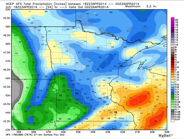
Wet weather returned Wednesday, but it looks to continue Thursday. The best potential for 1" to 2"+ total precipitation through the end of the week looks to be southeast of the Twin Cities. Some spots over extreme SE MN and into central/southern WI could see more than 2"!
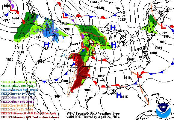
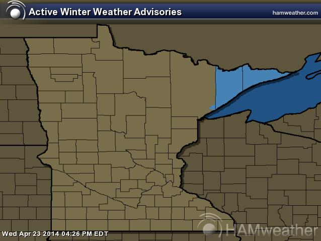
Winter Storm Watch
...SNOW HEADED BACK INTO THE PICTURE FOR NORTHERN MINNESOTA... .A LOW PRESSURE SYSTEM IS EXPECTED TO MOVE ACROSS THE NORTHLAND TONIGHT THROUGH FRIDAY. RAIN IS EXPECTED TO LIFT NORTHEASTWARD ACROSS THE REGION TONIGHT...AND MAY MIX WITH SOME SNOW OVERNIGHT. BY MIDDAY THURSDAY...MUCH OF THE PRECIPITATION IS EXPECTED TO CHANGE TO SNOW ACROSS THE MINNESOTA ARROWHEAD...WITH SNOW ACCUMULATION THURSDAY AFTERNOON THROUGH FRIDAY MORNING. AT THIS POINT...IT APPEARS INCREASINGLY LIKELY THAT 6 INCHES OF SNOW OR MORE WILL FALL ACROSS THE ARROWHEAD REGION. THE GREATEST AMOUNTS WILL LIKELY BE ON GRASSY AREAS...WITH LESSER AMOUNTS ON ROADWAYS DUE TO WARMER INITIAL SURFACE TEMPERATURES OF THE ROADS. LATER FORECASTS WILL TRY TO DETAIL SPECIFIC AMOUNTS...AND WARNINGS MAY BE ISSUED AS THE EVENT NEARS. IF YOU PLAN TO TRAVEL ACROSS NORTHERN MINNESOTA...ESPECIALLY IN THE ARROWHEAD...BE SURE TO STAY TUNED FOR MORE INFORMATION CONCERNING THIS STORM.
...WINTER STORM WATCH IN EFFECT FROM THURSDAY AFTERNOON THROUGH FRIDAY MORNING... THE NATIONAL WEATHER SERVICE IN DULUTH HAS ISSUED A WINTER STORM WATCH FOR HEAVY SNOW...WHICH IS IN EFFECT FROM THURSDAY AFTERNOON THROUGH FRIDAY MORNING.
* LOCATION...NORTHEASTERN MINNESOTA...INCLUDING TWO HARBORS... ISABELLA...SILVER BAY...LUTSEN...GRAND MARAIS...GRAND PORTAGE AND THE GUNFLINT TRAIL.
* TIMING...NOON THURSDAY THROUGH NOON FRIDAY. * SNOW...MORE THAN 6 INCHES OF SNOW WILL BE POSSIBLE IN THE WATCH AREA.
* WINDS/VISIBILITY...EAST WINDS WILL GUST TO MORE THAN 20 MPH.
* IMPACTS...DRIVING CONDITIONS ARE EXPECTED TO DETERIORATE THURSDAY AFTERNOON AND THURSDAY NIGHT ACROSS THE MINNESOTA ARROWHEAD. THE SNOW WILL INITIALLY MELT...ESPECIALLY ON ROADWAYS. HOWEVER...AS THE DAY WEARS ON THERE WILL BE A SLIPPERY AND WET ACCUMULATION OF SNOW. AS THE SNOW TURNS OVER TO MAINLY ALL SNOW...IT WILL ACCUMULATE AT AN INCREASED PACE LATER THURSDAY AND THURSDAY NIGHT. SOME FREEZING RAIN MAY ALSO FALL FOR A PERIOD OF TIME.
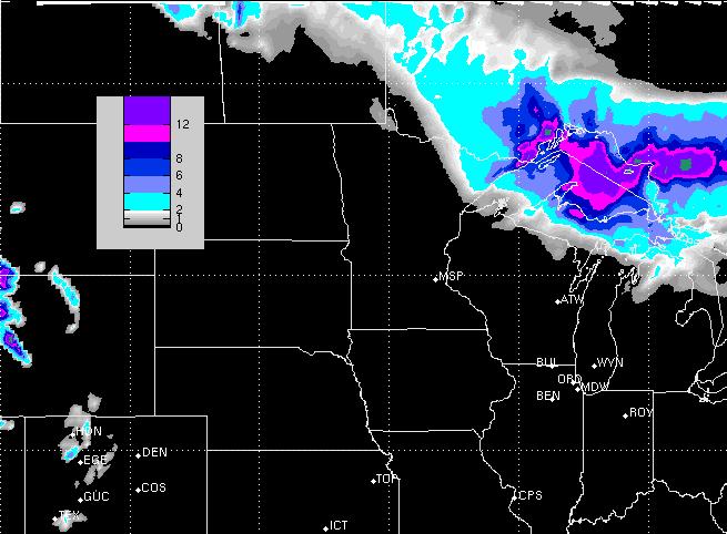
Snow Potential
As our next storm system pushes through the Midwest, temperatures will be cold enough across the far northern reaches of the state to produce snow. At this point, the best potential for several inches of slushy snow will be across the northeastern part of the state and the U.P. of Michigan.
Slow Motion Spring
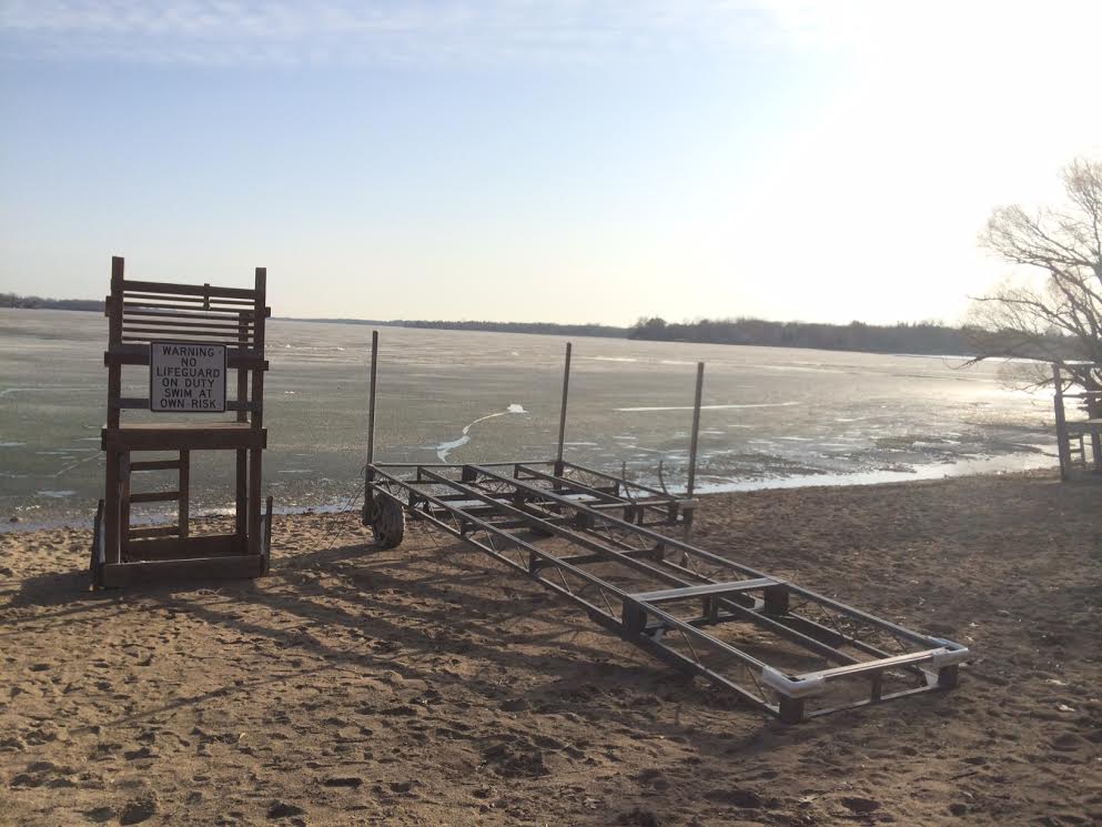
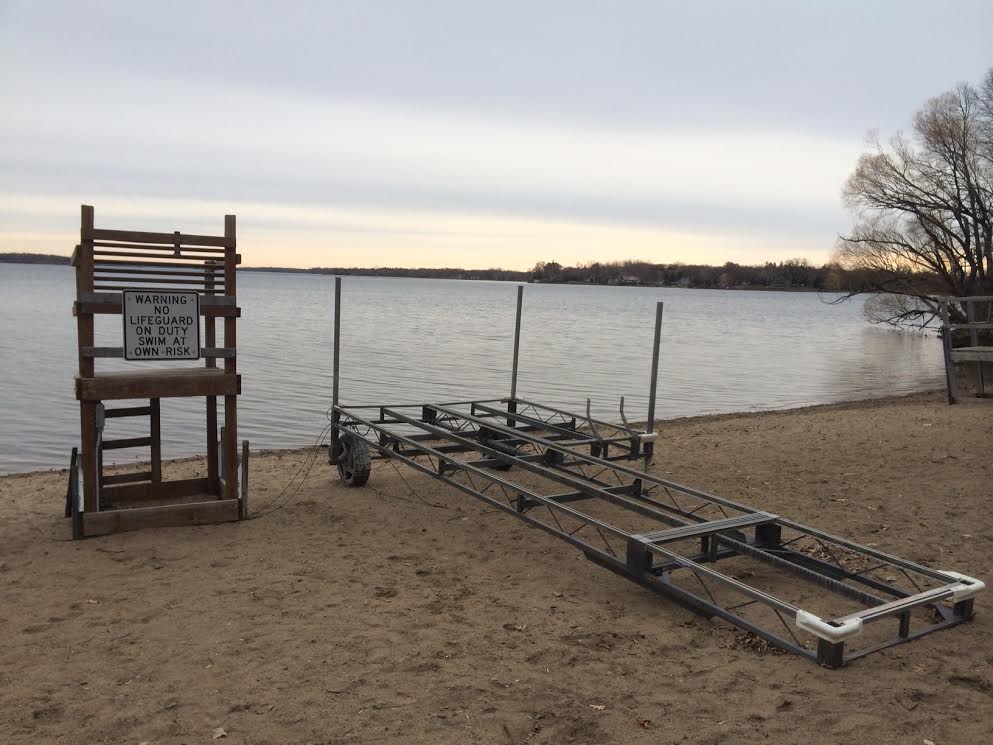
Even though temperatures have been running below average, we've actually seen quite a bit of lake ice melt close to home in recent days. I snapped these pictures from the Lake Minnetonka beach in Excelsior, MN. Note the drastic ice melt from Monday to Wednesday.
Monday, April 21st
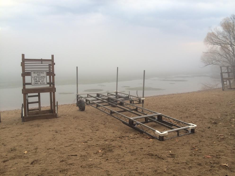
Tuesday, April 22nd
Wednesday, April 23rd
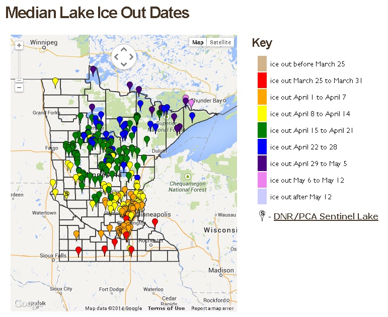
Metro Lakes Ice Out
According to MN DNR, there have been several lakes across the metro that have seen ice out! Calhoun, Harriet, and Lake of the Isles actually were ice out as of this last weekend! As of April 23rd, Lake Minnetonka was not quite ice out yet.
See more ice out information from the MN DNR HERE:
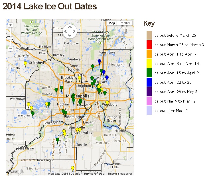
2014 Minnesota Ice Outs
Ice outs across southern MN have been coming in a little more frequently now with the latest warm air, but we are actually running a little behind normal.
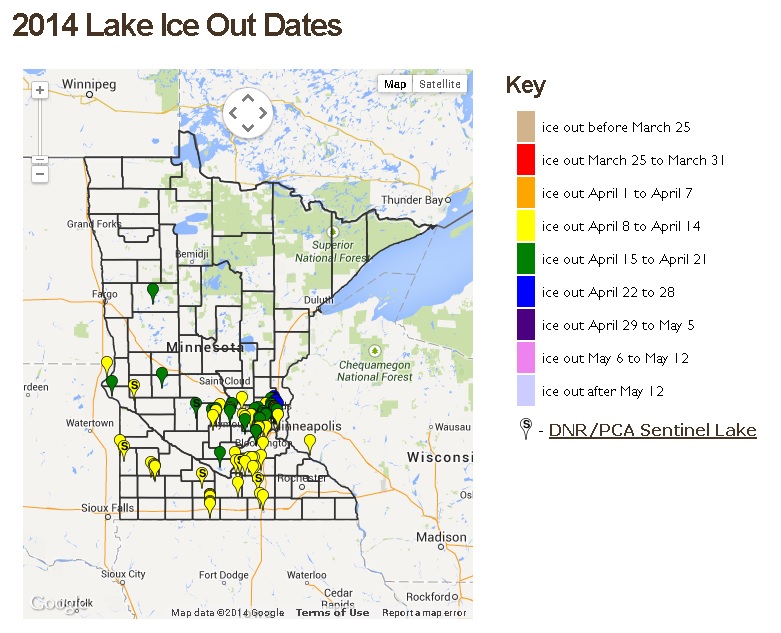
Average MN Ice Out Dates
According to MN DNR, the average ice out dates for some of our northern lakes typically don't come until the end of April/early May
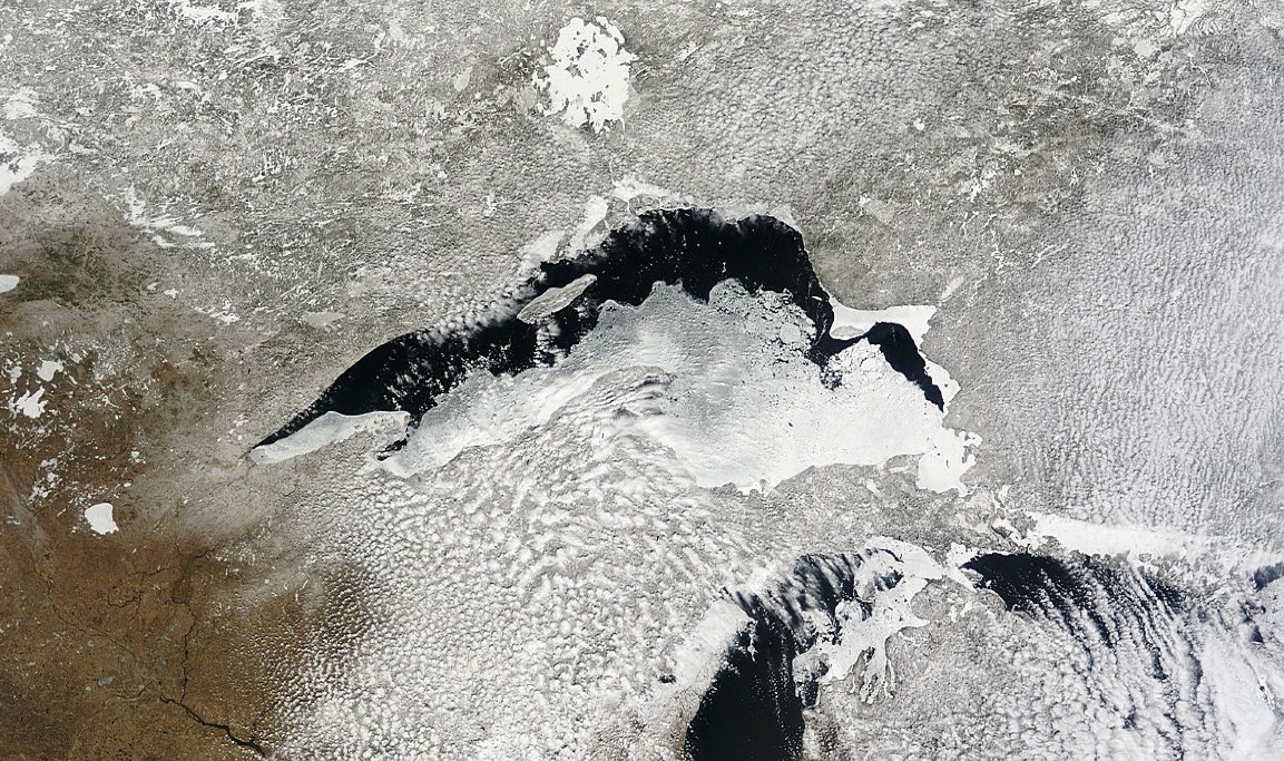
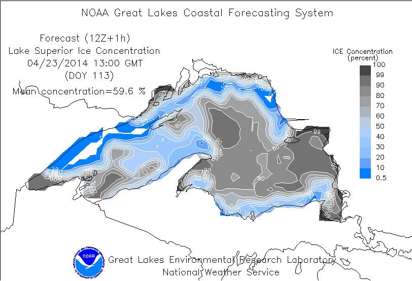
Lake Superior Ice
Lake Superior early this year saw a peak ice coverage near 95%, but is currently down to 59.6%. Here were some visible satellite images from just a few days ago to show you how much ice there still is on Lake Superior.
Tuesday, April 15th
Note that you can also see Lake Mille Lacs, Leech Lake and Lake Winnibigoshish are still ice covered.
Friday, April 18th
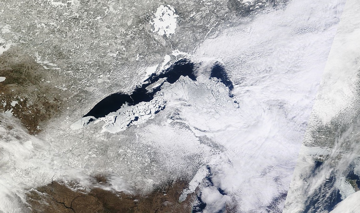
Wednesday, April 23rd
According to NOAA's GLERL, Lake Superior was still nearly 60% ice covered as of Wednesday, April 23rd. This is actually having an impact on the early shipping season...
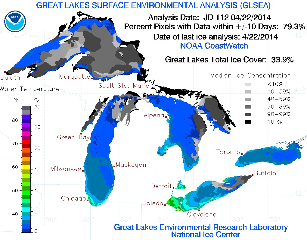
Great Lakes Ice
According to NOAA's GLERL, the Great Lakes were still nearly 34% ice covered as of Tuesday, April 22nd. Interestingly, this is nearly 20 times more ice than the long term average.
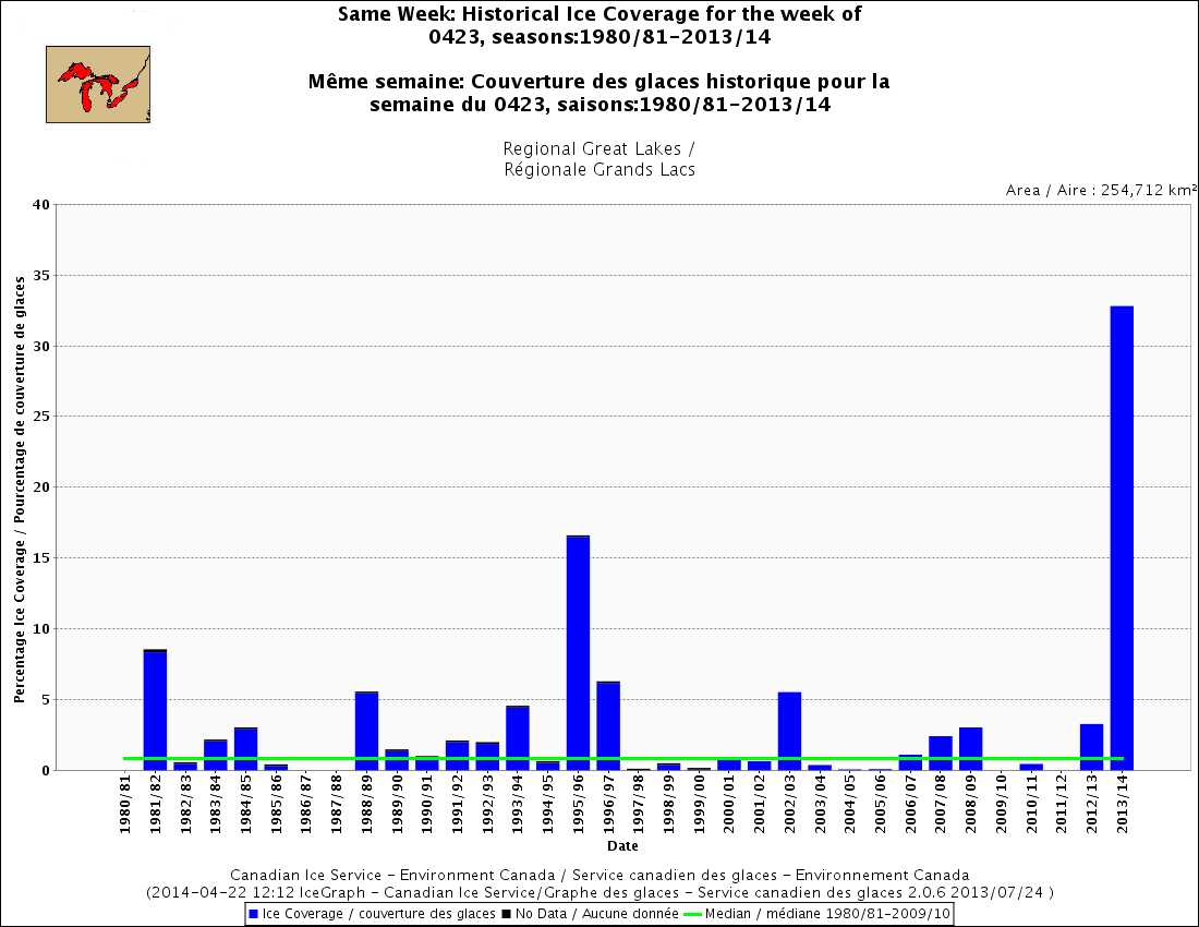
Record Levels of Great Lakes Ice?
The Capital Weather Gang has a nice, brief write-up about the recent high levels of Great Lakes ice this late in the season.
"It’s almost May and a third of the Great Lakes is still covered by ice. This is unprecedented in records dating back more than three decades, and it’s not even close.
Environment Canada’s Great Lakes ice dataset, which extends back to 1980-81, shows the current ice extent at a chart-topping 32.8 percent as of April 22. The year with the next greatest ice extent on this date, 1996, had about half as much ice – or 16.49 percent coverage. The average Great Lakes ice cover right now is 2.2 percent. There is roughly 16 times more ice than normal right now!"
See more from the WashingtonPost.com HERE:
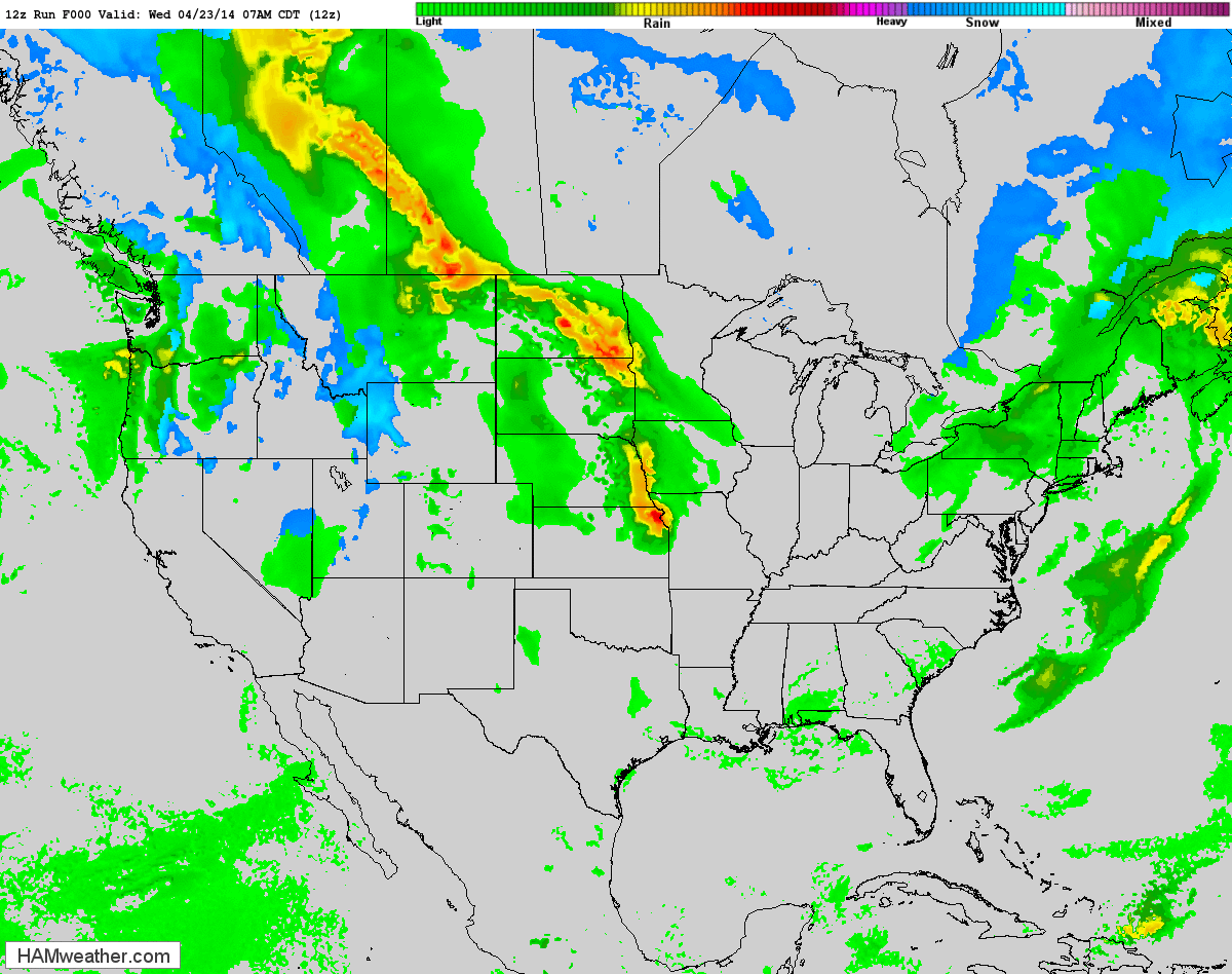
Active Weather Continues
The higher resolution model below shows our first strong storm system wrapping up across the middle part of the country through the second half of the work week, while another strong storm system moves into the West Coast.
Severe Threat Thursday
Our current storm system in the middle part of the country will kick out some strong to severe storms on Thursday across parts of the Mississippi River Valley. Hail and high winds look to be the primary threat, but an isolated tornado can't be ruled out.
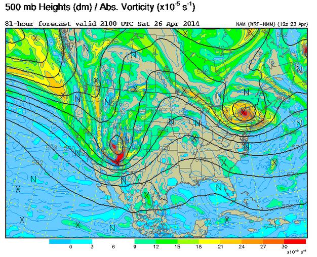
Strong Pacific Storm
The next storm that we will be watching will be the impulse of energy moving into the western part of the country by late week. The 500mb vorticity (spin) map, shows a fairly stout disturbance moving into the Southwest over the weekend. As this particular storm system works out into the Plains, strong to severe storms look to once again push across the middle part of the country.
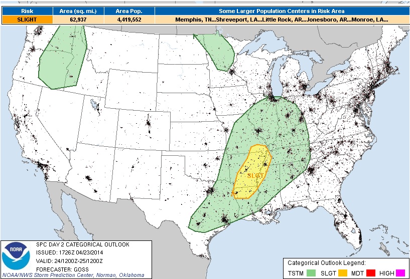
 Severe
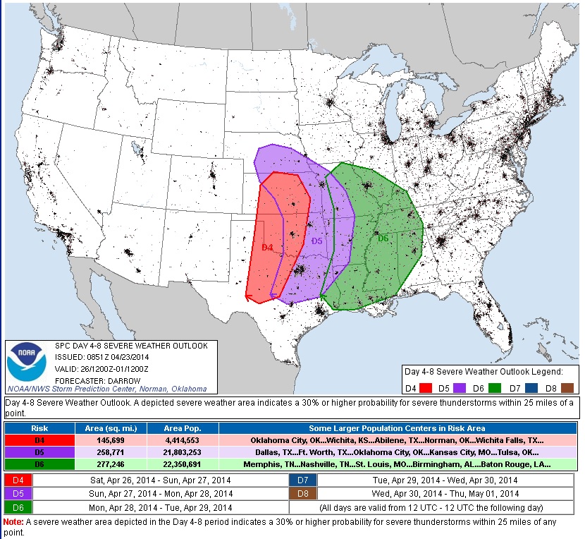
 Storms Ahead?
The Storm Prediction Center has already issued severe weather outlooks from Saturday through Monday for the areas below. The deepening area of low pressure looks to kick out a multi-day severe weather potential.
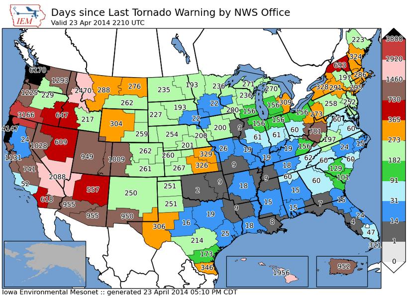
Days Since Last Tornado Warning
This is an interesting map that shows how many days it's been since we've seen a tornado warning in any particular National Weather Service county warning area. note that it has been nearly a year since we've seen a tornado warning in parts of eastern Kansas since the last tornado warning.
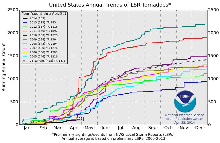
2014 Tornado Count
According to the Storm Prediction Center, the 2014 PRELIMINARY tornado count through April 22nd is at a very low 109 reports. The 2005-2013 average through April 22nd is 428 reports! In 2013 we saw just 223 reports through that date, while in 2008 there had been a whopping 643 reports through that date!
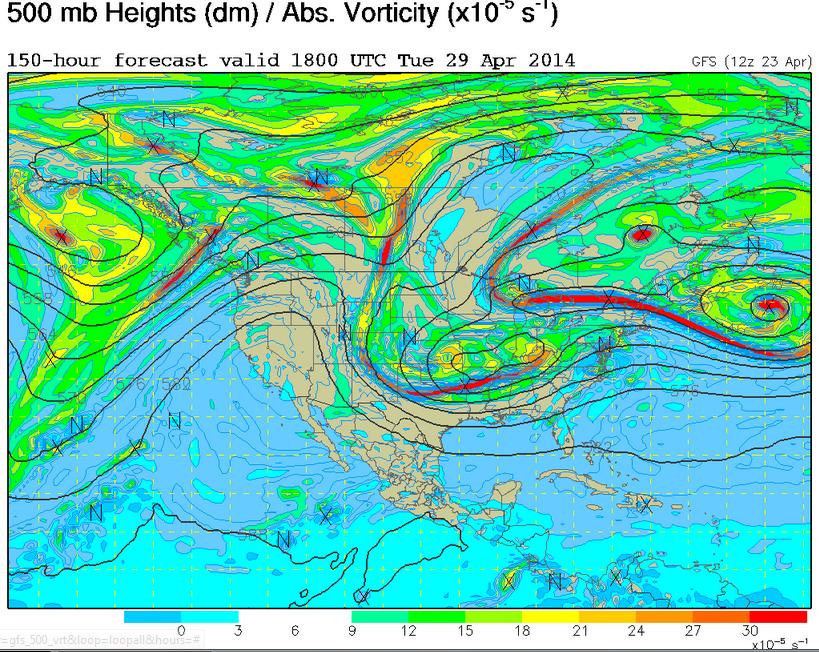
High Amplitude Weather Pattern
The strong storm that looks to kick out several days of strong to severe thunderstorms, looks to also nearly stall across the central/eastern part of the nation. The end result will be a just stream that will get all bent out of shape, this type of weather pattern is known as a High Amplitude weather pattern, which means that weather tends to get stuck... The image below shows the 500mb vorticity (spin) map for Tuesday, April 29th. Note how the lines bubble north in the western third of the country, while the lines dip south across the eastern two-thirds of the nation. This will dictate warming and cooling and it certainly looks warm/hot in the Southwest, while it appears to be quite chilly in the eastern two-thirds of the nation.
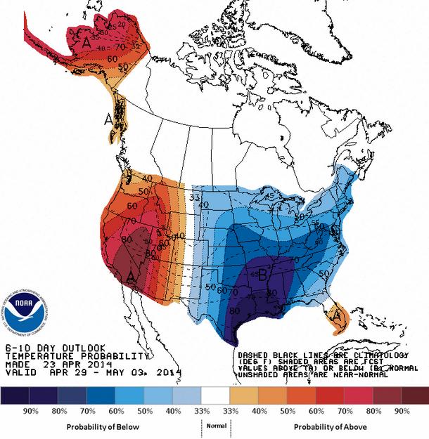
Temperature Outlook
Take a look at NOAA's HPC 6 to 10 day temperature outlook, which will take us into early May. Note that the temperature trends from April 29th to May 3rd mirror what the jet stream will look like next Tuesday, April 29th. Next week is going to feel very March-like...
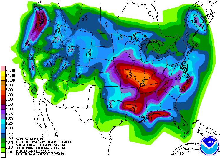
Precipitation Outlook
According to NOAA's 7 day precipitation outlook, it looks quite wet across much of the nation through early next week. As our 2 storm systems plow across the nation, heavy rainfall from convective type showers will likely several inches of precipitation in the central part of the country.
Thanks for checking in and have a great rest of your week! Don't forget to follow me on Twitter @TNelsonWNTV

No comments:
Post a Comment