82 F. high in the Twin Cities Tuesday.
80 F. average high on June 17.
82 F. high on June 17, 2013.
June 17 in Minnesota Weather History. Source: Twin Cities National Weather Service:
1850: Territorial Governor Ramsey reports that about halfway between Ft. Ripley and Ft. Snelling on the Mississippi a severe hail storm occurred in the evening. One or two hailstones picked up were as large as hens eggs and he thought he saw one about the size of a "musket ball."

We Surrender
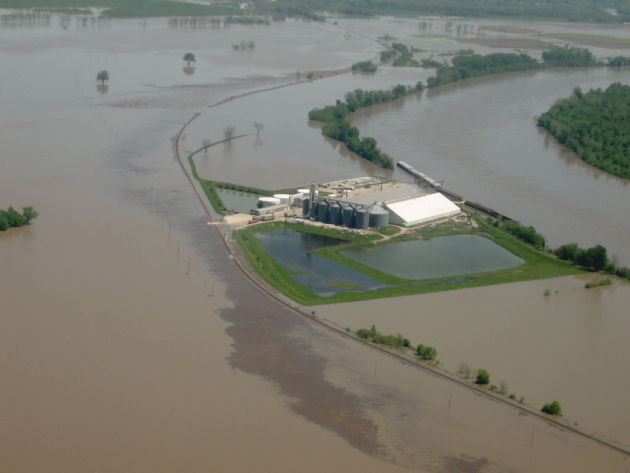
I've been standing by the Amish Doppler (window), waving the white flag of surrender, pleading for atmospheric mercy. Please stop the rain! Rivers are out of their banks, there's standing water in many fields across southern Minnesota and all-time rainfall records are falling.
Pete Boulay at the State Climate Office says it's the second wettest start to any year since 1871. As of Tuesday MSP was .12 inches from the all-time record in 2001. Dr. Mark Seeley reports "4 of the last 5 Junes (2010, 2011, 2013, and now 2014) have brought historically wet conditions to many parts of southern Minnesota".
The jet stream appears drunk; winds overhead light and sluggish - meandering unusually far south, prolonging T-storms capable of tropical rains into Thursday. Another inch or two of rain may fall before we dry out Friday and Saturday.
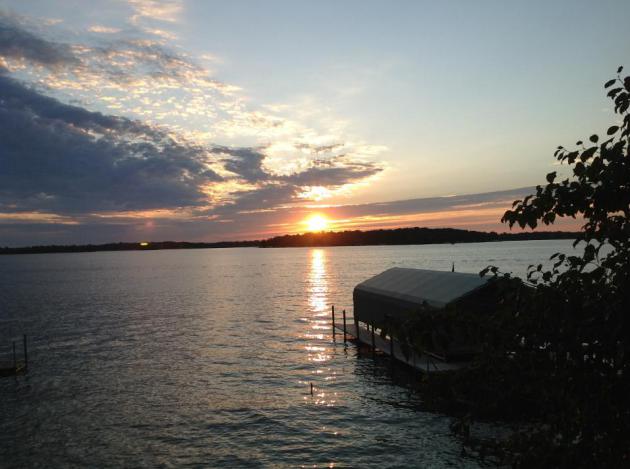
Dew points top 70F the next few days. Men will sweat, women will glow; overflowing lakes more inviting than ever.
The approach of drier, Canadian air sparks showers Sunday; nearly half as much water floating overhead by Tuesday as dew points drop back into the 50s. A dry, blue sky prevails much of next week with highs near 80F.
Yes, there is a light at the end of this super-saturated, jungle-like tunnel.
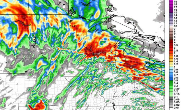
60 Hour WRF Rainfall Prediction.
Some 2-5" amounts are predicted by Friday morning over southeastern
Minnesota and southwest Wisconsin, aggravating an already-bad flash
flood scenario. Much of eastern and northeastern Minnesota may pick up
another 1-2" rain; Thursday still appears to be the wettest day of the
week. Map above: WeatherBell.
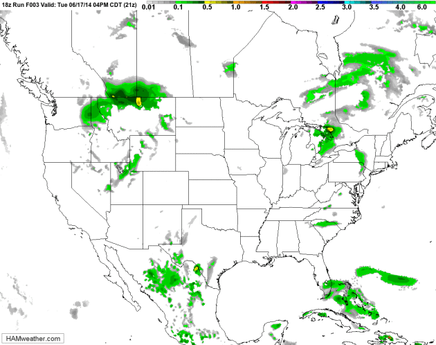
Light Steering Winds = Slow-Motion Weather Map.
Parts of Montana are digging out from a few inches of snow, just days
away from the Summer Solstice (which arrives early Saturday morning). A
frontal boundary limping eastward will focus showers and T-storms from
Montana and the Dakotas into the Upper Midwest late Wednesday and
Thursday, reaching the Great Lakes by Friday. Not a drop of rain in
sight for California and much of the west. 12 KM Future Radar from NOAA,
courtesy of HAMweather.
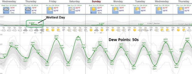
Serious Case of the Muggies - Breathing Easier Next Week.
If the sun stays out for a few hours today we should reach at least the
low 80s. Thursday looks a few degrees cooler with more clouds and more
numerous showers and T-storms. Once the front pushes east I expect
enough sun for highs in the mid, possibly the upper 80s Friday and
Saturday, before readings cool off next week. A dew point in the 50s by
Monday or Tuesday will mean roughly half as much water in the air as
today. Graph: Weatherspark.
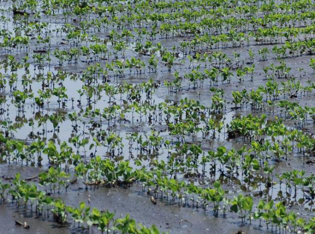
Soybean And Corn Seedling Diseases Increase With Flooded and Wet Soil Conditions. Thanks to Mark Seeley for passing this along, an excerpt from an update at University of Minnesota Extension: "...Infection
of seedlings before or after emergence can result in dead plants,
rotted and discolored roots, stunted and discolored plants, and wilting.
The problems often occur in patches in fields. Seedling infection can
also lead to damage that may not fully develop until mid to late summer,
as with Phytophthora root and stem rot and sudden death syndrome.
Disease can cause serious damage, but it is just one of many stresses
that seedlings are encountering. Careful scouting and diagnosis are
often required to identify the cause of a problem..." (Photo credit: D. Malvick).

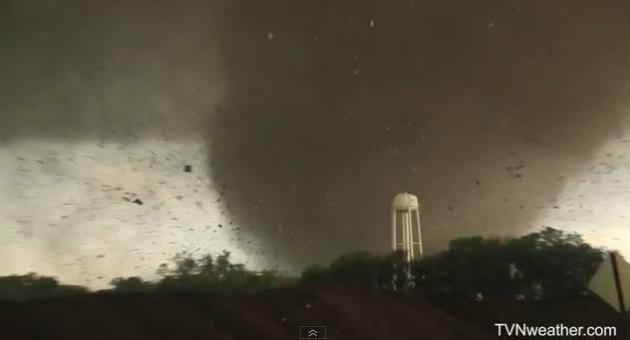
Remarkable YouTube Tornado Footage. Check out the incredible YouTube footage from the EF-4 Pilger, Nebraska tornado Tuesday evening, courtesy of TVNweather.com. Here's what they wrote: "Insane
video of violent tornado as it was about to hit Pilger, Nebraska. Then
had to abandon the chase for search and rescue. Damage appeared like
F4/F5 with bark stripped off trees and foundations wiped clean. Our
thoughts and prayers are with the residents of Pilger, NE."
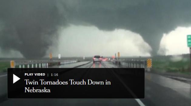
Double Tornado Batters Nebraska. The New York Times has a video recap of the twin tornadoes that leveled the town of Pilger, Nebraska late Tuesday; here's an excerpt that caught my eye: "...Monday’s
twisters hit the ground about one mile apart, which is not in itself
unusual, meteorologists said. What is rarer however, Pat Slattery, a
spokesman for the National Weather Service, said is that the tornadoes
appear to have been similar in size, though the wind speeds have not yet
been determined. “Twin tornadoes happen with some frequency, but
usually it is a large tornado with a smaller one accompanying it,” Mr.
Slattery said..."
How Did The Rare Twin Tornadoes in Nebraska Form? Gawker
has a very good explanation (with great graphical explainers) about the
tornadoes that struck Pilger, Nebraska; here's an excerpt: "...Well,
what happened yesterday is essentially a twister birth defect. We saw
two large, independent tornadoes form from the same thunderstorm and
track side-by-side for an exceptionally long time across northeastern
Nebraska. Meteorologists are going to study this storm for a long time,
and nobody has a definite answer as to exactly why it happened, but I
think I've developed a pretty reasonable explanation for it..."
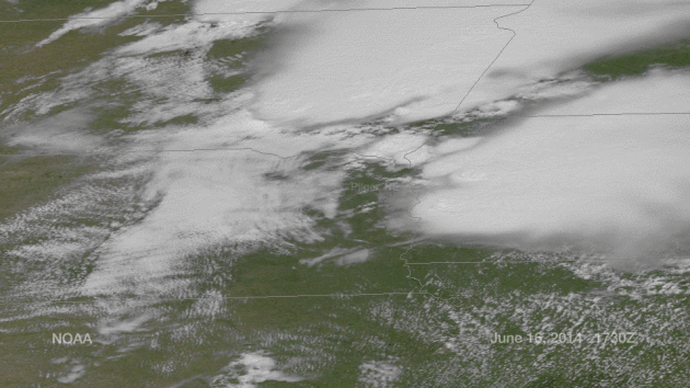
Pilger Tornado Outbreak from Space.
Here's a high-resolution visible satellite loop showing the supercell
thunderstorms that went on to spawn EF-4 tornadoes near Pilger and
Stanton, Nebraska, courtesy of NOAA.
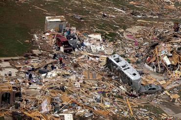
Photo credit above: "Researchers at the National Severe Storm Laboratory are working on project slated to be done 2020 that narrows in on the location a tornado can hit and gives people more notice before it strikes." (AP)
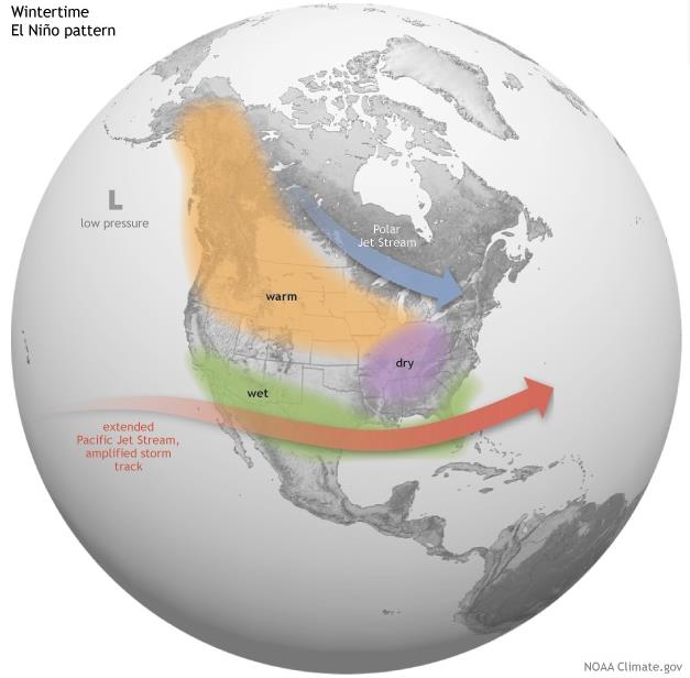
Graphic credit above: "Average
location of the Pacific and Polar Jet Streams and typical temperature
and precipitation impacts during the winter over North America." Map by Fiona Martin for NOAA Climate.gov.
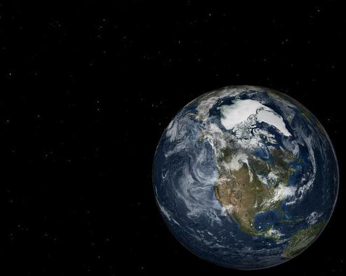
* Bloomberg reports on a possible easing or delay of El Nino.
El Nino Could Make U.S. Weather More Extreme in 2014. No kidding. Here's an excerpt from an article at Scientific American: "Unusual
weather across the U.S. and other parts of the world just became more
likely for this summer and autumn. That’s because the chances have gone
up that El Niño—an atmospheric pattern driven by water temperature
changes in the Pacific Ocean—will develop during that time, according to
the nation’s leading climate experts. When El Niño settles in, it has
major effects on weather conditions nationally and globally. Scientists
speaking at a press conference yesterday afternoon said the odds that El
Niño will develop during the summer have risen from 65 to 70 percent..."
Graphic above: NOAA's El Nino Page.
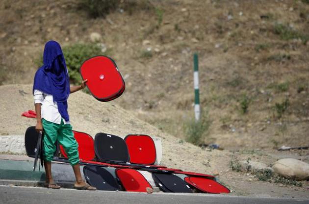
Anger Rises As India Swelters Under Record Heatwave. Details from Reuters and Lifescript.com: "Swaths
of north India are sweltering under the longest heatwave on record,
triggering widespread breakdowns in the supply of electricity and
increasingly angry protests over the government's failure to provide
people with basic services. The power crisis and heatwave, which some
activists say has caused dozens of deaths, is one of the first major
challenges for Prime Minister Narendra Modi, who was elected three weeks
ago partly on promises to provide reliable electricity supplies. In
Delhi, where temperatures have hit 45 Celsius (113 Fahrenheit) for six
days straight, residents marched through the streets in protests
organized by opposition parties on Thursday..."


10 Scientific Ideas That Scientists Wish You Would Stop Misusing.
A little knowledge goes a long way, especially when it comes to
hijacking and confusing scientific terminology. Here's an excerpt from a
valiant attempt to debunk some of the worst examples at io9.com: "...Mathematician Jordan Ellenberg wants to set the record straight about this idea:
"Statistically significant" is one of those phrases scientists would love to have a chance to take back and rename. "Significant" suggests importance; but the test of statistical significance, developed by the British statistician R.A. Fisher, doesn't measure the importance or size of an effect; only whether we are able to distinguish it, using our keenest statistical tools, from zero. "Statistically noticeable" or "Statistically discernable" would be much better.


It Would Cost $343,368 To Buy Every Product Featured In The Latest Issue of Vogue. In case you were wondering. Here's an excerpt from a story focused on the very definition of wretched excess from Quartz: "Like many of us, Noah Veltman found himself feeling uncomfortably covetous every time he read a glossy magazine. But
rather than forking out $695 for the Tom Ford swim trunks he saw
featured in GQ, Veltman, a journalist and developer at the New York City
public radio station WNYC, decided to parse the data. He hand-tallied
the quantities and prices of products featured on the editorial pages of
the June issues of 10 major magazines (plus the May 19 issue of New
York magazine). Here are his findings in four charts..."
TODAY: Some sticky sun, thunder possible by evening. Dew point: 71. Winds: E 10-20+ High: 86
WEDNESDAY NIGHT: Showers and T-storms, locally heavy rain. Low: 70
THURSDAY: More numerous T-storms. More flash flooding? High: near 80
FRIDAY: More sun, warm & dry. Wake-up: 68. High: 86
SATURDAY: Nicer day of the weekend? Plenty of sun. Lake-worthy. Wake-up: 62. High: 87
SUNDAY: Unsettled, few showers and T-showers. Wake-up: 65. High: 83
MONDAY: Some sun, less humid. Dew point: 60. Wake-up: 60. High: 78
TUESDAY: More sun. "Pleasant". Wake-up: 59. High: 80
Climate Stories...

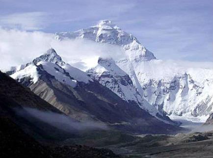
China Exclusive: Climate Change Thawing Tibet Plateau's Frozen Earth. Here's a clip from GlobalPost: "The
perennial frozen earth on China's Qinghai-Tibet Plateau has shrunk by
16 percent over the past three decades as a result of global warming,
according to new research results. The volume of frozen earth on the
plateau has decreased from 1.5 million to 1.26 million square km,
researchers with the Chinese Academy of Sciences (CAS) found after
decades of study using remote sensing and satellite monitoring. The
thawing of the frozen earth is an immediate result of global warming, as
the Qinghai-Tibet Plateau, at an average altitude of 4,500 meters, is
extremely vulnerable to climate change, said a research paper published
by the CAS Institute of Tibetan Plateau Research and seen by Xinhua on
Monday..."
No comments:
Post a Comment