81 F. high in the Twin Cities Wednesday.
80 F. average high for June 18.
75 F. high on June 18, 2013.
.51" rain fell yesterday at KMSP.
21.10" precipitation in 2014, as of Wednesday evening. That means 2014 is the wettest year, to date, since records were first kept in 1871.
20.70" previous record rainfall from January 1 to June 16 (2001).
Trending Wetter?
Wanted:
young inventors creating strains of corn that can grow in standing
water - new varieties of trees able to withstand severe winds &
soggy soil - and more resilient highway materials to deal with
temperature extremes and water drainage. A wetter, more volatile climate
is a threat, and an opportunity for reinvention.
20 years ago
climate models predicted wet areas would get wetter - dry areas would
get drier. Call me crazy but that's pretty much what we're seeing on our
maps.
Dr. Mark Seeley confirms 4 of the last 5 Junes have seen
historically wet conditions over southern Minnesota. The Minnesota
Climate Office lists four separate 1-in-1000 year flood events since
2004; 3 of them in southern Minnesota.
Coincidence - or a trend in the making? We'll see.
A
slow-moving frontal boundary whips up more showers and heavy T-storms
today; more flash flooding is possible, especially over far southern
Minnesota. Warm sun Friday & Saturday gives way to a few T-showers
Sunday as Canadian air starts to push south.
I see drier, cooler
weather next week with a welcome dip in dew point. We may go 3-4 days
with no rain, giving fields a chance to drain, river and lake water
levels may recede a bit. At least we won't have a drought. And it's not
snowing.
Whew...
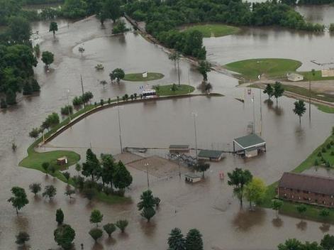
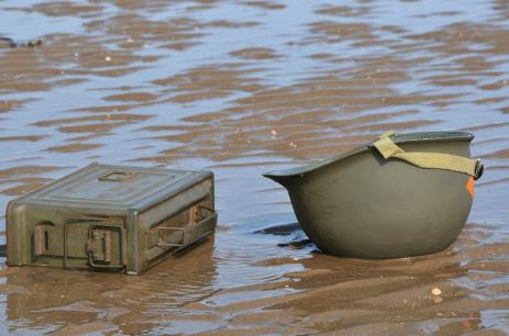
Flooding Swamps Mankato; 100K Acres of Crops Lost in Rock County. Here's an excerpt from
The Star Tribune: "...
The
road closures resulted from heavy rain that fell shortly after midnight
in Mankato and nearby areas, according to the National Weather Service
(NWS). The storm also brought hail with it, the NWS added. “We’ve just
gotten so much rain in the past couple of weeks that the soil’s had all
it can take; the wetlands are soaking up as much as they can; the
streams and lakes are running high,” said Craig Schmidt, service
hydrologist for the National Weather Service. “A lot of our lakes have
hit record or near-record levels. Everything’s high, and there’s just no
place for the water to go...”
Photo credit above: Glen Stubbe, Star Tribune. "Paul
Zimmer kept watch over the rising Minnesota River from the closed Land
of Memories Park in Mankato on Wednesday, June 18, 2014. The park at the
confluence of the Minnesota and Blue Earth rivers is also the location
of three of Mankato's fresh water wells. Zimmer is the water treatment
plant maintenance foreman for Mankato."
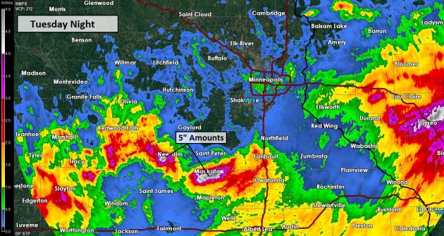
Blue Earth County Impacted By Heavy Rainfall. Some extreme rainfall amounts were reported Tuesday night in the Mankato area; here's an excerpt of a report from
Blue Earth County: "
Between
4 to 6 inches of rain was reported in Blue Earth County overnight
resulting in several road closures and impacts due to the heavy rainfall
throughout rural areas and communities. Many homes are experiencing wet
basements from the large amounts of rainfall, trees are down in a
number of areas due to the unstable soil from the accumulation of many
days of rain and river levels continue to rise. Northern portions of
Blue Earth County have been impacted the most, including City of Mankato
proper and Madison Lake..."
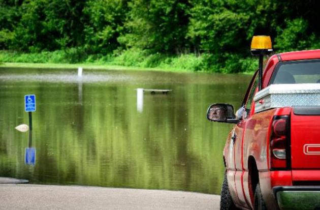
Minnesota's Current Weather Disaster - Don't Worry, We'll Be Fine.
It's certainly a slow-motion disaster for farmers and homeowners
experiencing flooded homes and basements. Minnesota science writer Greg
Laden has a post detailing his personal experiences with the record
rains, listing some of the wet weather headlines of recent weeks. Here's
an excerpt of his post at
scienceblogs.com: "...
One
day in late May, Julia and I were taking pictures of people driving too
fast through the lake that formed in front of our house form a major
downpour. Early in that storm we witnessed a ground strike not too far
away. A short while after that an ambulance came screaming by our house,
coming from the direction of the ground strike to the hospital just
south of us. Later we heard on the news that a woman at a little league
game (which, frankly, should have been cancelled) was struck and
transported to the hospital … that was certainly her. This morning,
Mankato was flooded, a day or two ago a woman was rescued from her car
that was eventually swept away by a river that does not normally exit.
Flooding up on the Canadian Border has been epic. The entire state is
under a Meteorological Siege..."
* more details on flooding across Minnesota, South Dakota and Iowa at
floodlist.com.
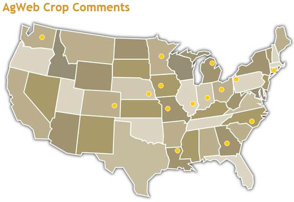
Mission Impossible for Area Farmers. I often check out
AgWeb.com
to see what farmers are saying about growing conditions around the
country; here's a recent excerpt describing how wet weather is impacting
operations:
- 6/17 - Sibley County, Minn.: All
the good to excellent corn must be elsewhere than in this county. Many
fields still not touched due to wetness, corn small and yellow due to
oversaturation. I expect some big surprises on actual acres planted and
the actual yields we are a long way from being in the bin with this
"huge" corn crop, odds are it wont be huge in Sibley County....
- 6/17 - South Central Minn.: Corn
Flat to the ground after last nights storm. Streak of Hail on some to
our west. Many Acres under water. Corn was already yellow and uneven.
Predicting severe storms every day this week. We don’t get record crops
in this part of the country when it rains like this.
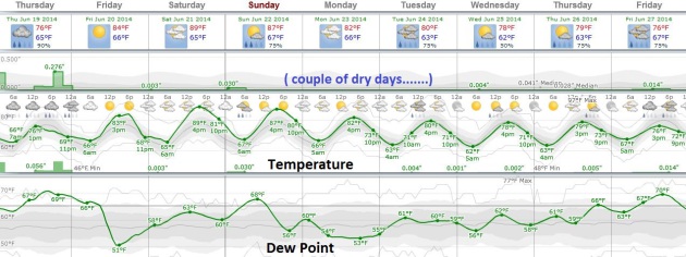
Slight Cooler and Drier Next Week.
Long range guidance continues to show a slight dip in dew point next
week with highs in the upper 70s to near 80. Today still looks like the
wettest day, followed by a drier sky Friday and Saturday; a slight
chance of another T-shower Saturday into Sunday. We may even experience a
few dry days in a row early next week. That would be nice. Graphic:
Weatherspark.
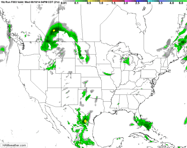
Tropical.
A slow-moving frontal boundary pushes heavy showers and T-storms across
the Upper Midwest today, reaching the Great Lakes and New England by
late week. A few pop-up storms may help to break the heat from the Mid
Atlantic to the Ohio Valley over the next 72 hours. NAM Future Radar:
NOAA and HAMweather.
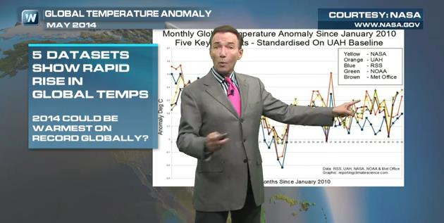
It's Not The Heat - It's The Humidity.
Yes, grandma was right about that one. When there's this much water in
the air your body can't effectively cool itself naturally via
evaporation of sweat off your skin - and it's much easier to overheat.
In today's
Climate Matters
I take a look at the dreaded Heat Index, a look at what NASA is
tentatively calling the warmest May - worldwide - on record, JMA
believes spring was the warmest on a global scale, and at the rate we're
going 2014 may rival 2010 as the warmest year ever recorded, with or
without El Nino.
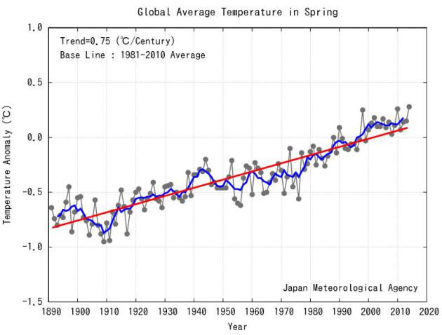
Warmest Spring on Record, Worldwide. Here's an excerpt from a post by the JMA,
Japan Meteorological Agency: "
The
seasonal anomaly of the global average surface temperature in Spring
(March to May) 2014 (i.e. the average of the near-surface air
temperature over land and the SST) was +0.28°C above the 1981-2010
average (+0.69°C above the 20th century average), and was the warmest
since 1891. On a longer time scale, global average surface temperatures
have risen at a rate of about 0.75°C per century..."
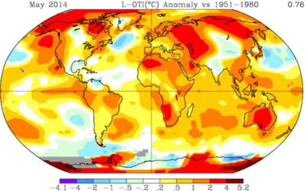
NASA May Anomaly Hints 2014 Will Be Hottest Year On Record.
Even without El Nino kicking in fully temperatures are running well
above average, worldwide, for 2014 to date, and at the rate we're going
NASA believe we may set another global temperature record. Here's a clip
from
InsideClimate News: "
Global
average surface temperatures could be on track to chalk up a new record
in 2014 if the trend set in the first five months of this year
continues. Data released today by US agency NASA shows that May's global
temperature anomaly – the variance with the long term average - was
0.76 C. This compares with the previous warmest Mays in 2010 (0.70 C) and in 1998 (0.68 C) - an El Nino year..."
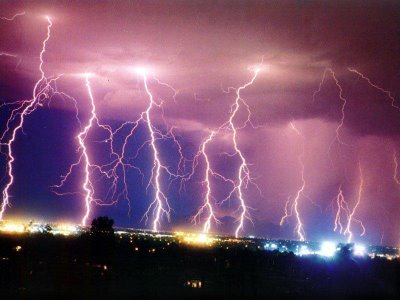
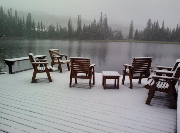
Atmospheric Cry For Help.
Record heat from the Mid Atlantic into the Ohio Valley, while residents
of Big Sky, Montana dig out from a few inches of....snow? Thanks to
Ethan Mark Thomas for sending this one in. This is the very definition
of a baffling weather pattern.
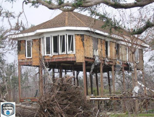
Hurricane Danger Zone: The 10 Places Most At Risk. It's a bit counterintuitive, but this article at
USA TODAY points out that some of the most vulnerable counties are inland; here's a clip: "...
Surprisingly,
the "top 10" counties are not along the coast, and many are actually
well inland. This is because the people who live near the coast tend to
be wealthier and are better able to prepare for the storms, Schroeder
said. Inland counties in Florida, Mississippi and Louisiana were areas
that were most concerning...
The top 10 counties most vulnerable to hurricanes:
Desoto, Fla.
Houston (County), Texas
Polk, Texas
Issaquena, Miss...."
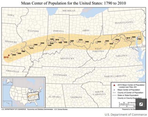
21 Charts That Explain How The U.S. Is Changing. I found this graphical essay from
Vox
fascinating - here's an excerpt: "...One way the Census Bureau measures
geographic shifts is by measuring the US's "mean center of population" —
that is, "
the place where an imaginary, flat, weightless and rigid
map of the United States would balance perfectly" if all Americans
weighed exactly the same. As of 2010, that point was near the village of
Plato, Missouri. But this westward and southward doesn't necessarily
mean that lots of Americans are packing up and moving west and
south...rather, it simply means that the populations of the West and
South keep growing faster than the Northeast and Midwest..."
Let's All Stop Saying "Disrupt" Right This Instant. Are you working on something "disruptive"? Are you sure? Here's a clip from a good story at
New York Magazine: "...
"Disruptive" doesn't
mean "inventive," "unorthodox," or "cool." It has a specific, concrete
definition that originated with Harvard Business School professor
Clayton Christensen's 1995 paper, "Disruptive Technologies: Catching the Wave,”
and his 1997 book, The Innovator's Dilemma. Christensen defined
"disruptive innovation" as the process by which "technologically
straightfoward" services and products target the bottom end of an
established market, then move their way up the chain until, eventually,
they overtake the existing market leaders..."
The New Jet Age.
Vanity Fair has a story and video on what may be the world's most amazing airport, Dubai International. Here's an excerpt: "...
In
January 2013, Dubai International opened Concourse A—aviation’s first
facility dedicated entirely to Airbus A380 superjumbos. Located in
Terminal 3, it is a magnificent building. Huge first- and business-class
lounges connect directly to the A380 upper decks; economy-class
passengers board from the lower level. The new concourse has already
increased Dubai’s traffic to 75 million passengers a year, moving it
past London’s Heathrow as the world’s busiest international airport. By
2018 that number is expected to pass 90 million, overtaking vast
domestic hubs such as Atlanta and Beijing..."
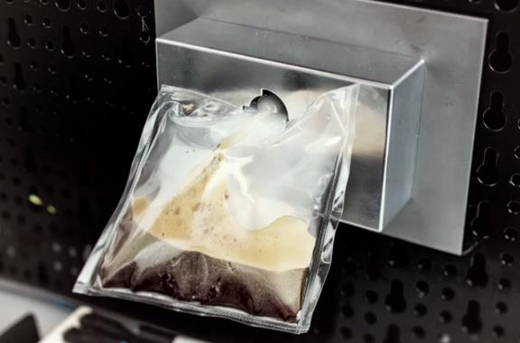
Expresso in Space? Yes, decent coffee is coming to the ISS, the International Space Station. Here's an excerpt from
Salon: "
Last year Italian astronaut Luca Partmitano took questions from Astronaut Abby about
his stint on the International Space Station. When asked what food he
wished were available on the ISS, Partmitano responded: “The only thing I
really miss, if we talk about food, is a real Italian espresso.” In
November, the treat of hot espresso will be available for astronauts on
the International Space Station..."
Photo credit:
ISSpresso (Credit: screenshot)
TODAY: Unsettled and muggy with showers & T-storms. A few downpours. Dew point: 69. Winds: SE 10. High: near 80
THURSDAY NIGHT: More T-storms in the area, locally heavy rain possible. Low: 68
FRIDAY: Sunnier. Drier. Warmer. High: 86
SATURDAY: Nicer day of the weekend. Warm sunshine. Wake-up: 67. High: 88
SUNDAY: Some sun, risk of a T-shower. Wake-up: 71. High: 84
MONDAY: Partly sunny, probably dry. Wake-up: 69. High: 81
TUESDAY: More clouds than sun. Wake-up: 65. High: near 80
WEDNESDAY: Intervals of sun, less humidity. Dew point: 56 Wake-up: 63. High: 78
Climate Stories...
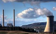
Global Warming Will Bring Electricity Sticker Shock, EIA Suggests. Good news for utilities and their shareholders? Perhaps, assuming the grid stays up. Here's a clip from a story at
TheStreet: "...
Similarly,
if the coming summer follows the recent trend, temperatures will be
uncomfortably warm. The National Oceanic and Atmospheric Association
reports April of this year tied with April of 2010 for the warmest on
record globally. The EIA is forecasting that, even as prices have risen a
relatively modest 2.6% on average the average each year since 2012,
U.S. residential electricity customer will spend 4.9% more during the
coming summer thanks to increased temperatures and higher expected
consumption. The Northeast will be especially hard hit..."
Climate Change Worries Insurance Companies and our Military. Here's an excerpt from
Living Green Magazine: "
Powerful
voices in finance and the armed forces raise concerns about the risks
of increasingly extreme weather events causing billions of dollars of
damage and potentially igniting humanitarian disasters and regional
conflicts. The risks associated with climate change
have got some very important people worried – the people who pick up
the bills, and those who clear up the mess or try to prevent it
happening. The world s biggest and oldest insurance market, Lloyd’s of London,
has published a report that urges insurers to include climate risks in
their models. It says: Scientific research points conclusively to the
existence of climate change driven by human activity..."
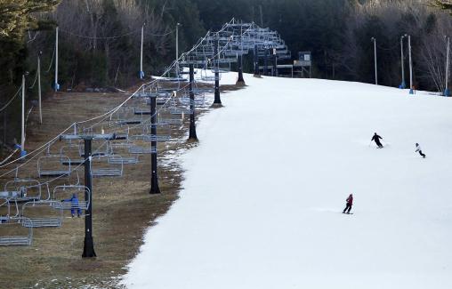
Climate Change Threatens Tourism as Ski Slopes Thaw, Seas Rise.
Reuters has the story - here's an excerpt: "...
It
also said that an increase of 1 meter (3 feet) in sea level rise this
century - the upper bound of scenarios by the U.N. panel - would damage
up to 60 percent of resort properties in the Caribbean and swamp many
airports and ports. "Every part
of the industry needs to ... think about what more can be done to adapt
to climate change, as well as how to continue the process of reducing
the impact of their operations on the environment," Stephen Farrant,
director of the International Tourism Partnership, said in a statement
attached to the report..." (File photo: AP).
Should Climate Change Come With A Warning Label? National Journal has the story of what's happening in Berkeley, California. Here's an excerpt: "
We
already require cigarette packs to include warning labels," Matthew
Lewis, the co-chair of the Chancellor's Advisory Committee on
Sustainability at Berkeley told the Daily Californian earlier
this week. "Requiring labels at gas pumps would similarly keep the harm
of burning gasoline fresh in people's minds." Berkeley's Community
Environmental Advisory Commission approved the plan Thursday. The
proposal now awaits a City Council vote, which is expected to take place
in the next few weeks..."


No comments:
Post a Comment