72 F. high in the Twin Cities Wednesday.
82 F. average high on June 25.
84 F. high on June 25, 2013.
.35" predicted for MSP by Monday (00z NAM model).
2.1" rain predicted by Monday (12z ECMWF).
1.73" rain predicted next 16 days (18z GFS model).
High Bust Potential
Meteorologists
are risk-adverse; we deal in statistics, percentages and probabilities.
We don't like to talk about errors, goofs or blunders. It's impolite.
Instead we fixate on "busted forecasts" and try to learn from our (very
public) mistakes.
When I travel east I'm still reminded of a
tragically bone-headed 4th of July forecast...in 1976. I predicted
drizzle. It POURED for 8 hours. Some people never forgot.
The next
1-2 weeks is, for many, the highlight of summer. Friends & family
gathered at the lake - dinners, picnics and outdoor wish lists, all at
the mercy of Mother Nature.
Yes, we're nervous, and for good reason.
2014:
wettest year, to date - and probably the wettest June since 1871 at the
rate we're going, with more T-storms in the forecast Friday into
Sunday, as yet another sloppy front runs out of gas directly overhead. I
don't think we'll see a rerun of last Thursday's tropical monsoon, but
some 1-2 inch amounts are possible with these T-storms. Some additional
flooding is possible.
Cooler, drier, Canadian air presses
south next week with 70s by midweek. ECMWF data hints at 80F on the 4th
with some sun. What can go wrong?
Light a candle. Hope for the best.
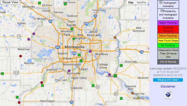
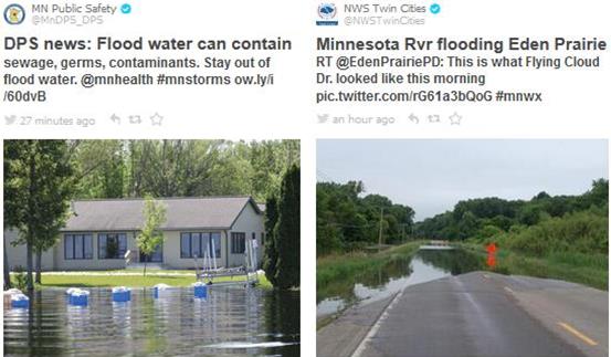
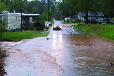
River Flooding Update.
The Mississippi River in St. Paul should crest today, all other rivers
and streams in the metro area have crested with water levels falling
over time. More torrential rains over the weekend could cause streams
and rivers to rise again next week, but the extent of any additional
rises will depend on rainfall amounts this upcoming weekend. An
interactive map from NOAA is
here.
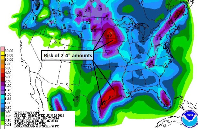
Not What The Weather Doctor Ordered.
Stating the obvious: Minnesota and the Upper Midwest doesn't need more
torrential rains, coming off record June rains and the wettest year, to
date, for much of the Upper Mississippi Valley. But NOAA guidance is
showing some 1-2" amounts likely, with a significant risk of (isolated)
3-4" amounts from repeated outbreaks of T-storms Friday into Sunday.
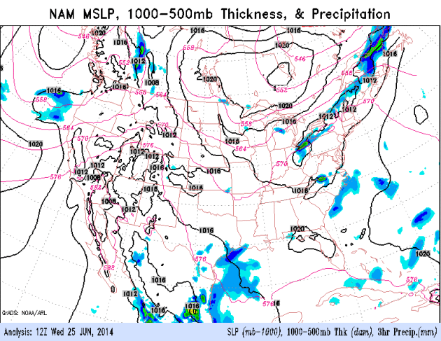
Another Slow-Motion Frontal Passage.
Everything usually slows down during the summer months; storms and
frontal boundaries tend to limp across the Lower 48 at 10-15 mph as main
steering winds lift north into Canada. But this year we're seeing a
perpetual holding pattern: a heat-pump high accelerating record heat and
drought for California and much of the southwestern USA, while east of
the Rockies a series of sloppy fronts meander east, fueled by a
persistent tropical flow from the Gulf of Mexico. NOAA's NAM model
(Future Radar) shows heavy showers and T-storms from Texas to Minnesota,
a bubble of Canadian high pressure treating New England to cool, dry
weather.
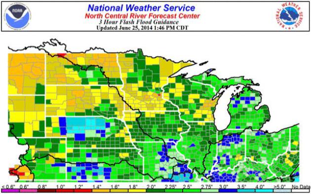
Flash Flood Guidance.
The map above from NOAA shows the amount of rain necessary over a
3-hour period to reinitiate flash flooding: as little as 1" for Ramsey
county, 1.4" for Hennepin county - but less than 2" for most of southern
Minnesota where soils are soaked from recent rains. Some of the storms
Friday into Sunday may produce storms capable of 2-3" of rain over a
short period of time, complicating and extending our flood scenario into
early next week.
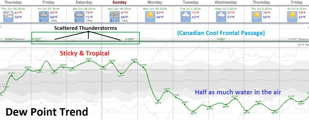
Tropical, Thundery Weekend - Hints of September Next Week.
Dew points approach 70F over the weekend as moisture from the Gulf of
Mexico continues to fuel a slow-moving frontal boundary; scattered
T-storms (some packing more downpours) from Friday into at least Sunday.
We dry out Monday and a stronger push of Canadian air treats us to dew
points in the 40s and low 50s by the middle of next week, roughly half
as much water in the air by Tuesday and Wednesday. Right now long-range
guidance hints at mid to upper 70s and relatively comfortable humidity
levels for the 4th of July. Fingers crossed.
 Lightning Science: 5 Ways Lightning Strikes People
. This is Lightning Safety Awareness Week in the USA, and I found this resource from
NOAA timely, considering that lightning-related injury and death peaks in June and July, nationwide. Here's an excerpt: "...
When
lightning strikes a tree or other object, much of the energy travels
outward from the strike in and along the ground surface. This is known
as the ground current. Anyone outside near a lightning strike is
potentially a victim of ground current. In addition, ground current can
travels in garage floors with conductive materials. Because the ground
current affects a much larger area than the other causes of lightning
casualties, the ground current causes the most lightning deaths and
injuries. Ground current also kills many farm animals. Typically, the
lightning enters the body at the contact point closest to the lightning
strike, travels through the cardiovascular and/or nervous systems, and
exits the body at the contact point farthest from the lightning. The
greater the distance between contact points, the greater the potential
for death or serious injury. Because large farm animals have a
relatively large body-span, ground current from a nearby lightning
strike is often fatal to livestock..."
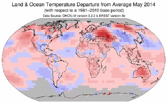
Temperature Highest On Record For May. Here's a clip from an update at
The Boston Globe: "
Driven
by exceptionally warm ocean waters, Earth smashed a record for heat in
May and is expected to keep on breaking high temperature marks, experts
say. The National Oceanic and Atmospheric Administration Monday said
May’s average temperature on Earth of 59.93 degrees beat the record set
four years ago. In April, the globe tied the 2010 record for that month.
Records go back to 1880..." (Map: NOAA NCDC).
* May was the 351st month in a row of global temperatures warmer than the 20th century average.
* More details on a toasty May around the world at
Quartz.
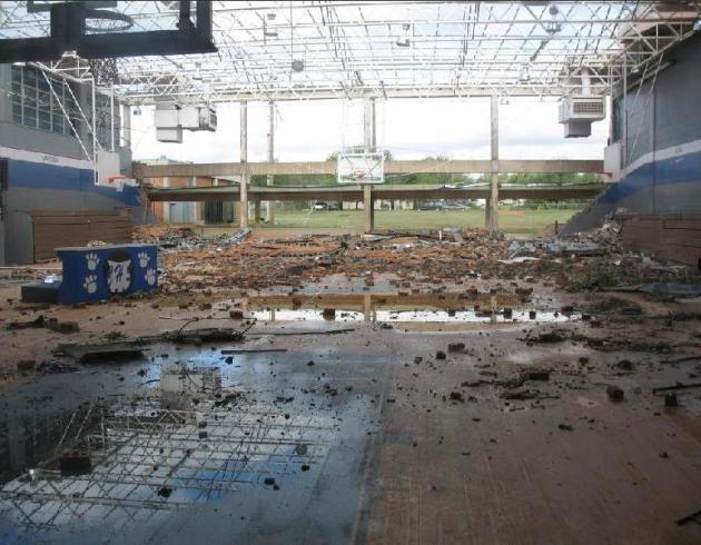
Schools Need Better Tornado Protection. No kidding. And putting kids in hallways may not be the safest option, it turns out. Here's an excerpt of a timely post at
LiveScience: "...
Despite
this danger, building codes are not designed to ensure that schools
withstand the kinds of winds even the most modest tornado can muster.
The standard is to build schools to resist 90-mph (145 km/h),
straight-line winds. The weakest EF1 tornadoes
can sustain gusts of up to 110 mph (177 km/h), and their rotational
winds put more pressure on buildings than a straight-line wind of the
same speed, Iowa State University engineer Partha Sarkar told Live Science in 2013. "The buildings are simply not designed to withstand that level of wind," Sarkar said..."
Photo credit above: Lubbock National Weather Service. "A May 2006 tornado damaged the gym of Childress High School in Texas."
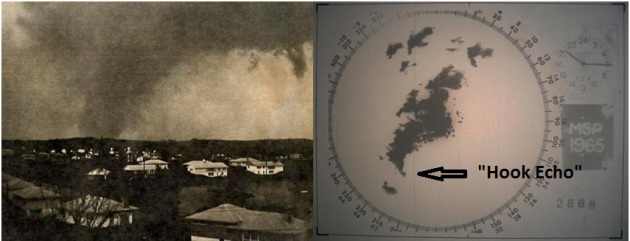
History of Tornado Forecasting.
Did you know that the word "tornado" was banned for the longest time,
for fear of inciting mass public panic? That's one of many interesting
nuggets from this worthwhile post from
NOAA; here's an excerpt: "...
In
1882, after nearly 300 years of numerous observations and stories of
whirlwinds, cyclones, and tornadoes, U.S. Army Signal Corps Sergeant
John P. Finley was placed in charge of the investigation of tornadoes
and the development of forecasting methods. During a tornado outbreak
that occurred on February 19, 1884, Finley established 15 rules
for early tornado forecasting. In 1888, Finley published these rules,
which identified signs that the formation of a tornado was likely.
Unfortunately, as Finley was developing his techniques, the tornado
prediction program encountered a huge road block. The word "tornado" was
banned from official forecasts by the U.S. Army Signal Corps due to
limitations with the observing network and concerns over causing mass
panic among the general public..."
* more detail on the history of tornado forecasting and the banning of the word "tornado" from
CNN.
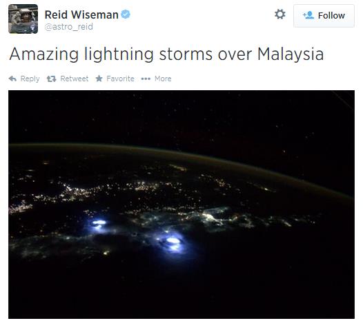
Gigantic Sprites over the USA.
Spaceweather.com
has an interesting story and video highlighting a recent spate of
"sprites", high-altitude lightning strikes that go straight up, observed
over Oklahoma. Here's a clip: "...
Here is one of the largest'
'jellyfish' sprites I have captured in the last four years." The cluster
shot up from western Oklahoma on June 23, so large that it was visible
from Ashcraft's observatory in New Mexico 289 miles away. "According to
my measurements, it was 40 miles tall and 46 miles wide. This sprite
would dwarf Mt. Everest!" he exclaims..."
ESA Sets Its Sights On Harpooning Space Debris. This article at
Gizmag caught my eye - here's an excerpt: "
In 2021, as part of its Clean Space Initiative, ESA plans to launch the e.DeOrbit mission.
The aim of this mission is to clean up the important polar orbits
between altitudes of 800 to 1,000 km (500 to 625 mil) that face the
prospect of becoming unusable due to the increasing buildup of space debris.
The ESA has now announced plans to examine the potential for the
mission to use space harpoons to capture large items, such as derelict
satellites and the upper stages of rockets..."
5 Ways Weather Is Pivotal In A Baseball Game.
All other things being equal, batters stand a better chance of hitting a
home run on a hot, muggy day with high dew points, when air density is
lower and the ball can travel farther.
AccuWeather has an interesting story - here's the intro: "
The
impact of weather on a baseball game may not always be immediately
recognizable as a heavy storm causing a rain-out, but it can be profound
even on a bright, sunny day. "The weather can impact every aspect of
the game," said Mike Collins, head baseball coach at Bloomsburg
University in Bloomsburg, Pennsylvania. Baseball is a sport that is
played throughout multiple seasons, so players must continuously adapt
throughout the year. Below are five ways weather can affect the outcome
of a game..."
North Korea Calls Seth Rogan - James Franco Film an "Act of War". Just when you thought things couldn't get any crazier in the Hermit Kingdom along comes this headline from
Huffington Post; here's a clip: "...
Could
Seth Rogen and James Franco trigger a conflict with North Korea? That's
what Pyongyang says, calling the duo's upcoming film an "act of war."
In "The Interview," starring Franco as a TV host and Rogen as his
producer, the two are sent to North Korea to assassinate supreme leader
Kim Jong Un. "The act of making and screening such a movie that portrays
the attack on our top leadership... is a most wanton act of terror and act of war, and is absolutely intolerable,"
a foreign ministry spokesman said in a statement cited by AFP. He also
threatened a "resolute and merciless response" if the film is not banned
by the U.S. government..."
Assorted Outrageous Superstar Tour Demands.
You may not quite believe what various stars and would-be divas demand
when they go on tour. Here's an excerpt of some of their demands at
Huffington Post, including some of the requests from musical artist Drake:
- 4 dozen natural scented incense sticks
- E-Z Wider rolling papers
- One
bottle of Pinot Grigio, one case of Heineken, one bottle of Jack
Daniel’s, one bottle of Patron Silver tequila, one bottle of Grey Goose,
and one bottle of Hennessy or Courvoisier..."
TODAY: More clouds than sun, a bit milder. Winds: SE 10. High: 79
THURSDAY NIGHT: Mostly cloudy, risk of a T-storm. Low: 66
FRIDAY: Scattered T-storms, few downpours - heaviest rains north of MSP. High: 84
SATURDAY: Sticky with lot's of clouds, a few heavy T-storms. S 15. Wake-up: 70. High: 82
SUNDAY: A bit drier with more sun. Lingering T-storm risk. Wake-up: 72. High: 86
MONDAY: Warm sun, breezy - drying out. Wake-up: 70. High: 85
TUESDAY: Partly sunny, cool breeze. Dew point: 54. Wake-up: 63. High: 76
WEDNESDAY: Plenty of sun, comfortably cool. Wake-up: 59. High: 74
Climate Stories...
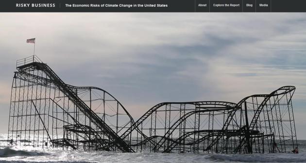
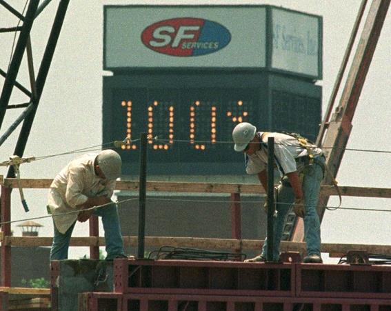
Climate Change Poses "Severe Health Risk" To Outdoor Workers.
The number of hot, humid, potentially dangerous days is expected to
rise, posing considerable additional risk to people who work outside on a
routine basis. That's one of many findings in the "Risky Business"
report, focused on potential economic impacts; here's an excerpt from
The Atlantic: "...
The report, Risky Business, was released today at an event in New York. It outlines all the ways that climate change threatens the U.S. economy, including a county-level analysis. Among its many findings:
- Over
the next four decades, the U.S. could lose between $66 billion and $106
billion worth of coastal property to rising waters. By the turn of the
next century, between $238 billion to $507 billion worth of property
could be under water. The losses will be predominantly along the Gulf
and Atlantic coasts.
- By 2050, "the average American will likely see 27 to 50 days over 95°F each year..."
Photo credit above: "
Construction workers in Little Rock during the 1998 heat wave." (Reuters)
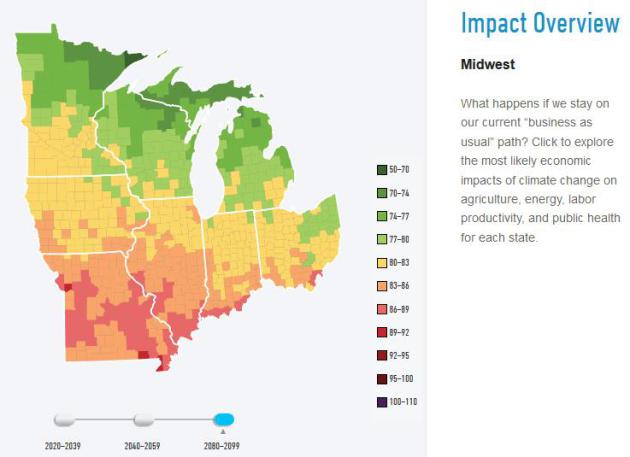
Risky Business - Key Predictions for Midwest. Here
is an excerpt of the recent, bipartisan study on future business and
economic impacts of rising seas and increasing climate volatility in the
Risky Business report: "...
Armed with the right information,
Midwest farmers can, and will, mitigate some of these impacts through
double-and triple-cropping, seed modification, crop switching and other
adaptive practices. In many cases, crop production will likely shift
from the Midwest to the Upper Great Plains, Northwest, and Canada,
helping to keep the U.S. and global food system well supplied. However,
this shift could put individual Midwest farmers and farm communities at
risk if production moves to cooler climates. The projected increase in
Midwest surface air temperatures won’t just affect the health of the
region’s crops; it will also put the region’s residents at risk. Over
the past 40 years, the Midwest experienced only 2.7 days on average over
95°F. If we stay on our current climate path, the average Midwest
resident will likely experience an additional 7 to 26 days above 95°F
each year by mid-century, and 20 to 75 additional
extreme-heat days—potentially more than 2 additional months per year of
extreme heat—by the end of the century. On the other hand, the region
will also experience fewer winter days with temperatures below freezing..."
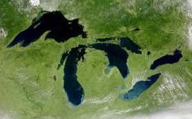
Climate Change To Profoundly Alter Great Lakes Region, Summary Report Says. Here's an excerpt of a recent study, courtesy of
eNews Park Forest: "
The GLISA summary report, "Synthesis of the Third National Climate Assessment for the Great Lakes Region," states that:
Increased
heat wave intensity and frequency, increased humidity, degraded air
quality and changes in mosquito- and tick-borne disease patterns in the
region will increase public health risks.
Extreme
rainfall events and flooding have increased in the region during the
last century and are expected to continue. Those trends could lead to
increased erosion, declining water quality and negative impacts on
transportation, agriculture, human health and infrastructure..."
"Risky Business" Report Aims To Frame Climate Change As Economic Issue. Following up on the New York Times, here's an excerpt from
The Wall Street Journal: "...
The
whole point was to have a bipartisan group who agreed on the nature of
the problem, which is that climate change is a huge economic risk," said
Mr. Paulson, who served under President George W. Bush. The study
concludes that within the next 15 years, higher sea levels, storm surges
and hurricanes could raise the annual price tag for coastal damage
along the East Coast and the Gulf of Mexico to $35 billion. Some
Midwestern and Southern agricultural areas could see a decline in yields
of more than 10% over the next five to 25 years due to increased
drought and flooding, unless farmers adapt their crops, according to the
study..."
* The Risky Business report, download and Executive Summary is
here.
*
Click here for the Risky Business Press Conference Live Stream.
The Losing Bet on Climate Change. Professional money manager and columnist Barry Ritholtz has an Op-Ed at
Bloomberg View
where he discusses something I've been talking about for some time:
climate volatility, and how companies will soon be divulging climate
volatility risk to their investors; here's an excerpt: "...
Changes
in weather are going to be disruptive for investors. Opportunities and
risks will abound. Your choices will be to either take advantage of
these opportunities for your clients or your own holdings or let them
pass by because you have come to the scientifically unsupported
conclusion that there is no such thing as global warming -- or maybe
there is, but it's only modest, and besides, it's natural and caused by
sunspots and not human activity, or whatever slice of agnotology your cognitive dissonance has foisted upon you. .."


The St. Croix is not forecast to crest until Friday at Stillwater.
ReplyDelete