By Paul Douglas
Any day you can drag yourself to the window and look out is a good day" my grandma liked to say. No argument there.
It's brisk, but no storms with names are moving in our direction, and complete strangers won't be whining about the dew point into Friday.
Residents of Winnipeg may bristle at the expression "Canadian air" but we're all breathing easier. "I noticed a difference getting off the plane" my brother in law, Bob Ball, told me. He lives in Bethesda, Maryland, where sauna-like conditions linger much of summer. It's worth remembering that D.C. was built on swampland neither Maryland nor Virginia wanted. Some things never change.
Skies clear; a postcard-worthy Thursday giving way to a late-week warm front. Remarkably, most of Friday & Saturday looks dry - any storms will be isolated until Sunday, when the next sloppy front sparks more widespread T-storms. Saturday looks like the better day for sunscreen and slow-motion boating.
Computer models do a much better job predicting hurricane track than intensity. A few models strengthen Arthur into a Category 1-2 storm as it passes over warm Gulf Stream water, sideswiping the Outer Banks on July 4th. Great timing.
===========
TUESDAY NIGHT: Evening showers, partial clearing late. Low: 53
WEDNESDAY: Better: becoming partly sunny, less wind. High: 72. Winds: NW 10-15
WEDNESDAY NIGHT: Mostly Clear and comfortable. Low: 54.
THURSDAY: Best day in sight. Sunny and perfect. High: 77
4th of JULY: Sunny start, late-day T-storm risk. Wake-up: 55. High: near 80
SATURDAY: Sticky sun, late night T-storms? Wake-up: 62. High: 84
SUNDAY: Hot sun, very humid with spotty T-storms. Dew point: 72. Wake-up: 72. High: 86
MONDAY: Unsettled. A few more showers. Wake-up: 68. High: 80.
TUESDAY: Morning sun, PM T-Storm. Wake-up: 62. High: 78.
==============
This Day in Weather History
July 2nd
1989: Softball sized hail near Dorset, and baseball sized hail at Nevis in Hubbard County.
1972: Freezing temperatures at Big Falls in Koochiching County.
==============
Sunrise/Sunset Times for MSP
July 2nd
SUNRISE 531 AM
SUNSET 903 PM
==============
Average High/Low for MSP
July 2nd
Average High: 83F
Average Low: 63F
==============
Moon Phase for July 2nd at Midnight
2.2 Days Before First Quarter
===================
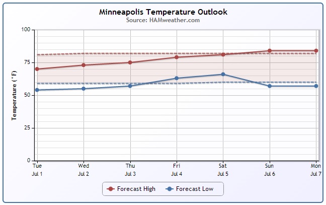
Minneapolis Temp Trend
Temperatures are expected to warm later this week/weekend after a brief cool snap through midweek.
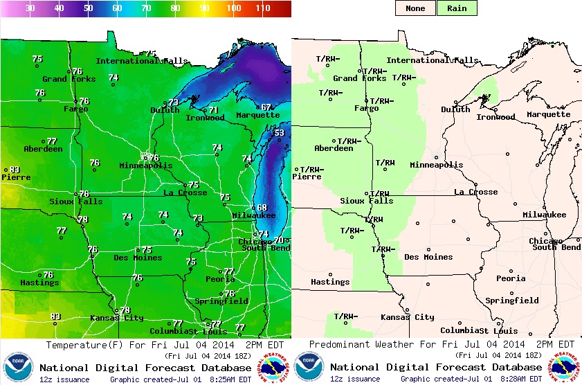
4th Forecast
As we approach the July 4th holiday weekend weather conditions will be souring a bit, but it won't be too bad. We'll likely have a few afternoon/evening T-storms popping up across parts of the state, but it won't be a washout. Saturday could be the wetter day of the weekend, while Sunday appears to be the drier/warmer day of the weekend. The graphic below shows temperatures and weather conditions for 2pm Friday, July 4th.
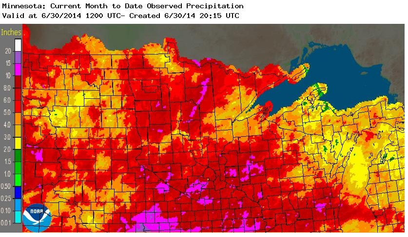
Minneapolis 2nd Wettest June on Record
June 2014 across the Midwest was VERY wet. Some spots across southern/southwestern MN saw nearly a foot of rain or more, while the Twin Cities saw officially 11.36" of rain. That's good enough for the 2nd wettest June on record behind the 11.67" set in 1874!
Thanks to Aaron Shaffer for the picture below at Minnehaha Falls.

2nd Wettest June on Record Cont.
Here's a nice write-up from the MNDNR and UMN State Climate Office about the 2nd wettest June
"The Twin Cities total of 11.36 inches fell just short of the June record of 11.67 inches set 140 years ago in 1874. The state record for the highest June total for an individual location remains unbroken - 15.63 inches at Delano in 2002. The impacts of the heavy June rainfall were apparent: flooded farm fields and delayed field work, flooded basements, mudslides and flooded roads leading to transportation disruptions, and negative consequences for outdoor activities including construction and outdoor recreation.
Some preliminary record-setting June totals for individual locations, by region, from north to south, include:
Ada 9.05 inches
Littlefork 9.14 inches
International Falls 10.19 inches
Kabetogama 11.58 inches
Dawson 8.27 inches
Chaska 13.24 inches
Glencoe 14.24 inches
Lakefield 10.96 inches
Waseca 12.31 inches
Luverne 13.84 inches
Redwood Falls 14.24 inches"
Read more HERE:
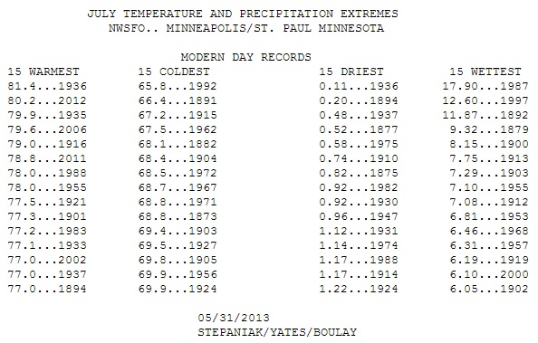
July Extreme
Let's hope July 2014 won't get close to any records! Take a look at how wet the wettest July on record is for MSP! Can you believe the record wettest July in MSP history is nearly 18" !! YIKES!!
Active in the Eastern U.S.
A slow moving cool front will stall along the Eastern Seaboard over the next couple of days, which not only will bring the threat of strong to severe storms to the Northeast, but it will also help to nudge our first named storm of the 2014 Atlantic Hurricane Season a little farther east by the weekend ahead. However, there will likely be big impacts along the East Coast through the next several days.
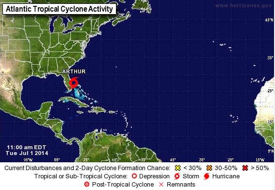
Keeping an Eye on Arthur
As of 10am Tuesday, the National Hurricane Center upgraded Tropical Depression #1 to Tropical Storm Arthur. Arthur is expected to make a slow pass along the east coast of Florida through the middle of the week and possible make a brief landfall with the extreme eastern edge of North Carolina by AM Friday. This system will likely have bigger impacts into our 4th of July Friday along the Eastern Seaboard as heavy rain, stronger winds and rip currents could make for a problematic next several day time period.
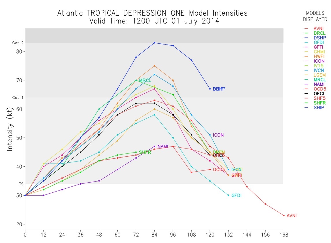
Forecast Wind Intensities
This is kind of an interesting graphic. It is a forecast of wind intensities for Arthur. Note that at the time this model was run, Arthur was still Tropical Depression #1. However, there are several models that suggest Arthur getting very close to hurricane status (74mph) by Friday.
Arthur Track
The forecast track for Arthur is to become a hurricane by AM Friday near the Outer Banks of North Carolina.
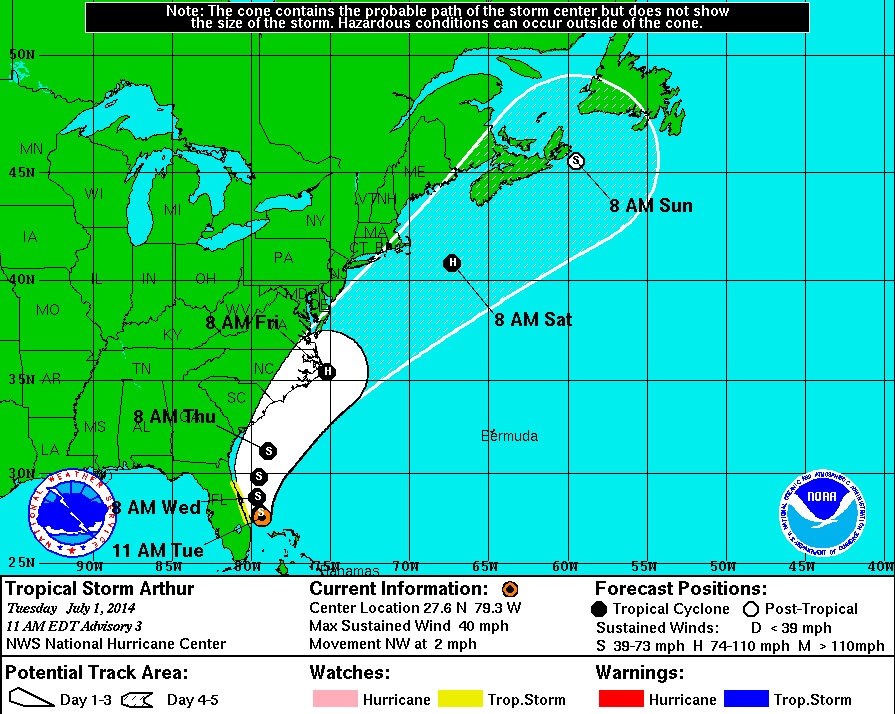
Stormy 4th of July
The forecast suggests a stormy outlook along the Eastern Seaboard on the 4th of July. Arthur could actually be a Category 1 with winds up to 74mph or greater by AM Friday!
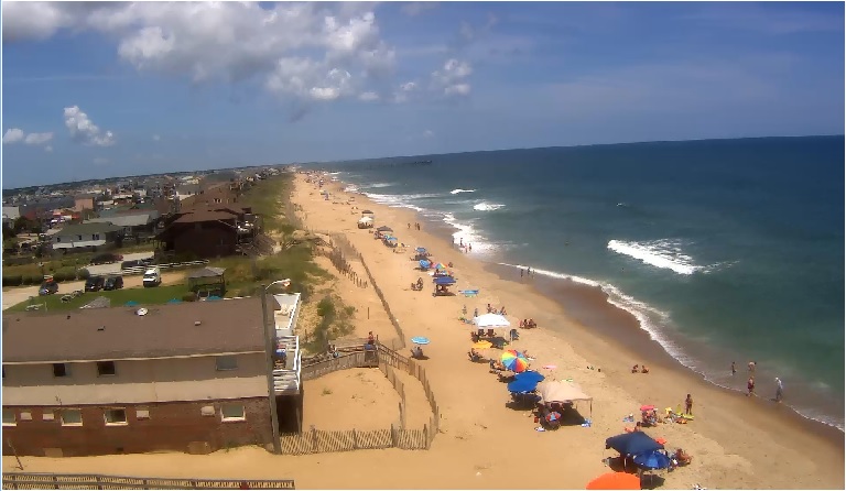
Kill Devil Hills, NC
Take a look at the beautiful weather conditions in Kill Devil Hills, NC on Tuesday afternoon! Weather conditions later this week could be MUCH different here... stay tuned for more.
See the current webcam from Sea Ranch Resort HERE:
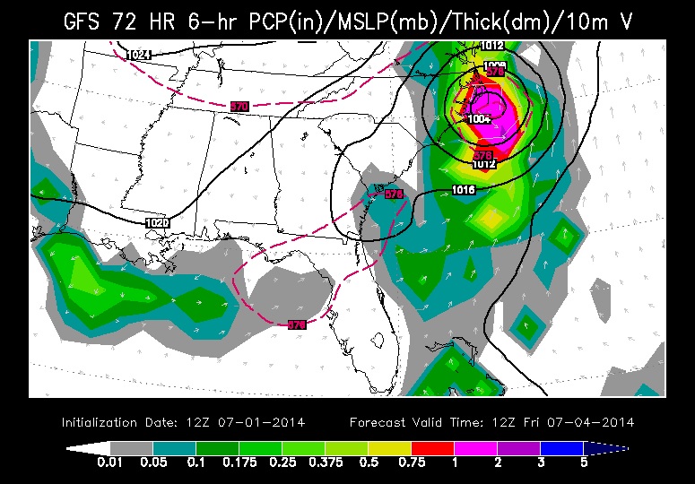
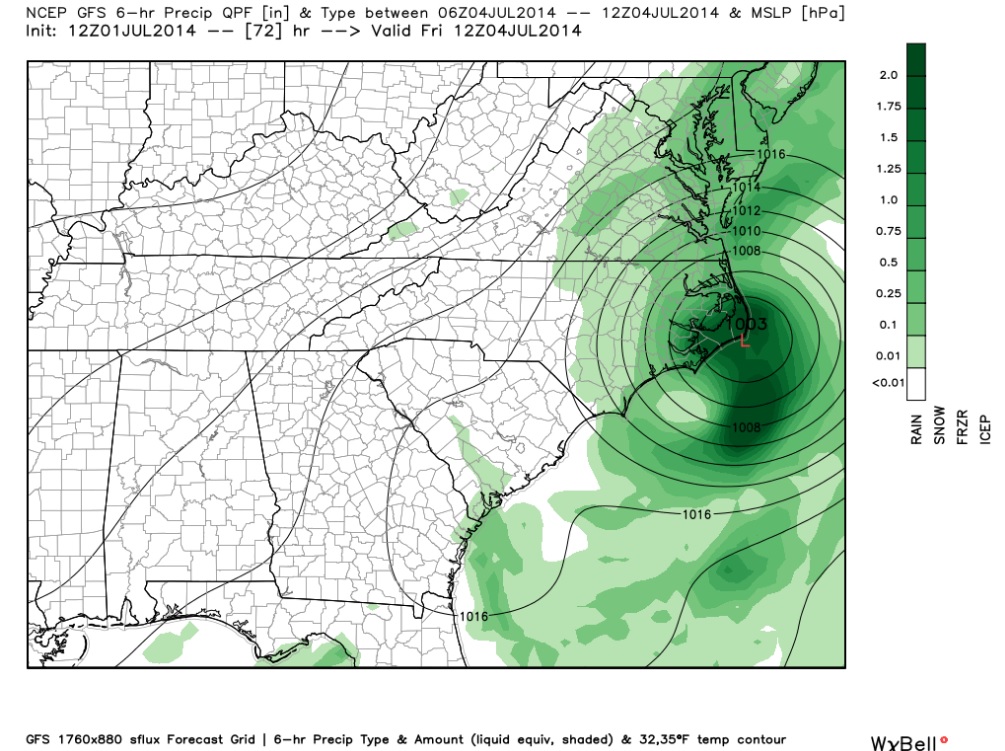
Rainfall Forecast
According to NOAA's HPC, the 5 day rainfall forecast suggetss a pretty heavy band of rain along the Eastern Seaboard through the first part of the weekend.

Atlantic Storm Names
Arthur becomes our first named storm of the 2014 Atlantic Hurricane Season, which started on June 1st and runs through November 30th. Bertha is the next name on the list.

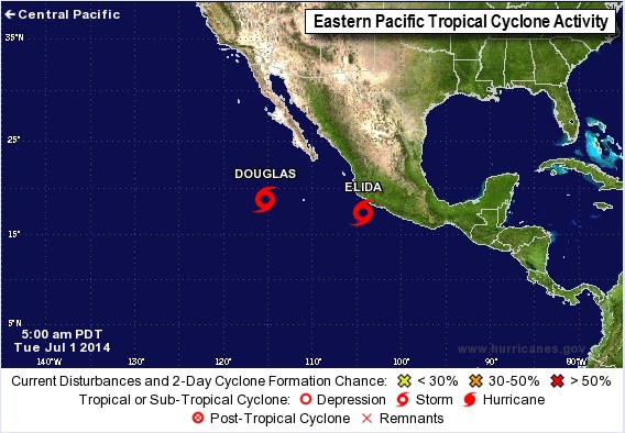
Active Eastern Pacific
Take a look how active the Eastern Pacific is. As of midday Tuesday, there were still 2 tropical storms ongoing in the Eastern Pacific Douglas and Elida. Both were moving WNW and not on track to make landfall with any major landmass.
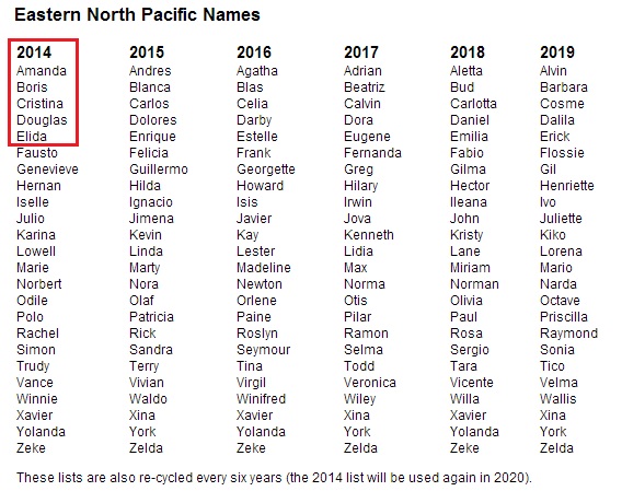
East Pacific Storm Names
Interestingly, we have already had 5 named storms in the Eastern Pacific, 2 of which were strong category 4 hurricanes! Keep in mind that both category 4 hurricanes were the strongest hurricanes to ever to develop that early in the season in the East Pac.
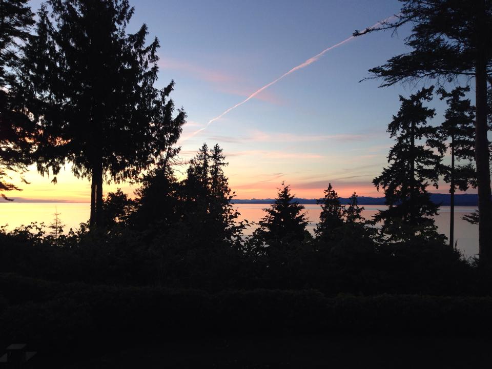
Warm and Dry in the Western U.S.
Thanks to Michelle Surgeson and Cameron Corbett for this stunning view from Qualcum Beach, Canada which is located on Vancouver Island in the Eastern Pacific! Tuesday was also Canada Day!! Happy Canada Day, eh!
Ridge in the West
Thanks to a ridge of high pressure over the western U.S., mostly dry and warm weather has settled in as far north as British Columbia. This ridge of high pressure will keep the heat turned on over the next few days with excessive heat continuing in the Southwest. Note in the graphic below how the lines bubble north in the western U.S. while they buckle south near the Great Lakes.
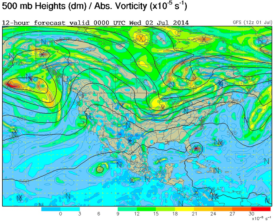
Highs From Normal Wednesday
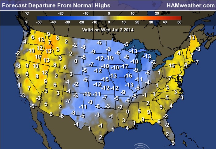
Highs Wednesday
Note how high temperatures on Wednesday nearly reflect the upper level pattern shown above. Warm/hot temperatures continues in the western U.S., while cooler temperatures continue in the central U.S.
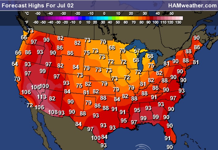
Highs Wednesday
By the way, Wednesday will be the 33rd consecutive day (Since May 30th) with days above 100° in Phoenix, AZ!
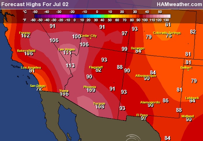
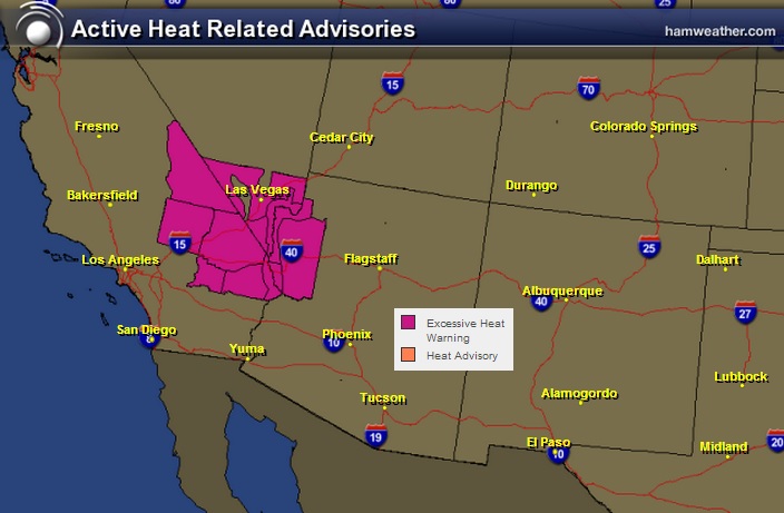
Excessive Heat
Forecast high temperatures through Wednesday could be anywhere from 102° to 125° !! Parts of Death Valley, CA could be within 10° of the hottest temperature ever 'officially' recorded on earth of 134° on July 10, 1913.
Solar Powered Tent
I think I found my next gift idea! Check this out!
"Now THIS solar powered off grid camping tent is probably the coolest tent I’ve ever seen. I’ve been an outdoorsman all my life and have owned many tents, but this concept is phenomenal. Now, this isn’t designed to haul around the hiking trails, as it would be too heavy for regular hiking/camping trips. But, it could probably be utilized well at events, and longer term camping. It’s designed to sleep 4 people comfortably, and would supposedly power you mobile devices through the built in solar panel array on the roof."
See more from Themindunleashed.org HERE:

The Cloud
Here's another great gift idea from Richard Clarkson...
"Multidisciplinary designer Richard Clarkson experiments with products, lights, and furniture in time split between his New York and New Zealand studios. One of his most elegant creations is Cloud, an interactive light shaped like a cumulus cloud that simulates a thunderstorm both in light and sound based on external input from either a remote control or motion sensors. From Clarkson’s website: The Cloud is an interactive lamp and speaker system, designed to mimic a thundercloud in both appearance and entertainment. Using motion sensors the cloud detects a user’s presence and creates a unique lightning and thunder show dictated by their movement. The system features a powerful speaker system from which the user can stream music via any Bluetooth compatible device. Using color-changing lights the cloud is able to adapt to the desired lighting color and brightness. The cloud also has alternative modes such as a nightlight and music reactive mode."
Read more from ThisisColossal.com HERE:

Thanks for checking in and have a great rest of your week! Don't forget to follow me on Twitter @TNelsonWNTV

Thank you for sharing valuable information. Nice post. I am very impressed to read this post. The whole blog is very nice I found some information here Thanks..Also visit my site Fort Lauderdale Moving Services Forward Van Lines is a family owned moving company.
ReplyDelete