88 F. high in the Twin Cities Sunday.
82 F. average high on August 3.
80 F. high on August 3, 2013.
Just Keep Smiling
I'm
older, but no wiser, yet one thing I know: Minnesota Nice evaporates
when you're standing in line for a Paul McCartney concert and the sky
begins to leak.
"Paul, if it rains you're in trouble!" a women
scowled, repeatedly poking me with hypodermic fingernails. Really? I
checked Doppler on my cell phone (something my team at a former company,
Digital Cyclone, invented in 2001) and was gratified to see others in
the crowd quietly doing the same. "Ma'am the shower is ending. And it
won't snow. That I can promise you."
Here's the thing: I love the
weather. I do my job for free. They pay me (actually I pay myself) to
put up with noisy skeptics. It's a never-ending MBA in public relations
and crowd control. No wonder I'm neurotic.
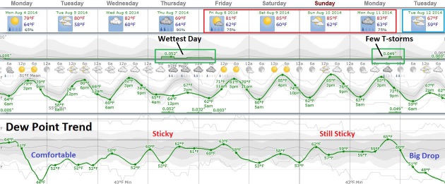
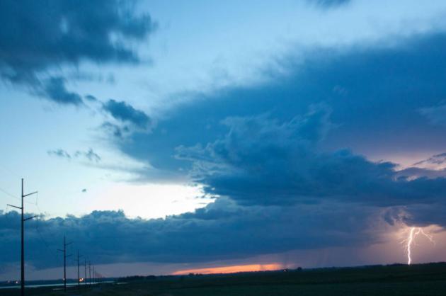
A northeast breeze drops dew points to comfortable levels today; most of the T-storms stay south and west of MSP into midweek.
Thursday
appears to be the wettest day, with sunshine and 80s next weekend
luring you back onto the lake. After record June floods and mostly-lousy
weekends in July we're trying to cram an entire summer into August.
Soak it up because the ECMWF hints at 60s for highs by the middle of next week.
PS: the sprinkles ended in time for McCartney's amazing rendition of "8 Days a Week".
No flurries either.
Definition of Isolated Thunderstorms.
When it rains hard in your yard the probability of precipitation goes
up to 100%, but the high-res visible loop from Sunday shows showers and
T-storms over less than 5-10% of the area during the midday and
afternoon hours; cumulonimbus flaring up ahead of a slightly cooler and
drier front that will leave us breating a bit easier today and Tuesday.
Loop: HAMweather.
A Summerlike Week. Next Week? Not So Much.
80s will be the rule this week, with the exception of Thursday, when
showers and T-storms will keep temperatures in the 70s. You'll notice a
welcome dip in dew point today, but humidity levels creep up as the week
goes on, a very lake-worthy weekend shaping up with mid-80s possible
both days. A cool frontal passage sparks more heavy T-storms Monday,
followed by a possible temperature tumble next week. Source:
Weatherspark.
Moisture Plume.
The amount of tropical moisture available to a stalled East Coast
frontal boundary is impressive, and I could see some isolated 6" amounts
near Wilmington North Carolina by 2 AM Wednesday. Slightly cooler,
drier air pushes south into Minnesota and Wisconsin; monsoon T-storms
producing localized flash flooding from California's Sierra Nevada into
Las Vegas and possibly Salt Lake City. 4 KM WRF data: NOAA and
HAMweather.
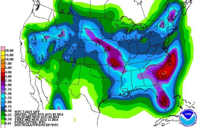
Carolina Flood Potential.
7-Day accumulated rainfall guidance shows some 4-5" amounts possible
from near Charleston to the Outer Banks of North Carolina, capable of
ongoing flooding headaches. More heavy showers and T-storms are likely
to dump 1-3"+ rains from near Sioux Calls to Des Moines and Kansas City.
Source: NOAA.
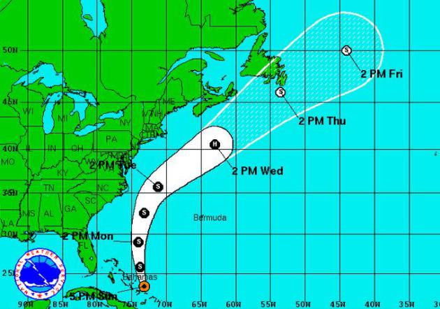
A Close Call from Bertha.
No, not Bertha Butt (one of the Butt Sisters), but Tropical Storm
Bertha, which may grow to minimal Category 1 hurricane status by
Wednesday, well east of the US coast. But the Carolinas will be brushed
by strong winds and rip currents, moisture from Bertha fueling
additional heavy showers and T-storms with potential flash flooding for
the Outer Banks. Storm track: NOAA NHC.
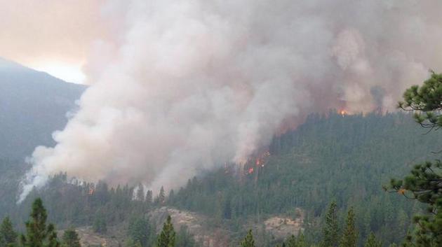
Gov. Brown Declares State of Emergency for California Wildfires. Here's the latest from
The Los Angeles Times: "
Gov.
Jerry Brown on Saturday declared a state of emergency due to the
effects of several wildfires burning in central and northern California
counties. Thousands of acres have burned in El Dorado, Amador, Butte,
Humboldt, Lassen, Madera, Mariposa, Mendocino, Modoc, Shasta and
Siskiyou counties, which have been suffering from lightning strikes and
high temperatures. Some homes have burned..."
Photo credit above: "
This July 28 photo by the U.S. Forest Service shows flames and smoke in the Sierra National Forest." (Burt Stalter / U.S. National Forest Service via AP).
As Wildfires Burn Through Funds, Washington Seeks New Way To Pay. Nothing like running out of money to sharpen one's focus.
Maine Public Broadcasting reports; here's an excerpt of a very interesting interview: "...
Together,
the Interior Department and the Forest Service, which bears the lion
share of wildfire fighting responsibilities, have budgeted over a
billion dollars for firefighting this year. That's five times more than
20 years ago, and even that may not be enough, if recent years are any
guide. There are other costs associated with wildfires, says Rachel
Cleetus, a senior climate economist with the Union of Concerned
Scientists..."
Photo credit above: "
Smoke rises
from a fire in Burney, Calif., Sunday, Aug. 3, 2014. A pair of wildfires
burning without restraint about 8 miles apart in northeast California
became the focus of state and federal firefighters as authorities
reported that one of the blazes had destroyed eight homes and prompted
the precautionary evacuation of a small long-term care hospital." (AP Photo/Record Searchlight, Clay Duda)
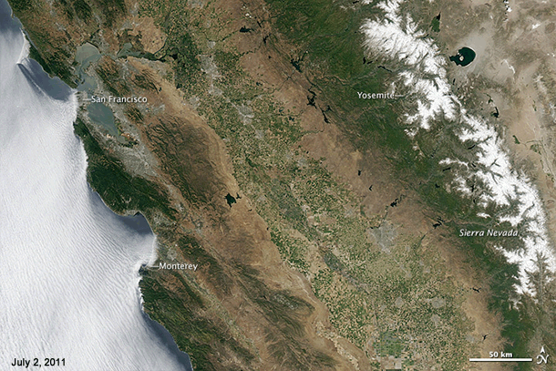
Downright Dismal Images of the Western Drought, A Record-Setter in California. The acceleration of drought out west, especially California, is remarkable.
Climate Central provides additional perspective; here's a clip: "...
California
is turning brown and you can see it from space. Look at the difference
between June 2011 and June 2014 in the animation of NASA images below.
Note the dwindling snowpack, as well. Sierra Nevada snowpack was just 18
percent of normal this spring..."
Animation credit: "
Pair of images above from the Moderate Resolution Imaging Spectroradiometer (MODIS) on NASA’s Aqua satellite." (NASA).
10 Cities Running Out Of Water. Most of them are in California, as
USA TODAY reports: "...
Based
on data provided by the U.S. Drought Monitor, a collaboration between
academic and government organizations, 24/7 Wall St. identified large
U.S. urban areas that have been under persistent, serious drought over
the first seven months of this year. The Drought Monitor measures
drought by five levels of intensity: from D0, described as abnormally
dry, to D4, described as exceptional drought. For the first time in the
Drought Monitor's history, 100% of California is under at least severe
drought conditions, or D2. It was also the first time exceptional
drought of any kind — the highest level — has been recorded in the state..."
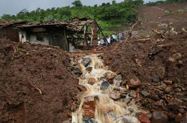
Otherworldly Downpour Precedes Deadly Landslide in India. When it does rain it's falling harder, with tragic consequences at times. Here's a clip from
The New York Times: "
When
the storm came to this tiny village on Wednesday morning, with a
resounding blast and mere seconds of a downpour so heavy it could not be
called rain, Dilip Bhagwa Lembeg was walking to his paddy fields. He
heard the blast, looked up to the hill behind him, and saw that the
mango trees on the hilltop were trembling. Seconds later, most of the
houses in the area were gone..."
Photo credit above: "Villagers
watch a rescue operation standing by mud and slush at the site of a
landslide in Malin village, in the western Indian state of Maharashtra,
Friday, Aug. 1, 2014. Heavy rains hampered efforts Friday by hundreds of
rescue workers digging through heavy mud and debris, as the death toll
from a landslide that engulfed an entire village in western India
crossed 50". (AP Photo/Rafiq Maqbool).

Extreme Flash Flooding In Italian Tourist Town Kills 4, Injures 20. The
UK Daily Mail
has details on another tragedy. Is the rain falling harder or is this
just the media doing a better job of reporting extreme rains that have
always been with us? I suspect the former, but I'm keeping an open mind.
Here's a clip: "
At least four people have died after a flash flood
swept revelers at a village festinval in Italy into a river. A furious
torrent carried off cars, kiosks and villagers, who were celebrating the
traditional "Feast of the Omens" in Molinetto della Croda, near Venice.
Around 200 people had taken shelter under a tent when "an avalanche of
water" struck, leaving more than 20 people injured, four badly,
authorities said..."
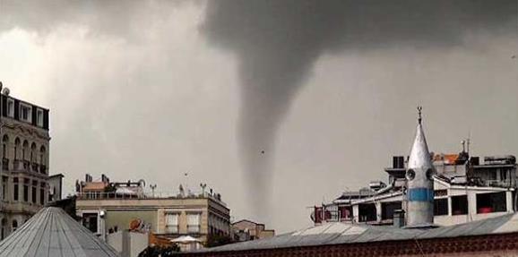
Heavy Rain Paralyzes Life Across Turkey. Istanbul was hit by a rare tornado; here's an excerpt from
Today's Zaman: "
İstanbul
was hit by heavy rain on Saturday evening, causing water to collect on
several roads, bringing traffic to a standstill. Many locals, heading
home from work, were trapped in their vehicles when floodwater
accumulated on the roads. Flooding caused traffic jams and congestion
problems throughout the city. Municipal workers worked all night to
clear streets across the city...."
Photo credit above: "A tornado struck the İstanbul neighborhood of Kasımpaşa amid fierce rain on Saturday." (Photo: Cihan).
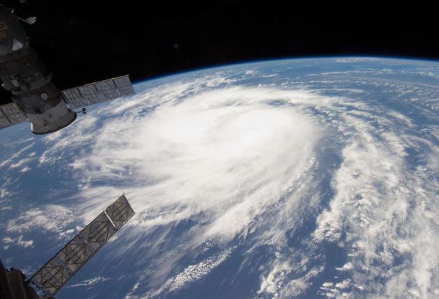
Science Fair Project Spins Up NASA Hurricane Study.
Are hurricanes becoming larger, and if so what are the economic
implications? Should we be focusing less on wind speed and category and
more on the size of a storm? Here's an excerpt of a fascinating study
from
NASA JPL: "...
They
found that the common practice of using only wind speed to represent
hurricanes in economic hurricane damage models is inadequate for large
storms, such as 2012's Hurricane Sandy. Zhai and Jiang are the first to
quantify the economic impacts of increasing hurricane size. Analyzing 73
hurricanes from 1988 to the present, Zhai and Jiang found that a
doubling in size, without a change in wind speed, more than quadruples
the economic loss a hurricane causes. Tripling its size multiplies the
loss by almost 20 times..."
Photo credit above: "
Alice Zhai and Jonathan Jiang." Image credit: NASA/JPL-Caltech.
Researchers Take New Approach To Hurricane Forecasting.
Track predictions are consistently accurate, but how do we make that
quantum leap and make a more accurate hurricane (intensity) forecast?
News 92 FM in Houston has an interesting story; here's an excerpt: "...
Forecasters
have gotten pretty good at forecasting a hurricane’s path, but when it
comes to intensity forecasting, especially intensity just before
landfall, researcher Alex Soloviev of Nova Southeastern University says
there just hasn’t been much progress. “During the last 25 years or so,
there has been no serious improvement in forecasting of hurricanes,”
Soloviev said..." (File photo of Hurricane Katia: NASA).
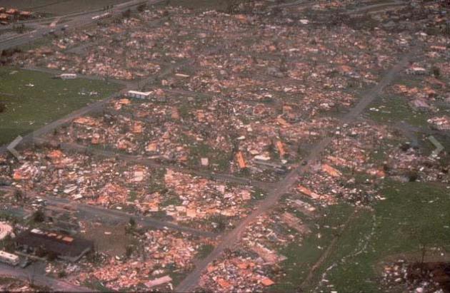
A Look At Some of History's Most Intense Hurricanes. RNN and
WDAM.com have a good recap of some of America's superstorms; here's an excerpt: "
Here’s a look at some of the most intense hurricanes to hit the United States.
Labor Day hurricane, 1935: This
hurricane is still ranked as the most intense hurricane to ever hit the
U.S. nearly eight decades after it struck the Florida Keys. Residents
in the area had very little warning or chance to evacuate, as the storm
was predicted to pass south. Survivors told The Associated Press their
families only knew something was wrong in the hours before landfall
when their barometers began showing low readings. While no wind speeds
are available, the storm’s pressure was measured at 892 millibars, one
of the lowest ever recorded. The unnamed hurricane killed 408 people in
the Keys, many of them World War I veterans working on a local
construction project..."
File photo above: Hurricane Andrew, 1992. "
Many
houses, businesses and personal effects suffered extensive damage from
one of the most destructive hurricanes ever recorded in America. One
million people were evacuated and 54 died in the hurricane." (Source: FEMA).
Only 6% of Weather-Related Deaths from 2006-2010 Were from Severe Weather.
It may be counterintuitive, but the vast majority of the roughly 2,000
American weather-related fatalities were due to extreme cold and extreme
heat. More details from
WWLP.com.
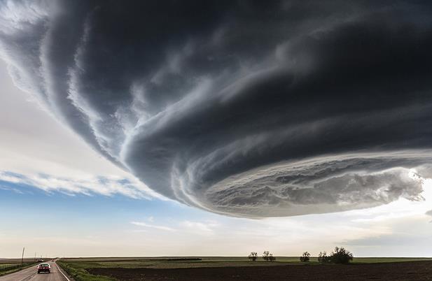
Dramatic Image of Supercell Wins National Geographic Contest.
Yes, this is one of the most spectacular photos I've ever seen of a
strongly rotating thunderstorm. These are the extreme storms that often
produce damaging hail and tornadoes. More from
The Capital Weather Gang: "
A beautiful, dramatic image of a Colorado supercell thunderstorm won first place in National Geographic’s 2014 Traveler Photo Contest.
The image, taken by photographer Marko Korošec of Slovenia, is a
striking representation of the power of thunderstorms in North America.
Low precipitation supercells, like this one in Colorado, are most common
in the high plains of the United States. They provide excellent
opportunities to visualize the rotating updraft — part of what makes
these storms so dangerous..."
Photo credit above: "
The Independence Day" – "
While
on storm chasing expeditions in the Tornado Alley in USA I have
encountered many photogenic supercell storms. This photograph was taken
while we were approaching the storm near Julesburg, Colorado on My 28th,
2013. The storm was tornado warned for more than one hour, but stayed
an LP storm through all its cycles and never produced a tornado, just
occasional brief funnels, large hail and some rain." (Photo and caption by
Marko Korošec / National Geographic Traveler Photo Contest)
After Ebola.
The world is a dangerous place, but all other risks pale compared to
virus and pandemic. That's the argument of this harrowing story at
The New Yorker,
including the story of Patrick Sawyer, the only American to die from
ebola so far, was scheduled to fly to Minnesota - he never had a chance
to get on that plane: "...
But as the world’s worst Ebola epidemic
yet spreads through western Africa, it is important to remember that we
won’t always see something. “The single biggest threat to man’s
continued dominance on this planet is the virus,” the Nobel
Prize-winning biologist Joshua Lederberg once wrote. Few epidemiologists
would disagree. There is no bomb, no poison, no plan of attack with the
potential to do as much damage..."
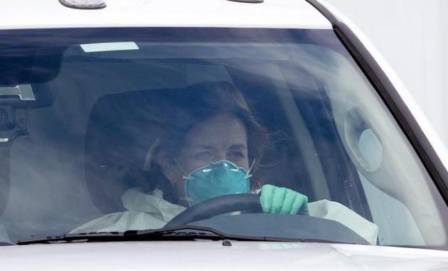
Image credit above: "
A
woman in protective clothing drives an ambulance after departing
Dobbins Air Reserve Base in Marietta., Ga., en route Emory University
Hospital in Atlanta Saturday, Aug. 2, 2014. A specially outfitted plane
carrying Dr. Kent Brantly from West Africa arrived at a military base in
Georgia. Brantly was taken to the Atlanta hospital. Another American
with Ebola is expected to join him at the hospital in a few days." (AP Photo/John Bazemore).
When It's Bad To Have Good Choices.
I've noticed for some time (in me). More choices sounds great, but it
also makes me more neurotic - having to choose. This is why you never
wander into Byerly's on an empty stomach. Here's a clip from
The New Yorker: "...
Perhaps,
then, what we’re really seeing is how the old fear of missing out plays
out in the brain. We’re surrounded by great choices to make, great
places to be, great things to do—and that’s wonderful. But when we’re
made to commit to one, just think of everything that gets away. Shenhav
himself refers to it as the “neural correlates of First World problems.”
We know that someone else is eating that delicious ice cream
that we
passed up—or filling that job that we turned down..." (Image credit:
Psychology Today).
TODAY: Partly sunny, less humid. Dew point: 56. NE 8. High: near 80
MONDAY NIGHT: Mostly clear, more comfortable sleeping. Low: 57
TUESDAY: Comfortable sunshine. Dew point: 54. High: 80
WEDNESDAY: Sun fades, isolated thunder late. Wake-up: 55. High: 82
THURSDAY: Wettest day of the week. T-storms likely. Wake-up: 58. High: 76
FRIDAY: Unsettled, spotty T-storms. Wake-up: 63. High: 81
SATURDAY: Warm sun, hit the lake. Dew point: 59. Wake-up: 62. High: 84
SUNDAY: Sticky sunshine, feels like July. DP: 63. Wake-up: 63. High: 85
Climate Stories....
Ignoring Climate Change is Risky Business. U.S. News has the article following up on the recent "Risky Business" report; here's the introduction: "
The
U.S. faces significant and diverse economic risks from climate change.”
No, that’s not a scary pronouncement from the Obama administration to
justify its climate policies. That’s the first sentence of the report “Risky Business”—
from a staid committee co-chaired by former New York Mayor Michael
Bloomberg, former George W. Bush administration Treasury Secretary Henry
Paulson and retired hedge fund founder Tom Steyer — urging the business
community “to rise to the challenge and lead the way in helping reduce
climate risks...”
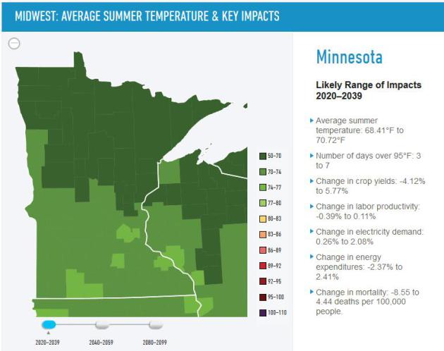
Minnesota: Likely Impacts 2020-2039. Here's a
graphic
from the recent "Risky Business" report, detailing the changes that may
be coming to Minnesota and the rest of the planet. It's a worthy read.
Global Warming Kicks up Record Pacific Trade Winds.
Remember that everything in the atmosphere-ocean-cryosphere system is
interconnected. It's one big domino effect and we're in uncharted
waters. Here's an excerpt from
Discovery: "
Rapid
warming of the Atlantic Ocean is "turbocharging" Pacific equatorial
trade winds, according to new research. These are the strongest trade
winds since recording began in the 1860s, according to scientists from
the University of New South Wales and the University of Hawaii. "The
increase in these winds has ... amplified the Californian drought,
accelerated sea level rise three times faster than the global average in
the Western Pacific and has slowed the rise of global average surface
temperatures since 2001," the study's authors report..." (image above: iStock).
* more on this research at
phys.org and
nature.com.
Where Should You Ride out Global Warming? Hint: It's Not The South. Here's an excerpt of an interesting analysis at
al.com: "
University of Washington atmospheric science professor Dr. Cliff Mass says in his blog this week that the Pacific Northwest is the spot in
the lower 48 states to ride out global warming. Mass starts out by
assuming global warming is real and "will take hold" later this century.
Here's why he says the "Pacific Northwest is the place to be."
1. Sea level rise
It's
not a big problem in the Pacific Northwest, Mass says, because of the
general rise in elevation along Northwest shorelines. "Forget Florida,"
he says flatly. And South Alabama's beaches won't fare much better, his
map indicates..."
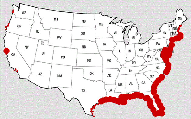
Image credit above: "
Based
on U.S. Geological Survey publications including threat maps,
meteorology professor Dr. Cliff Mass shows the coast areas most
vulnerable to rising water caused by global warming." (Cliff Mass Weather Blog).
Why The Northwest Is A Potential "Climate Refuge" From Effects of Global Warming.
Here's another look at Cliff Mass's recent post, and I certainly don't
disagree that The Pacific Northwest has many things going for it when it
comes to climate volatility, access to water and rising sea level. I'm
not sure how this doesn't devolve into a PR scuffle (brought to you by
the Local Chamber of Commerce!) My town will do better than your town,
etc etc. I would argue that Minnesota, the Upper Midwest and Great Lakes
may also fare well, as wet areas become even wetter in the years to
come, which will bring it's own unique set of problems and issues. Time
will tell. Here's an excerpt from KPLU News: "...
So,
I can go through one item after the other of major changes that are
going to happen under global warming. And most of them will not produce
serious effects here in the Northwest,” Mass said. Mass also cites
researchers at Portland State University, who have published a study suggesting the Willamette Valley could become a place to ride out worsening conditions of a warming planet."
Map credit above: "
The colored dots plot out expected effects of climate change.
" Courtesy Cliff Mass.
New Study Sees Warming Atlantic Behind a Host of Recent Climate Shifts. Andrew Revkin reports at
The New York Times; here's the intro: "
Using
climate models and observations, a fascinating study in this week’s
issue of Nature Climate Change points to a marked recent warming of the
Atlantic Ocean as a powerful shaper of a host of notable changes in
climate and ocean patterns in the last couple of decades — including
Pacific wind, sea level and ocean patterns, the decade-plus hiatus in
global warming and even California’s deepening drought. The study, “Recent Walker circulation strengthening and Pacific cooling amplified by Atlantic warming,” was undertaken by researchers at the University of New South Wales and University of Hawaii..."
China's Surprise on Climate Change.
Yes, the effort to wean ourselves off fossil fuels has to be a global
effort, and China now emits more greenhouse gases into the atmosphere
than the USA. They're starting to realize they have a longer term
problem, and challenge. How do you keep the lights on, grow the economy,
move more people into the middle class, with far less carbon-based
pollution? Here's an excerpt of an Op-Ed at
USA TODAY that caught my eye: "...
Taking
a long view, Chinese leaders see the threats posed by rising sea
levels, droughts and other effects of climate change. For all these
reasons, China is considering its first mandatory cap on coal use.
Whether that will happen, or be sufficient, remains uncertain.
Sustaining economic growth that has lifted a million people out of
poverty remains China's overriding priority. Signals of its intentions
could emerge at climate talks next month in New York, in December in
Peru and next year in Paris. That's where the United States comes in. As
the two biggest emitters of greenhouse gases, China and America hold
the key on global warming..."


"Soak it up because the ECMWF hints at 60s for highs by the middle of next week."
ReplyDeletePaul...I didn't need to know this just yet. I think I'm going to go cry now.