75 F. high in the Twin Cities Tuesday.
75 F. average high on September 9.
94 F. high on September 9, 2013.
Minnesota Weather History on September 9. Source: MPX National Weather Service:
2002:
A late-season tornado strikes Albertville just after midnight
.According to a damage survey conducted by NWS personnel, it touched
down on the eastern edge of Cedar Creek Golf Course, then it moved
straight east and dissipated in a city park just west of the railroad
tracks. It completely tore the roof off of one home. Roofs were
partially off a number of other homes, many attached garages collapsed,
and a couple of houses were rotated on their foundation. About 20 homes
were damaged, nine of which sustained significant damage.
1986: 3 inch hail fell in Watonwan County.
1947: Downpour across the Iron Range. Hibbing got 8.6 inches in three hours.
1931: St Cloud's high was 106 degrees, while it reached 104 degrees in Minneapolis.
1910:
Duluth had the shortest growing season ever with frost free days from
June 14 to September 10 (87days). Normally the frost-free season is 143
days.
Supernaturally Green
"Look
at how green it is!" the San Diego passenger sitting next to me gasped
as we pulled up to the MSP terminal. I can confirm that San Diego, like
much of California, is an oasis of sickly-green, surrounded by dying
vegetation, nearly-empty reservoirs and dry creek beds.
All of
which tempers my temptation to complain about this morning's gulley
gusher. An inch or two of rain falls early this morning, adding to the
31.3 inches of precipitation so far in 2014; 8 inches wetter than
normal, to date.
Today's storm is more reminiscent of late
October, drawing on huge north-south temperature contrasts and a jet
stream still dipping unusually far south. Steering winds aloft have been
stuck overhead since June, cutting down on extreme heat, and keeping us
wetter than average, overall.
Today redefines the meaning of foul
with a slow, rainy AM commute. A cold north wind kicks in behind the
storm, gusting to 30 mph as temperatures sink thru the 50s. A second
shot of moisture arrives Friday; the atmosphere aloft ALMOST chilly
enough for a rain-snow mix Friday night. Frost outside the metro early
Saturday gives way to 60s and 70s next week.
This front? A mere shot across the bow.
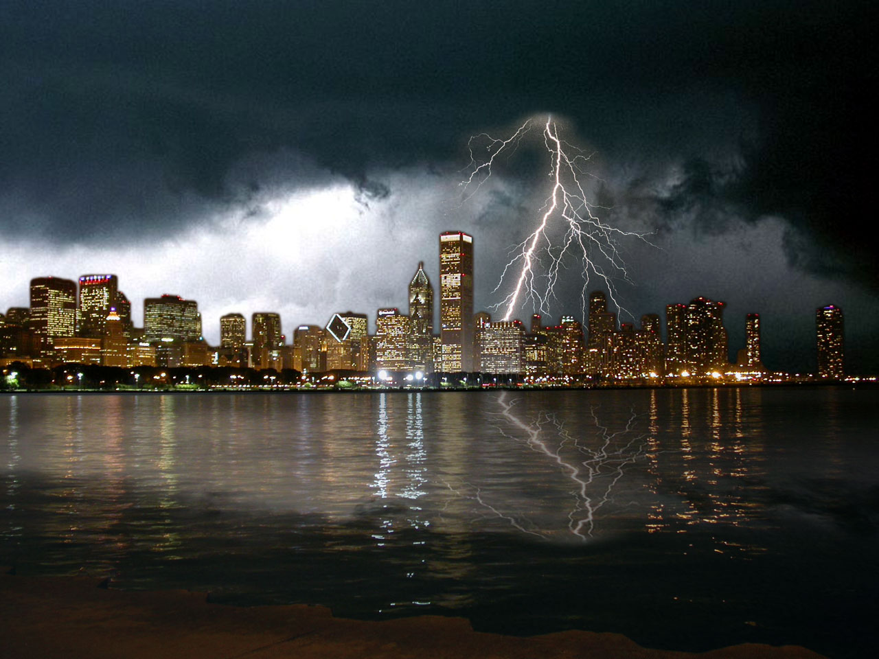
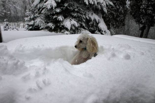
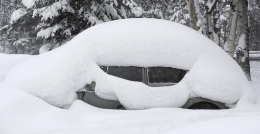
* photo credit above: Trista Dunsmoor.
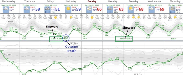
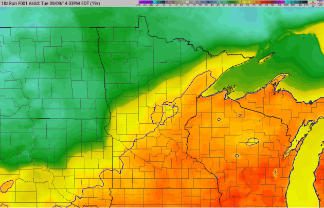
October-ish.
Maybe this cold front will tamp down the mosquitoes (and pollen). Maybe
that's wishful thinking until the first widespread frost. Expect 50s
the next few days, a few showers possible late Friday, and if skies
clear and winds drop off a light frost can't be ruled out Saturday
morning outside the metro. I wouldn't pack away the shorts anytime soon:
60s and a few 70s return next week.
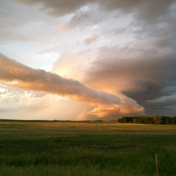
An Autumnal Storm.
Widespread smears of moderate to heavy rain are commonplace with
October storms, but still a bit rare on the 10th day of September. A
large contrast in temperature coupled with a stormy wrinkle in the
steering winds aloft will squeeze out heavy rain early this morning, but
we dry out by midday with some anemic sun possible by afternoon as
north winds howl at 15-30 mph. 60-hour accumulated rainfall prediction:
NOAA and HAMweather.
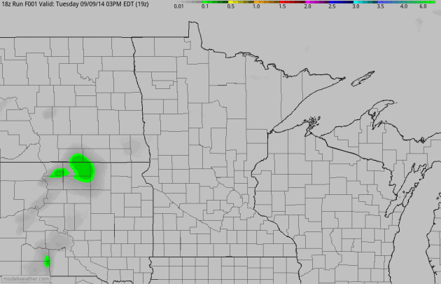
A Sign of the Times.
Forget the calendar, as far as the atmosphere is concerned
"meteorological autumn" really kicked off around September 1, and it
will certainly feel like fall into Saturday morning; temperatures as
much as 20F cooler than average. 4 KM NAM 2-meter temperature outlook:
NOAA and HAMweather.
Hope For A Strong El Nino Fade in Parched California.
Because it's the intense El Nino warming events in the Pacific that
often divert wet storms into central and southern California. More
details in this clip from a
New York Times story: "..
.Long-term
weather forecasters say it is now unlikely that a strong El Niño will
develop this fall, dimming hopes in California for heavy rains that
might bring relief from a severe drought. In its latest monthly forecast,
the federal Climate Prediction Center in College Park, Md., said that
while there was still about a two in three chance that El Niño would
develop, perhaps in the next two months, it would most likely be weak..."
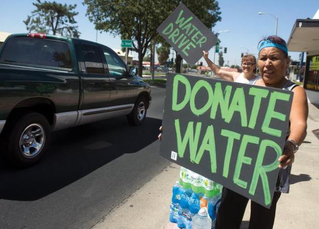
Photo credit above: "Volunteers
appeal to community members for donation Saturday, Sept. 6, 2014 at the
Porterville Water Challenge on Olive Street in Porterville, Calif.
Several locals started their own water challenges to help East
Porterville area residents whose well went dry for months." (AP Photo/The Porterville Recorder, Chieko Hara).
El Nino Watch: 6 Months and Still Counting.
Worried about the polar vortex reappearing next winter? ENSO-neutral
winters (no La Nina or El Nino) tend to be unusually harsh. If the
Pacific Ocean does warm significantly into a moderate El Nino event the
odds of bitter, sustained cold diminish a bit. Here's a clip from
Climate Central: "...
The
latest update, issued Thursday, notes that some aspects of the tropical
Pacific’s behavior look more promising than they did at the time of the
last update in early August,
but keeps the likelihood of an El Niño developing at 60 to 65 percent.
“We still believe that the event will occur,” CPC forecaster Michelle
L’Heureux told Climate Central. When might this happen? Sometime in the
September to November time frame, the CPC forecast said. Once the El
Niño does form, it is expected to continue into the early part of 2015.
The event, though, is only expected to be a weak or moderate one,
L’Heureux said..."
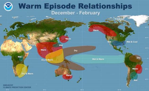
Image credit above: "
The climate impacts typically associated with an El Niño during the months of December, January, and February." Courtesy of NOAA.
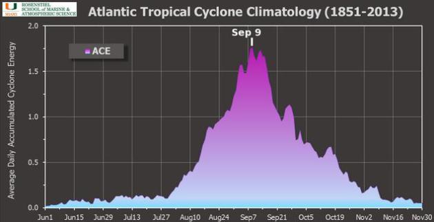
Peak of Hurricane Season Comes Quietly This Year.
Brian McNoldy has a good summary of what drives peak hurricane season
and why it's been so quiet so far in 2014; here's an excerpt from
his blog: "
Although
the Atlantic is fairly calm today, if you average activity over the
whole 163 years of records, September 9 is actually the climatological
peak! There are numerous ways to define "activity" of course, and there
are numerous time periods one could use to create the average. But for
this claim, I'm using a standard metric called Accumulated Cyclone
Energy (ACE), and the full 1851-2013 period..."
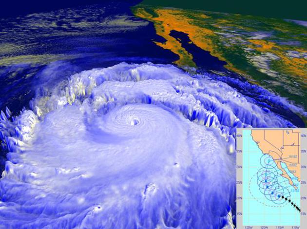
Remembering The San Diego Hurricane of 1858. The Weather Channel
has a fascinating story about the rare hurricane that battered the
small town of San Diego in 1858. I don't want to imagine what would
happen if a similar storm struck today. Here's a clip: "The
year was 1858. Abraham Lincoln was running for a seat in the U.S.
Senate. The start of the Civil War was still three years away. A stage
coach trip from Missouri to the young state of California took nearly a
month. And in Southern California, the town of San Diego had grown to a
little more than four thousand people. In the final days of September,
1858, those four thousand people experienced a storm like no other
before it. A hurricane in the eastern Pacific moved northward from the
warm waters of the tropics toward the California coast. This one took a
different path from the usual. Instead of moving away from land, it
headed north-northeast toward the California coast..."
Image credit above: "
In
September 1997, powerful Hurricane Linda, shown in this NASA rendering
created with data from the NOAA GOES-9 satellite, was briefly forecast
to strike Southern California, most likely as a tropical storm, as shown
in the inset forecast track from the Naval Research Laboratory’s Marine
Meteorology Division. The storm eventually turned westward away from
land, but still brought rainfall to parts of Southern California and
high surf." Main image credit: NASA/NOAA Inset image credit: NRL/NCEP.
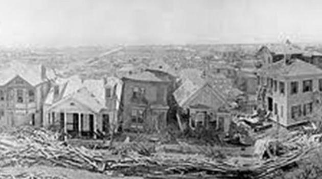
September 8, 1900: When a Hurricane Changed History. There still hasn't been anything as horrific as the Galveston Hurricane of 1900; here's an excerpt of a review at
click2houston.com: "...
On
September 8 - 114 years ago today - Galveston’s path through history
was radically changed. What is known as the 1900 Storm made landfall on
the island as a category 4 hurricane. Much like the Bolivar during Ike,
the storm surge eviscerated the city, which to some extent, is still
dealing with the ramifications today. An estimated 8000 people died,
mostly in Galveston. The 1900 Storm remains the record holder for the
largest loss of life from a natural disaster in the USA..."
Water's Edge.
Reuters
has a thorough, comprehensive and rather remarkable series focused on
rising sea levels. As water warms it expands, and that has implications
for homeowners and businesses along America's coastline. Here's an
excerpt of Part 1: "...
All along the ragged shore of Chesapeake Bay
and the Atlantic coast of the Delmarva Peninsula, north into New England
and south into Florida, along the Gulf Coast and parts of the West
Coast, people, businesses and governments are confronting rising seas
not as a future possibility. For them, the ocean’s rise is a troubling
everyday reality. This is the first in a series of articles examining
the phenomenon of rising seas, its effects on the United States, and the
country’s response to an increasingly watery world. Other stories will
show how other nations are coping..."
Fields of Green a Desert for Bees.
The Star Tribune
takes a look at whether a new class of insecticides applied on seeds to
reduce the impact of pests may be crippling bee populations in the
process; here's an excerpt: "...
Bayer CropScience, Monsanto and
others in agribusiness say there is no evidence that neonicotinoids are
to blame. Years of research went into their development, including
studies that concluded the low doses bees encounter as they forage for
pollen and nectar are insufficient to kill them, company officials say.
Yet beekeepers, environmentalists and many scientists are raising a
growing chorus of disagreement. Dozens of studies have now found that
low doses of neonicotinoids may not kill bees outright, but can cripple
their highly sophisticated navigational and communication skills, and
hamper a queen’s reproduction..."
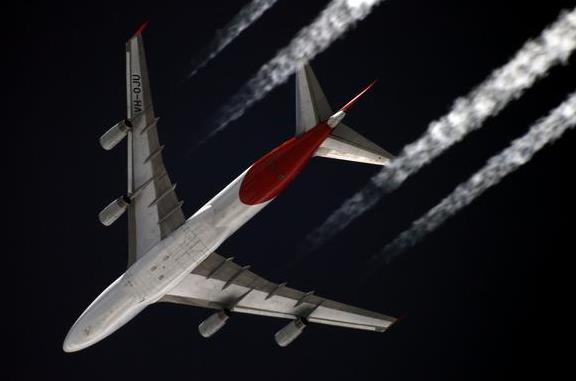
Airlines Take The Bump out of Turbulence. Here's an excerpt of an interesting article at
The New York Times: "...
Turbulence
poses a particular challenge because it cannot be seen by satellite or
radar. But meteorologists use complex weather models as well as reports
from pilots to predict areas of heavy turbulence. Sensors on some planes
operated by Alaska Airlines, American Airlines and Delta Air Lines can
automatically relay turbulence information to dispatchers to look for
alternative routing for later flights. An average of 36 people have been
injured as a result of turbulence each year since 2002, according to
the F.A.A., which records only the most severe cases..."
Photo credit above: "
Amanda Terborg, an Aviation Weather Center meteorologist in Kansas City, Mo." Credit Dan Gill for The New York Times.
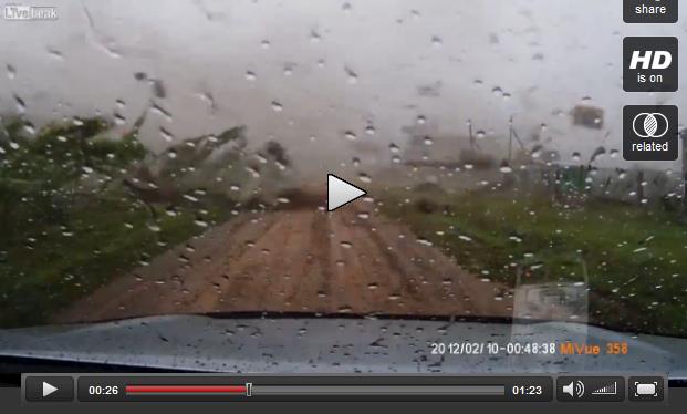
World's Shortest Tornado "Chase"?
You just can't make this stuff up. A weather enthusiast in Russia pulls
out of his garage with the dashcam going, gets onto the road and sees a
tornado coming, pulls back into his garage, which is no longer in one
piece. The video clip at
LiveLeak is worth a look: "
Russian
guy pulls out of his garage just as a tornado arrives. tries to go back
inside but alas, the garage is no more. Note, Dashcam date is
incorrect. This happened only a few days ago (29/08/2014 in Bashkiria,
Russia)..."
Credit: Рябоконь А.Н.
"Tornado Shield" Helps Protect Against Storm-Flung Debris.
Let's hope it's an EF-0 or EF-1 tornado, but any chance you have to
protect yourself against flying debris is a good thing. Details on this
new contraption via
Gizmag: "...
After
zipping yourself into the Tornado Shield, you then lie down on the
floor in the safest place you can find (such as a bathtub). While it
won't keep you from being crushed, its ballistic nylon construction is
intended to protect against lacerations caused by flying bits of debris –
such injuries are the most common type suffered by tornado victims.
Steve has tested the material against various glass, metal and wooden
objects, of the type that might be whizzing through the air in a
building being demolished by a tornado..."
Baseball Caught Looking As Fouls Injure 1,750 A Year. I had no idea. Here's a snippet from a story at
Bloomberg: "...
About
1,750 spectators get hurt each year by batted balls, mostly fouls, at
major-league games, or at least twice every three games, a
first-of-its-kind analysis by Bloomberg News has found. That’s more
often than a batter is hit by a pitch, which happened 1,536 times last
season, according to Elias Sports Bureau Inc.
The 8-year-old boy was one of four fans injured at the May 20 game,
according to a “foul-ball log” and other first-aid records at the
Braves’ Turner Field..."
Photo credit above: Rodger Mallison/Fort Worth Star-Telegram via AP. "An
usher, upper center, gives first aid to a fan after he was hit in the
face by a foul ball during a baseball game between the Texas Rangers and
the Oakland Athletics in Arlington in July 2011."
TODAY: Heavy rain tapers early. Mostly cloudy, gusty and much cooler. Winds: N 15-30. High: 59
WEDNESDAY NIGHT: Partly to mostly cloudy, chilly. Low: 42
THURSDAY: More clouds than sun, brisk - feels like late October. High: 58
FRIDAY: Clouds increase, showers late. Wake-up: 41. High: 55
SATURDAY: Frost risk outside metro. Cool sun. Wake-up: 37. High: 59
SUNDAY: Mix of clouds and sun, still dry. Wake-up: 47. High: 64
MONDAY: Mostly cloudy, showers south. Wake-up: 51. High: 62
TUESDAY: Sunnier, quite pleasant. Wake-up: 46. High: 67
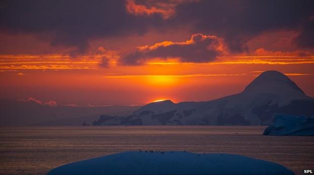
Climate Stories....
Greenhouse Gas Leves Rising At Fastest Rate Since 1984. Here's an excerpt from an update by
The BBC: "...
About
half of all emissions are taken up by the seas, trees and living
things. According to the bulletin, the globally averaged amount of
carbon dioxide in the atmosphere reached 396 parts per million (ppm) in
2013, an increase of almost 3ppm over the previous year. "The Greenhouse
Gas Bulletin shows that, far from falling, the concentration of carbon
dioxide in the atmosphere actually increased last year at the fastest
rate for nearly 30 years," said Michel Jarraud, secretary general of the
WMO..."
Photo credit above: "
Concentrations of CO2 in the atmosphere rose rapidly in 2013." Source: SPL.
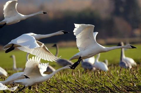
Climate Change Will Disrupt Half of North America's Bird Species, Study Says. Here's an excerpt from a sobering article at
The New York Times: "...
Those are some of the grim prospects outlined in a report released on Monday by the National Audubon Society, which found that climate change
is likely to so alter the bird population of North America that about
half of the approximately 650 species will be driven to smaller spaces
or forced to find new places to live, feed and breed over the next 65
years. If they do not — and for several dozen it will be very difficult —
they could become extinct..."
Photo credit above: "
Trumpeter
swans are among the species that, by 2050, are not expected to be able
to live in most of their current territory, according to a report." Credit Elaine Thompson/Associated Press.
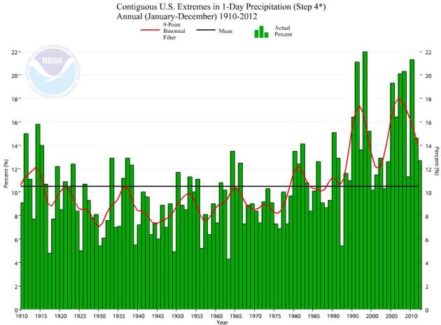
Extreme 24-Hour Precipitation Trends 1910 - 2012. I'm
no rocket scientist, as my wife reminds me daily, but I detect a trend.
Data above (NOAA NCDC) is for the Lower 48 states; trends over the
Southwest USA are flat; Monday's historic rains in the Phoenix area
(3-5+" of rain) were the heaviest one-day totals ever recorded, but some
of this moisture was leftover from Norbert, a fizzling hurricane off
the coast of Baja Mexico.
Extreme Snowfall Events Will Continue Even in Global Warming, Says Study. New research highlighted at
Capital Weather Gang caught eye; here's a clip: "...
Paul
O’Gorman, a professor at MIT’s Department of Earth, Atmospheric, and
Planetary Sciences, used model simulations to investigate the impact of
global warming on both average, day to day snowfall amounts as well as
the extreme snowfall events. He found that while average daily snowfalls
could decrease by 65 percent by the late 21st century, the extreme
snowfall events only decreased by eight percent in the model
simulations. In fact, in some high-latitude cases, the models suggested
that extreme snowstorms could deposit 10 percent more snow..."
Rising Temps. Won't Halt Blizzard Hazard.
At higher latitudes the frequency of blizzards may actually increase,
which I found interesting, which made me ponder whether that's better
than rising sea levels in Florida or perpetual drought in California and
Arizona.
The Daily Climate has more details on the new winter research referenced above: "...
The
study found that, under high warming scenarios, those low-lying regions
with average winter temperatures normally just below freezing would see
a 65 percent reduction in average winter snowfall. But in these places,
the heaviest snowstorms on average became only 8 percent less intense.
In the higher latitudes, extreme snowfall became more intense, with 10
percent more snow, even under scenarios of relatively high average
warming. There is a relatively narrow temperature range − just below
freezing point − at which the heaviest snowfalls seem to occur..."
Time To Tax Carbon.
Harvard Magazine has an Op-Ed; here's an excerpt that caught my eye: "...
As
a means of limiting greenhouse gases, a tax on the carbon content of
fossil fuels competes with proposals for outright regulations (such as
those advanced by the Obama administration) that would limit electric
power-plant emissions, and with cap-and-trade systems that let such big
polluters trade permits among themselves, always seeking the most
efficient means of reducing emissions. No solution to this massive
problem will make everyone happy, so the best outcome will involve
striking an optimal balance. A carbon tax may do that because it raises
revenue, and thus the additional possibility of redeploying those funds
in ways that stimulate economic growth..."
Why A Tax on Carbon Can Help Climate Change - And The Economy.
We put a price on every pollutant and let the market sort out the rest,
why not carbon, methane and other greenhouse gases? Here's an Op-Ed
from
Forbes that caught my eye: "...
As
he says in the Harvard Magazine interview, “No solution to this massive
problem will make everyone happy, so the best outcome will involve
striking an optimal balance. A carbon tax may do that because it raises
revenue, and thus the additional possibility of redeploying those funds
in ways that stimulate economic growth.” Jorgenson describes what he
calls the “double dividend” (also the title of his book
on this topic). “So in order to achieve the double dividend – curbing
emissions while simultaneously achieving economic growth – you have to
collect the tax and recycle the revenue..."
 Cities Taking Action to Offset Effects of Global Warming, But They Can't Call It That.
 Yes, forget about science, it's all about semantics. Here's a snippet of an AP story at
cjonline.com: "...
Big
cities and small towns are shoring up dams and dikes, using roof
gardens to absorb rainwater or upgrading sewage treatment plans to
prevent overflows. Others are planting urban forests, providing more
shady relief from extreme heat. Extension agents are helping farmers
deal with an onslaught of newly arrived crop pests. But in many places,
especially strongholds of conservative politics, they’re planning for
the volatile weather linked to rising temperatures by speaking of
“sustainability” or “resilience,” while avoiding no-win arguments with
skeptics over whether the planet is warming or that human activity is
responsible..."
The Unbelievably Cheap $10 Billion Plan To Stop Climate Change With Airplanes.
First, I'm not sure you can entirely stop warming, perhaps mitigate and
slow the rate. Second, injecting chemicals into the upper atmosphere to
artificially cool the Earth's surface - what can possibly go wrong?
Here's a clip from a story at
The Motley Fool: "...
There
are some obvious flaws with geoengineering projects of any kind, which
Caldeira and others are quick to promote. For instance, there are
social, financial, and ethical costs and consequences that would have to
be evaluated or dealt with. If it's acceptable to dump carbon dioxide
into the Earth's atmosphere, then is it also acceptable for a single
nation or company to dump sunlight-blocking particles there? After all,
no one country owns the atmosphere -- how would complaints and legal
action be handled?..."
Image credit above: "
Is this all we need to stop climate change?" Source: Sergey Kustov/
Wikimedia Commons.
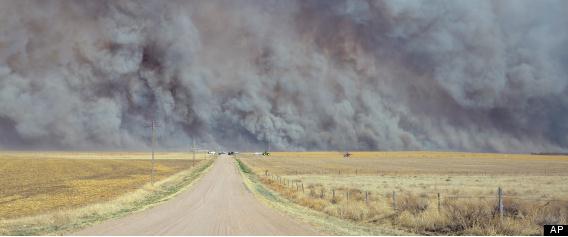
Guest Opinion: Global Warming Makes Firefighting More Dangerous.
The Billings Gazette has an Op-Ed that caught my eye; here's the intro: "
As
former Montana smokejumpers we are increasingly alarmed by the
severity, size, and expense of wildfires. The weather this year in
Montana might give false hope to those who think weather and climate are
the same. But climate is about trends and scientists say that those
trends are proving what our guts have told us for a long time: Climate
change is an increasing problem for firefighters who are facing
increasing risks as a result. Since the 1980s, Montana’s wildfire season
increased by two months while average global temperatures have steadily
trended upward. Climate researcher Steve Running has summarized the
data this way: “Since 1986, longer, warmer summers have resulted in a
fourfold increase of major wildfires and a sixfold increase in the area
of forest burned, compared to the period from 1970 to 1986...” (File photo above: AP).


No comments:
Post a Comment