MN Fall Colors
I want to thank my good friend Nicole Maria Field for the picture below, which shows the incredible fall color in the Twin Cities right now! Just based on what I see, I think we're seeing peak color in the Twin Cities right now! Enjoy it because it won't be long before all the leaves are gone... Breezy winds on Friday will have quite a few of those leaves blowing around.

Atmospheric Time-Out
By Paul Douglas
By Paul Douglas
Wonder if a daily weather column would work in San Diego or Maui? Probably not. The weather doesn't vary much, unless there's a major El Nino in the Pacific, or a Category 1 hurricane pushing toward Hawaii.
Hurricane Ana is about to shake up tropical paradise; a Category 1 force storm set to impact the Big Island and Oahu from late Friday into Sunday night.
It's been the quietest hurricane season in the Atlantic since the early 80s. Just as we were about to write off the season Hurricane Gonzalo may swipe Bermuda with 100-120 mph winds by Friday. Yes, there's a good reason why beachfront hotels are often discounted in autumn, during peak hurricane season. Feeling lucky?
MEA means a 4-day weekend for many families and Thursday is the best day to sneak outside as the mercury brushes 70 degrees. An outrageously nice Thursday gives way to a reality check Friday; gusty winds behind a cool front - the best chance of PM showers up north.
Skies clear Saturday; a stray shower Sunday, but no widespread rain until next Thursday. A jacket-worthy weekend gives way to Indian Summer next week; another taste of 60 degrees by midweek.
No bugs, no pollen and no storms with names.
==============
WEDNESDAY NIGHT: Clear and cool. Low: 41
THURSDAY: Pinch me. I must be dreaming. Warm sun - feels like early September. High: 70. Winds: SE 5-10.
THURSDAY NIGHT: Mostly clear. A little warmer. Low: 50.
FRIDAY: Mostly cloudy, windy & cooler. PM shower (mainly up north). High: 56
SATURDAY: Plenty of cool sunshine. Wake-up: 39. High: 53
SUNDAY: Clouds increase, stray shower late. Wake-up: 37. High: 57
MONDAY: Blue sky returns. Wake-up: 44. High: 59.
TUESDAY: Indian Summer. The Sequel. Wake-up: 45. High: 62
WEDNESDAY: Partly sunny, still very nice! Wake-up: 46. High: 64
==============
This Day in Weather History
October 16th
October 16th
1996: Early evening storms produced 3/4 to 1 3/4 inch hail in Nicollet, Dakota, Brown, Watonwan, and Martin Counties. In Scott County near St. Patrick, hail fell intermittently for an hour and the area received 3 1/2 inches of rainfall. In Watonwan County, wind gusts up to 63 mph moved several garages off their foundations, destroyed a Cattle shed and a corn crib, and uprooted and toppled trees. Southwest of Lake Crystal in Blue Earth County, a garage was blown over onto a vehicle. A 250 gallon fuel tank was also blown over.
1937: Snowstorm leaves 10 inches at Bird Island.
1880: Earliest blizzard in Minnesota. Struck western Minnesota and the eastern Dakotas especially hard. Over a foot of snow in western counties. Railroads were blocked. Damage done to Great Lakes shipping. Huge drifts exceeding 20 ft formed in the Canby area lasted until the next spring when flooding occurred across the Minnesota River Valley.
==============
Average High/Low for Minneapolis
October 16th
October 16th
Average High: 58F (Record: 86F set in 1938)
Average Low: 40F (Record: 23 set in 1952)
Average Low: 40F (Record: 23 set in 1952)
===============
Sunrise/Sunset Times for Minneapolis
October 16th
October 16th
Sunrise: 7:30am
Sunset: 6:27pm
==============
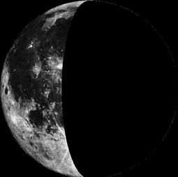
Moon Phase for October 16th at Midnight
1.5 Days After Last Quarter
1.5 Days After Last Quarter
================
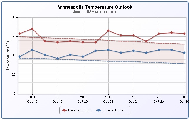
Minneapolis Temperature Trend
No doubt we've entered a more Fall-like weather pattern with temperatures consistently topping out in the 50s and 60s. Fall color are showing up all over the metro and brisk winds have you reaching for that extra layer before heading outdoors. Overnight lows and dipped into the 30s several times around the metro with reports of patchy frost a few times in the outlying suburbs as well. The temperature trend ahead shows a fairly decent day on tap for us on Thursday with temperatures several degrees above average, but it's short-lived as we dip into the 50s over the weekend/early next week. However, extended model runs suggests a chance of getting back into the 60s (above average) by the 2nd half of the month.
===============
Thursday Weather Outlook
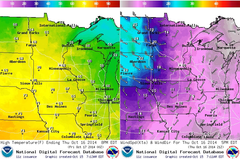
Thursday will be one of the nicer/warmer days of the week with highs approaching 70F in spots across the southern half of the state. Enjoy it because temperatures quickly take a nose dive post cold front that will swing through late Thursday. The images below show temperatures warming ahead of the cold front, which is evident on the wind map (bottom right); note the wind switch from south to west/northwest and increasing. Post front, temperatures will drop into the 50s with breezy winds on Friday.
Weather Outlook
A fairly strong storm system responsible for strong to severe storms earlier this week across the central and eastern part of the country will continue to push northeast through the end of the week. The actual area of low pressure will wobble slightly northwest and bit, which will help to keep cool conditions in place across the northeast quadrant of the nation, especially around the Great Lakes through early next week.
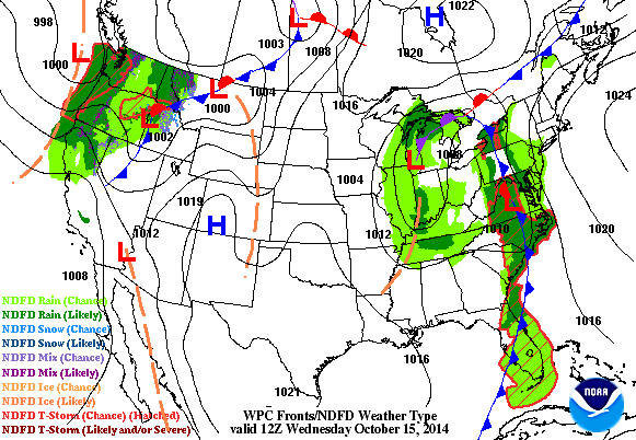
Strong October Storm
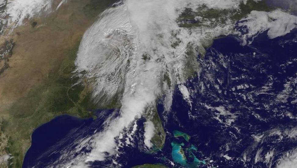
It's not all that unusually to start seeing strong Fall storms at this time of the year. As daylight continues to dwindle across the Northern Hemsiphere, the cold air reservoir near the North Pole continues to build and intensify. This increase in cold air near the pole tends to increase the temperature gradient from north to south, which in turn help to strengthen the upper level winds. As the temperature gradient and upper level wind increases, more intense areas of low pressure develop, which is the atmosphere's way of trying to balance everything out. Storm systems tend to push warm air north and cold air south, but the clash between these to different air masses generally bring wild weather. The image below shows the latest storm system that blew through the central and eastern U.S. with heavy rain and severe weather. Note the 'comma' shape to the clouds; this is indicative of a mature storm system!
Severe Weather Reports
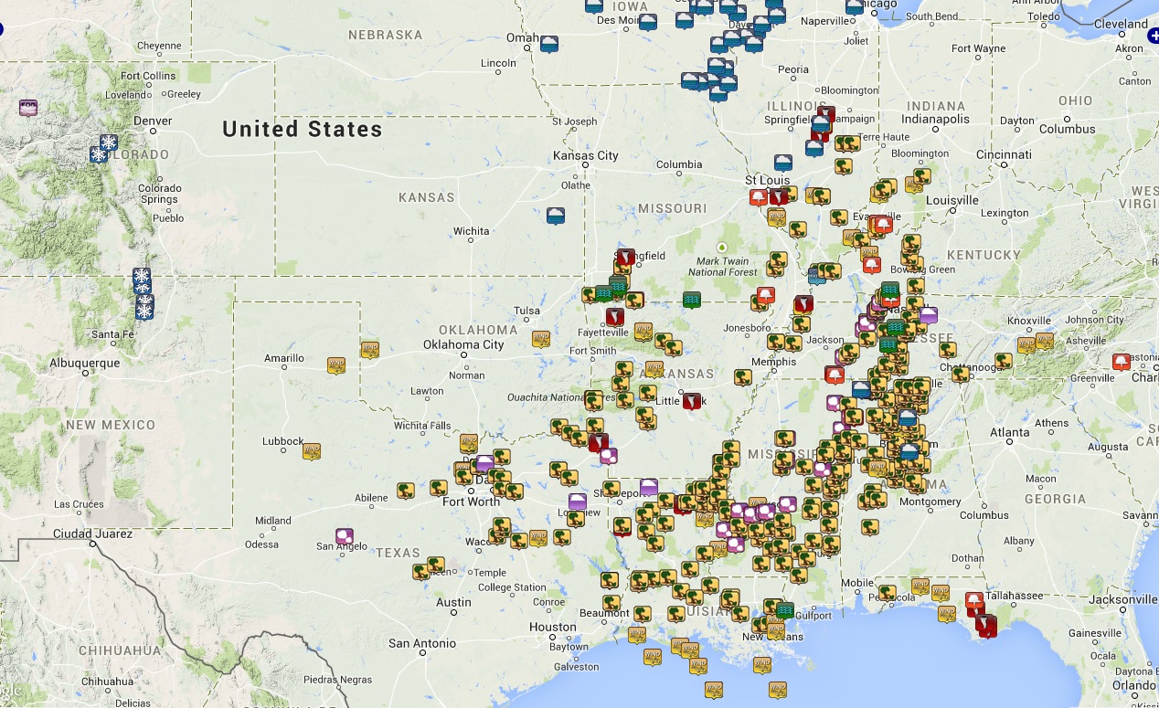
The first half of the week was quite active in the central U.S. - the image below suggests all the preliminary storm reports that occurred; from snow in the Rockies to tornadoes in the central U.S., it was very busy. Unfortunately, 2 people died and several injuries occurred as a result of the storms on Monday.
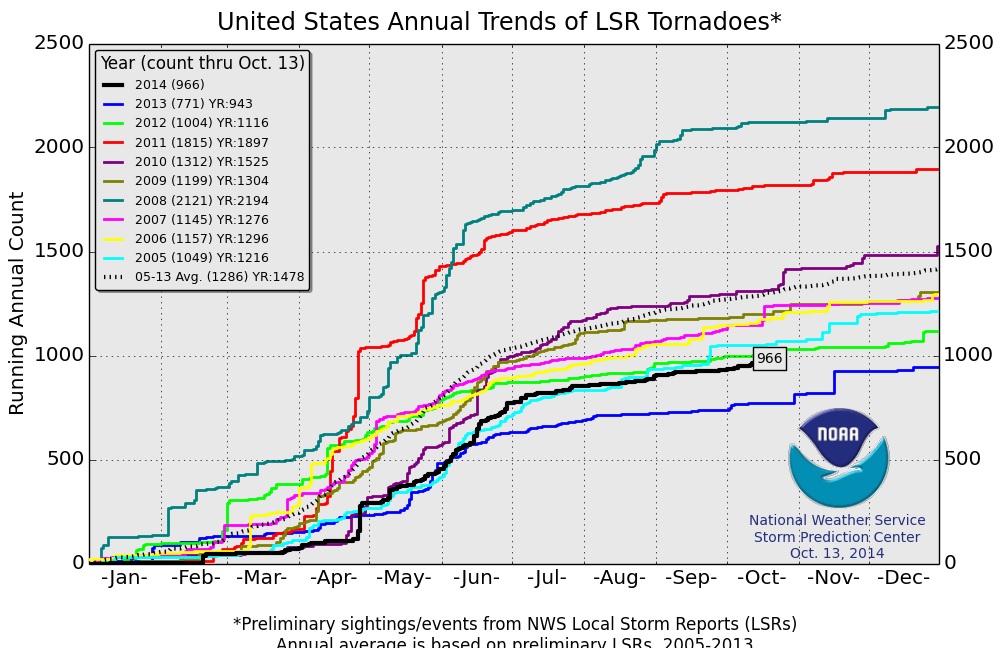
2014 PRELIMINARY Tornado Count
According to NOAA's SPC, the 2014 PRELIMINARY tornado count suggests that there have been 966 preliminary tornado reports so far this year through October 13th. Interestingly, there has only been one other year (since 2005) that has had fewer tornadoes to date, that being 2013 with only 771 tornado reports through October 13th.
More Tornado Stats...
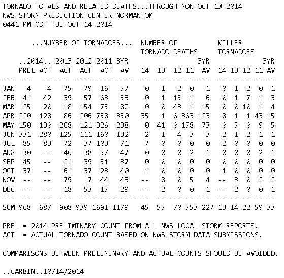
Here's another look at the 2014 tornado stats from NOAA's SPC. Interestingly, there have been 45 tornado deaths this year in 13 different tornadoes.
Second Severe Weather Season
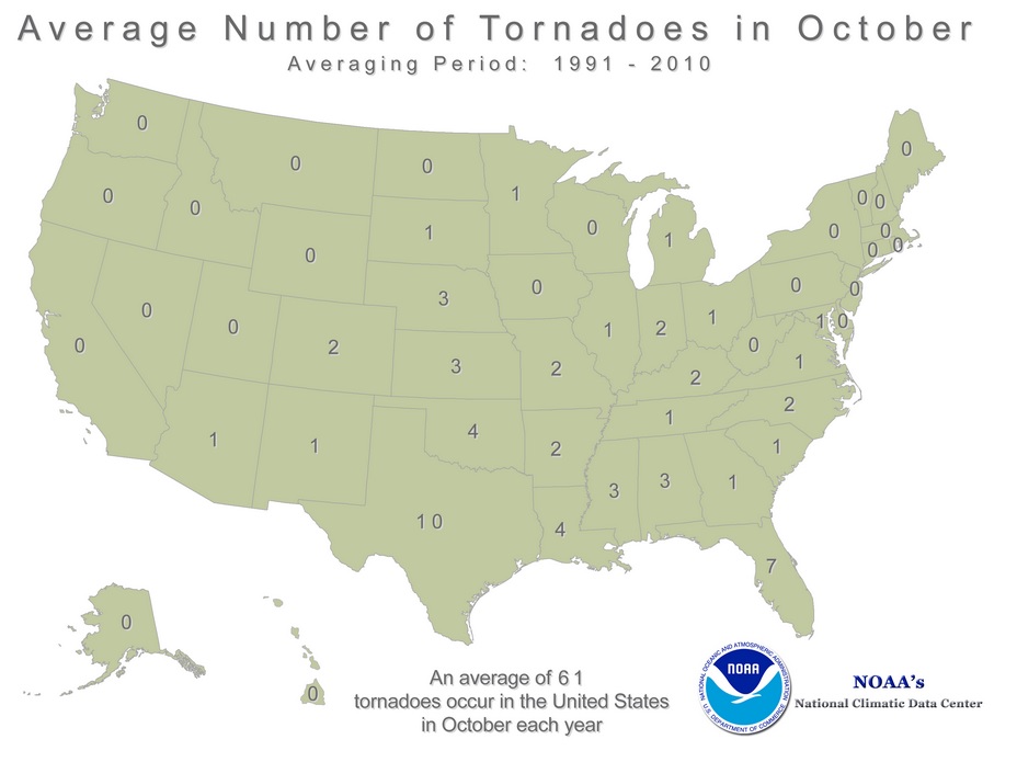
Although you would think severe weather this late in the year may be a bit strange, it's really not! There is in fact a documented secondary severe weather season for places near the Lower Mississippi Valley, Ohio/Tennessee Valley and in the Gulf Coast States. Due to an increase in north to south temperature gradient and an increase in the upper level winds, strong storms whip up at this time of the year, which causes more intense, sometimes even tornado producing storms. The image below from NOAA's NCDC suggets the average (1991-2010) number of tornaodes by state for the month of October. Interestingly, even Minnesota averages 1 tornado!
Quiet Weather Ahead
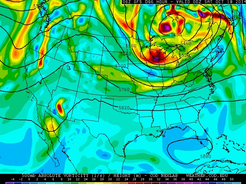
A look at the GFS 500mb vorticity maps through mid week next week shows a void of any major storm systems blowing through the middle part of the country. The image below is the forecast for this Friday, which shows an upper level over Ontario; note that this is part of the same storm that created all the wild weather in the middle part of the country earlier this week. Despite that, a ridge forming across the Rockies/Plains denotes a quieter weather pattern building across the central U.S. over the coming days.
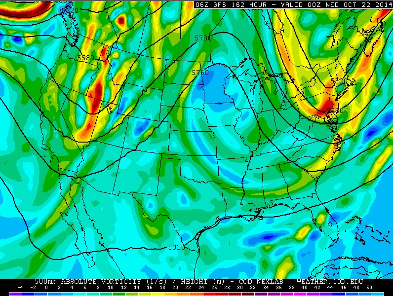
Here's part of that same ridge of high pressure over the Central U.S. into midweek next week. This would represent quiet weather there, which cooler and wetter weather will be found over the northeast and western U.S. next week.
Tropical Update
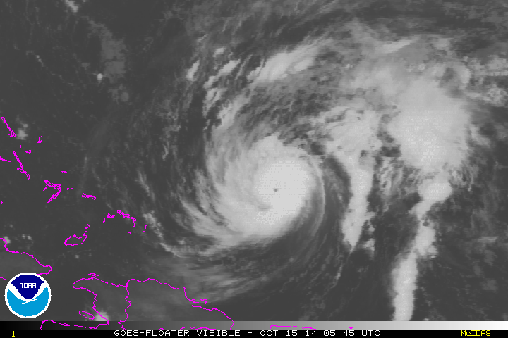
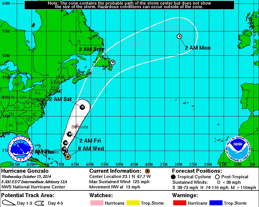
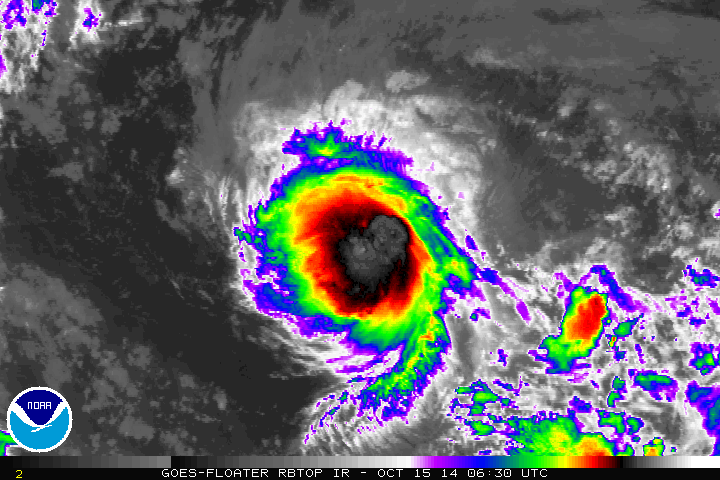
Weather conditions in the Atlantic basin have been heating up as of late. Fay and now Gonzalo have been our latest two named storms from earlier this week, however Gonzalo is the only one left, which as of early Wednesday was a Hurricane! The loop below shows the Wednesday sunrise over Gonzalo, when it was a high end category 3 stormr with sustained winds of 125mph!
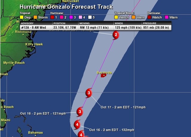
Tracking Gonzalo
According to NOAA's HPC, the forecast track of Gonzalo takes it right over Bermuda by Friday, potentially has a major hurricane!
Tracking Ana
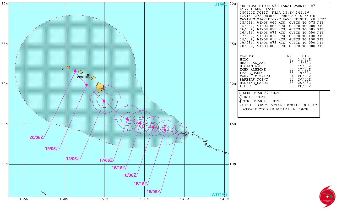
In the Central Pacific, another tropical cyclone named Ana is heading west/northwest on a course that could take it over the Hawaiian Islands later this week/weekend. As of early Wednesday morning, Ana had sustained winds of 70mph and was just below hurricane strength (74mph).
According to the Joint Typhoon Warning Center, the center of Ana will pass south of the Big Island Saturday as a potential high end category one hurricane! This one will be interesting to watch...
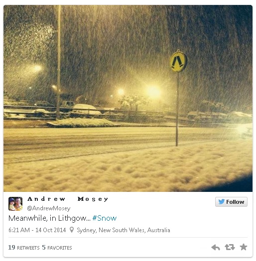
Meanwhile, Down Under...
"A powerful spring storm brought torrents of rain and damaging winds to Sydney, Australia Tuesday night (local time). Meanwhile, its nearby mountains were blanketed by unusual October snow.
The Sydney Morning Herald, which described the storm as “epic”, reports 40 flood rescues from the deluge – mostly due to motorists stranded in standing water. Sydney Olympic Park received 2.5 inches of rain (63 mm) and Canterbury, a suburb just 6 miles to the southwest, nearly twice that amount, the Herald said."
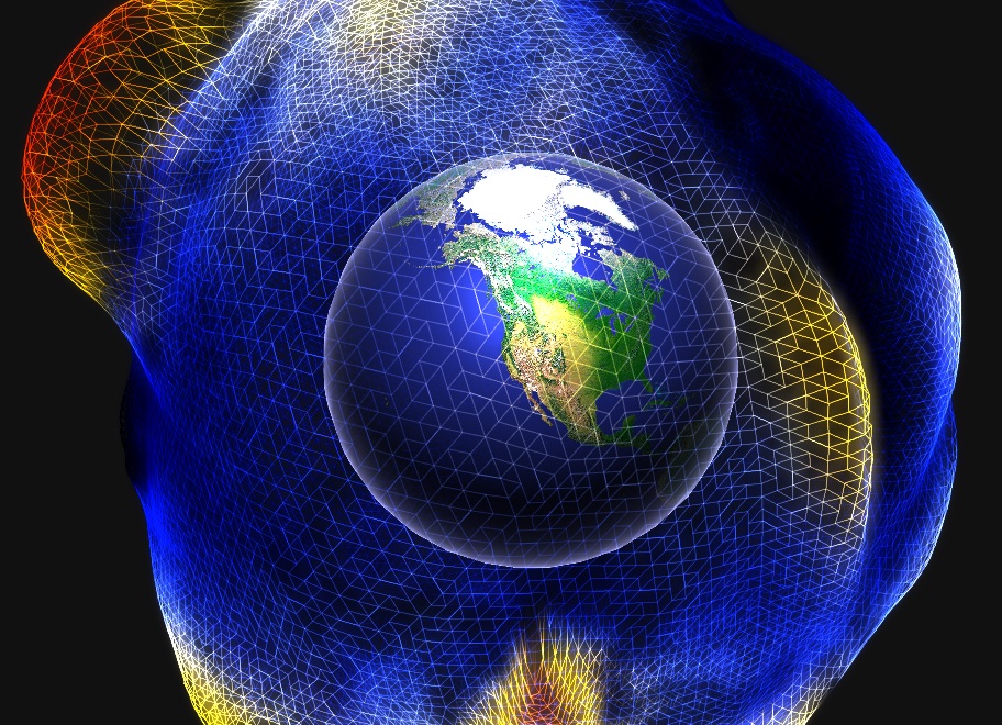
Global Temperature Anomalies
Here's a cool visulaization of global temperatures anamolies...
Thanks for checkin in and have a great rest of your week. Don't forget to follow me on Twitter @TNelsonWX

No comments:
Post a Comment