Snowed In!
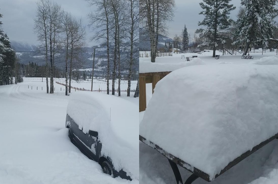
Thanks to an extended family member of mine out of Sparwood, British Columbia for the picture below. Jenna Jensen sent me this picture on Saturday morning and mentioned that they went from having no snow on the ground to THIS in less than a 24 hour period! YIKES!! Jenna mentioned that most roads were closed and she hoped that they were going to be plowed out before the day was done!
In Praise of Freezing
By Paul Douglas
By Paul Douglas
Freezing, a modest 32 degrees Fahrenheit, is considered "frigid" across much of the USA. In Minnesota freezing is a high-five-worthy warm front most of winter. Our coldest days tend to be sunny, which helps us cope with battery-draining air that would horrify most mortals. A lack of oceans over Canada means a fresh supply of dry air. Your skin may feel like tree bark but a lack of moisture in the air helps us survive the chill. 32F feels much worse in Chicago, Boston and Seattle than it does here. Consistently higher humidity channels the chill more efficiently; the cold cuts right through you in cities near large bodies of water.
The atmosphere will shift gears as we push into December; more frequent puffs of Pacific air capable of keeping us in the 30s - perhaps a few degrees milder than average. An extended thaw is 5-10 days away and something to look forward to, but the 72 hour outlook calls for aerobic shivering. Monday is the coldest day; by the end of the week it may be 25 degrees milder, with a little ice Thursday and fog next weekend. Ground fog, as snow begins to melt over time.
It should be getting colder - but the maps consistently hint at moderation in December.
=================
SATURDAY NIGHT: Mostly cloudy. Low: 13. Winds: Turning NW 5-15mph
SUNDAY: MUCH colder with bitter winds, feels like -5. High: 15 (falling to 10 by early evening). Winds: NW 10-20mph.
SUNDAY NIGHT: Mostly clear and COLD! Feels like -15. Low: -2. Winds: NW 10-15mph.
MONDAY: Numbing sun, less wind. Feels like -10F. High: 10. Winds: NW turning S 5-10.
TUESDAY: Breezy, increasing clouds. Wake-up: 6. High: 27
WEDNESDAY: Blue sky, still chilly. Wake-up: 7. High: 20
THURSDAY: Milder, minor icing possible. Wake-up: 14. High: 29
FRIDAY: Mostly cloudy, feeling better. Wake-up: 24. High: 33
SATURDAY: Partly sunny, nice to be average. Wake-up: 25. High: 32
==================
This Day in Weather History
Novebmer 30th
Novebmer 30th
2000: A surface low pressure system which moved over extreme southwestern Minnesota from South Dakota, continued southeast into northern Iowa during the evening hours on the 30th. The heaviest snow reported was in the 6 to 8 inch range, and fell in a narrow band just southwest of the Minnesota River in and around the Canby(Yellow Medicine County) and Madison(Lac Qui Parle County) areas. Northeast winds rising out of the Minnesota river valley up the slopes of the Buffalo Ridge in southwest Minnesota helped enhance snowfall amounts. The northeasterly winds between 10 and 20 mph were responsible for producing visibilities in the one to two mile range.
1991: A storm dumps 14 inches in the Twin Cities in about 12 hours.
1896: Quite chilly across Minnesota. 45 below zero at the Pokegama Dam.
===================
Average High/Low for Minneapolis
November 30th
November 30th
Average High: 33F (Record 62F set in 1922)
Average Low: 18F (Record -17F set in 1964)
Average Low: 18F (Record -17F set in 1964)
===================
Sunrise/Sunset Times for Minneapolis
November 30th
November 30th
Sunrise: 7:29am
Sunset: 4:33pm
Sunset: 4:33pm
==================
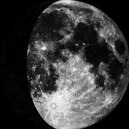
Moon Phase for November 30th at Midnight
1.9 Days Since Moon Phase
1.9 Days Since Moon Phase
=================
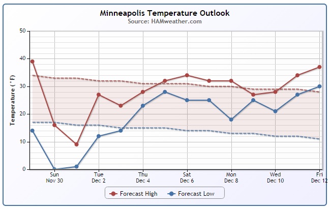
Minneapolis Temperature Trend
After a comfortably mild Saturday, temperatures will take a BIG hit late weekend/early next week with the passage of a fairly potent cold front. Keep in mind that we won't see much precipitation with this front, but as we approach the first day of Meteorological Winter (Monday, December 1st) - it'll feel much like winter!
======================
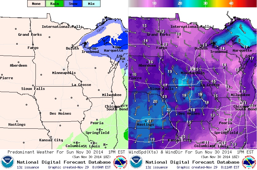
Sunday Weather Outlook
A fairly potent cold front will swing through the Upper Midwest late Saturday/Sunday and drop temperature readings rather significantly. Note that highs across the northern part of the state will only be in the single digits with feel like temperatures in the teens & 20s below zero by early afternoon! In fact, feels like temperatures in the Twin Cities could be sub-zero by midday as well! Keep that in mind if you're heading to the Vikings game at TCF Bank Stadium... you'll definitely need some extra layers to battle the bone-chilling wind.
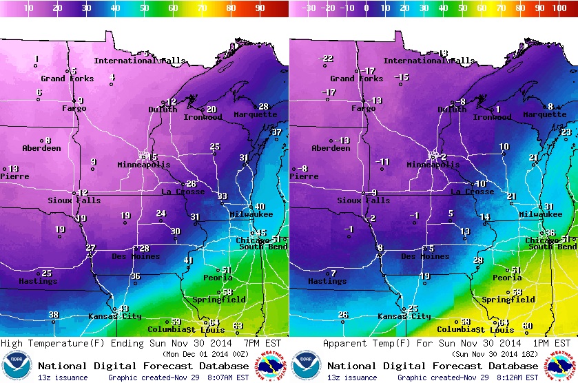
Sunday Weather Outlook Continued...
Cold winds will follow the front through the Upper Midwest on Sunday with wind gusts up to 20-25mph. Unfortunately, with temperatures as cold as they're expected to be, wind chill values will be quite bitter through early next week with with the slightest breeze.
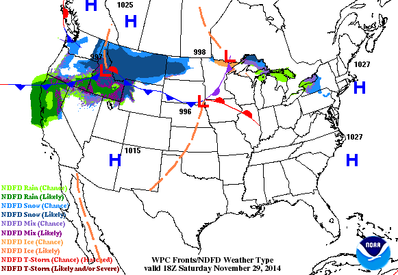
National Weather Outlook
Note the cold front sweeping through the middle part of the country through early next week. The big blue "H" behind it is a large area of Arctic high pressure. Temperatures will be significantly colder late weekend/early next week than what we had on Saturday. Precipitation becomes a little more pronounced on Monday from the Eastern Great Lakes through the Ohio Valley and Lower Mississippi Valley, however temperatures should be warm enough for mostly liquid precipitation with a few exceptions closer to the Great Lakes. Another area of interest continues in the Western U.S. as moisture continues to blow in from the Pacific. Heavy snowfall in the Rockies and heavier coastal rains in central and southern California will taper a bit by early next week before another round of heavier Pacific moisture swings in again by the middle part of next week!
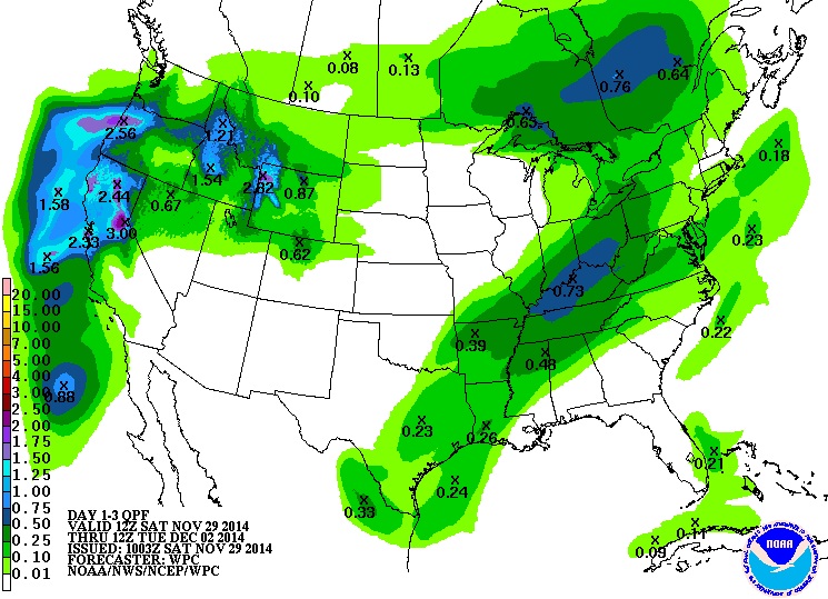
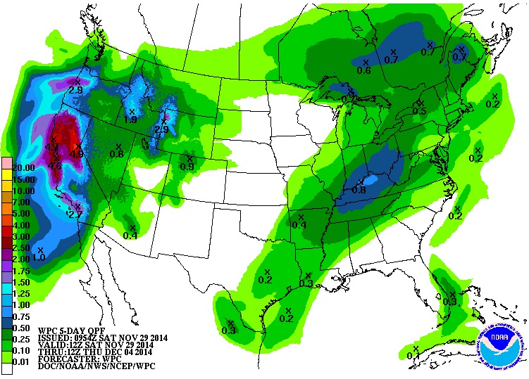
Precipitation Outlook: AM Saturday - AM Tuesday
According to NOAA's HPC, the precipitation outlook from AM Saturday to AM Tuesday looks fairly soggy across part of the West Coast, especially along in the coastal communities and in the higher elevations.
Precipitation Outlook: AM Tuesday - AM Thursday
As we approach midweek, another round of heavier precipitation will move into the Southwest with the heaviest precipitation acorss California... a sight for sore eyes! Keep in mind that some of this moisture will be in the form of heavy snow across the higher elevations! It appears that this could be one of our first big storms of the season!
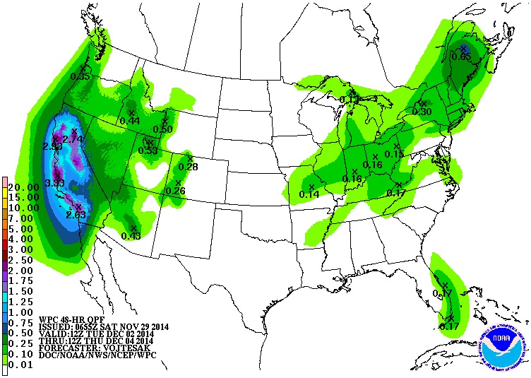
Precipitation Outlook: AM Saturday - AM Thursday
According to NOAA's HPC, the 5 day total precipitation across the West Coast could approach nearly 5" in spots near the coast and across the higher elevation of the central and northern portions of the Sierra Nevada range. It is possible that parts of the Sierra Nevada Range could wind up with nearly 2ft. of snow or more by the end of the week. Even those in the higher elevations surrounding Los Angeles and the San Bernardino Mountains could see several inches of precipitation by the end of the week, however most of that moisture may fall in the liquid form... flooding could become an issue there.
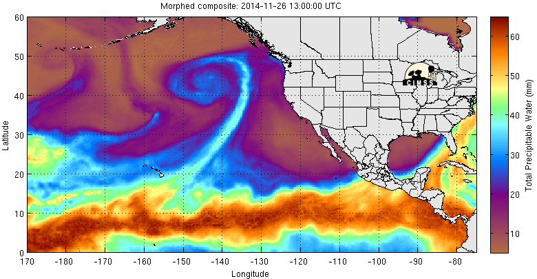
Why So Much Western Moisture?
Note the blue line that extends from near Hawaii to the Pacific Northwest early in the loop... this feature is known as an "Atmospheric River" and typically when this feature sets up, parts of the West Coast can get slammed with heavy precipitation. A strong area of low pressure and stronger atmospheric winds can help carry quite a bit of moisture over a long stretch of ocean to its destination in the western U.S. This feature is also known as the "Pinneapple Express"
Temperature Outlook Ahead
It appears that we'll have a VERY cold start to the work week (first full week of December and Meteological Winter), but we quickly warm through the week and most of us will at or slightly above average by the end of the week! Take a look at the images below...
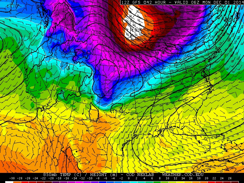
850mb Temperatures AM Monday
An Arctic air mass will sag south of the international border through the early week time frame with MUCH below average readings. The coldest weather will be with us on Monday as temperatures struggle to get to freezing (32F) in many areas across the Upper Midwest.
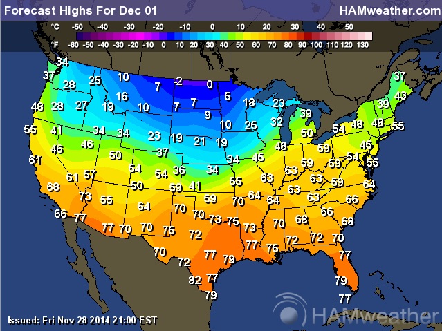
High Temperatures Monday
Some forecasts call for sub-zero daytime highs across parts of northern North Dakota! YIKES!! You can bet that wind chill values will be even colder, so bundle up!
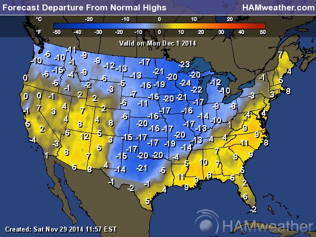
Highs From Average Monday
The Arctic air invasion is quite evident on the highs from normal map below. Note the sharp line from Texas to the Eastern Great Lakes region... temperatures behind the front will be nearly 10F to 20F BELOW average!
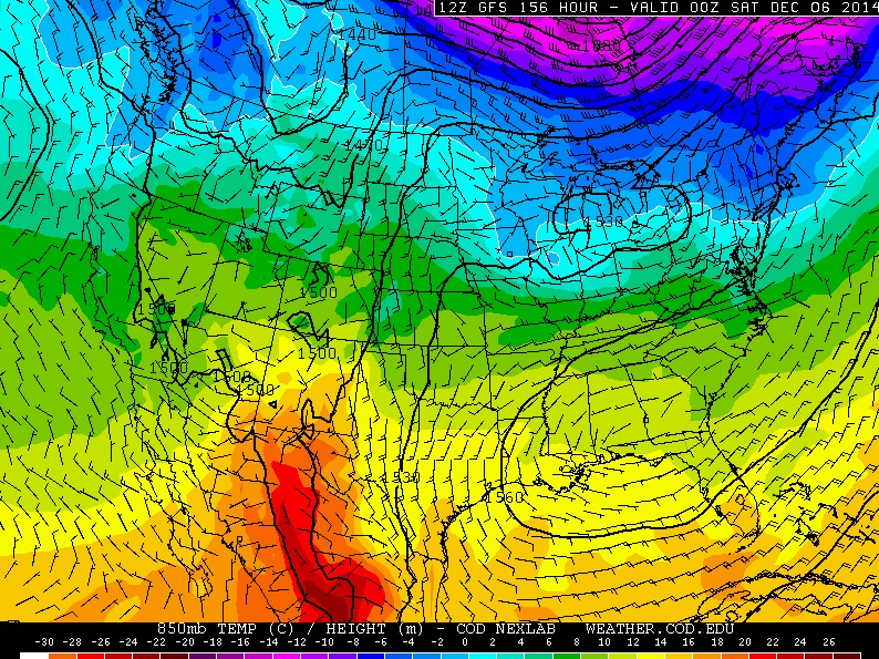
850mb Temperatures Friday
The good news is that the extreme cold should be fairly short-lived. Temperatures look to warm steadily through the week and by Friday, much of the Arctic air looks to be north of the international border!
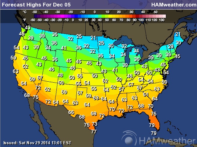
High Temperatures Friday
Sure, it'll still be a bit chilly on Friday across the northern tier of the nation, but it won't be nearly as cold as it will be early in the week. In fact, temperatures could crack the freezing mark once again, which would lead to more snow melt/fog in some areas.
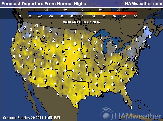
Highs From Average on Friday
If you're not a fan of extreme cold, maybe the golden hues in the map below will improve your outlook of early December. It appears that much of the nation will be at or slightly above average with only a few exceptions near the border in the Northwest and Northeast.
Warmer Temperature Outlook Through Early December
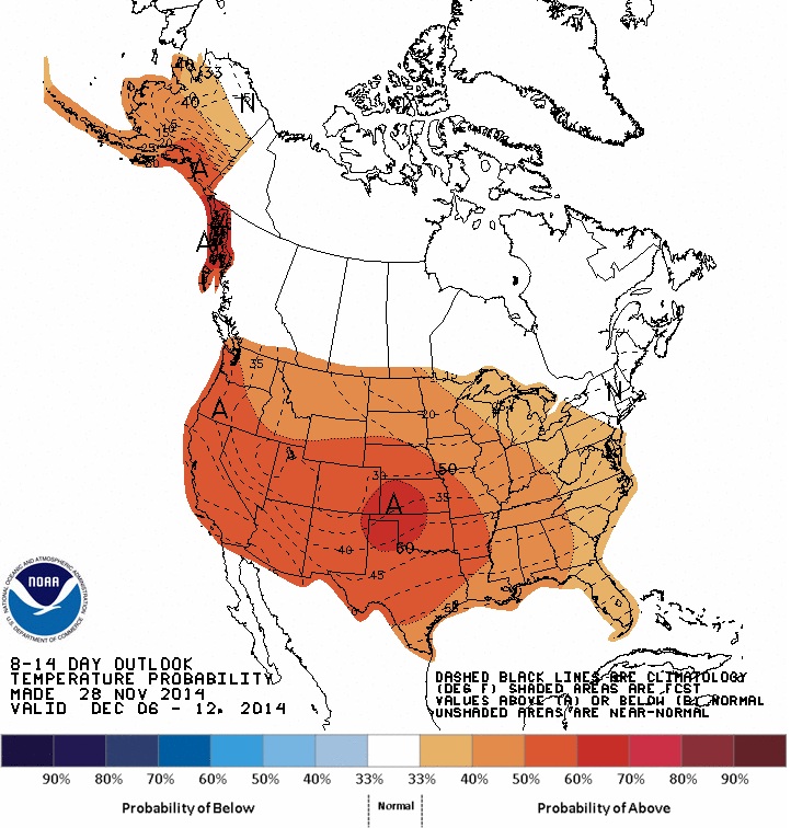
After the cold November that we had, I thought we'd be in for a very long, cold and snowy winter with as soon as it seemed to be starting this year, but extended model runs through mid December look a little better. According to NOAA's CPC, the 8 to 14 day temperature outlook shows a fairly good chance of above/well above average temperatures across much of the nation!
2014 U.S. Tornado Reports
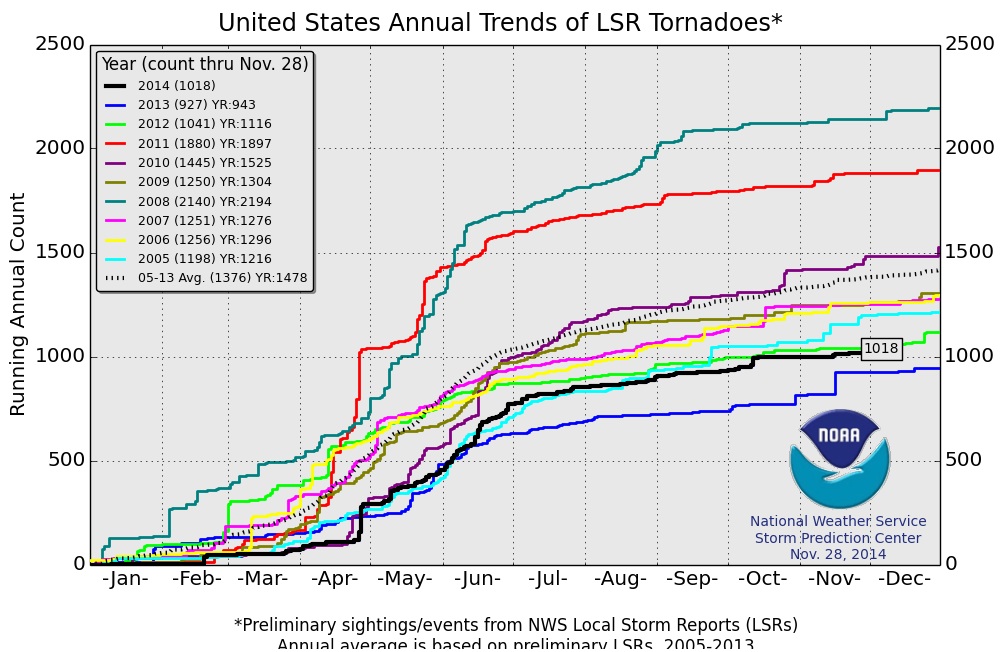
According to NOAA's SPC, the national 2014 PRELIMINARY tornado report data suggets that there have been a little more than 1,000 tornado reports. Looking at the data from 2005-2014 below, through November 28th, 2014 has seen the second lowest number of preliminary tornado reports only behind last year (2013 with 927 reports). The 2005-2013 average is 1,376 through November 28th, so we are a bit behind the short-term average.
2014 Minnesota Severe Weather
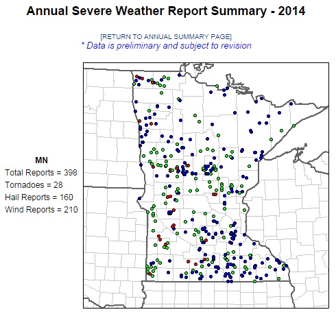
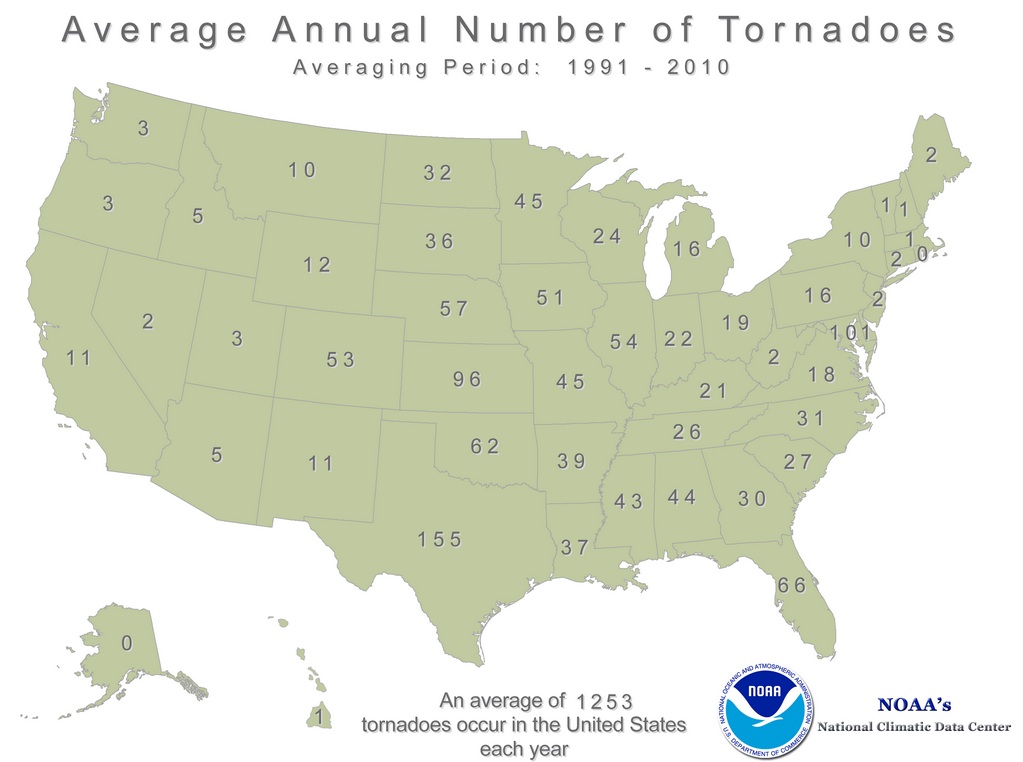
According to NOAA's SPC, Minnesota has seen just shy of 400 PRELIMINARY severe weather reports including hail, high winds and tornadoes. There have only been 28 tornado reports in Minnesota this year, which according to NOAA's NCDC is below the annual average of 45 (1991-2010).
Balloon POP at 102,986ft.
Here's a neat story from Spacweather.com about a balloon that was launched into the stratosphere to collect data on cosmic radiation levels in the Earth's ozone layer. If nothing else, the pictures are quite impressive!
"SPACE WEATHER BALLOON EXPLODES: On Nov. 23rd, the students of Earth to Sky Calculus launched a Space Weather Buoy to the stratosphere. Carried aloft by a suborbital helium balloon, the payload contained a pair of X-ray/gamma-ray sensors to measure cosmic radiation levels inside Earth's ozone layer. About 90 minutes after launch, this is what happened:"

Thanks for checking in and have a great first full week of December ahead! Don't forget to follow me on Twitter @TNelsonWX

No comments:
Post a Comment