See more of Dennis' great photography HERE: http://www.northernimages.com/
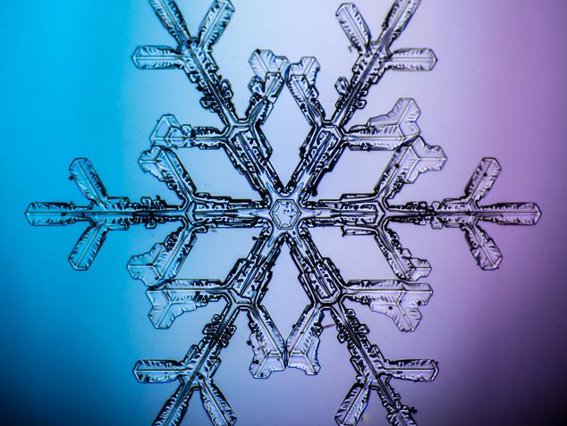
No Two Snowflakes Are Alike...
Dennis O'Hara does it again! Take a look at these stunning images of individual snowflakes through a microscope! It really is amazing when you look at how unique the structure of a snowflake really is.
See more from NorthernImages.com HERE:
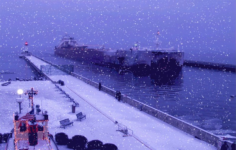
Fleeting Thaw
By Paul Douglas
"Winter is the season in which people try to keep the house as warm as it was in the summer, when they complained about the heat." Yes, we love to complain about our meteorological fate. Some days it's hard getting to acceptance.
After a few premature stabs of winter, November temperatures nearly 9F colder than average, with the 6th coldest Thanksgiving morning on record, the pattern is about to shift gears. After one more numbing smack Sunday and Monday steering winds 4-8 miles overhead will morph from northwest to more westerly, blowing in from the Pacific, instead of frozen Manitoba. Translation: for some set period of time Canada will (temporarily) run out of cold air.
Long range guidance is hinting at 30s, even a few 40s from late next week into mid-December. The mysterious January Thaw may show up 3 weeks early. Storms? The pattern won't be ripe for significant snow anytime soon. Our upcoming Pacific thaw will melt considerable snow 1-2 weeks from now. A white Christmas isn't a foregone conclusion this year, believe it or not.
With El Nino kicking in (finally) all bets are off for the rest of this winter. But I still suspect it won't look anything like last winter.
==============
FRIDAY NIGHT: Lingering clouds. Low: 24. Winds: SE 5mph
SATURDAY: Patchy clouds, welcome thaw! High: near 40. Winds: S 10mph
SATURDAY NIGHT: Mostly cloudy. Low: 18. Winds: SW turning NW 5-15mph
SUNDAY: Mostly cloudy, much colder wind. High: 27 (falling to 15 by early evening).
MONDAY: Sunny, less wind. Feels like -10F. Wake-up: -3. High: 9
TUESDAY: Breezy, slight warm up. Wake-up: 6. High: 25
WEDNESDAY: More sun, less wind. Wake-up: 8. High: 24
THURSDAY: Flurries, freezing drizzle. Wake-up: 12. High: 35
FRIDAY: Mostly cloudy, feeling better. Wake-up: 31. High: 40
==============
This Day in Weather History
November 29th
1991: Parts of central Minnesota received heavy snow including a record 16 inches of snow in New Ulm.
1835: 11 below zero at Ft. Snelling.
===============
Average High/Low for Minneapolis
November 29th
Average High: 33 (Record 62 set in 1998)
Average Low: 19 (Record -25 in 1875)
===============
Sunrise/Sunset Times for Minneapolis
November 29th
Sunrise: 7:28am
Sunset: 4:34pm
==============
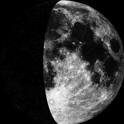
Moon Phase for November 29th at Midnight
0.9 Days After First Quarter
==============
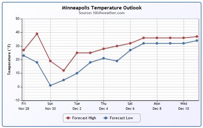
Minneapolis Temperature Trend
After a very brief thaw on Saturday, temperatures take a big hit late weekend/early next week. Wind chilly values then will be quite raw, but we climb out of the face-numbing cold gradually through the week ahead. We'll have no problem flirting with freezing mark by next weekend and potentially even into the 2nd week of December.
=======================
Saturday Weather Outlook
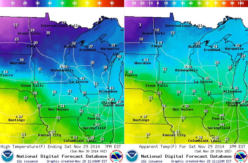
Temperatures on Saturday will feel quite warm after the cold weather we experienced over the last couple of days. We'll actually climb above the freezing mark in many locations and perhaps even get to 40 in the Twin Cities. If your Black Friday sales shopping continues Saturday, it might not be a bad idea to bring some good boots/shoes to slop around in as roads/parking lots will be slushy from the latest clippers that blew through. The images below shows high temperatures (left) and feels like temperatures (right).
Saturday Weather
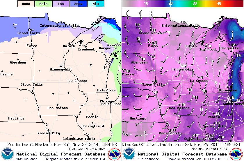
A fairly weak storm system will slide across the international border on Saturday with a little light snow there. Temperatures across much of the state will be out of the south, which in turn will allow temperatures to warm into the 30s to near 40 across the central and southern part of the state. By Sunday, that front will barrel south of us and drag down another bitter air mass. Temperatures on Sunday will fall steadily through the day; by early Sunday evening, it'll feel more like the single digits above and below zero. BRRR!
Snow Potential
Good news for folks that may be traveling (back home) this weekend, there doesn't appear to be any major weather makers blowing through Minnesota or the Upper Midwest. Other than a little light snow across the northern tier of the nation, most locations will stay quiet. The only problem will be MUCH colder temperatures and wind chill values on Sunday into Monday.
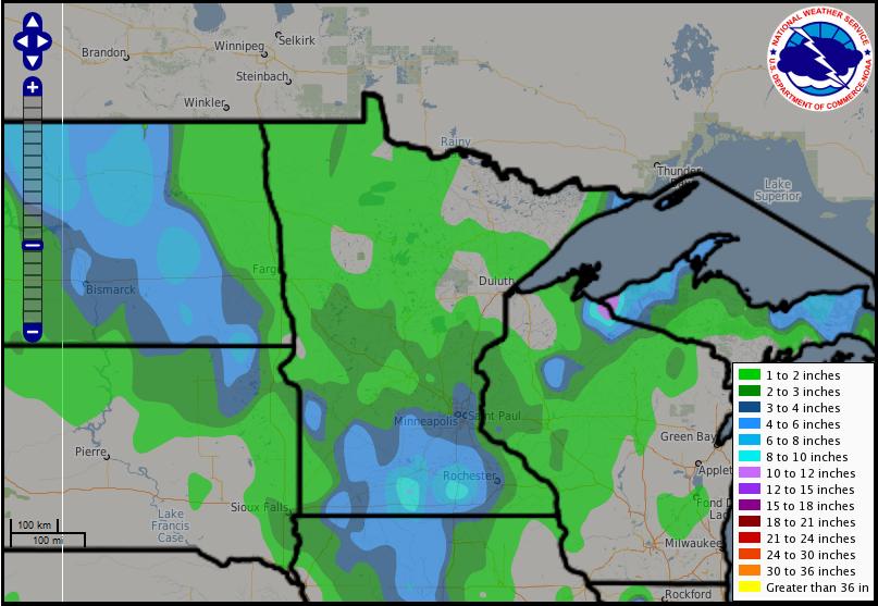
Snow Past 72 Hours
Over the last few days, 2 clipper systems have pushed through region with some light fluffy snow accumulations. The heaviest snow fell with the first clipper on Wednesday across southern Minnesota with up to 11" reported near Faribault, MN.
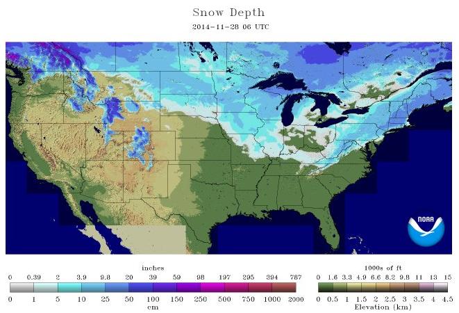
2014 U.S. Snow Cover
As of November 28th, NOAA's NOHRSC suggested that nearly 30% of the nation was covered in snow. The most widespread snow was found across the Midwest and Northeast.
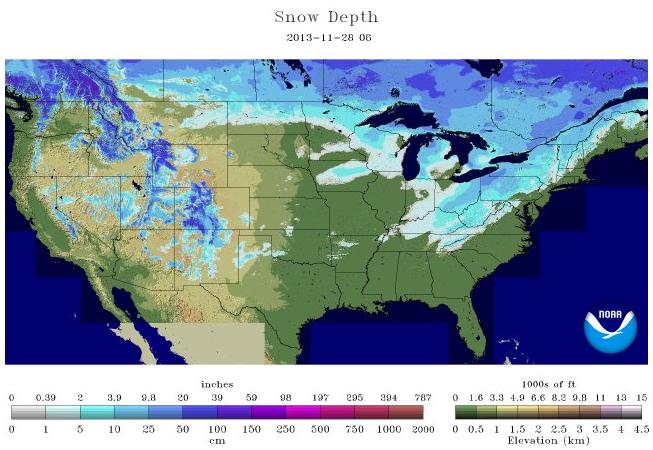
2013 U.S. Snow Cover
Interestingly, at this time last year, there was also nearly 30% snow cover across the nation. However, the most widespread snow was found in the Northeast and across the Rockies. Note how little snow there was across the Midwest.
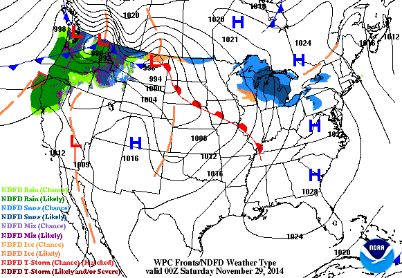
National Weather Outlook
Note the strong cold front blowing through the middle part of the country through the end of the weekend... this will be responsible for a significant cool down into early next week through the Upper Midwest. Moisture associated with it will be limited in the middle part of the country, but heavy moisture will continue west of the Rockies.
Focusing on the Cold Weather
Another bitter blast of cold weather will be heading south of the international border. By AM Monday, temperatures across the Red River will dip into the teens below zero, possibly even close to -20F!

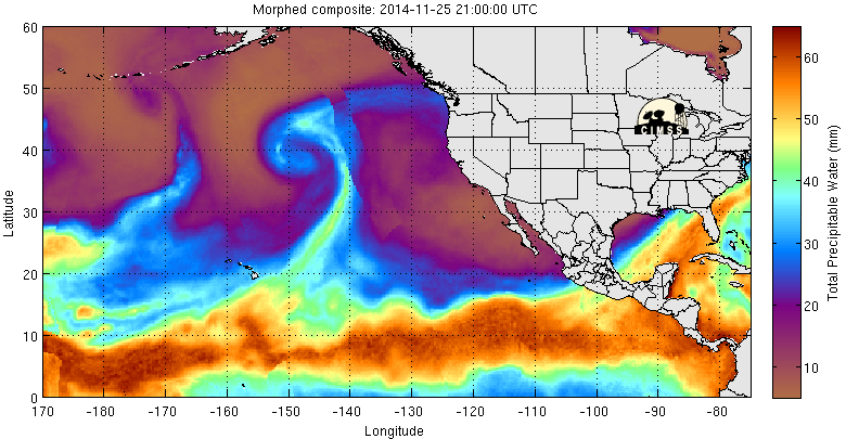
Atmospheric River
Take a look at the plume of moisture, which stretches from the middle of the Pacific to the West Coast. This feature is known as an "Atmospheric River" which often times brings copious amounts of moisture to the West Coast. The upcoming forecast calls for several inches of precipitation over the next 5 days.
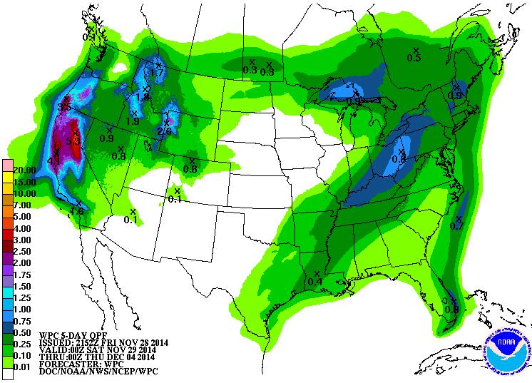
5 Day Precipitation Forecast
Note how much precipitation is forecast through early next week. Some spots in California could see as much as 4" to 5" or more!!
Drought Busting Precipitation?
Despite the heavy precipitation in the forecast over the West Coast, we still have a LONG ways to go. We are still WELL below average precipitation, so hopefully the active weather pattern will continue!
Take a look at the image below from the NWS San Fransisco Area/Monterey California

Star Wars: The Force Awakens
I nearly fainted when I saw this new Star Wars trailer... It looks awesome!! If you haven't heard, there is going to be a NEW Star Wars movie, which opens in theatres NEXT year on December 18th, 2015. Oh man, I can't wait!!!
"After years of wait, it's finally here! The first look at J.J. Abrams' Star Wars: The Force Awakens. It's loaded with new cool stuff: The new version of the X-Wing fighters, new characters, new storm stormtroopers, and one really cool shot of the Millennium Falcon battling TIE fighters over a desert. Watch it!"
See more from Gizmodo HERE:

Thanks for checking in and have a great rest of your weekend. Don't forget to follow me on Twitter @TNelsonWX

No comments:
Post a Comment