Cold Crunch
By Paul Douglas
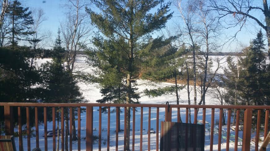
"It is the life of the crystal, the architect of the flake, the fire of the frost, the soul of the sunbeam. This crisp winter air is full of it" wrote John Burroughs in "Winter Sunshine". Look past the thermometer at the magnificent, marble-gray landscape out there. Once I get past the seizure-like spasms of shivering I may even try to snap a few photos.
This latest arctic front isn't making your Monday any easier with a wind chill at the bus stop of 15 to 20 below. This should be as cold as it gets looking out into mid-December.
After a November 8-9 degrees colder than average I don't blame you for being skeptical of a warming trend. "Winter came too early this year; it's an omen of what's to come!" you might think. Not necessarily.
What's different this winter is El Nino. The long-predicted warming of Pacific water should have a moderating influence into spring. We'll still see cold and snow; just not as much of it as last winter.
No big storms are brewing anytime soon; just a Pacific breeze thawing out the tundra from late this week into much of next week. Clouds, fog, a little drizzle, but no more bitter blasts or stormy headaches are looming anytime soon. A break.
===============
SUNDAY NIGHT: Mostly clear and COLD! Feels like -15. Low: -2. Winds: NW 10-15mph.
MONDAY: Numbing sun, less wind. Feels like -15F to -20F. High: 8. Winds: NW turning S 5-10.
MONDAY NIGHT: Mostly clear and cold. Feels Like: -10F to -15F. Low: 3. Winds: SSE 5-15
TUESDAY: Breezy, increasing clouds. High: 26
WEDNESDAY: Blue sky, still chilly. Wake-up: 11. High: 22
THURSDAY: Cloudy with a few flakes. Wake-up: 9. High: 25
FRIDAY: Intervals of sun, feeling better. Wake-up: 23. High: 33
SATURDAY: Patchy clouds, dripping icicles. Wake-up: 21. High: 35.
SUNDAY: More clouds than sun. Wake-up: 27. High: 34.
==================
This Day in Weather History
December 1st
1998: The warmest December day ever in the Twin Cities with 68 degrees. St. Cloud rose to 61.
1985: Parts of central Minnesota received up to a foot of snow. Snowfall totals included 12 inches at Waseca and Milaca, 11.3 at Alexandria, and 11 inches at Fairmont and Long Prairie.
==================
Average High/Low for Minneapolis
December 1st
Average High: 32F (Record 68F set in 1998)
Average Low: 18 (Record -15 set in 1893)
====================
Sunrise/Sunset Times for Minneapolis
December 1st
Sunrise: 7:30am
Sunset: 4:33pm
====================
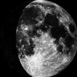
Moon Phase for December 1st at Midnight
1.9 Days After First Quarter
======================
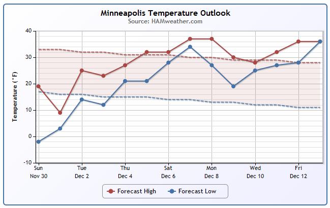
Minneapolis Temperature Trend
It'll be a chilly start to the first week of Meteorological Winter, but it won't take long for temperatures to warm to near average levels by the end of the week. In fact, there's a fairly good chance that we see above average readings by the first weekend of December!
=======================
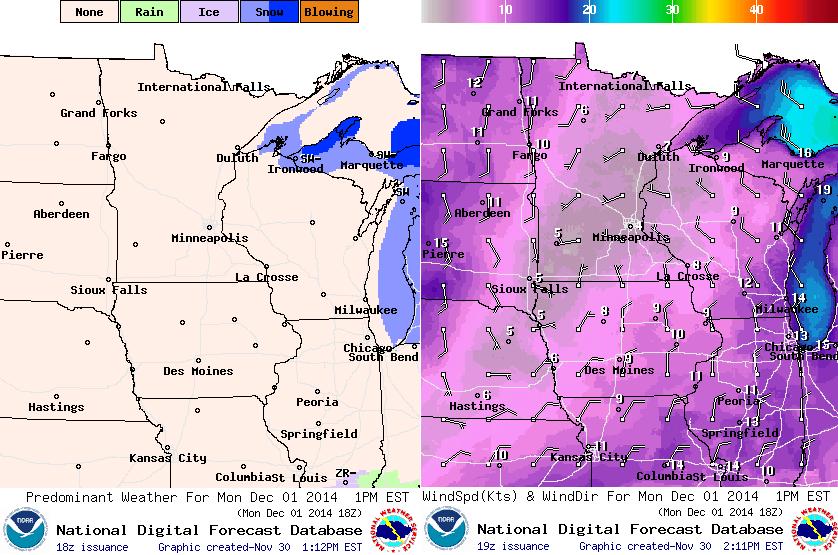
Monday Weather Outlook
Monday will be the coldest day of the week with high temperatures struggling to get into double digits. Some spots across the northern part of the state will have a tough time even getting above the sub-zero range. Wind chill values will likely sub-zero for much of the state Monday with readings as low as the 20s below zero across the northern part of the state.
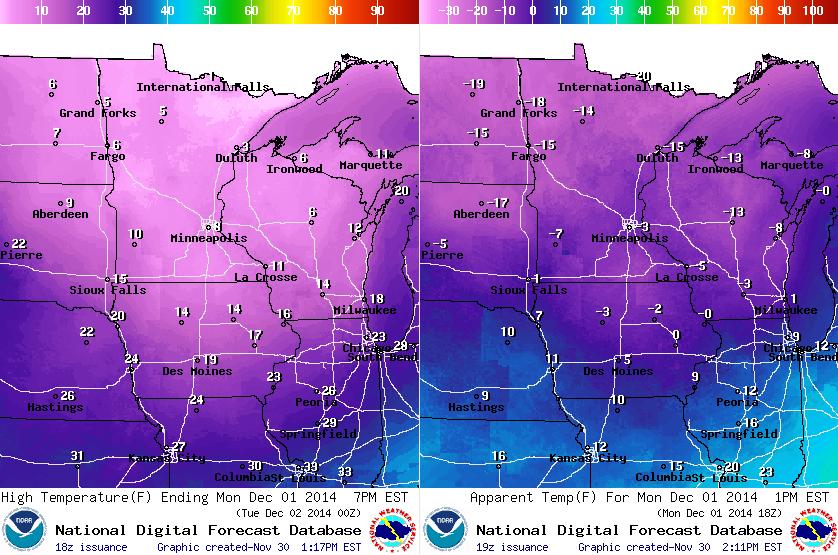
Monday Weather Outlook
Arctic air isn't just very cold, it is very dry, so there typically tends to be lots of sunshine on some of our coldest days. A big bubble of Arctic high pressure settles in on Monday... the bad news is that it'll be extremely cold for the first day of December, but at least the winds will be lighter!
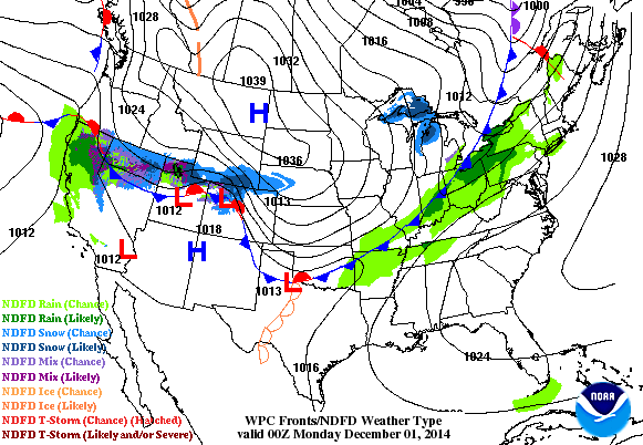
National Weather Outlook
Our cold start to the work week can be attributed by a big bubble of Arctic High pressure, which can be noted by the blue "H" moving across the Upper Midwest. The good news is that the extreme cold shouldn't last too long this week. The other big weather feature through the early week time frame is the heavy precipitation moving into the West Coast/California.
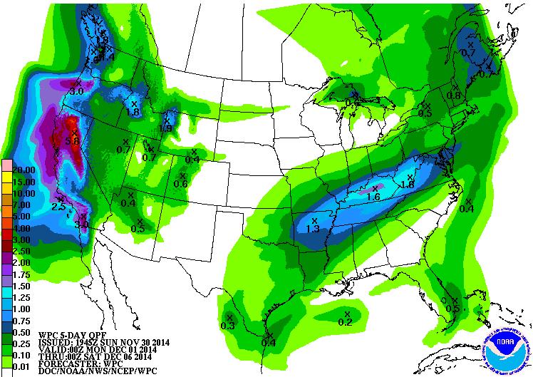
5 Day Precipitation Outlook
According to NOAA's HPC, the 5 day precipitation outlook suggests copious amounts of precipitation moving into the West Coast/California through the week ahead. Some spots could see up to 5" or more, especially in the higher elevations of the Sierra Nevada Range. The higher elevations of southern California could even see several inches of precipitation through the week ahead! My concern is that the heavy precipitation on extremely dry ground could contribute to some flooding issues.
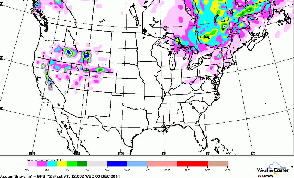
Snowfall Potential
Take a look at the snowfall potential through the next 72 hours, note the heavy snowfall potential across parts of the Sierra Nevada Range. I'm sure the ski resorts are getting excited about the upcoming snow event!
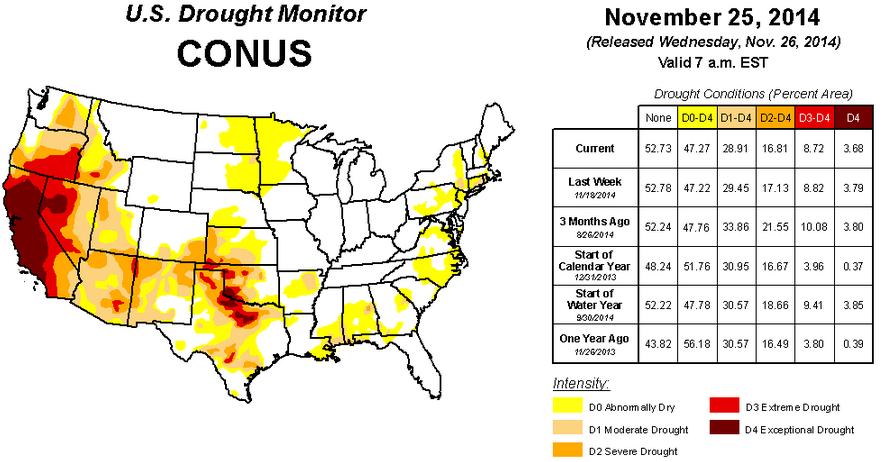
U.S. Drought Monitor
The good news is that the upcoming moisture in the western U.S. is much needed! Unfortunately, we will need a lot more to end the drought. As of November 25th, the U.S. Drought Monitor suggested that nearly 55% of California is considered to be in an EXCEPTIONAL DROUGHT
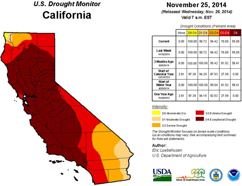
California Drought
2014 has been an exceptionally dry year... note that at the start of the 2014 calendar year, 0% of California was considered to be in an exceptional drought, but now, nearly 55% is considered to be EXCEPTIONALLY dry.
Southern California Rain
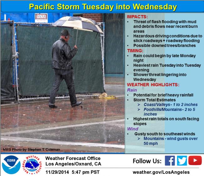
California is set to pick up some MUCH needed precipitation this week, but unfortunately this could lead to some flash flood concerns. Here's the latest from National Weather Service out of Los Angeles/Oxford, CA.
"A pacific storm system will impact Southwest California Tuesday into Wednesday. Rain could begin as early as late Monday night across portions of the forecast area, with rainfall becoming more widespread and heavier on Tuesday into Tuesday evening. A threat of showers will linger into Wednesday. Rainfall totals with this system are generally expected to range between 1 and 2 inches across coastal and valley areas, with foothill and mountain areas generally ranging between 2 and 5 inches. The highest rainfall amounts are expected to be on south facing slopes. The potential for brief heavy rain will bring a threat of flash flooding with mud and debris flows near recent burn areas…as well as potential urban flooding of roadways. In addition, this system will likely be accompanied by gusty south to southeast winds, with gusts over 50 mph possible in the mountains."
"Southern California to see Biggest Storm Since February"
"Get out those rain boots and umbrellas. Forecasters are expecting the biggest rainstorm since February to hit the Los Angeles area.
A Pacific Northwest weather system should bring heavy rains to Southern California starting Tuesday, according to the National Weather Service. Downtown Los Angeles is expected to get 1 to 2 inches of rain, and the San Gabriel Mountains could see up to 2 to 3 inches, said Bonnie Bartling, a weather specialist with the agency.
The storm could produce snow at an elevation of 7,500 feet, she said."
Read more from LATimes.com HERE:
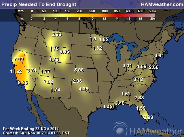
Precipitation Needed to End Drought
The precipitation expected for parts of California is wonderful news indeed, but it certainly won't be enough to end the drought. Here's a look at how much rainfall we would need to even get close at ending the drought...
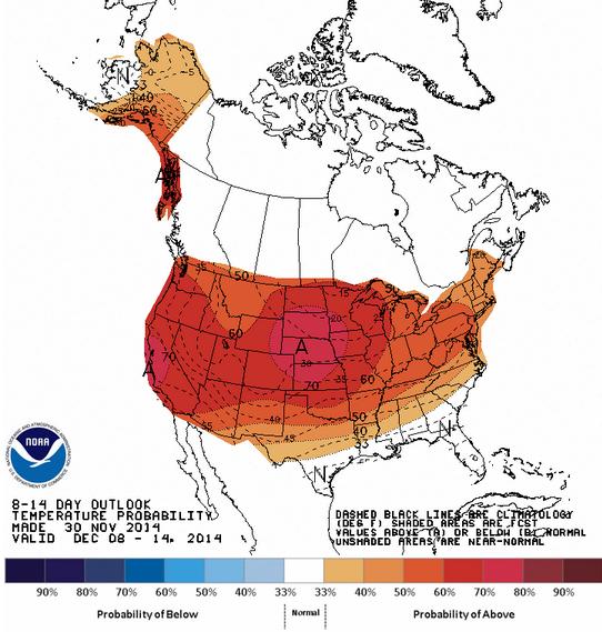
Temperature Outlook Ahead
According to NOAA's CPC, the 8 to 14 day temperature outlook through mid December suggests a warm bias. Temperatures certainly look to be warmer than what they were like in mid November!
Thanks again for checking in and have a great week ahead! Don't forget to follow me on Twitter @TNelsonWX

No comments:
Post a Comment