32 F. high in the Twin Cities Saturday.
30 F. average high on December 7.
5 F. high on December 7, 2013.
December 7, 1982: A farmer near St. Bonifacius bailed his 4th crop of alfalfa hay on this day.
December 7, 1927: A blizzard hits the arrowhead with heavy snows and 70 mph winds at Duluth.
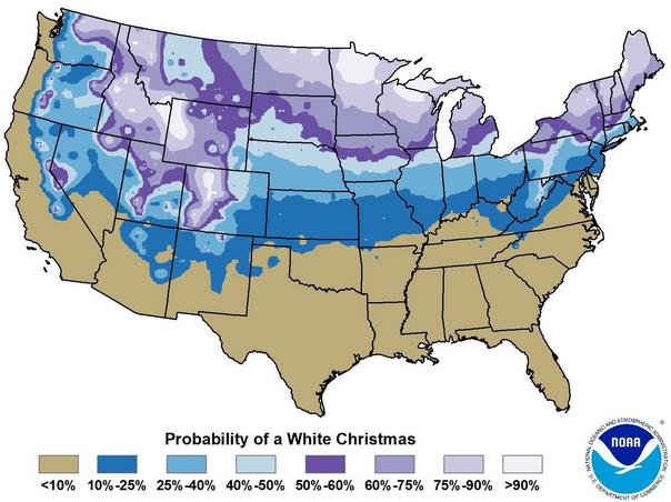
A Beige Christmas?
Dreaming
of a white Christmas? Bing Crosby had the right idea. There's nothing
like family, friends, gifts under the tree - and a fresh coating of
white to help celebrate a birthday like no other.
NOAA records
show that, since 1871, roughly 3 out of 4 December 25ths in the Twin
Cities have an inch or more of snow on the ground - the definition of
"white Christmas". Amazingly, this may not be one of those years.
Here's
why this year may be brown or bright beige: we only have 1 inch of snow
on the ground officially at MSP International. Another coating is
possible later today as a clipper passes to our north. The pattern
favors big storms on both coasts, but little "weather" close to home the
next 2 weeks. A fire-hose of Pacific moisture passes well south of
Minnesota - symptoms of a slowly developing El Nino.
Bitter air
remains bottled up in Canada until further notice. ECMWF guidance shows
40s by the end of the week; a chance of 50s by Saturday. After a numbing
November it's hard to believe most of the snow in our yards will be
gone a week from today.
Will this milder westerly flow, a Pacific reprieve, dominate our pattern the rest of the winter? Possible, but unlikely.
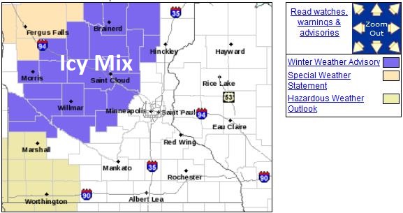 Winter Weather Advisory
.
A mix of freezing rain and sleet may ice up roads over much of central
and northern Minneosta during the morning and midday hours, changing
over to snow showers by afternoon. Details from the Twin Cities National
Weather Service:
...WINTRY MIX EXPECTED ACROSS WEST CENTRAL MINNESOTA SUNDAY
MORNING...

A WINTRY MIX OF FREEZING RAIN AND SLEET IS EXPECTED TO DEVELOP
OVER WEST CENTRAL MINNESOTA SUNDAY MORNING. IT WILL SPREAD EAST INTO
CENTRAL MINNESOTA BY MID MORNING. A WINTER WEATHER ADVISORY HAS
BEEN ISSUED FOR THE AREA LOCATED MAINLY NORTH OF AN OLIVIA...
HUTCHINSON AND MORA LINE FROM 6 AM UNTIL NOON SUNDAY. UNTREATED
ROADWAYS AND SIDEWALKS WILL BECOME SLICK. CAUTION IS ADVISED.
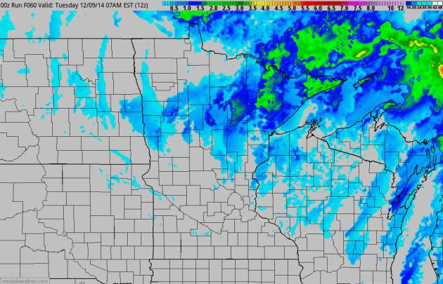 Nuisance Snowfall
.
I expect a coating of slush by tonight in the metro area, maybe an inch
or two of snow for parts of central and northern Minnesota as a weak
clipper tracks across the state. After this I don't see any accumulating
snow looking out at least 10 days. Source: NOAA NAM and HAMweather.com.
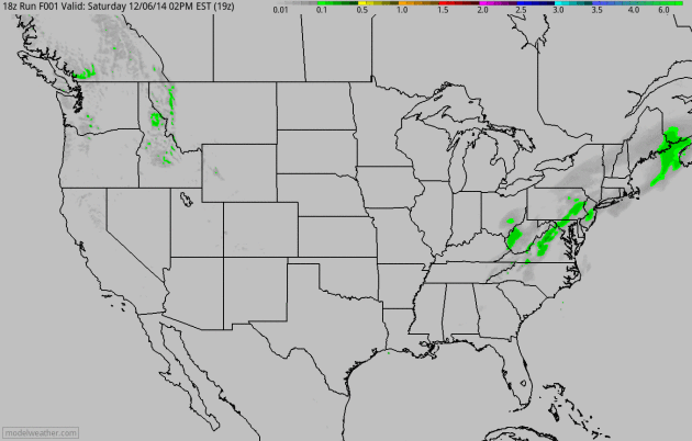 Another Pacific Smack - Nor'easter Brewing By Tuesday
.
60-hour NAM accumulated precipitation shows more heavy rain approaching
the Pacific Northwest late Sunday and Monday, an area of low pressure
intensifying along a stalled front along the eastern seaboard capable of
heavy rain and coastal flooding Tuesday into Wednesday from New Jersey
to Cape Cod with heavy snow over interior New England.
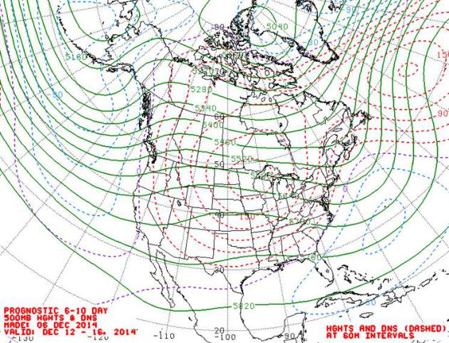 Steering Winds December 12-16.
500 mb winds are (very) zonal in mid-December, implying a few days in
the 40s, maybe 50F by Saturday. As long as steering winds aloft howl
from the west it will be difficult to pull in bitter air from the Arctic
or Siberia. How long this relatively mild pattern lingers is a
different question - I suspect it will hold on thru much of December;
after that all bets are off.
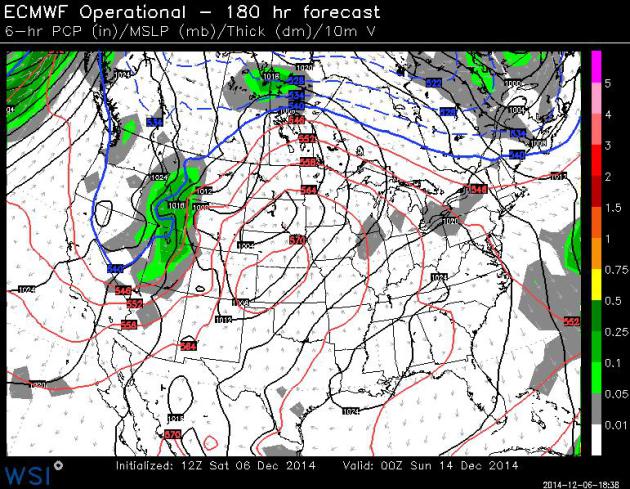 Instant March
.
The ECMWF model is consistently pulling unseasonably mild air northward
into Minnesota; even with a little leftover snow, clouds and fog
temperatures should surge into the 40s, possibly reaching the 50s by
Saturday, some 20-25F warmer than average. Map valid Saturday evening
courtesy of WSI.
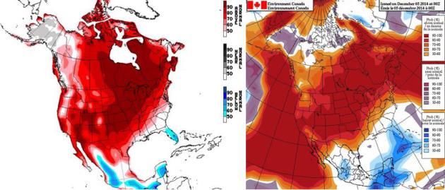
NAEFS Extended Temperature Trends.
Both NOAA CPC (upper left) and Environment Canada (upper right) predict
temperatures well above average between December 13 and December 20.
The atmosphere will be warm enough for rain from the 10th to the 18th.
Coupled with highs in the 30s and 40s (with a high topping 50F one week
from today) there may be precious little left of the 2" of snow on the
ground at MSP International. If we do see a white Christmas it'll be by
the skin of our teeth, a couple days before the 25th.
A Forgettable November. Yes, it was cold. Dr. Mark Seeley includes a few nuggets about November in this week's installment of
WeatherTalk: "
On
a statewide basis November of 2014 was the coldest since 1995 with over
two-thirds of the days showing temperature values that were colder than
normal. Since 1895 it ranked as 9th coldest November statewide. For the
Twin Cities the 11 consecutive days with below freezing temperatures
(Nov 10-20), tied as the third longest November stretch below freezing
in history back to 1871..."
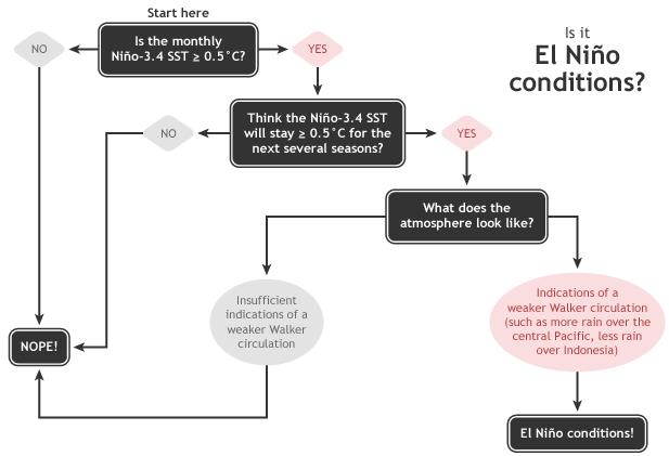
December's ENSO Update: Close, But No Cigar. We are close to an official El Nino, but according to
NOAA's climate.gov, not quite there just yet. Here's an excerpt: "...
Recently, the observed increase in SST anomalies has generally matched up well with forecasts from most climate models. The August, September, and October forecasts from the NMME predicted
a November Niño3.4 SST anomaly between +0.7°C and +0.9°C. Due to the
recent warming and our expectation that ocean temperatures will continue
to be above-average, forecasters this month have again increased the odds of El Niño this winter to an approximately 2-in-3 chance."
Graphic credit:
"Summary of decision process in determining El Niño conditions." Figure by Glen Becker and Fiona Martin.
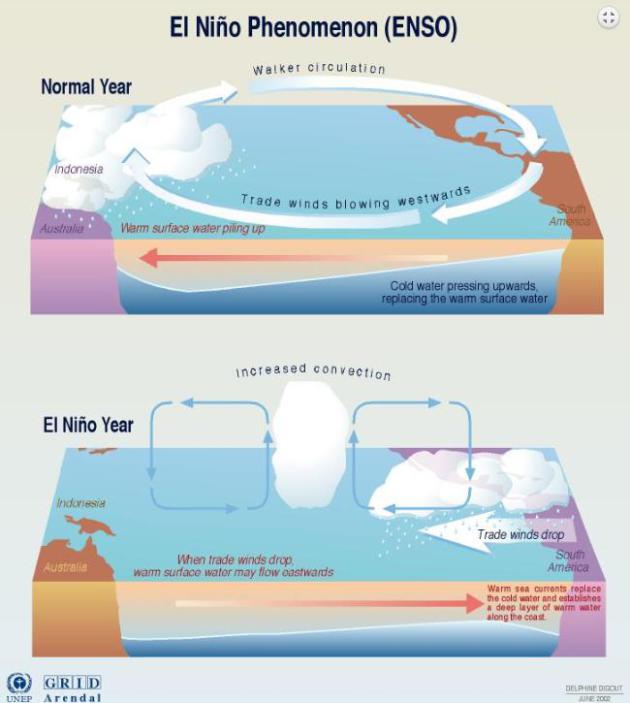
Fishing In Pink Waters.
Here is one of the better explanations I've seen on El Nino and ENSO in
general, and how this periodic warming of Pacific ocean water can
impact global weather, courtesy of
Road to Paris: "...
Here’s
the basic idea of El Niño. Every few years, a relatively warm patch of
water—the pink on Pierce’s map—forms beneath the Pacific. The difference
is just a few degrees, but in a global context, the extra heat can
transform the seasonal climate. Some years, the warm region spreads
outward and eventually upward, where it meets with easterly trade winds.
This creates a feedback loop. Warm water undermines easterly winds that
normally enable an upwelling of cool water, which amplifies warming and
in turn further slows the winds. It’s this moment of
atmospheric-oceanic coupling that helps scientists define the start of
El Niño. Wind and water exist in delicate balance with the rest of the
climate—so El Niño sets off a cascade of effects..." (Graphic credit: NOAA CPC, NCEP).
 TODAY
TODAY: Cloudy. Slushy PM mix. Up to 1 inch. Winds: South 15. High: 34
SUNDAY NIGHT: A little wet snow - slippery patches. Low: 31
MONDAY: Flurries taper, slow clearing. High: 32
TUESDAY: Sunny and cooler, light winds. Wake-up: 13. High: 27
WEDNESDAY: Plenty of sun, turning milder. Wake-up: 17. High: 31
THURSDAY: Partly sunny, removing extra layers. Wake-up: 28. High: 39
FRIDAY: Some sun, hints of March in the air. Wake-up: 33. High: 46
SATURDAY: Patchy clouds and fog. Mild breeze. Wake-up: 35. High: 52
Climate Stories...
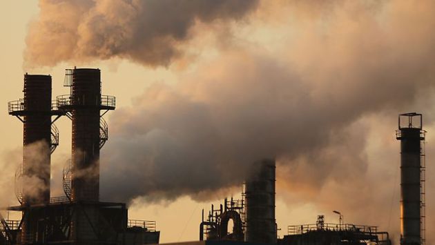 Cutting Carbon Pollution Is The Key To Curbing Global Warming.
 Here's an excerpt of an article from John Abraham at St. Thomas, writing for
The Guardian: "...
Most
of us already know this, but not all greenhouse gases are created
equal. There are some greenhouse gases that, when emitted, only stay in
the atmosphere for a short time. There are other greenhouse gases (like
carbon dioxide) that stay aloft for decades to centuries. Finally, there
are some that stay airborne for an intermediate duration. It has often
been stated that we can “buy time” by focusing on short-lived greenhouse
gases. Reducing things like black carbon or methane can give us some
extra years to get our act together on carbon dioxide. But this
suggestion is challenged in the PNAS paper..."
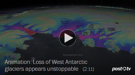
West Antarctic Melt Rate Has Tripled. Here's a clip from a press release by AGU,
The American Geophysical Union:
"A comprehensive, 21-year analysis of the fastest-melting region of
Antarctica has found that the melt rate of glaciers there has tripled
during the last decade. The glaciers in the Amundsen Sea Embayment in
West Antarctica are hemorrhaging ice faster than any other part of
Antarctica and are the most significant Antarctic contributors to sea
level rise. This study by scientists at the University of California,
Irvine (UCI), and NASA is the first to evaluate and reconcile
observations from four different measurement techniques to produce an
authoritative estimate of the amount and the rate of loss over the last
two decades. “The mass loss of these glaciers is increasing at an
amazing rate,” said scientist Isabella Velicogna, jointly of UCI and
NASA’s Jet Propulsion Laboratory, Pasadena, California..."
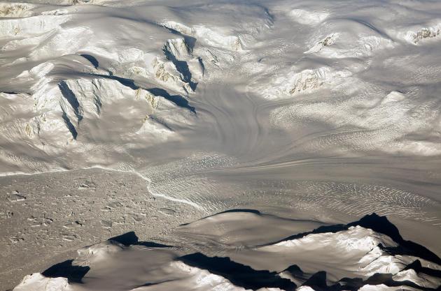
Photo credit above: "
Glaciers
seen during NASA’s Operation IceBridge research flight to West
Antarctica on Oct. 29, 2014. A new analysis of the fastest-melting
region of Antarctica has found that the melt rate of glaciers there has
tripled during the last decade." Credit: NASA/Michael Studinger.
Research Casts Alarming Light on Decline of West Antarctic Glaciers. The Washington Post has the video and article; here's the introduction: "
For
two decades, scientists have kept a close watch on a vast, icebound
corner of West Antarctica that is undergoing a historic thaw. Climate
experts have predicted that, centuries from now, the region’s mile-thick
ice sheet could collapse and raise sea levels as much as 11 feet. Now,
new evidence is causing concern that the collapse could happen faster
than anyone thought. New scientific studies this week have shed light on
the speed and the mechanics of West Antarctic melting, documenting an
acceleration that, if it continues, could have major effects on coastal
cities worldwide..."
Antarctic Ice Sheets Threatened By Warm Water Rising From Below. Here's a slightly different perspective on the new research findings, an excerpt courtesy of
Bloomberg: "
A
layer of warmer water under Antarctica’s ice sheet has been increasing
for at least three decades, possibly due to changed wind patterns linked
to climate change, and may make it melt faster. That would prompt the
oceans to rise faster than expected, according to an article today in
the journal Science. “We likely are underestimating the sea-level rise
that comes from Antarctica,” said Sunke Schmidtko, one of the paper’s authors and a researcher at GEOMAR Helmholtz Centre for Ocean Research Kiel..."
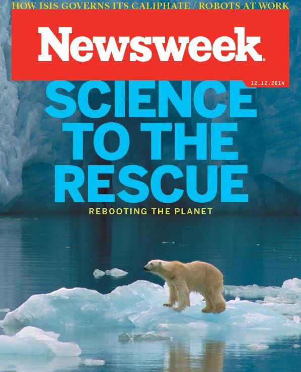
Planet Reboot: Fighting Climate Change With Geoengineering.
Having engineers fix our overheated planet by spraying chemicals into
the stratosphere? What can possibly go wrong. Here's a clip from
Newsweek's cover story: "...
In
the meantime, the world’s climate scientists have begun to turn their
attention to generating workable geoengineering projects that can either
bypass governmental red tape or reverse the change so quickly and with
such great efficacy that it might not matter if the world never manages
to get its act together. Today there are a slew of ideas for
geoengineering the planet. They range from the very simple to the very
sci-fi. But they’re all based in science, and they could one day be the
last chance to save the human race..."
Deniers Are Not Skeptics. Here's a clip from a post by CSI,
The Committee For Skeptical Inquiry: "...
Real
skepticism is summed up by a quote popularized by Carl Sagan,
“Extraordinary claims require extraordinary evidence.” Inhofe’s belief
that global warming is “the greatest hoax ever perpetrated on the
American people” is an extraordinary claim indeed. He has never been
able to provide evidence for this vast alleged conspiracy. That alone
should disqualify him from using the title “skeptic.” As scientific
skeptics, we are well aware of political efforts to undermine climate
science by those who deny reality but do not engage in scientific
research or consider evidence that their deeply held opinions are wrong..."


No comments:
Post a Comment