35 F. high in the Twin Cities Sunday.
30 F. average high on December 7.
1 F. high on December 7, 2013.
1/10th of an inch of snow fell yesterday at MSP International Airport.
1" of snow on the ground.
December 7 in Minnesota Weather History. Source: Twin Cities National Weather Service:
1995:
A strong low pressure system passed across Northern Minnesota which
produced considerable snowfall in advance of an intense cold front.
Snowfall of five to eight inches was common with eight inches recorded
at New London and Alexandria. The most snow reported was 9.6 inches in
Mound. The Minneapolis, St. Paul International Airport received 7.1
inches.The cold front moved through by late morning on the 8th as
temperatures dropped 20 degrees within an hour of the frontal passage.
Strong northwest winds of 20 to 40 mph immediately behind the front
resulted in severe blowing and drifting and white-out conditions in many
areas. Over 150 schools closed early or cancelled classes. Many
businesses closed early as well. The Governor ordered state offices
closed at noon on the 8th, sending thousands of state employees home.
Over 100 outbound flights were cancelled at the Twin Cities
International Airport, but the airport remained open.
1876: The term "Blizzard" first used in the government publication “Monthly Weather Review.”
1804:
John Sayer at the Snake River Fir Trading Post near present day Pine
City mentions: "Cold day. Thermometer 10 degrees below freezing." Lewis
and Clark also noted this cold wave at their winter quarters in Ft.
Mandan, North Dakota near present day Bismarck.
Dear Santa
Dear
Santa, please send Minnesota a polar-vortex-free winter. A shiny new El
Nino would be nice, with mild winds howling from the Pacific some of
the time. A Doppler on the roof would be great too.
No, I haven't been a good boy. Yes, I will get off your lap now.
And
was I the only one who did a double-take during Sunday's Vikings game?
At one point the TV announcer referenced "frigid" weather at TCF
Stadium. I frowned and checked the air temperature. 33F with a wind
chill of 24F. Frigid? Maybe in Manhattan, but 30s in December, while
properly dressed? Pretty reasonable.
Because there's no such thing as bad weather, just inappropriate clothing choices.
You'll
be able to shed a few layers by late week as a mild high pressure ridge
direct from the Pacific arrives. An extended thaw is likely; 40s by
late week with a good chance of 50F Saturday. Mild air passing over cold
ground may spark clouds & dense fog later in the week, but the
pattern looks benign and storm-free looking out 10 days.
16 inches
of snow fell last December; a year ago highs were already stuck in the
teens with subzero lows. December 2014 should be easier to take: milder
with less snow.
Consider it an early gift.
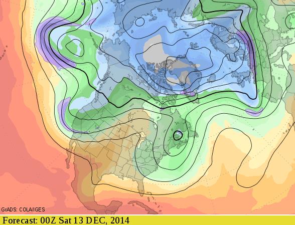
Friday Evening Jet Stream.
A sprawling ridge of high pressure pushes 40s and even some 50s into
the Upper Midwest by late week; Saturday probably the mildest day in
sight for Minnesota. An omega-block pattern favors major storms over New
England and the Pacific Northwest this week. Credit: GrADS:COLA/IGES.
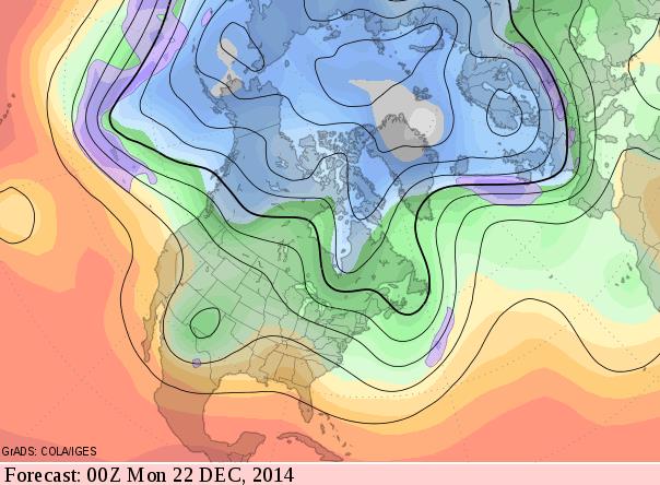
Predicted Jet Stream Configuration: Sunday Evening, December 21.
GFS data shows a modified zonal flow roughly 2 weeks out, a more active
southern branch of the jet stream, but Pacific air engulfing most of
the USA as the coldest air remains over northern Canada and Alaska.
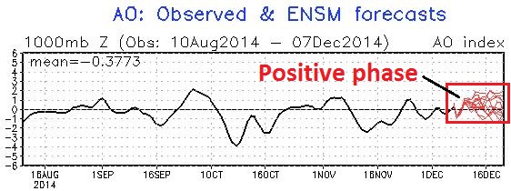
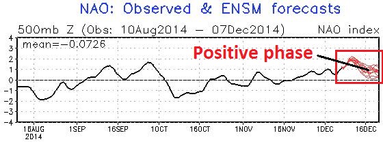
Positive Phase of AO and NAO.
A strong negative phase corresponds with a higher-amplitude jet stream,
capable of sweeping arctic air southward into the USA. A strong
positive phase means stronger, west to east winds aloft, which tends to
trap bitter air at far northern latitudes, with fewer intrusions into
the Lower 48. A positive phase into mid-December will ensure
temperatures above average. How long will the (milder) positive phase
linger - too early to know.
Extended Thaw.
The warming trend we've been advertising for nearly 2 weeks is still on
track. It's going to warm up - the question is how mild. The answer to
that question will depend on how quickly snow melts, and whether mild,
Pacific air passing over cold ground sparks thick fog and low stratus
clouds Saturday, which would keep us a few degrees cooler. 40s are
possible as early as Thursday, with a shot at 50F by Saturday.
Alerts Broadcaster Briefing: Issued Sunday afternoon, December 7, 2014.
*
No travel problems expected Monday, but heavy, windswept rain from a
strengthening Nor'easter pushes up the Mid Atlantic coast Tuesday,
soaking Washington D.C., Philadelphia and New York City, where flash
flooding is expected - heavy rains push into coastal New England,
including Boston, Tuesday night into Wednesday.
* Coastal flooding possible Delaware and New Jersey to Cape Cod.
*
Significant snow piles up over interior New England, upstate New York
and parts of central PA as storm stalls over northeast Wednesday and
Thursday.
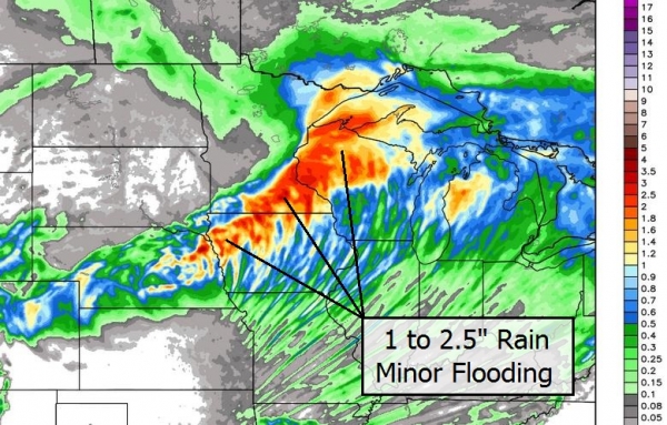
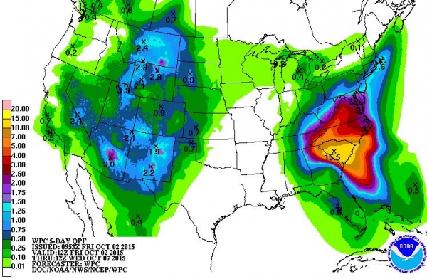
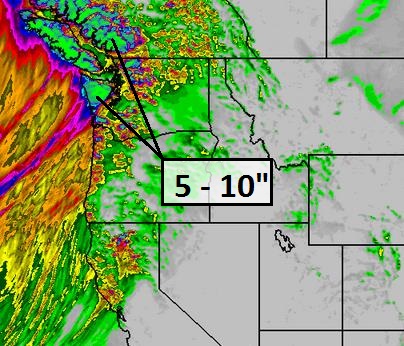
* Series of Pacific storms forecast to drop 5-10" rains
over Pacific Northwest. Serious river flooding possible Olympics and
northern Cascades, moderate flooding possible Seattle/Tacoma to
Vancouver this week.
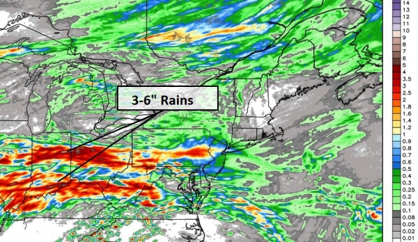
Tuesday Soaker.
Internal Alerts Broadcaster models print out some 2-3"+ rainfall
amounts near Washington D.C., Baltimore and Rehoboth, Delaware, with
1-2" amounts Philadelphia and New York City to Boston by Wednesday. With
significant frost in the ground much of that rain water will run off
into streets and streams. Some urban flooding is likely, with the
greatest travel delays Tuesday into Wednesday.
Flash Flood Guidance.
Our models show that 1.5" of rain falling over a 6 hour period would be
enough to spark flash flooding in Washington D.C., where 3.13" of rain
is predicted over the next 60 hours. Some 2-3"+ amounts are possible
from D.C. and Baltimore to Allentown and the suburbs of New York City
Tuesday and Tuesday night.
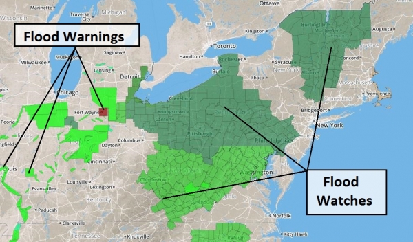
Latest Advisories.
NOAA may have to issue Flash Flood Watches for portions of the Mid
Atlantic region and New England by tomorrow. For now Winter Storm
Watches are posted from the Poconos and far northwest New Jersey
northward to the Catskills, for plowable snowfall amounts by midweek. It
would appear that major eastern cities will avoid a heavy snow event
with this coastal system. Strong winds will spark coastal flooding,
especially at high tide. Details from the NWS:
THE NATIONAL WEATHER SERVICE IN MOUNT HOLLY HAS ISSUED A COASTAL
FLOOD WATCH...WHICH IS IN EFFECT FROM MONDAY MORNING THROUGH
MONDAY AFTERNOON.
* LOCATION...COASTAL SECTIONS OF NEW CASTLE AND SALEM COUNTIES ALONG
THE UPPER DELAWARE BAY.
* COASTAL FLOODING...THE POTENTIAL FOR WIDESPREAD MINOR TO
MODERATE TIDAL FLOODING.
* TIMING...AROUND HIGH TIDE MONDAY, WHICH OCCURS BETWEEN 1045 AM
AND 130 PM.
* OUTLOOK...TUESDAY MORNING`S HIGH TIDE CYCLE WILL SEE AT LEAST
MINOR COASTAL FLOODING AND THERE IS SOME POTENTIAL FOR MODERATE
FLOODING. A WATCH HAS NOT BEEN ISSUED AT THIS TIME SINCE THERE
IS SOME DOUBT AS TO THE TIMING OF THE STRONGEST WIND TO AFFECT
THIS AREA.
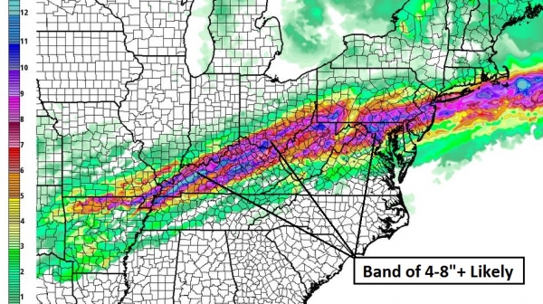
Heavy Snow Potential.
This band may shift over time, but right now models show the best
chance of a plowable snowfall from near Altoona and Williamsport, PA to
Rochester and Syracuse, New York. I suspect heavy snow amounts may push
into the Hudson River Valley and the Berkshires of Massachusetts by
Wednesday and Thursday.
Stormy Book Ends.
Conditions are ripe for street and (minor) river flooding across New
England later this week, the result of 1-3" rains. More serious flooding
is expected over the Pacific Northwest as a series of very wet storms
blow in off the Pacific. Models hint at 14" rainfall amounts for the
Olympic Range of Washington State, capable of mudslides and serious
river flooding. Seattle, Portland and northern California may see
moderate urban flooding later this week.
Why We're Concerned.
Our internal models show extreme amounts of rain (and very heavy
mountain snows) over the Pacific Northwest. I could see avalanche
conditions above 6,000 feet with flash flooding and river flooding at
lower elevations by Thursday.
Summary: With El
Nino gradually ramping up conditions will become increasingly ripe for
major storms slamming into the West Coast, and a series of coastal
storms tracking up the East Coast. One such storm will spark heavy rain
and flash flooding along the I-95 corridor Tuesday into Wednesday, with
high winds creating beach erosion and coastal flooding from Delaware and
New Jersey Tuesday to Cape Cod by Wednesday. Heavy snows are possible
from interior Pennsylvania and upstate New York into interior New
England by midweek.
Meanwhile the Pacific Northwest is bracing for
a parade of sloppy Pacific storms, with the best chance of urban and
river flooding Wednesday and Thursday. Relatively quiet weather is
expected over the central USA the next 7-10 days. We'll keep you posted.
Paul Douglas - Senior Meteorologist - Alerts Broadcaster
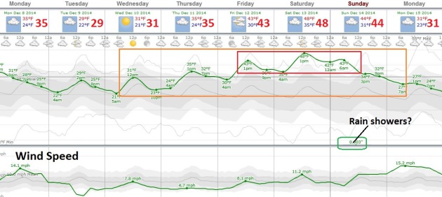
TODAY: Flurries taper, clouds linger. Winds: NW 10-20. High: 33
MONDAY NIGHT: Gradual clearing. Low: 20
TUESDAY: Bright sun, less wind. High: 29
WEDNESDAY: Partly sunny and milder. Wake-up: 18. High: 32
THURSDAY: Peeks of sun, breathing easier. Wake-up: 22. High: 38
FRIDAY: Intervals of sun, jacket weather. Wake-up: 30. High: 44
SATURDAY: March preview. Patchy clouds, fog. Wake-up: 37. High: near 50
SUNDAY: Mild start, passing rain shower. Wake-up: 45. High: 48
Climate Stories...
Cutting Carbon Pollution Is The Key To Curbing Global Warming. Here's an excerpt of an article from John Abraham at St. Thomas, writing for
The Guardian: "...
Most
of us already know this, but not all greenhouse gases are created
equal. There are some greenhouse gases that, when emitted, only stay in
the atmosphere for a short time. There are other greenhouse gases (like
carbon dioxide) that stay aloft for decades to centuries. Finally, there
are some that stay airborne for an intermediate duration. It has often
been stated that we can “buy time” by focusing on short-lived greenhouse
gases. Reducing things like black carbon or methane can give us some
extra years to get our act together on carbon dioxide. But this
suggestion is challenged in the PNAS paper..."
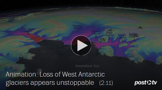
West Antarctic Melt Rate Has Tripled. Here's a clip from a press release by AGU,
The American Geophysical Union:
"A comprehensive, 21-year analysis of the fastest-melting region of
Antarctica has found that the melt rate of glaciers there has tripled
during the last decade. The glaciers in the Amundsen Sea Embayment in
West Antarctica are hemorrhaging ice faster than any other part of
Antarctica and are the most significant Antarctic contributors to sea
level rise. This study by scientists at the University of California,
Irvine (UCI), and NASA is the first to evaluate and reconcile
observations from four different measurement techniques to produce an
authoritative estimate of the amount and the rate of loss over the last
two decades. “The mass loss of these glaciers is increasing at an
amazing rate,” said scientist Isabella Velicogna, jointly of UCI and
NASA’s Jet Propulsion Laboratory, Pasadena, California..."
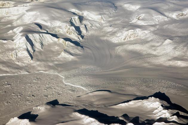
Photo credit above: "
Glaciers
seen during NASA’s Operation IceBridge research flight to West
Antarctica on Oct. 29, 2014. A new analysis of the fastest-melting
region of Antarctica has found that the melt rate of glaciers there has
tripled during the last decade." Credit: NASA/Michael Studinger.
Research Casts Alarming Light on Decline of West Antarctic Glaciers. The Washington Post has the video and article; here's the introduction: "
For
two decades, scientists have kept a close watch on a vast, icebound
corner of West Antarctica that is undergoing a historic thaw. Climate
experts have predicted that, centuries from now, the region’s mile-thick
ice sheet could collapse and raise sea levels as much as 11 feet. Now,
new evidence is causing concern that the collapse could happen faster
than anyone thought. New scientific studies this week have shed light on
the speed and the mechanics of West Antarctic melting, documenting an
acceleration that, if it continues, could have major effects on coastal
cities worldwide..."


No comments:
Post a Comment