
Dwindling Snow Pack
By Todd Nelson
"Todd, where's all the snow?" I'm getting relentless texts from friends who want to know when the next big snow storm is on the way. They're hoping to fire up the snowmobiles and head out on the trails.
It's no surprise the winter sales/trips are dependent on the weather. When snow amounts are down, sales tend to be down. November started off with a bang! Minneapolis managed to tie the 9th coldest November on record and had nearly 9.5" of snow (near average). St. Cloud saw nearly 17.5" of snow (9.2" above average). However, the recent mild weather has taken its toll on that promising snow pack; we are down to only 1" snow depth at Minneapolis and 2" at St. Cloud.
Unfortunately, for those hoping to freshen up the snow pack, this week isn't the one. Extended model runs show a VERY mild trend through mid December. I think you're going to start seeing a few more brown spots in your lawn this week as temperatures jump up into the 40s/50s across the southern part of the state by the end of the week!
As much as I am enjoying quieter commutes with the lack of snow, not sure I'd trade it in for a brown Christmas. The last one, officially, was actually in 2011. -Todd Nelson
============
MONDAY NIGHT: Gradual clearing. Low: 18
TUESDAY: Bright sun, less wind. High: 28. Winds: Turning ESE 5-10
TUESDAY NIGHT: Mostly clear. Low: 17
WEDNESDAY: Partly sunny and milder. More clouds/drizzle overnight? High: 31
THURSDAY: Peeks of sun, mid December thaw. Wake-up: 20. High: 34
FRIDAY: A shot at 40! Clouds thicken late. Wake-up: 25. High: 40
SATURDAY: Mild and cloudy. Sprinkles/drizzle possible. Wake-up: 35. High: 46
SUNDAY: Light wintry mix, turning colder later. Wake-up: 40. High: 41
MONDAY: Breezy and colder. A few flurries. Wake-up: 25. High: 29.
==============
This Day in Weather History
December 9th
2003: Significant snow with amounts between 6 to 10 inches fell from southwest Minnesota, across the Minneapolis-St. Paul area, into west central Wisconsin. Winds across the area were 25 to 30 mph, with blowing and drifting snow in open areas. Although some parts of far south central Minnesota only picked up 4 to 6 inches, winds in this area were a little stronger, creating near-blizzard conditions. The greatest snowfall totals occurred in the Twin Cities metro, where Chaska, Chanhassen and New Hope all picked up 11 inches. Ten inches were recorded at Lamberton, Springfield and Gaylord. There was a sharp cutoff on the northern edge of the snow; Lamberton in southernmost Redwood County tallied 10 inches, while 25 miles to the north at Belview in far northern Redwood County, only 2 inches was recorded. Rockford, straddling the Hennepin/Wright County line, received 6 inches, whereas Buffalo, 10 miles to the northwest in central Wright County, only received 1 inch.
1995: The passage of the strong low pressure system on the 8th led to wind chill readings of 50 to 75 below as strong northwest winds of 25 to 40 mph ushered significantly colder air across the region. The dangerously cold wind chill readings persisted through the morning of the 9th.
1961: Snowstorm hits central Minnesota. Mora gets about a foot.
===============
Average High/Low for Minneapolis
December 9th
Average High: 29F (Record: 58F set in 1939)
Average Low: 14F (Record: -27F set in 1876)
===============
Sunrise/Sunset Times for Minneapolis
December 9th
Sunrise: 7:39am
Sunset: 4:32pm
================
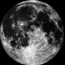
Moon Phase for December 9th at Midnight
2.8 Days After Full Moon
====================
Minneapolis Temperature Trend
I thought for sure we were in for another extremely cold and snowy winter with November starting off as cold and snowy as it did! Get this, the average temperature for November was 25.4F and tied for the 9th COLDEST November on record! We also saw 9.4" of snow, which was -0.9" below average. So far this month (thru December 7th) temperatures were running -4.4F below average thanks to an extremely cold start to the month. We are also running nearly 3" below average snowfall for the month so far. Looking at the temperature outlook ahead, we warm up rather nicely this week with highs in the 40s Friday-Sunday before temperatures return to near normal early next week. With temperatures as warm as they are, it appears that our December snowfall deficit will continue to mount. To be honest, I kind of enjoy cold and snowy weather leading up to the holiday seaon, but after the 1st of the year... bring on the 40s!!
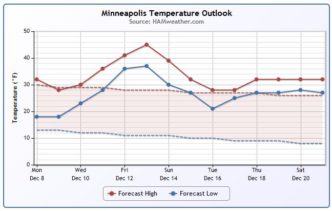
Minneapolis Temperature Outlook
Thanks to a more active weather pattern on the West Coast, our weather closer to home will be quite mild and quiet as a large ridge of high pressure builds in the middle part of the country. The National Weather Service has a little more on the temperature outlook through the week ahead.
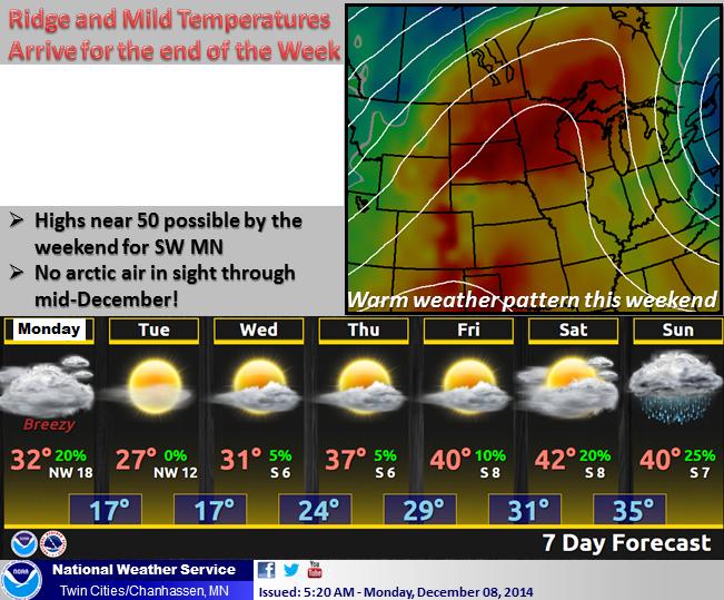
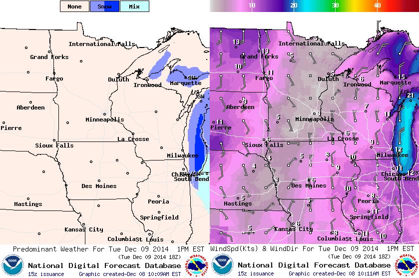
Tuesday Weather Outlook
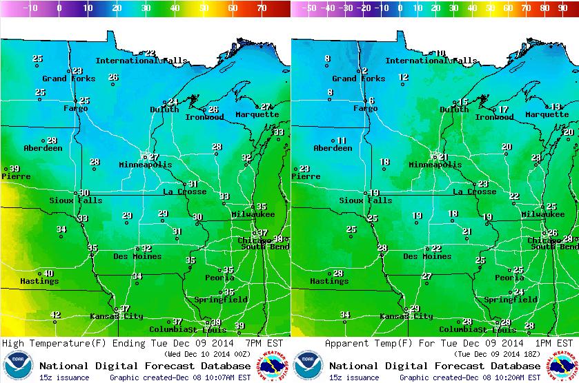
Temperatures on Tuesday will still be a bit on the chilly side with feels like temps (image on right) in the 10s and 20s around midday. It'll actually still feel like the single digits in northwestern Minnesota!
Tuesday Weather Outlook
Weather conditions on Tuesday will be much improved from Monday with more sunshine and lighter winds as a bubble of high pressure slides in. High pressure will stick around for much of the week with sunshine continuing through Friday... Good news for anybody traveling around the Midwest this week!
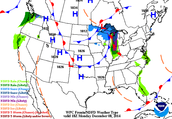
National Weather Outlook
A storm system will develop along the East Coast early this week with heavy snow potential for inland locations. It appears that snow tallies will be much less near the coast as temperatures will be warm enough for mostly rain there. Moisture will also steadily fall in the Pacific Northwest through midweek. The good news is that parts of northern California will still be under the influence of this Pacific flow and will still be able to benefit from this much needed moisture! Meanwhile, the middle part of the country will be very quiet through midweek.
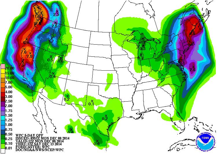
5 Day Precipitation Outlook
According to NOAA's HPC, the 5 day precipitation outlook shows considerable moisture across the West Coast and the Northeast this week! Note that there could be a few spots along the West Coast, especially in the higher elevations that get nearly 8" to 10" or more! Unfortunately, flooding will continue to be a big concern with all this moisture moving in!
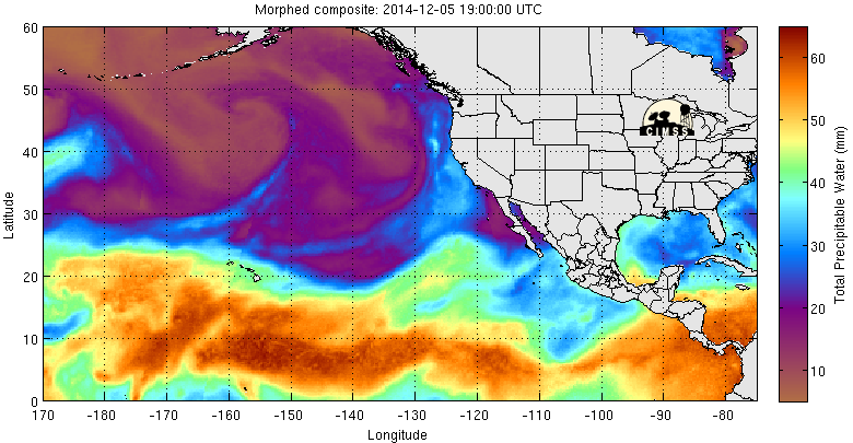
Why So Much Western Moisture?
Take a look at the precipitable water loop below and note the more vibrant blues being whisked northeast from near the tropical locations to the West Coast. Large storm systems in the eastern Pacific Ocean are doing an efficient job at tugging this moisture northward in depositing it along the West Coast. Sure it's nice to see this moisture there, but it sure is an aweful lot of moisture in a very short amount of time! Flood concerns will remain high as this heavy moisture moves in through the week.
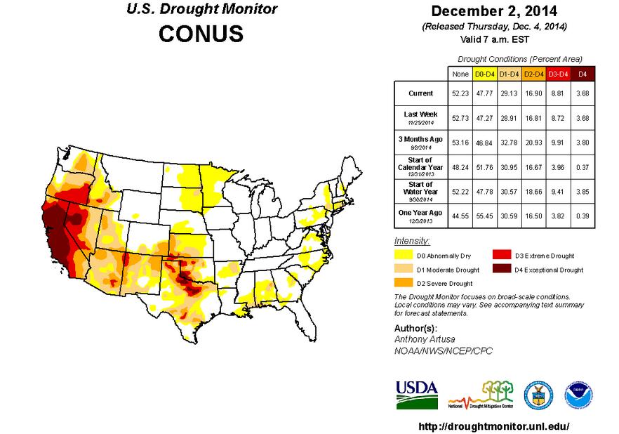
U.S. Drought Monitor
According to the U.S. Drought Monitor, nearly 50% of the nation is considered to be abnormally dry with nearly 17% in a SEVERE DROUGHT.
"The first half of the past week was dominated by an upper-air ridge over the far western contiguous United States (CONUS), and a deep trough over the east-central CONUS. A major storm developed along the Southeast Coast and tracked northeastward just prior to Thanksgiving. This nor’easter brought moderate rain (0.5-2.0 inches) to the Southeast, a mix of rain, sleet, and snow (though mostly rain) along the middle and northern Atlantic coastal plain, and significant amounts of snow across the interior Northeast (up to a foot of snow was reported in the higher terrain of northwest New Jersey and eastern Pennsylvania). By Friday and Saturday, energy diving southward out of British Columbia into the Pacific Northwest and then eastward across the northern Rockies brought heavy mountain snow to these areas. Some precipitation made it as far south as north-central California, but these amounts were generally under an inch (liquid equivalent). Late in the period, light precipitation (0.5-inch or less) fell over central portions of California, and along the far southern coast, though amounts were nowhere near sufficient to offset longer-term precipitation deficits."
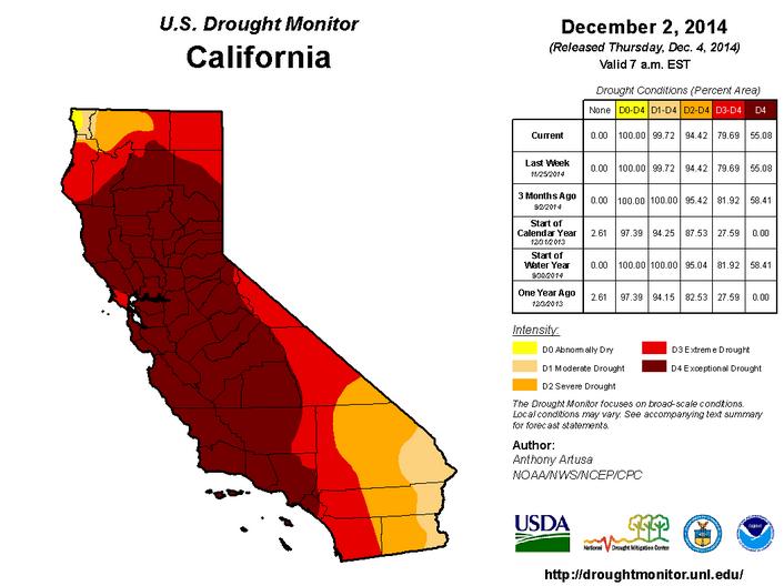
California Drought Continues
Despite the recent moisture last week, the U.S. Drought Monitor still suggests that nearly 95% of the state is considered to be in a SEVERE DROUGHT with nearly 55% in an EXCEPTIONAL DROUGHT. The upcoming moisture is certainly much needed, but because it has been so dry, flash flood concerns will be extremely high!
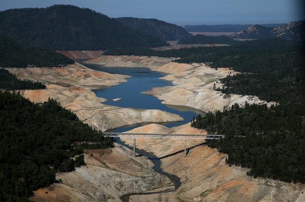
"Study: California Drought is the Most Severe in at Least 1,200 Years"
Here's an interesting read from WashingtonPost.com about how severe the drought has been in California!
"The current drought in California is the worst the state has seen in at least 1,200 years, according to a recent study published by the American Geophysical Union. Scientists at Woods Hole Oceanographic Institute and the University of Minnesota reconstructed California’s temperature and precipitation history back to 800 A.D. using tree ring data. Hidden in this millennium of data they found as many as 66 dry periods of at least three to nine years. In the entire 1,200 year period they studied, there were only three droughts that were similar in nature to the current drought."
Read more from WashingtonPost.com HERE:
(A section of Lake Oroville is nearly dry on Aug. 19, in Oroville, California. As the severe drought in California continues for a third year, water levels in the state’s lakes and reservoirs is reaching historic lows. (Justin Sullivan/Getty Images)
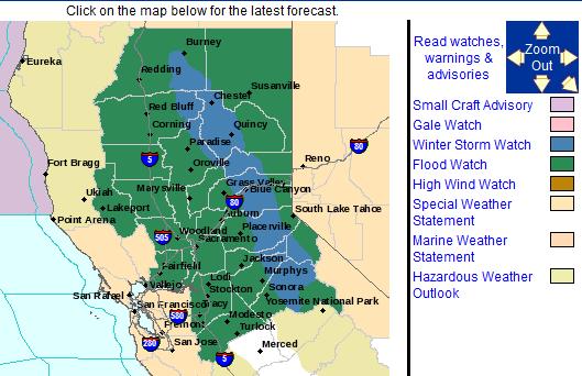
Western Snow and Flood Threat
The National Weather Service has issued a Winter Storm Watch from Wednesday - Friday above 5500ft. There could be as much as 2ft. - 3ft. of snow by the end of the week there!
* TIMING: SNOW WILL BEGIN LATE WEDNESDAY NIGHT AND CONTINUE INTO FRIDAY. THE PERIOD OF HEAVIEST SNOW IS EXPECTED THURSDAY AFTERNOON AND THURSDAY NIGHT. THE STRONGEST WINDS ARE EXPECTED WEDNESDAY NIGHT AND THURSDAY.
* LOCATIONS INCLUDE: LASSEN NATIONAL PARK...DONNER PASS...ECHO SUMMIT...CARSON PASS.
* SNOW ACCUMULATIONS: 10 TO 20 INCHES ABOVE 6000 FEET WITH 2 TO 3 FEET OR MORE POSSIBLE ALONG THE CREST.
* WIND: SOUTHERLY WINDS WILL INCREASE WEDNESDAY NIGHT WITH GUSTS TO 50 MPH OR MORE POSSIBLE BY DAYBREAK THURSDAY. SOUTHERLY WIND GUSTS OF 60 MPH OR MORE WILL BE POSSIBLE DURING THE DAY THURSDAY BEFORE WINDS DECREASE THURSDAY NIGHT.
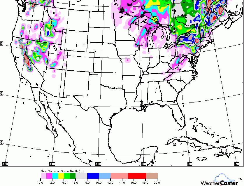
National Snow Potential
The national snow forecast suggests heavy snow across parts of the Sierra Nevada Range and for parts of the Northeast.
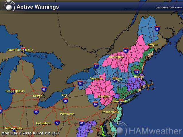
Northeast Snow/Flood Threat
Parts of the Northeast will be gearing up for another big snow event early this week. Winter Weather Headlines have been issued for some areas through Wednesday. There is also a big flood concern due to heavy rainfall and melting snow.
Winter Weather Headlines...
* ACCUMULATIONS...7 OR MORE INCHES POSSIBLE. SOME ICE ACCRETION MAY OCCUR AS WELL.
* MAXIMUM SNOWFALL RATES...POTENTIAL FOR 1 TO 2 INCHES PER HOUR.
* TIMING...SNOW IS EXPECTED TO DEVELOP AROUND SUNRISE TUESDAY SOUTH OF THE CAPITAL DISTRICT SPREADING NORTHWARD DURING THE MORNING. RAIN AND SLEET ARE THEN EXPECTED TO MIX IN WITH THE SNOW WITH A CHANGEOVER TO RAIN EXPECTED AT THIS TIME TUESDAY AFTERNOON FROM THE CAPITAL DISTRICT SOUTHWARD. STEADY PRECIPITATION WILL TAPER OFF LATE ON TUESDAY NIGHT. SUBTLE CHANGES IN THE TEMPERATURES WILL HAVE A LARGE IMPACT WHERE AND WHEN THE SNOW AND RAIN OCCURS AND FOR HOW LONG.
* IMPACTS...HAZARDOUS TRAVEL DUE TO SNOW COVERED ROADS AND POOR VISIBILITIES...AS WELL THE POTENTIAL FOR SOME POWER OUTAGES...ESPECIALLY WHERE HEAVY WET SNOW ACCUMULATES ON TREE BRANCHES.
* WINDS...NORTH INCREASING TO 10 TO 20 MPH WITH GUSTS UP TO 35 MPH.
Flooding Headlines...
* A DEVELOPING COASTAL STORM WILL SPREAD A WINTRY MIXTURE OF PRECIPITATION ACROSS EASTERN ULSTER AND DUTCHESS COUNTIES EARLY TUESDAY MORNING. AS WARMER AIR CONTINUES TO MOVE IN...THIS WILL CHANGE THE PRECIPITATION TO MOSTLY RAIN TUESDAY AFTERNOON INTO TUESDAY NIGHT. RAINFALL AMOUNTS 1 TO POSSIBLY 2 INCHES ARE EXPECTED WITH THE RAIN MAY BE HEAVY AT TIMES DURING THE DAY TUESDAY.
* COMBINATION OF HEAVY RAINFALL ALONG WITH RUNOFF MAY RESULT IN URBAN AND POOR DRAINAGE FLOODING. IN ADDITION...RIVERS AND STREAMS WILL EXPERIENCE AN INCREASE IN LEVELS AND FLOWS THAT MAY RESULT IN MINOR FLOODING.
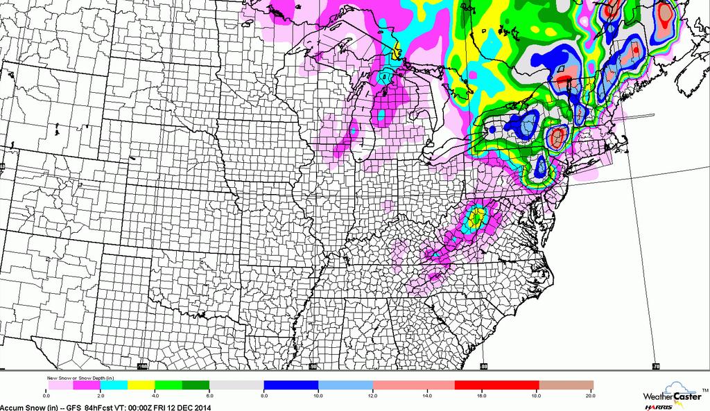
Northeast Snow Potential
The image below suggests the snow potential through the end of the week. Note how little snow there will be along the coast due to warm air/rain mixing in.
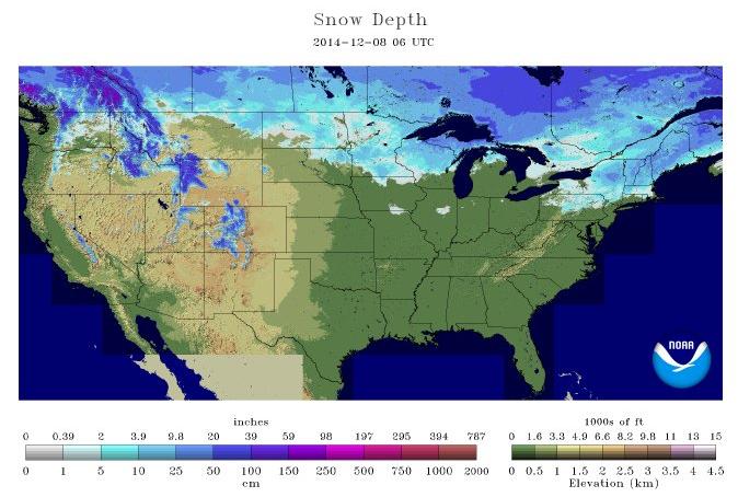
2014 National Snow Depth
According to NOAA's NOHRSC, 17.9% of the nation is currently covered in snow. It appears that with more mild weather on the way in the mid section of the nation, we'll be melting even more snow this week!
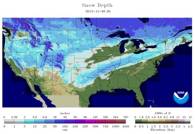
2013 National Snow Depth
Interestingly, last year at this time nearly 60% of the nation was covered in snow, even as far as Texas!
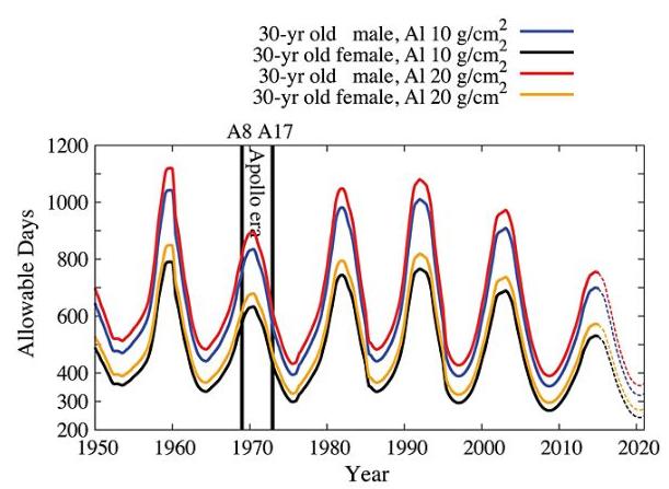
"Growing Peril for Astronauts?"
Here's another interesting read from Spaceweather.com about the growing risk of radiation to astronauts
"NASA's successful test flight of Orion on Dec. 5th heralds a renewed capability to send astronauts into deep space. A paper just published in the journal Space Weather, however, points out a growing peril to future deep space explorers: cosmic rays. The title of the article, penned by Nathan Schwadron of the University of New Hampshire and colleagues from seven other institutions, asks the provocative question, "Does the worsening galactic cosmic ray environment preclude manned deep space exploration?" Using data from a cosmic ray telescope onboard NASA's Lunar Reconnaissance Orbiter, they conclude that while increasing fluxes of cosmic rays "are not a show stopper for long duration missions (e.g., to the Moon, an asteroid, or Mars), galactic cosmic radiation remains a significant and worsening factor that limits mission durations." This figure from their paper shows the number of days a 30 year old astronaut can spend in interplanetary space before they reach their career limit in radiation exposure:"
Read more from Spaceweather.com HERE:
Thanks for checking in and have a great rest of your week! Don't forget to follow me on Twitter @TNelsonWX

No comments:
Post a Comment