This is probably one of the more clever Valentine's notes I've seen in a long time... Thanks to @BeerBrewin for the laugh!

=============
Frozen. The Sequel
By Paul Douglas
Let it go. If Disney built a theme park to celebrate the last ice age it might resemble the scene outside your window right now. A cosmetic coating of crunchy snow & ice; window-whistling winds; a wind chill dipping to -25F at times? After going soft on us in January Old Man Winter is baring his fangs.
Disclaimer: our winter is still a walk in the park, a tame kiddy ride compared to the white knuckle, scream-worthy winter unfolding in Boston, where another blizzard is shaping up for tomorrow. A foot of new snow. No idea where they're going to push the new snow. Boston Harbor?
Maybe we'll pick up some snow in March, which was once our snowiest month of the year (now it's January, at least in theory).
A low-grade El Nino is still whisking big storms well south of Minnesota, keeping us in a cold, dry west/northwest flow aloft. A series of cold fronts bully their way south of the border; more subzero lows by the middle of next week, but no records - nothing out of the ordinary for the latter half of February.
I see hints of a milder, Pacific breeze returning the last few days of February, maybe a rapid thaw in March. On that hopeful, heart-warming note: happy Valentine's Day!
=============
FRIDAY NIGHT: Arctic front arrives. Window-rattling wind and colder! Low: -1. Winds: NW 15-30. Wind Chill: -5F to -15F.
SATURDAY: Blue sky, bitter wind! Wind chill: -15F to -25F early. High: 7. Winds: NW 15-30 early.
SATURDAY NIGHT: Partly cloudy, less wind and colder! Low: -7. Winds: N 5-10.
SUNDAY:Cloudy, up to 1" of fluffy snow. High: 11. Winds: SSE 5-10
MONDAY: Gray skies, not as cold. Wake-up: 4. High: 21.
TUESDAY: Another shot of cold air. Wake-up: 1. High: 9.
WEDNESDAY: Blue sky, no spring fever yet. Wake-up: -5. High: 8.
THURSDAY: Cloudy, breezy, turning milder Wake-up: 3. High: 32.
FRIDAY: Clearing and cooler. Wake-up: 24. High: 27.
=============
This Day in Weather History
February 14th
1923: Black Dust Blizzard ended after two days. Dirt from North Dakota created "dark drifts."
===============
Average High/Low for Minneapolis
February 14th
Average High: 29F (Record 29F set in 1882)
Average Low: 12F (Record -25F set in 1875)
================
Sunrise/Sunrise for Minneapolis
February 14th
Sunrise: 7:15am
Sunset: 5:40pm
================
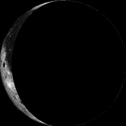
Moon Phase for February 14th at Midnight
3.1 Day After Last Quarter
==================
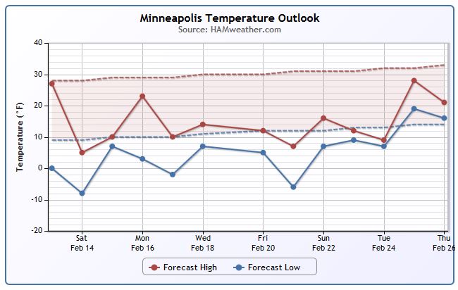
Minneapolis Temperature Trend
Cold weather makes a return this weekend and through much of next week after the passage of an Arctic front Friday night. A near continuous northwest flow keeps temperatures much colder than average through, what appears to be, much of the rest of the month.
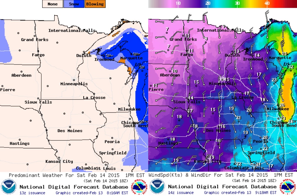
Strong Winds PM Friday/AM Saturday
An Arctic front will slam through the Upper Midwest overnight Friday through Saturday and kick up some major winds. Take a look at what the wind gusts look like by 7AM Saturday! Some locations could see wind gusts approaching 30mph to 40mph, while the south shore of Lake Superior could see wind gusts to near 50mph+
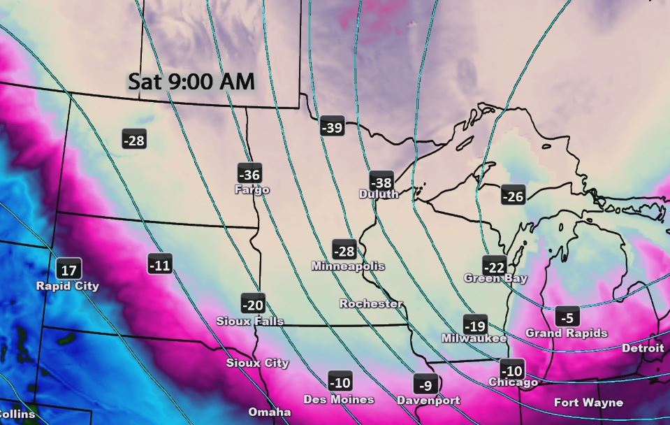
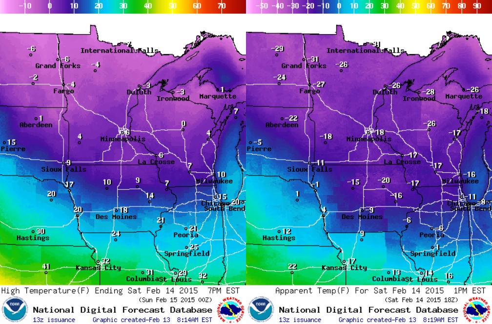
Dangerous Wind Chills PM Friday/AM Saturday
As the Arctic air spills south of the Canadian border and combines with strong gusty winds... AM Saturday wind chills could be extremely cold! Note that there appears to be widespread -20s to near -40s wind chills values across much of the Upper Mississippi Valley! I could even see some locations near the international border drop
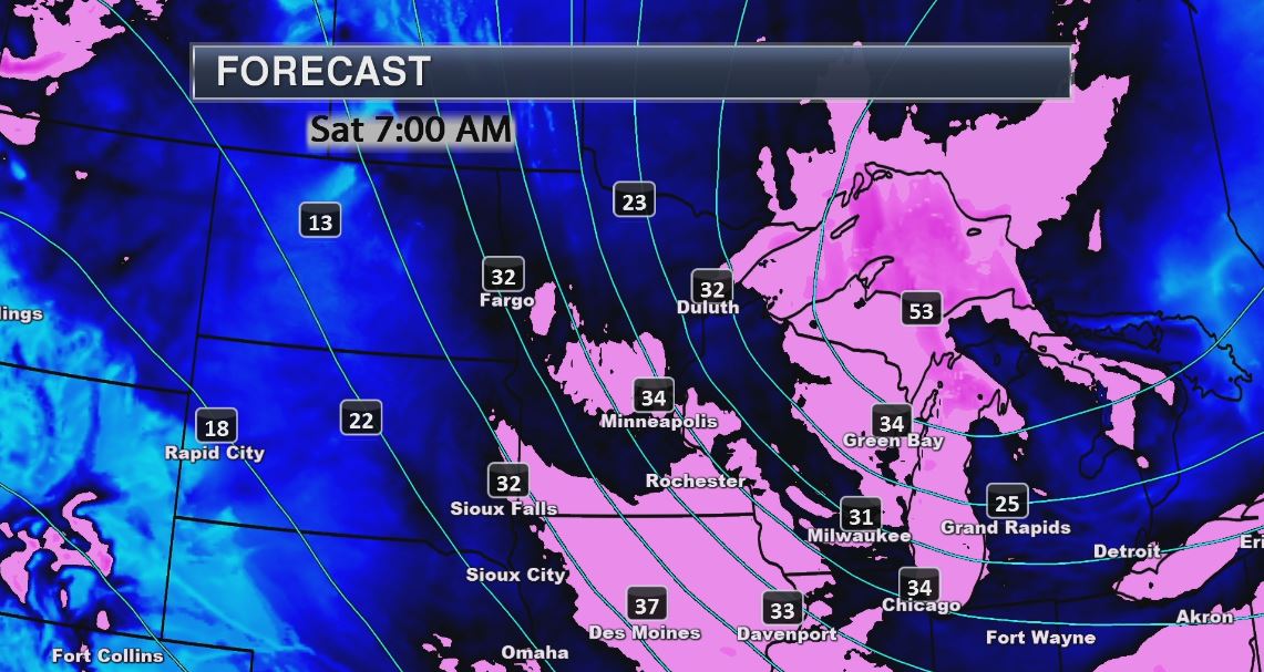
Saturday Weather Outlook
Saturday Weather Outlook Continued
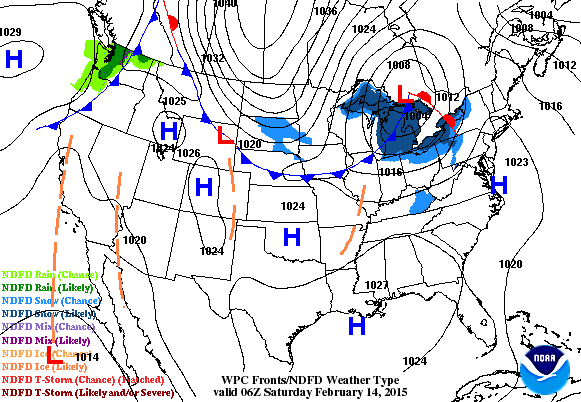
National Weather Outlook
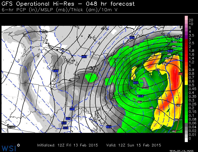
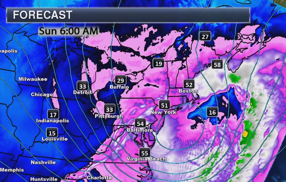
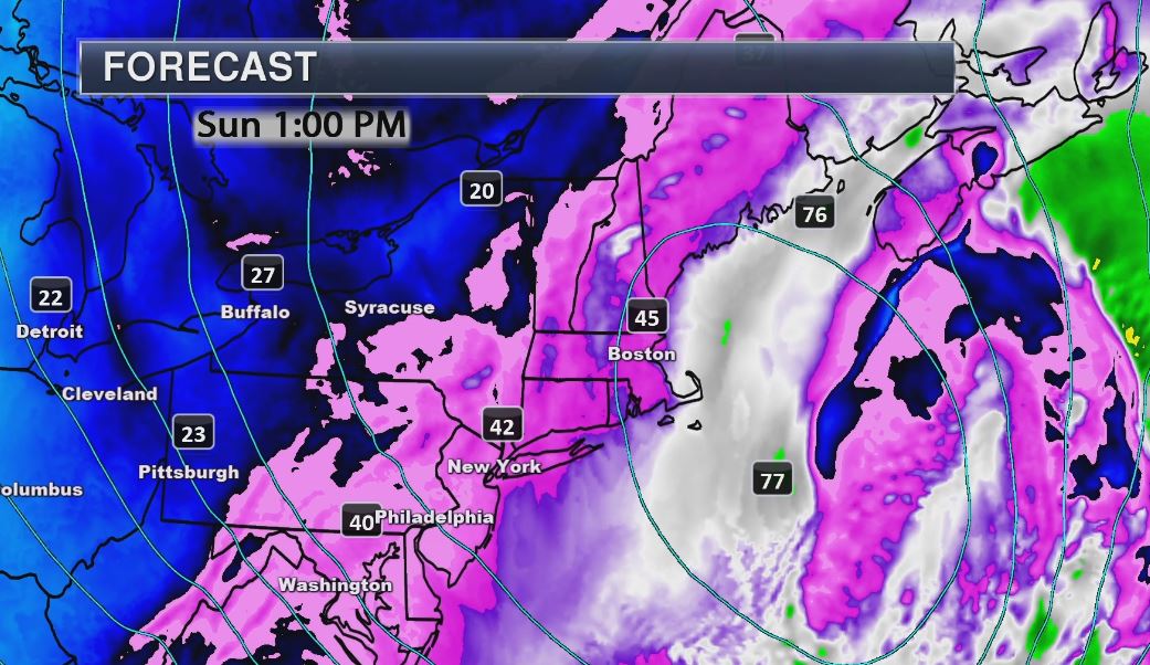
Take a look at the Arctic front that slams through the Upper Midwest/Great Lakes Region through the early weekend. Temperatures will take a significant hit as this cold air spills south the border. Note also how the storm system quickly intensifies as it moves east of the Great Lakes Region. Strong winds and heavy snow will be a major concern for folks in the Northeast Saturday and Sunday.
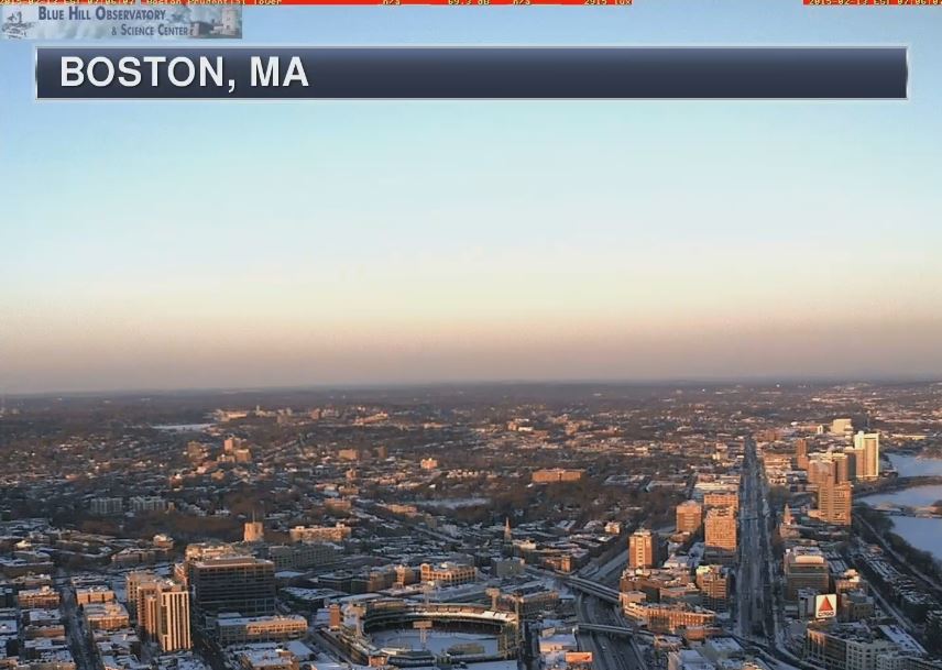
Another Boston Blizzard?
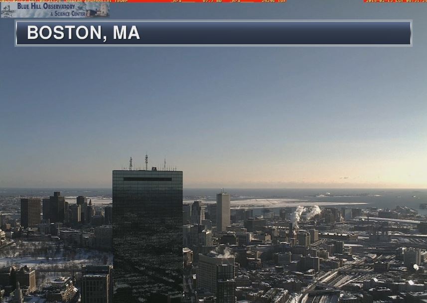
This was the view from Boston, Mass from Friday morning. Note the bright blue sky! Yes, the calm before the storm... Keep in mind that through Friday, Boston has seen 42.3" of snow through the first 13 days of February and it is already their 2nd snowiest February in recorded history! They only need another 1" to tie the snowiest February on record of 43.3" set in January 2005. With the potential of yet another 12" on the way this weekend, Boston will surely set a new record for the snowiest February on record and the only is only half over!
Blizzard Potential
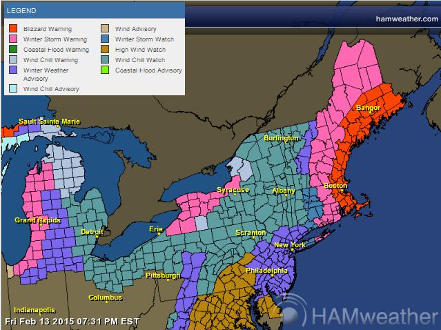
The National Weather Service has issued Blizzard Watches and Winter Storm Watches for a large chunk of the Northeast and mainly along the coast north of New York... which again includes Boston!
...BLIZZARD WATCH REMAINS IN EFFECT FROM SATURDAY EVENING THROUGH SUNDAY EVENING...
* LOCATIONS...EAST COASTAL MASSACHUSETTS.
* HAZARD TYPES...BLIZZARD CONDITIONS...INCLUDING HEAVY SNOW... POOR VISIBILITIES...AND STRONG TO DAMAGING WINDS.
* SNOW ACCUMULATIONS...8 TO 12 INCHES.
* TIMING...SATURDAY EVENING INTO SUNDAY EVENING.
* IMPACTS...LATE SATURDAY INTO SUNDAY BLIZZARD CONDITIONS COULD MAKE TRAVELING DIFFICULT IF NOT IMPOSSIBLE. BLOWING AND DRIFTING SNOW COMBINED WITH STRONG WINDS MAY CREATE PROBLEMS FOR UNCLEARED ROOFS.
* WINDS...NORTH 30 TO 40 MPH WITH GUSTS UP TO 75 MPH. * VISIBILITIES...ONE QUARTER MILE OR LESS AT TIMES.
Blizzard Potential Index
According to our proprietary BPI (Blizzard Potential Index) we're getting significant feedback on the potential for blizzard conditions from near Boston and Cape Cod to Maine during the first half of Sunday...
Tightly Wound Storm
An Arctic front will inject a serious shot of cold air on the backside of this storm, which ultimately will help to intensify this storm system so rapidly! Note the black lines below. Those are isobars and when they get close together, the wind blows quite strongly! Wind speeds could actually reach hurricane force (74mph+) along the coast and just offshore! With heavy snow... this could be a major issue!
Large Wind Field
This is a forecast of what the wind field will look like by AM Sunday... Note how widespread the strong winds will be! However, the strongest winds look to be confined near the coast from the Mid-Atlantic to the Downeast Maine. Again, winds in these areas could approach 50mph to 70mph!
Closer Look...
Note the potential hurricane force (74mph+) wind gusts just offshore!
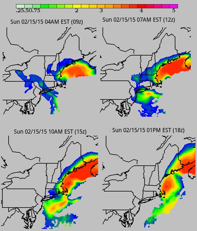
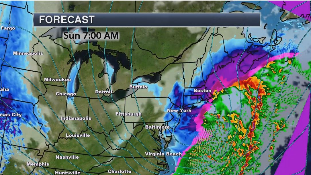
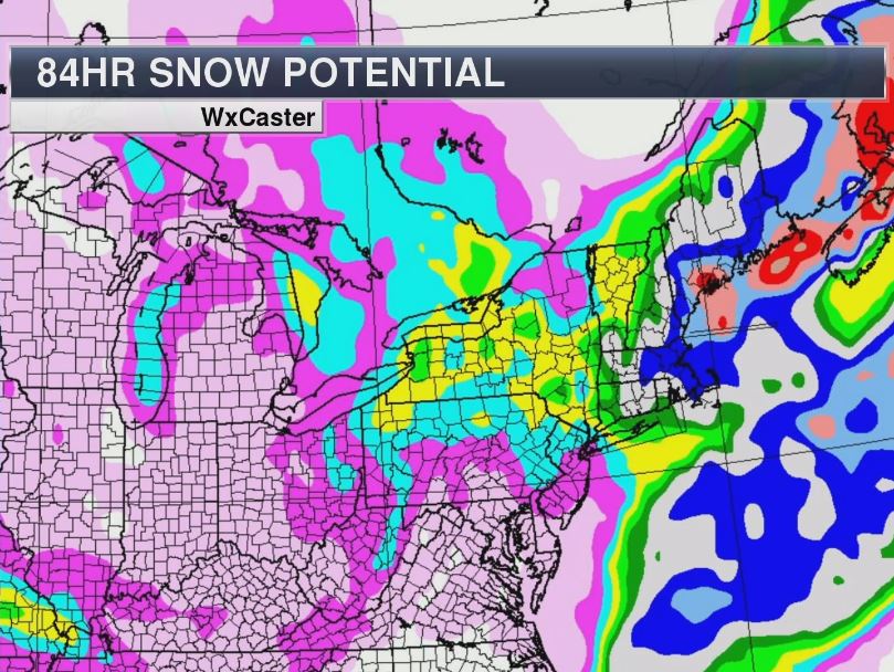
Heavy Snow!
This is what the storm is forecast to look like by AM Sunday with heavy snow falling from near Long Island to Maine
Heavy Snow
Incredibly, snowfall potential in the Northeast looks quite extreme once again; this after nearly 60" to 70" in spots over the past 2 to 3 weeks.
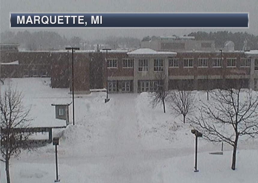
Marquette, MI Blizzard
This was the view from Northern Michigan University early Friday as snow started falling on the campus. Marquette in under a Blizzard Warning thru 10pm Saturday!
...BLIZZARD WARNING REMAINS IN EFFECT FROM 1 AM TO 10 PM EST SATURDAY... HAZARDOUS WEATHER...
* WINDS WILL INCREASE OUT OF THE NORTHWEST THIS EVENING BEHIND A STRONG COLD FRONT...WITH GUSTS UP TO 30 MPH. THEN AS WINDS SHIFT TO THE NORTH LATE TONIGHT...WINDS OF 25 TO 35 MPH WITH GUSTS TO 50 MPH WILL COMBINE WITH LAKE EFFECT SNOW TO PRODUCE SIGNIFICANT BLOWING SNOW AND WHITE OUT CONDITIONS ALONG LAKE SUPERIOR THROUGH SATURDAY AFTERNOON. INLAND FROM LAKE SUPERIOR...WINDS WILL BE 15 TO 25 MPH WITH GUSTS TO 35 MPH LATE TONIGHT INTO SATURDAY.
* LOW WIND CHILLS OF 25 TO 35 BELOW ZERO ARE EXPECTED LATE TONIGHT THROUGH SATURDAY.
* AFTER LIGHT SNOW TODAY...LAKE EFFECT SNOW WILL INCREASE TONIGHT. STORM TOTAL SNOWFALL OF 4 TO 9 INCHES IS EXPECTED ALONG LAKE SUPERIOR BY SATURDAY NIGHT...WITH THE HEAVIEST SNOW OCCURRING LATE TONIGHT INTO SATURDAY MORNING OVER EASTERN MARQUETTE AND WESTERN ALGER COUNTIES. LESS THAN 2 INCHES OF SNOW IS FORECAST OVER SOUTHWEST MARQUETTE COUNTY...NEAR WITCH LAKE AND ARNOLD.
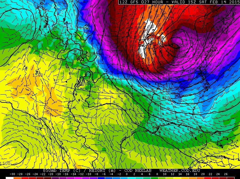
Cold Temperatures
This is what temperatures look like a few thousand feet off the ground. Note the significant blob of Arctic air (purples, reds and whites) crashing south of the international border by Saturday. This will quickly dive southeast along with the Arctic front.
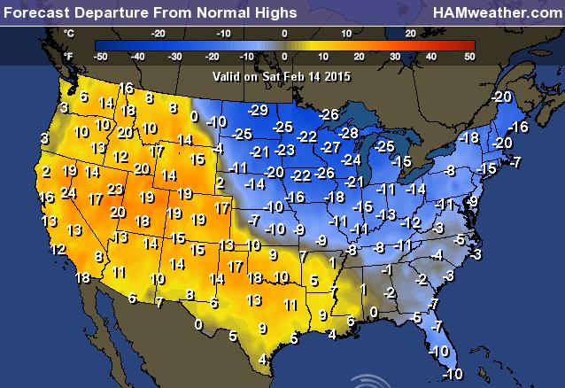
Highs From Average Saturday
This is what the departure from average high map looks like for Saturday. Note that the blob of Arctic air mention above will drag temperatures down into the -10F to near -30F below average! across the Midwest/Great Lakes Region.
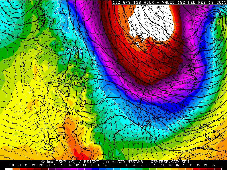
Cold Temps
Extended model runs suggest yet another blob of cold Arctic air heading south of the border into the middle part of next week. This one however looks potentially a little more widespread across the eastern U.S..
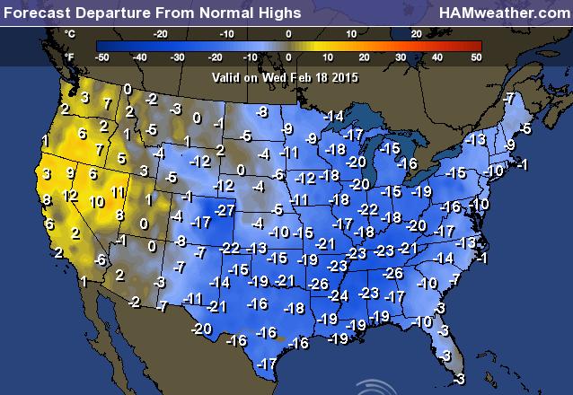
Highs From Average Wednesday
The cold air mass mentioned above for next Wednesday looks to bring significantly colder air to quite a bit more of the nation. In fact, readings across much of the eastern two-thirds of the nation look to be nearly -10F to 20F below average!
Thanks for checking in and have a great weekend ahead! Don't forget to follow me on Twitter @TNelsonWX

No comments:
Post a Comment