A Cold Bias
By Paul Douglas
We've done a pretty good job engineering weather out of our lives, rendering the elements outside irrelevant. From furnaces to heated car seats we've invented new ways to thumb our nose at Old Man Winter.
But a blizzard? You're unable to distinguish sky from ground; high-velocity snowflakes feel like sandpaper on your skin as you stumble around snowy quicksand. Your yard becomes unfamiliar, enemy territory as you try to navigate back to safety.
Boston is experiencing another blizzard Sunday morning; some locals possibly questioning the wisdom of living so close to an Atlantic Ocean that super-sizes some of the storms tracking up the coast.
While we stare out at 1 inch of snow on the ground in the metro area; a far cry from the 13 inches last year at this time. The next 2 weeks will trend colder than average: moderately unpleasant, but not quite polar. The mercury dips below zero 2 or 3 nights later this week but do your homework. No school-closing cold waves are in sight.
It's obviously cold enough for snow but this same dry (west/northwest) pattern lingers into early March; not ripe for serious storms.
Boston may see another big snowstorm next weekend. Insult to injury.
===============
SATURDAY NIGHT: Clouds thicken, less wind and colder! Low: -7. Winds: NNE 5. Wind Chill: -10F to -15F
SUNDAY:Light snow likely, light coating of light fully snow. High: 12. Winds: SSE 5-10. Wind Chill: -10F to -15F
SUNDAY NIGHT: Chance of light snow early. Low: 4. Winds: SSW 5-10. Wind Chill: -5F to -10F
MONDAY: Gray skies, not as cold. High: 20. Wind: Turns WNW 5-10
TUESDAY: Another shot of cold air. Wake-up: 1. High: 9.
WEDNESDAY: Blue sky, no spring fever yet. Wake-up: -6. High: 4.
THURSDAY: Cloudy, breezy, turning milder Wake-up: -2. High: 12.
FRIDAY: Clearing and cooler. Wake-up: 4. High: 21.
SATURDAY: Chance of light snow, warmer. Wake-up: 12. High: 28.
=================
This Day in Weather History
February 15th
1921: Early blast of spring weather invades Minnesota. Thunderstorms were reported across the southern portion of the state. Winona had a high of 67.
===============
Average High/Low for Minneapolis
February 15th
Average High: 29F (Record: 63F set in 1921)
Average Low: 13F (Record: -25F set in 1875)
=================
Sunrise/Sunset Times for Minneapolis
February 15th
Sunrise: 7:13am
Sunset: 5:42pm
=================
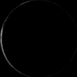
Moon Phase for February 15th at Midnight
2.7 Days Before New Moon
====================
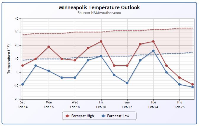
Minneapolis Temperature Trend
Cold weather looks to persist has we head through the end of February. Note that temperatures looks to stay well below average through much of the week ahead. We could certainly see several day with lows below zero too!
====================
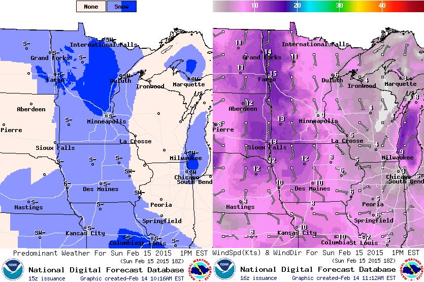
Sunday Weather Outlook
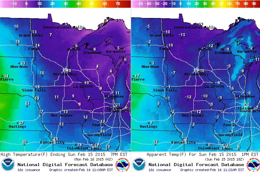
It looks like another cold day Sunday, but not nearly as windy as it was on Saturday! Daytime highs (image on left) will warm into the single digits and teens across the state after a VERY cold start to the day. Feels like temperatures (image on right) will still be in the teens below zero by midday/early afternoon.
Sunday Weather Continued...
A fast moving clipper system will slide through the region on Sunday bringing light snow back into the picture. Keep in mind that due to the cold temperature, the snow will be light and fluffy and it could add up to 1" across the northern half of the state.
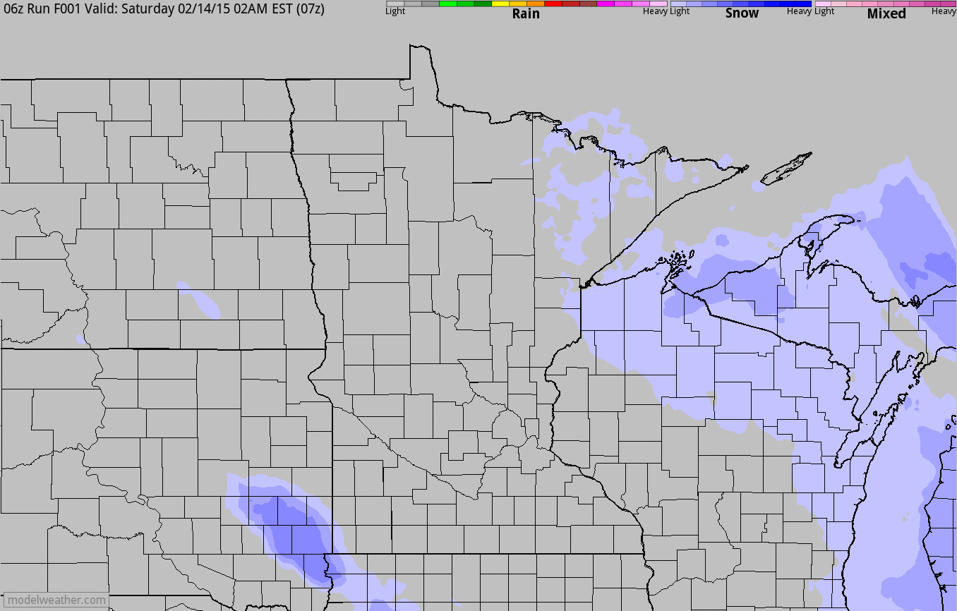
Sunday Snow Potential
Another fast moving clipper system will brush the region with a little light snow on Sunday. Due to cold temperature, this snow is expected to be very light and fluffy and could add up to 1" in some areas, mainly across the northern half of the state. My concern; remember all that ice we had about a week ago? There will likely be icy spots in driveways, sidewalks, streets and parking lots that get covered up on Sunday. This may make for a hidden slipping danger!
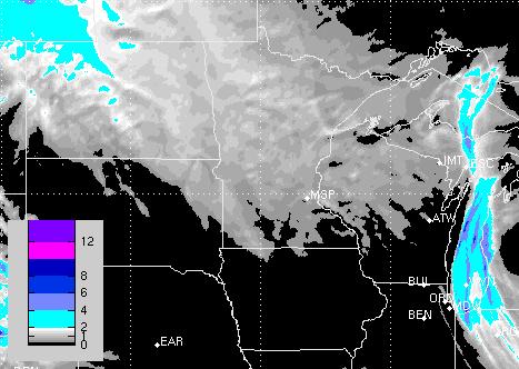
Sunday Snow Potential
Here's a peak at what we could be dealing with in terms of snow potential on Sunday. Note that there doesn't appear to be much accumulation across the state. I could see up to 1" possible in some areas across the northern half of the state. The farther south you go, snowfall amounts will be much less to nothing at all.
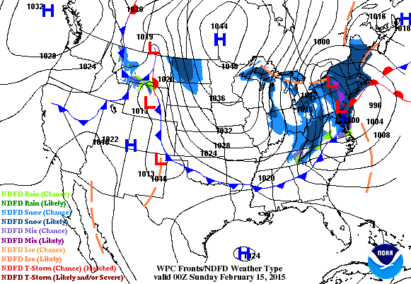
National Weather Outlook
Take a look at that storm system in the Northeast! Wild weather including heavy snow and near hurricane force wind gusts will be associated with that thing as it roars through the region late weekend/early next week. Also note the developing system across the southern tier of the nation... this will threaten to bring a wintry mix of freezing rain, sleet and snow to some areas, which could cause some major travel concerns early next week!
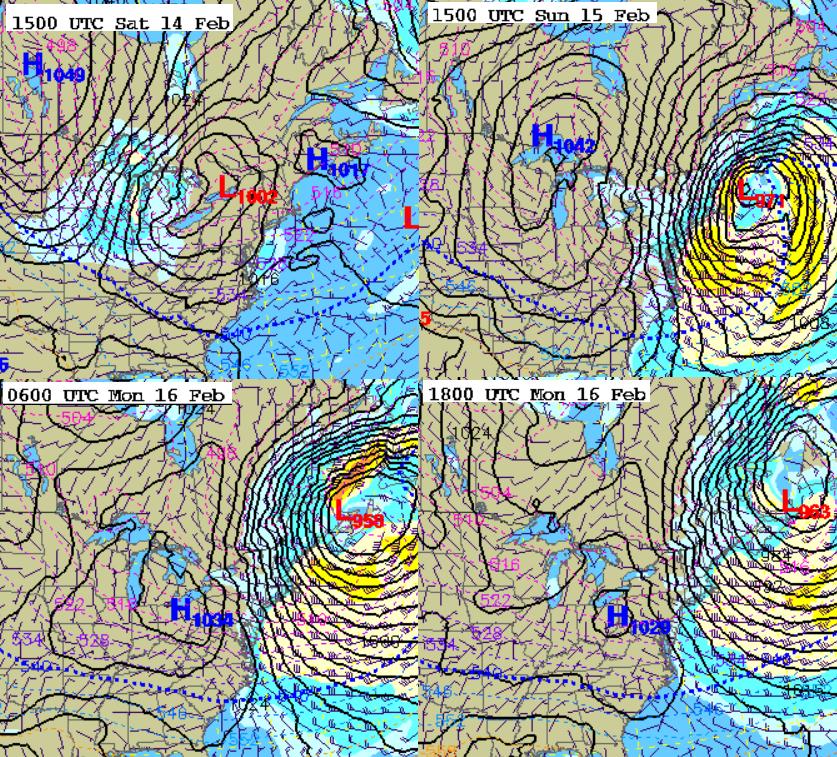
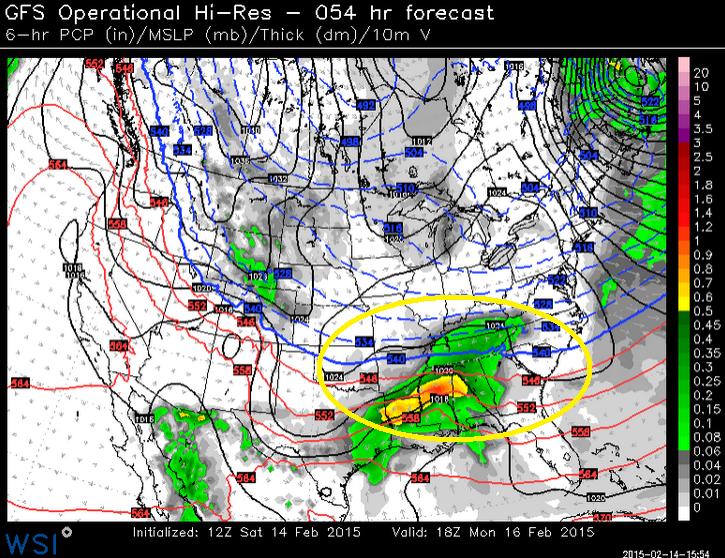
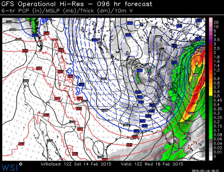
"Bombogenesis"
Bombogenesis is a term given to a storm system that rapidly intensifies by 24mb within a 24 hour period. Take a look at the storm progression in to images below. From AM Saturday to AM Sunday the central pressure of the storm is expected to drop nearly by 30mb within that time period! Interestingly, the storm COULD bottom out with a central pressure around 955mb similar to that of Hurricane Eduoard during the 2014 Atlantic Hurricane Season!
Boston Blizzard
The perverbial calm before the storm on Friday gave way to snowy conditions through the day Saturday. Snow and wind intensities will quickly ramp up overnight Saturday thru Sunday with wind gusts approaching 40mph-50mph into Sunday! With up to another foot of snow expected for Boston, heavy winds are expected to create blizzard conditions through AM Monday across the coastal communities of the Northern New England States!
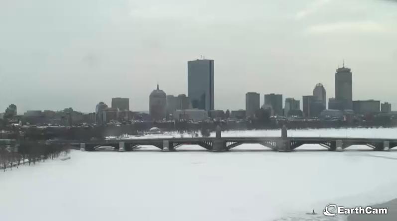
Check the latest Earthcam.com from Boston HERE:
(Image captured midday Saturday)
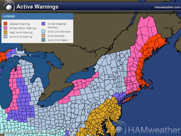
Latest Winter Weather Headlines
Take a look all the weather headlines that have been posted for the Northeast. From Blizzard Warnings (red) to High Wind Warnings (brown) and Wind Chill Warnings (dull blue), the latest storm system will have significant and wide reaching impacts across the Northeast through early next week.
Here's the latest from the National Weather Service out of Boston, MA:
...BLIZZARD WARNING REMAINS IN EFFECT FROM 7 PM THIS EVENING TO 7 AM EST MONDAY... ...WIND CHILL WARNING REMAINS IN EFFECT FROM 4 PM SUNDAY TO 8 AM EST MONDAY...
* LOCATIONS...EAST COASTAL MASSACHUSETTS.
* HAZARD TYPES...BLIZZARD CONDITIONS...INCLUDING HEAVY SNOW... POOR VISIBILITIES...AND STRONG TO DAMAGING WINDS. DANGEROUSLY LOW WIND CHILL VALUES.
* SNOW ACCUMULATIONS...10 TO 14 INCHES.
* TIMING...SNOW ARRIVES THIS AFTERNOON AND CONTINUES INTO THIS EVENING. AFTER A BRIEF LULL LATE THIS EVENING...MORE SNOW ARRIVES LATE TONIGHT. THE WORST CONDITIONS ARE EXPECTED TO BE LATE TONIGHT INTO EARLY MONDAY MORNING.
* IMPACTS...TRAVEL WILL BECOME NEARLY IMPOSSIBLE AND POTENTIALLY LIFE THREATENING DUE TO WHITEOUT CONDITIONS AND BITTERLY COLD WIND CHILLS. CONDITIONS WILL REMAIN DANGEROUS FOR TRAVEL WELL INTO SUNDAY DUE TO BLOWING AND DRIFTING SNOW...REDUCED VISIBILITY AND DANGEROUSLY COLD WIND CHILLS. POWER OUTAGES CAN BE EXPECTED AT SOME LOCATIONS DUE TO VERY STRONG WINDS.
* WINDS...NORTHWEST 25 TO 35 MPH WITH GUSTS UP TO 60 MPH.
* VISIBILITIES...ONE QUARTER MILE OR LESS AT TIMES.
*WIND CHILL READINGS...AS LOW AS 28 BELOW.
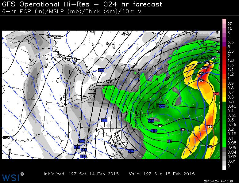
AM Sunday Weather Outlook
The height of the storm appears to be early Sunday as heavy snow and strong winds will be pelting the Northeast. The image below suggests the storm location and intensity by 7AM ET Sunday. Note how close the isobars (black lines) are together... this tight pressure gradient will allow for a large and intense wind field; winds will likely gust to 40mph-60mph along the coast. Power outages may be a big concerns, especially with the cold air moving in behind the storm!
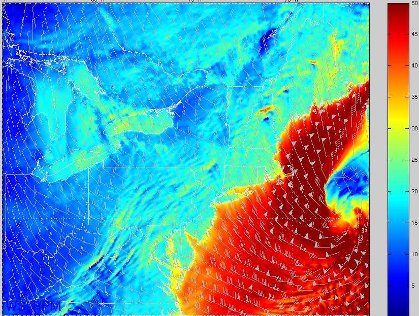
Strong Winds in the Northeast
This is what the surface wind field looks like by midday Sunday. Note the reds, mainly offshore on the western edge of the storm... these are winds of nearly 40mph to 60mph, which will likely impact folks near the coast! Again, power outages could be a major concern with this storm, especially with the temperature drop expected into early next week!
Stormy Pattern Continues
Take a look at this little bugger early next week. Moisture will be spreading northeast into a cold airmass, which will create some wintry precip concerns. There's a chance of snow, sleet and freezing rain from the Middle Mississippi Valley to the Ohio/Tennessee Valley and the Mid-Atlantic Region. Interestingly, this storm looks to take aim on the Northeast once again with more snow potential by midweek!
Another Snow Event For the Northeast?
Say in ain't snow... This is unreal! Extended model runs are suggesting yet another potential snow event for the Northeast by the middle of next week... stay tuned for more! Note the big plunge of cold weather that looks to be invading much of the eastern two-thirds of the nation during this time!
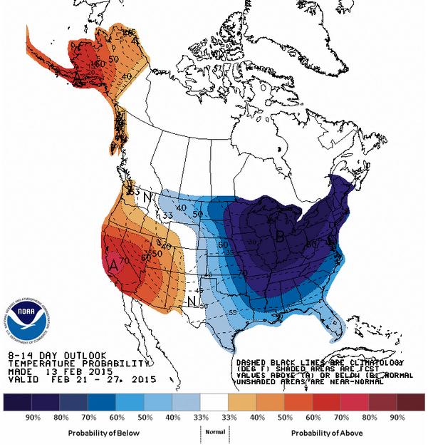
National Extended Temperature Outlook
According to NOAA's CPC, the 8 to 14 day temperature outlook looks to stay much colder than average across the eastern two-thirds of the nation through the end of the month. However, the western third of the nation looks and especially California, looks to stay much warmer than average!
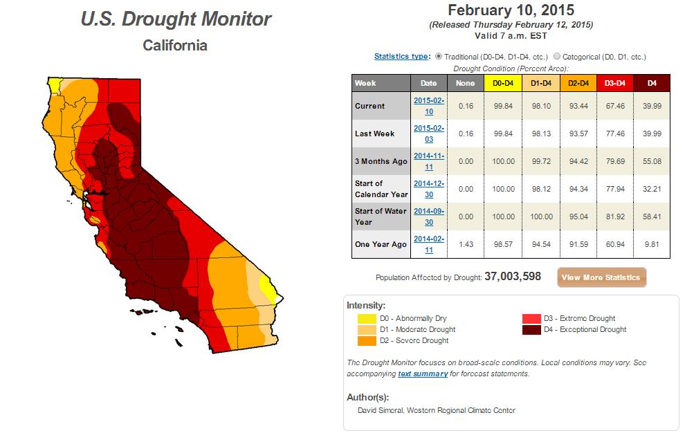
California Drought
According to the U.S. Drought Monitor, as of February 10th, nearly 40% of California was considered to be in an EXTREME DROUGHT! The good news is that this is less than what it was 3 months ago, but we still need A LOT more moisture!!
"According to the California Department of Water Resources, California’s snowpack (snow water equivalent) is currently at 27% of normal. On a more positive note, runoff associated with the precipitation event (1 week ago) provided the addition of approximately 500,000 acre feet of inflow to the four major reservoirs (Folsom, Oroville, Shasta, and Trinity) in northern California. In response to the storm, a one-category improvement was made to areas of Extreme Drought (D3) in northwestern California as well as in the Santa Cruz Mountains (between San Francisco and Santa Cruz) and in the northern half of the Santa Lucia Range along the Central Coast. No changes were made on the map in the Sierra Nevada Range because snowpack conditions remain well below normal."
"NASA: The U.S. Faces "Mega Drought" Not Seen in 1,000 Years"
Check out this story from Science.Mic about the record-shattering drought that is currently gripping California:
"Scientists have bad news for West Coasters in the grips of the worst drought in decades: The worst is yet to come. The record-shattering drought currently gripping California is a light crudité compared to the "mega-drought" that's expected to envelop the Southwest and Great Plains over the next 35 years, NASA revealed Thursday. The full study, ominously named "Unprecedented 21st century drought risk in the American Southwest and Central Plains," was published in Science Advances."
See more from Science.Mic HERE:
(Image credit: Getty Images via Science.Mic)
Thanks for checking in and have a great rest of your weekend! Don't forget to follow me on Twitter @TNelsonWX

I really like this valuable information and Thanks for sharing such great information. Please keep it up and I am waiting for new post here.
ReplyDeleteGlobal Warming Times