Cold vs. Snow?
By Todd Nelson
Not sure what I'd rather be dealing with at this point... our face-numbing, sub-zero wind chills or the extreme snow in the Northeast.
The latest storm to impact the New England states dropped 1ft. to nearly 2ft. with high wind gusts from 50mph to nearly 70mph! According to the National Weather Service out of Boston, as of midday Sunday, they have now seen nearly 59" of snow this February; The snowiest month in recorded history! Incredibly, they have nearly 4ft of snow on the ground, which is the greatest snow depth in 130yrs. of record keeping. Suddenly, I feel like I can handle a few more days of bone-chilling weather, how about you?
Another wintry blast will drop nearly a foot of snow across parts of Kentucky today with up to 0.50" ice expected across parts of the Tennessee Valley. Meanwhile, we sit nearly 14" below average snowfall for the season in the Twin Cities with a meager 1" of snow depth. Last year at this time, we had 14" of snow on the ground!
We won't see much in terms of snow this week, but we'll have to continue bundling up as we battle another several days bone-chilling temps. It appears that the bitter cold weather breaks by next week. -Todd Nelson
=============
SUNDAY NIGHT: A few flakes early, otherwise, mostly cloudy. Low: 4. Winds: SSW 5-10. Wind Chill: -5F to -10F
MONDAY: Grey skies, a few flakes? High: 19. Wind: Turning WNW 10-15 late.
MONDAY NIGHT: Mostly cloudy and colder. Low: 1. Winds: NW 10. Wind Chill: -10F to -15F
TUESDAY: Another shot of cold air. High: 8. Winds: WNW 10-15. Wind Chill: -10F
WEDNESDAY: Cold sunshine, AM wind chill: -20F. Wake-up: -6. High: 4.
THURSDAY: Icy sunshine, less wind. Wake-up: -9. High: 7.
FRIDAY: Clipper arrives, light snow chance. Wake-up: 7. High: 20.
SATURDAY: Breezy, more sun. Wake-up: 7. High: 20.
SUNDAY: More clouds, not as cold. Wake-up: 6. High: 22.
==============
This Day in Weather History
February 16th
1981: Great warm-up across Minnesota. Highs in the 50's and 60's common. 5 daily high records broken in a row in the Twin Cities. Many records were also broken statewide.
1903: A temperature of -59 was recorded at Pokegama Dam, tying the state record low at that time. It would not be broken for another 93 years.
================
Average High/Low for Minneapolis
February 16th
Average High: 29F (Record: 60F set in 1981)
Average Low: 13F (Record: -26F set in 1936)
================
Sunrise/Sunset Times for Minneapolis
February 16th
Sunrise: 7:12am
Sunset: 5:43pm
=================
Moon Phase for February 16th at Midnight
1.7 Days before New Moon

=================
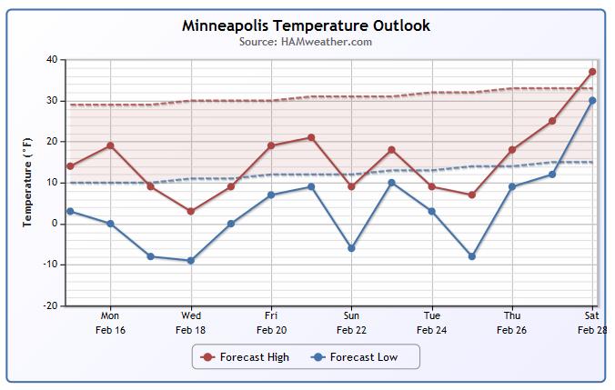
Minneapolis Temperature Trend
Cold weather continues through much of the rest of February! Take a look at what extended model runs are suggesting through the next couple of weeks. For the most part, it appears we stay well below average with a chance of milder temperatures 'finally' by the end of the month/start of March. By the way, February is the last month of Meteorological Winter, which is defined as the coldest 3 months on average for the northern hemisphere. That mean, we're only 2 weeks until Meteorological Spring!
======================
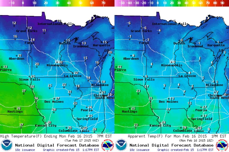
Monday Weather Outlook
Temperatures on Monday will warm into the 10s and 20s across the state, however, winds will make it feel more like the single digits above and below zero for much of the day.
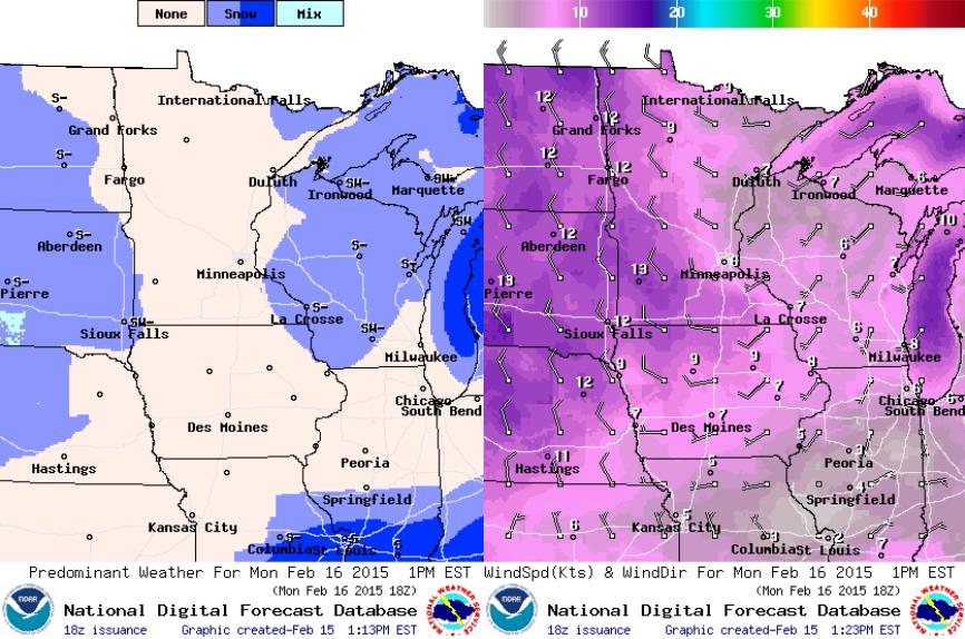
Monday Weather Outlook
Our persistent northwest flow continues with fast moving, moisture starved clipper systems rolling through the area. Each one that passes brings a light snow chance of another shot of cold air. We'll be between clipper systems on Monday with winds picking up a little more during the afternoon out of the northwest. Temperatures will take another nosedive on Tuesday with highs struggling to get back into the single digits above zero for much of the state.
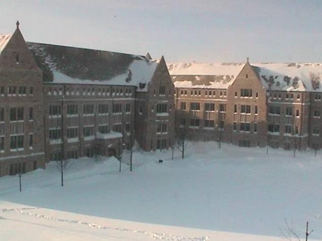
Boston Blizzard
This was the view from Boston College late Sunday afternoon as most of the snow had wrapped up. Another 12" to nearly 24" was reported across parts of the Northeast with wind gusts of 40mph to nearly 70mph were recorded. According to the NWS out of Boston, Mass. as of Sunday afternoon, Boston had seen 58.5" of snow for the month of February setting a record for the snowiest month on record! The previous record was 43.3" set in January of 2005!
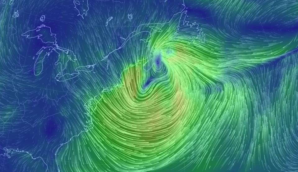
Northeast Storm Wrap Up
Take a look at the wind field from late Sunday afternoon across the Northeast. Note how widespread the strong winds were as it continued moving northeast...
Take a look at the latest storm summary from NOAA's HPC HERE:
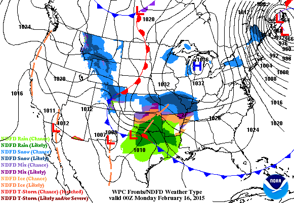
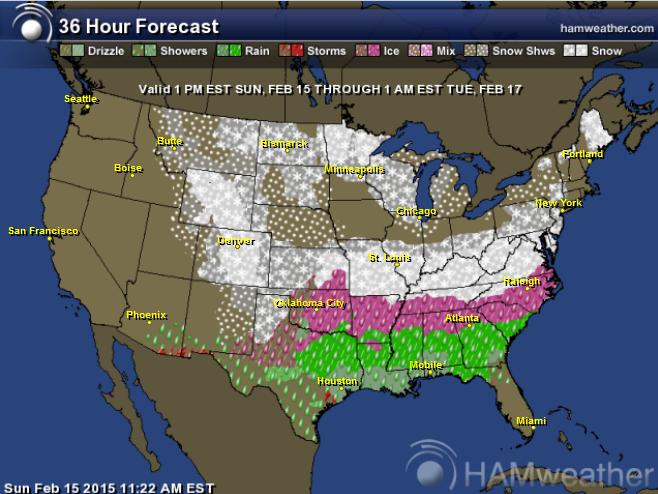
National Weather Outlook
It really has been a busy last few weeks with winter storm after winter storm affecting the eastern part of the country. Weather conditions in the Northeast have been the busiest, but folks from the Middle Mississippi Valley to the Mid-Atlantic Region will now get a little taste of the action. From heavy rain across the Gulf Coast States to freezing rain, sleet and snow across the Tennessee/Ohio Valley on east, this will be a significant storm causing major travel concerns
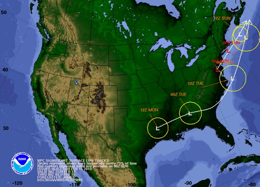
Storm Track
According to NOAA's HPC, the storm track will move from the Lower Mississippi Valley on Monday to just off the New England Coast by the weekend. Due to cold air in place over the eastern two-thirds of the country, wintry precip will be a big issue with this system. Most of the wintry precip will occur on the northern/western flank of the storm track as it moves northeast this week.
National Weather Outlook
YIKES! Look at the wintry precip that looks to cross through the middle part of the country to the East Coast.
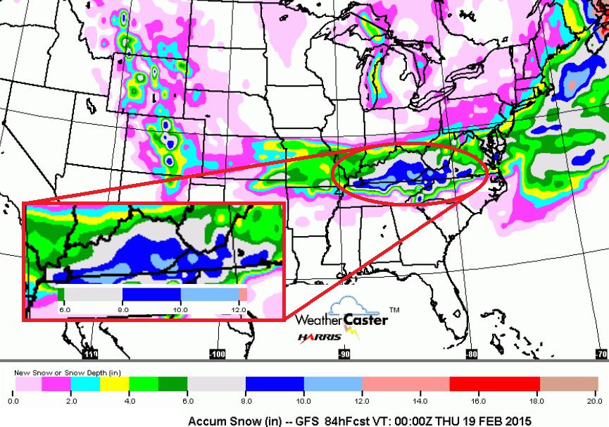
Snow Potential
This WILL be a significant storm for folks across parts of the Ohio/Tennessee Valley. Snowfall amounts of 6" to upwards of 12" can't be ruled out.
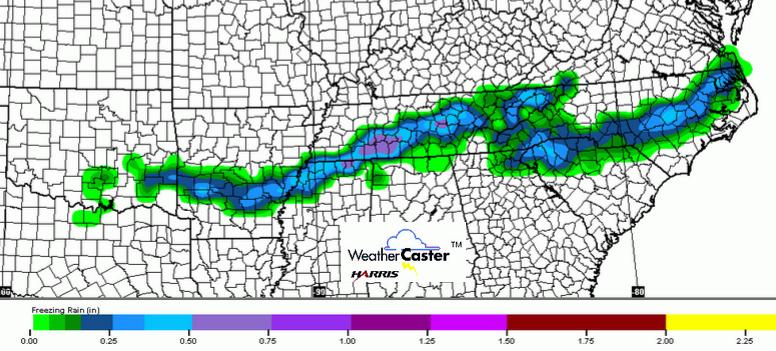
Freezing Rain Potential
Take a look at the freezing rain potential through the early week timeframe. A thin band of fairly significant freezing rain/ice can't be rule out from near Memphis, TN to near Norfolk, VA. Significant travel concerns will be felt here too!
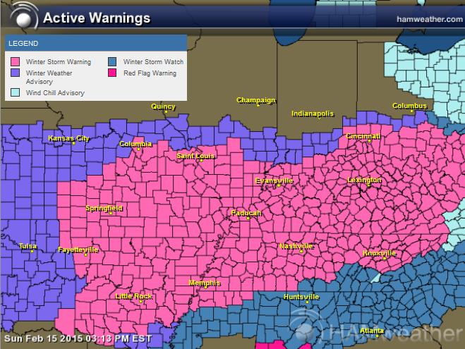
Winter Weather Headlines
Take a look at how many folks will be under winter weather headlines through the early week timeframe. Here's the latest from the National Weather Service out of Louisville, KY
...WINTER STORM WARNING REMAINS IN EFFECT FROM 7 PM EST /6 PM CST/ THIS EVENING TO 1 AM EST /MIDNIGHT CST/ TUESDAY... A WINTER STORM WARNING REMAINS IN EFFECT FROM 7 PM EST /6 PM CST/ THIS EVENING TO 1 AM EST /MIDNIGHT CST/ TUESDAY.
* TIMING: BEGINNING LATE THIS EVENING. HEAVIEST SNOW MONDAY MORNING. ENDING MONDAY EVENING.
* MAIN IMPACT: DANGEROUS TRAVEL CONDITIONS...ESPECIALLY MONDAY MORNING WHEN THE HEAVIEST SNOWFALL IS FORECAST.
* ACCUMULATIONS: 4 TO 7 INCHES OVER SOUTHERN INDIANA. 6 TO 10 INCHES NORTH-CENTRAL KENTUCKY. 8 TO 12 INCHES SOUTH OF THE WESTERN KENTUCKY AND BLUEGRASS PARKWAYS. LOCALLY HIGHER AMOUNTS...ESPECIALLY IN KENTUCKY.
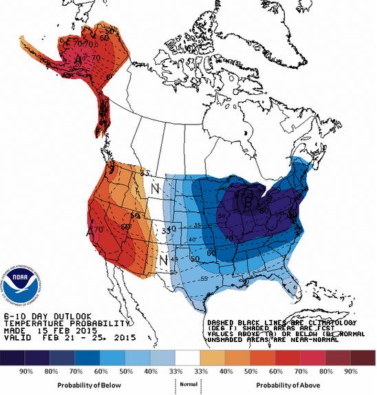
Extended Temperature Outlook
According to NOAA's CPC, the 6 to 10 day temperature outlook (through February 25th) keeps the eastern half of the country colder than average. However, the western third of the country, including Alaska stay warmer than average!
Thanks for checking in and have a great week ahead! Don't forget to follow me on Twitter @TNelsonWX

No comments:
Post a Comment