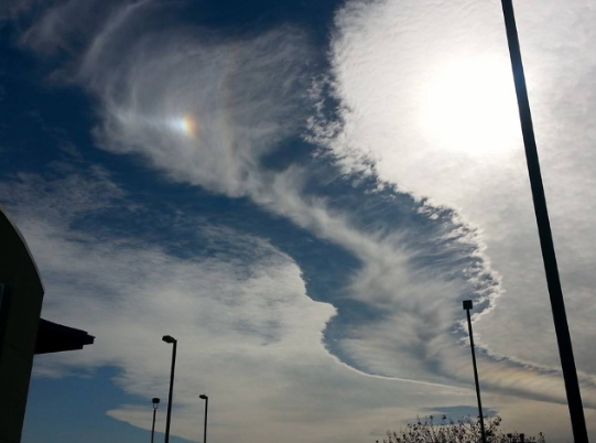
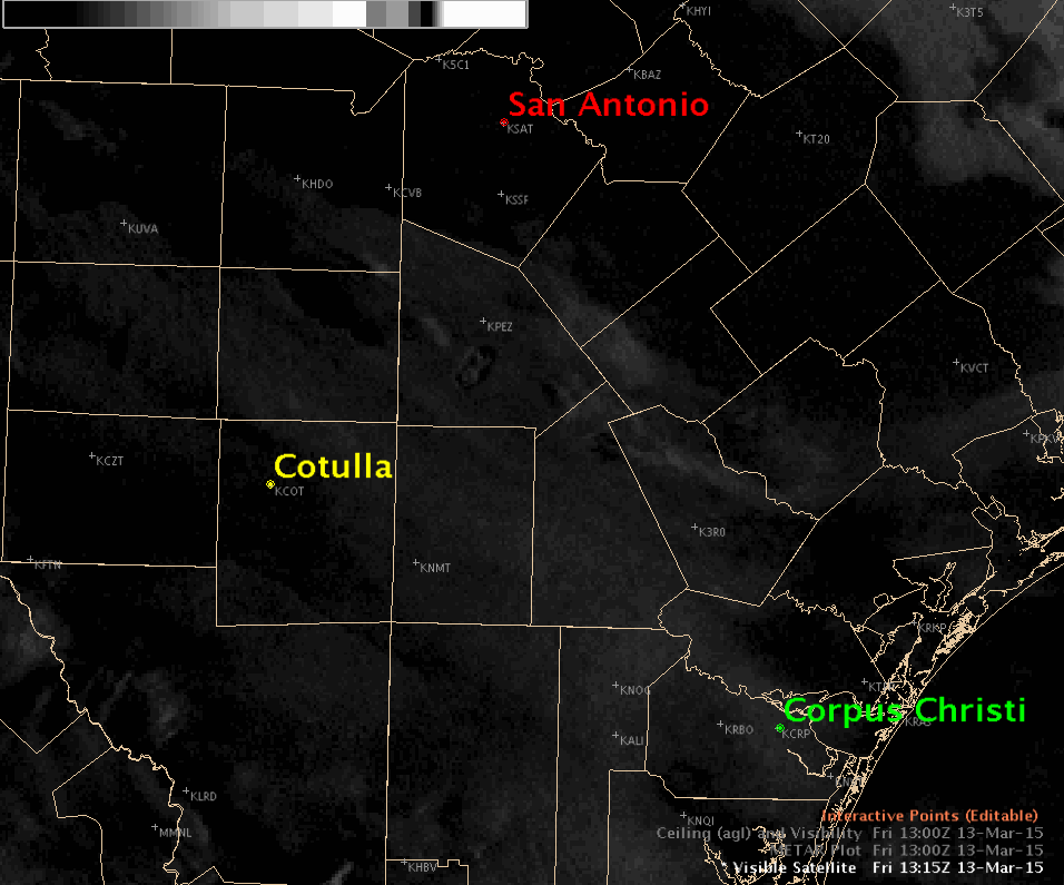
The Mystery of the "Cloud Hole Punch"
The National Weather Service in San Antonio, TX went into meteorological investigation mode on Friday as several pictures/reports of strange clouds came rolling in. Using their meteorological expertise and aid of FlightAware.com, they were able to determine that an airplane at approximately 24,000ft was indeed the cause of the Hole Punch clouds over Central Texas/San Antonio. Good work @NWSSanAntonio !!

===================
Weather Relativity
By Paul Douglas
By Paul Douglas
We are strange, fickle creatures. How can 60F be a cold front in September but a wondrous warm front in mid-March? It's not rocket science, it's relativity. We are constantly comparing weather with what has come before, trying to make sense of today's snapshot of the atmosphere. Buffeted by forces beyond our control, one of the few effective coping skills we can employ is grim perspective. "Hey, this is highly unusual for mid-March!"
We have reliable weather records dating back 130 years; slightly sketchy pioneer data goes back to the 1830s. "Climatologists explain the impacts of climate so that society can plan its activities, design its buildings and infrastructure, and anticipate the effects of adverse conditions" says the National Drought Mitigation Center.
By any measure the next 36 hours will be highly unusual; nearly 30 degrees above average. If the sun stays out a strong south wind may transport the mercury close to 70F Sunday, again tomorrow before colder air plows southward. 40s and 50s return later this week; a cold rain Thursday, again Sunday.
What's on my mind? Spring break and drought. At some point this dry spell will break. Probably with a muddy splash.
=================
SATURDAY NIGHT: High, thin clouds moving in. Nothing rough. Low: 39. Winds: W 5.
SUNDAY: Some sun. Breezy and mild. High: 70 (Record: 69F set in 1827). Winds: S 10-15
SUNDAY NIGHT: Mostly cloudy. Low: 47. Winds: W 5-10.
MONDAY: Mild start, then gusty and cooler with a slight rain chance. High: 59. Winds: N 10-15.
TUESDAY: Cool sunshine, winds ease.. Wake-up: 30. High: 46.
WEDNESDAY: Fading sun, milder than average. Wake-up: 26. High: 49.
THURSDAY: Cloudy with rain showers. Wake-up: 37. High: 43.
FRIDAY: Spring Begins! Partial clearing, drying out. Wake-up: 33. High: 49.
SATURDAY: Mostly cloudy, probably dry. Wake-up: 35. High: 43.
=================
This Day in Weather History
March 15th
March 15th
1941: "Ides of March Blizzard." Winds reached hurricane force at Twin Cities. 32 people died.
================
Average High/Low for Minneapolis
March 15th
March 15th
Average High: 41F (Record: 69 set in 1927)
Average Low: 24F (Record: -7 set in 1897)
Average Low: 24F (Record: -7 set in 1897)
================
Sunrise/Sunset Times for Minneapolis
March 15th
March 15th
Sunrise: 7:25am
Sunset: 7:19pm
Sunset: 7:19pm
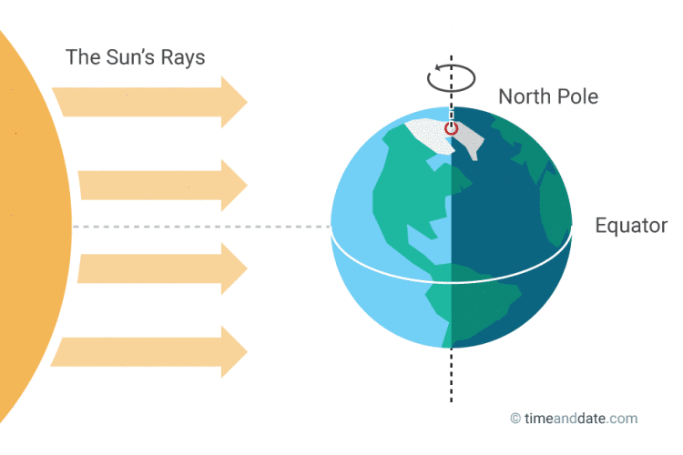
**NOTE** Sunrise/sunset times getting closer to 12hours apart. We are nearing the Vernal Equinox, which occurs this Friday, March 20th at 5:45pm CDT when the sun's most direct rays shine over the Equator.
================
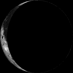
Moon Phase for March 15th at Midnight
2.5 Days After Last Quarter
2.5 Days After Last Quarter
==================
Minneapolis Temperature Trend
Looking out through nearly the end of March, Sunday appears to be the warmest day for a while! With that said, continue enjoying your weekend and make the most it. Get outside!!
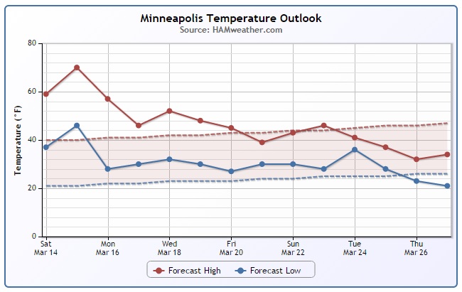
Sunday Weather Outlook
Although Sunday will be quite breezy, you can't ask for much more in mid-March... Temperatures approaching 70F in the Twin Cities is more typical mid-May! The average high of 70F typically occurs on May 17th!
Sunday Weather Outlook
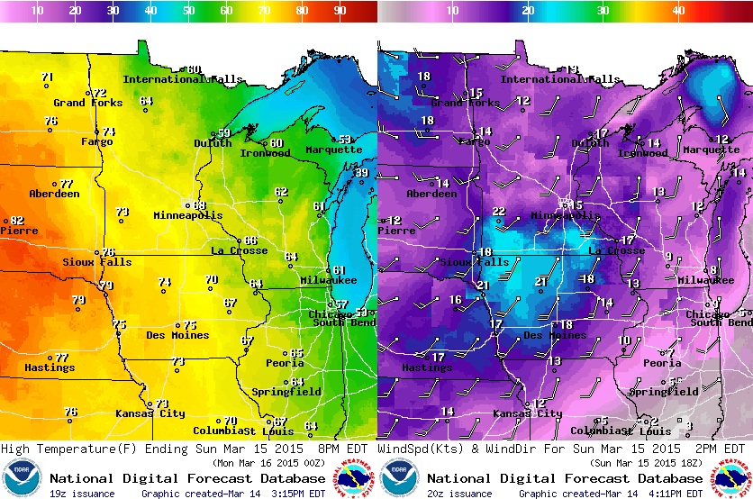
Sunday won't be quiet as sunny as Saturday way, but we will be a little warmer thanks to a stronger southerly breeze. Unfortunately, due to the lack of snow pack, how dry it has been and the warm, breezy weather, fire weather conditions will be ramping up once again across the southern part of the state. The images below show percent sky cover (left) and hazards (right) for Sunday.
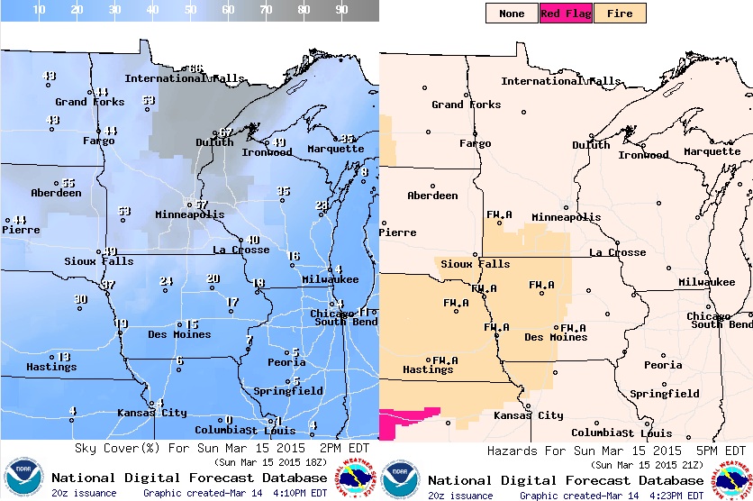
Sunday Fire Weather Concerns
Warm, dry and windy weather on Sunday, areas shaded in red/orange will have the greatest threat for wildfires. Unfortunately, it appears that with the continuation of dry weather, fire weather concerns will continue into the future...
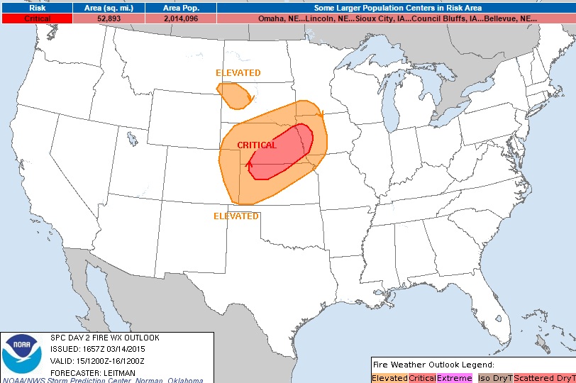
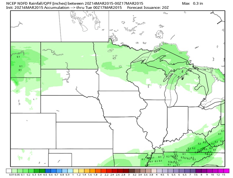
Midwest Precipitation Outlook
The precipitation outlook through PM Monday looks fairly minimal across the Upper Midwest. The best chance for any negligable precipitation looks to be right along the international border on Monday.
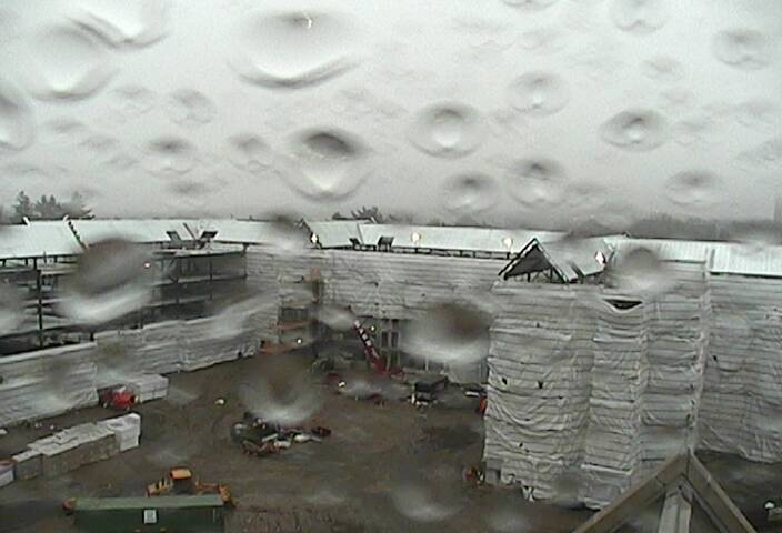
Soggy Saturday in Boston
This was the soggy view from 2150 Commonwealth Ave webcam from Boston College late Saturday afternoon. Note how there are water droplets on the lense and that the precipitation falling was NOT snow! Boston has seen 105.7" of snow this season and need only 2" more to beat the snowiest season in recorded history at 107.6" set in 1995-96. However, there's a little rain/snow in the forecast Sunday/Sunday night, though only minimal snow accumulations are expected.
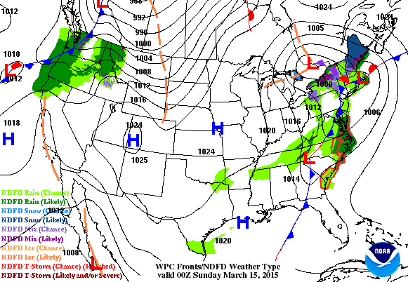
National Weather Outlook
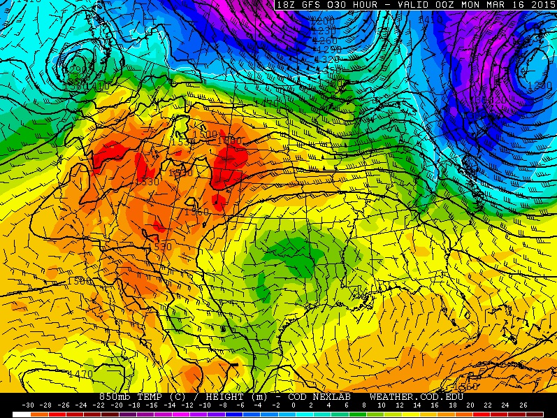
The storm system that brought wet weather to Boston Saturday will exit the Northeast with lingering/plowable snow across the northern New England States on Sunday. Meanwhile, an impulse of energy in place over the Pacific Northwest on Sunday will push east through the day and bring the Midwest a slight precip chance through early week. The main thing you'll notice is the cooler, breezier weather Monday/Tuesday. We'll go from highs running nearly 30F above average to highs running only 10F above average... oh the humanity!
 +
+
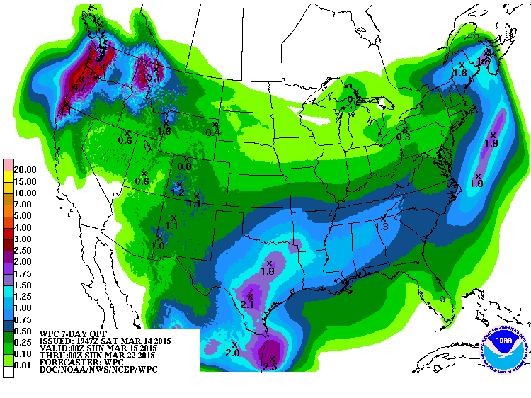
Precipitation Outlook
The rich get richer... unfortunately, the weather pattern seems to be stuck in a groove with the precipitation potential staying in the areas that have been getting most of the precipitation as of late. According to NOAA's HPC, the 7 day precipitation outlook suggets heavier precipitation in the Pacific Northwest, South-Central U.S. and into the Northeast, while the Southwest and Midwest remain mostly dry...
Sunday Temperature Outlook
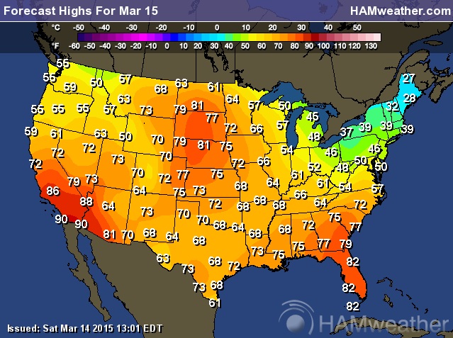
The last several days have been pretty mild across much of the nation. A nice break from the cold weather most of us endured over the winter season. Temperatures on Sunday still look mild for most, but the warmest weather will be across the Southwestern part of the country.
Highs Sunday
What March? Highs Sunday look to reach the 80s and 90s across southern California/Nevada/Arizona, while temperatures in the Plains could reach the 70s and 80s!
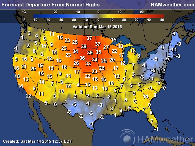
Highs From Average Sunday
Highs across much of the nation (except in Texas/Northeast) will be running above average. Note the well above average levels in the Midwest/Southwest. It'll feel more like mid-May in the areas rather than mid-March!
Cooler By Spring (Friday = Vernal Equinox or First Day of Spring for Northern Hemisphere)
By the end of next week, the mild dream will be over. Temperatures come crashing back down to average/slightly below across the eastern half of the nation. However, the western third of the country looks to stay mild, but not quite as warm as it is now.

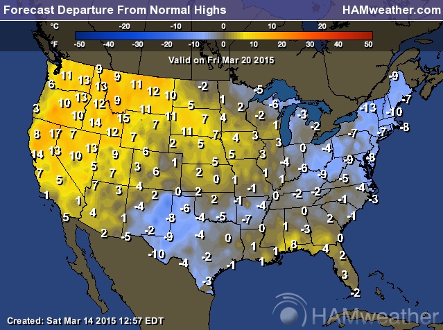
Highs on Friday
While temperatures in the western U.S. and across the southern tier of the nation will still be mild, temperatures across the far north/eastern U.S. will be back to near normal mid-March levels. Now that most of us have been teased by mid-May weather, it may be a little harder to get back to reality...

Friday Highs From Average
Highs on Friday will still be above average across the western U.S., but east of the Rockies temperatures willl be a little closer to average for this time of the year. However, those in the Northeast will still be nearly 10F to 15F below average...
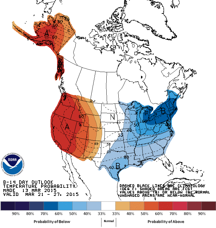
Extended Temperature Outlook
According to NOAA's CPC, the extended temperature outlook from March 21st - 27th keeps the nation divided like it was for much of February. Colder than average in the eastern half/third of the country, while those in the western U.S. and Alaska stay MUCH warmer than average.
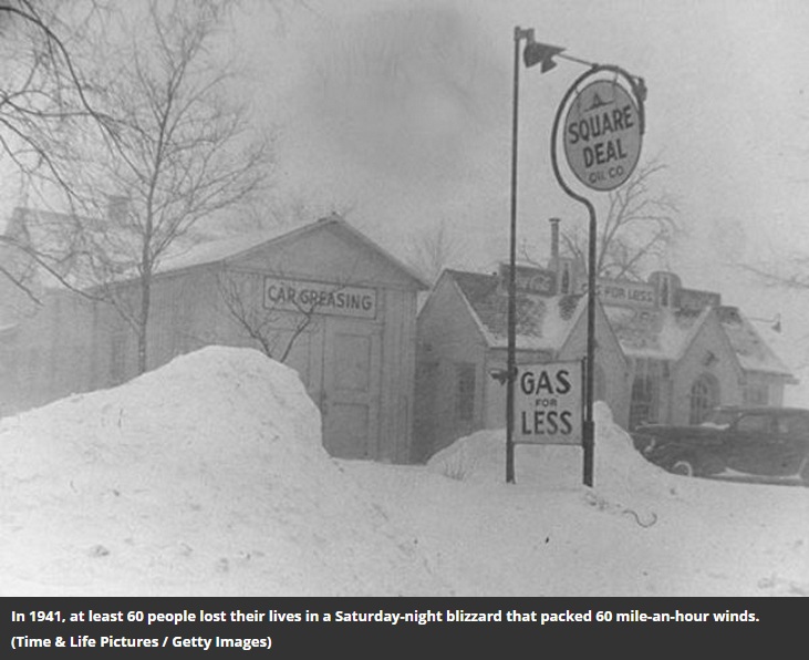
Beware the Ides of March...
Here's an interesting link from Simothsonianmag.com, which ranks the "Deadly Blizzard on the Great Plains, 1941" as one of the top 10 reasons to "Beware the Ides of March"
6. A Deadly Blizzard on the Great Plains, 1941
A Saturday-night blizzard strikes the northern Great Plains, leaving at least 60 people dead in North Dakota and Minnesota and six more in Manitoba and Saskatchewan. A light evening snow did not deter people from going out—“after all, Saturday night was the time for socializing,” Diane Boit of Hendrum, Minnesota, would recall—but “suddenly the wind switched, and a rumbling sound could be heard as 60 mile-an-hour winds swept down out of the north.”
A Saturday-night blizzard strikes the northern Great Plains, leaving at least 60 people dead in North Dakota and Minnesota and six more in Manitoba and Saskatchewan. A light evening snow did not deter people from going out—“after all, Saturday night was the time for socializing,” Diane Boit of Hendrum, Minnesota, would recall—but “suddenly the wind switched, and a rumbling sound could be heard as 60 mile-an-hour winds swept down out of the north.”
(Image courtesy: Time & Life Pictures / Getty Images via Smithsonianmag.com)
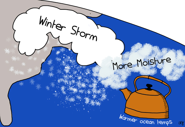
Are record snowstorms proof that global warming isn’t happening?
Here's an interesting read from Climate.gov about snowstorms and climate:
"No. Snowstorms require two things: moisture and freezing air temperatures. There are plenty of places where winter temperatures would have to rise by 10, 20, even 30 degrees Fahrenheit before it would stop snowing. Until then, snowstorms remain quite possible, and natural climate patterns and random variability will still lead to winters that are unusually cold and snowy in different locations.
One way to demonstrate that record snowstorms aren’t incompatible with a warmer climate is to look back at the historical record snowstorms and the seasonal conditions that spawned them. An analysis of such storms between 1961-2010 showed that while most extreme snow storms did occur in seasons that were colder and wetter than average, about 35 percent of snow seasons that produced extreme snow events were warmer than average, and 30 percent were drier than average.
Scientists have measured a significant increase in water vapor in the surface atmosphere over land and ocean relative to the 1970s. This global increase is consistent with the long-term warming trend in our planet's average surface temperature. Warmer air temperatures fuel more evaporation, leading to a wetter atmosphere, which increases rain or snow totals."
Thanks for checking in and have a great rest of your weekend! Don't forget to follow me on Twitter @TNelsonWX

No comments:
Post a Comment