The 1965 Fridley tornado outbreak has been called the greatest weather disaster in Twin Cities history and was deemed the 5th (tied) most significant Minnesota weather event of the 20th century by members of Minnesota's climate community.
"Fifty years ago on Thursday, May 6, 1965 the worst tornadoes in Twin Cities history struck the western and northern metro area. There were five tornadoes in the metro area, with another tornado just to the west in Sibley and McLeod Counties. The first tornado to touch down was at 6:08pm in Carver County and the final tornado lifted off at 9:02pm in southern Anoka County. Four of the tornadoes were rated F4 on the Fujita Scale, one was an F3 and another was an F2. There hasn't been a day since in Minnesota when there were four F4 tornadoes in a single day."
"Thirteen people were killed and 683 were injured. There was one death in Sibley County, three deaths in both Carver and Anoka County, and six in Hennepin County. Some of the places that were hardest hit were Chanhassen, Deephaven, Fridley, Mounds View and Spring Lake Park. Rural Sibley and Carver County was also hard hit."
Read more from the MN DNR Climate Journal HERE:
(Image courtesy Star Tribune: Headline of Minneapolis Tribune day after May 6, 1965 Tornadoes. The tornado photo was taken at 8:30pm and was illuminated by lightning.)

_________________________________________________________
1965 Fridley Tornadoes
By Todd Nelson
It has been called the "Greatest weather disaster in Twin Cities history" and was deemed the "5th most significant Minnesota weather event of the 20th century" by members of the Minnesota's climate community.
50 years ago Thursday, May 6th, nearly a dozen people died and nearly 700 were injured when 6 twisters touched down in Minnesota from 6pm to 9pm. 4 of the 6 tornadoes were rated F4s with wind speeds to near 200mph! While we haven't anything like it since, it is a good reminder that tornadoes CAN hit big cities! I hate to think of it, but if that type of event were to unfold today, damage would be much worse.
We stay tornado-free, but a few thunderstorms and heavy downpours will move through the region over the next couple of days. As of Tuesday, Minneapolis was nearly 3 inches below average precipitation since January 1st. A few locations across northwestern Minnesota may need 5 to 7 inches of rain to pull out of the severe drought that has developed there.
Forecasts are still suggesting nearly 1 inch of much needed rain through the weekend. A few more good soaks and we'll be pulling out of the drought and swatting skeeters. Get the deet!
_________________________________________________________
TUESDAY NIGHT: Clouds thicken, chance of spotty showers and storms. Low: 55. Winds: ESE 10-15.
WEDNESDAY: Breezy. Rain with spotty thunder. High: 73. Winds: SE 15-25.
WEDNESDAY NIGHT: Cloudy. Chance of showers and storms. Low: 62. Winds: SSE 10-15.
THURSDAY: Scattered showers and storms. Heavy PM downpours possible. High: 76. Winds: SSE 15-25
FRIDAY: Cooler. Drier northwest breeze. Wake-up: 54. High: 65.
SATURDAY: Dry for the fishing opener. Wake-up: 48. High: 64.
SUNDAY:Breezy Mother's Day. Rain develops late across southern MN. Wake-up: 48. High: 61.
MONDAY: Rain and thunder possible across southern MN. Wake-up: 47. High: 60.
TUESDAY: Cooler. Lingering showers. Wake-up: 43. High: 59.
__________________________________________________________
This Day in Weather History
May 6th
1965: A family of 6 tornadoes hit an 11 county area, including the western Twin Cities. 14 people were killed, 683 were injured. 3 of the tornadoes hit Fridley.
__________________________________________________________
Average High/Low for Minneapolis
May 6th
Average High: 67F (Record: 89F set in 1934)
Average Low: 46F (Record: 25F set in 1989)
__________________________________________________________
Sunrise/Sunset Times for Minneapolis
May 6th
Sunrise: 5:56am
Sunset: 8:23pm
__________________________________________________________
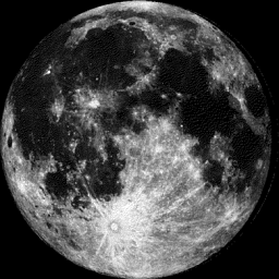
Moon Phase for May 6th at Midnight
4.2 Days Before Last Quarter
___________________________________________________________
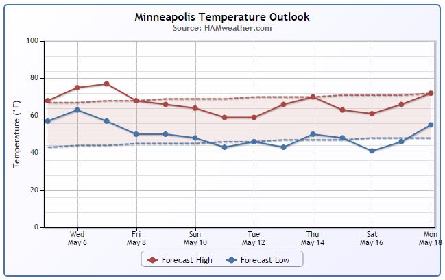
Minneapolis Temperature Trend
It certainly hasn't been a bad start to May. In fact, we've been dealing with more June-like temperatures and it appears that we'll continue our mild ways through much of the rest of the week. Through May 4th, Minneapolis' average temperature was 63.5° (+8.5° above average)! Cooler temperatures (near average) look to move in by the weekend with some of the coolest readings in place by early next week.
__________________________________________________________
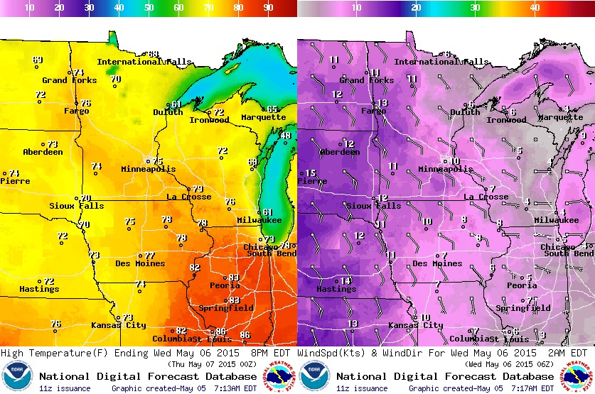
Wednesday Weather Outlook
Wednesday will still be a mild day across the region with highs warming into the 70s (nearly 10° above average), but it'll feel a little cooler with more clouds and scattered showers.
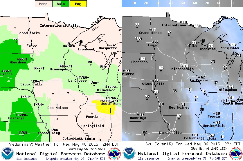
Weather Weather Outlook
Wednesday won't be a washout, but there will be areas of scattered showers and storms. Note the cloud cover (image on right) looks fairly cloudy for much of the state.
Simulated Radar
Wednesday and Thursday will be more unsettled than what the week started with. Scattered showers and storms look to continue pushing through the region through PM Thursday before we clear out of Friday. The good news is that the severe threat remains low, but much needed precipitation chances remain elevated.

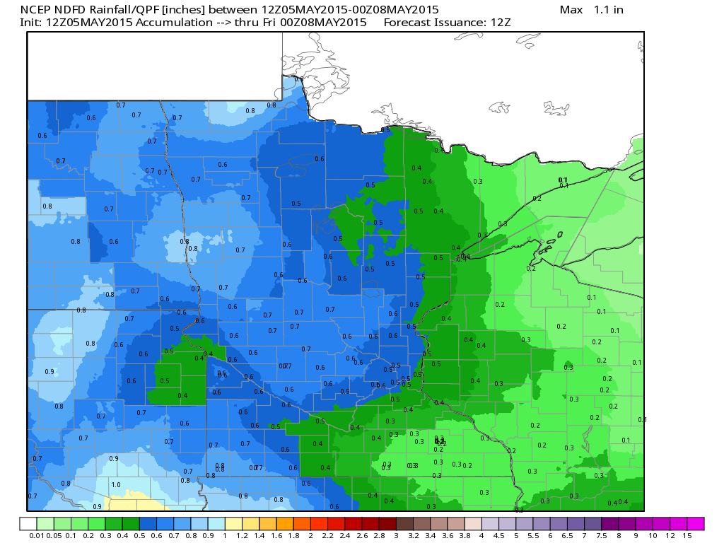
Rainfall Through PM Thursday
The forecast suggests up to 0.50" or more of much needed rainfall across the central and western Minnesota through PM Thursday. Keep in mind that many locations across the state are nearly 2" to 3" below average precipitation since January 1st.
________________________________________________________
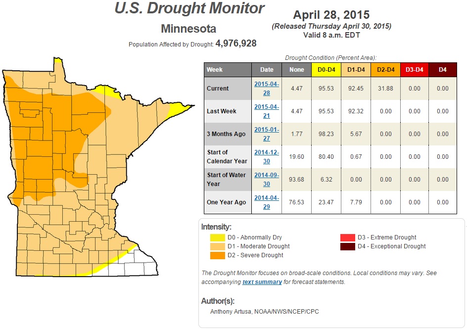
Minnesota Drought Conditions
According to the U.S. Drought Monitor, nearly 93% of the state is considered to be in an moderate drought, while nearly 32% of the state is now in a severe drought. This is up from the 0% severe drought a couple of weeks ago. The newest U.S. Drought Monitor will be released Thursday.
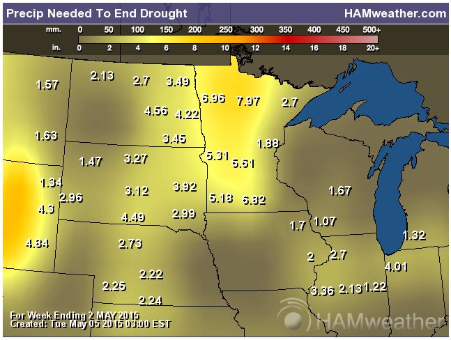
Rain Needed to End Drought
Here's an interesting graphic that quantifies how much precipitation we would need to end the drought. Note that some locations across western Minnesota would need nearly 5" to 7" of rain or more!
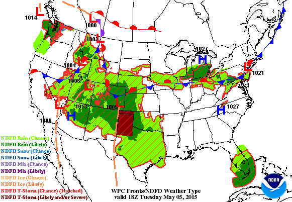
National Weather Outlook
The national weather outlook through AM Thursday remains busy across much of the Central U.S. as our current storm system continues lifting northeast towards the Upper Midwest. Areas of scattered showers and strong to severe storms will continue to move through the middle part of the country until then. Note that some of the higher elevations across the Western U.S. may be in for a little snow through the middle/end of the week as well! Also note the area of low pressure developing east of Florida. This particular storm system has captured the attention of the National Hurricane Center!
____________________________________________________
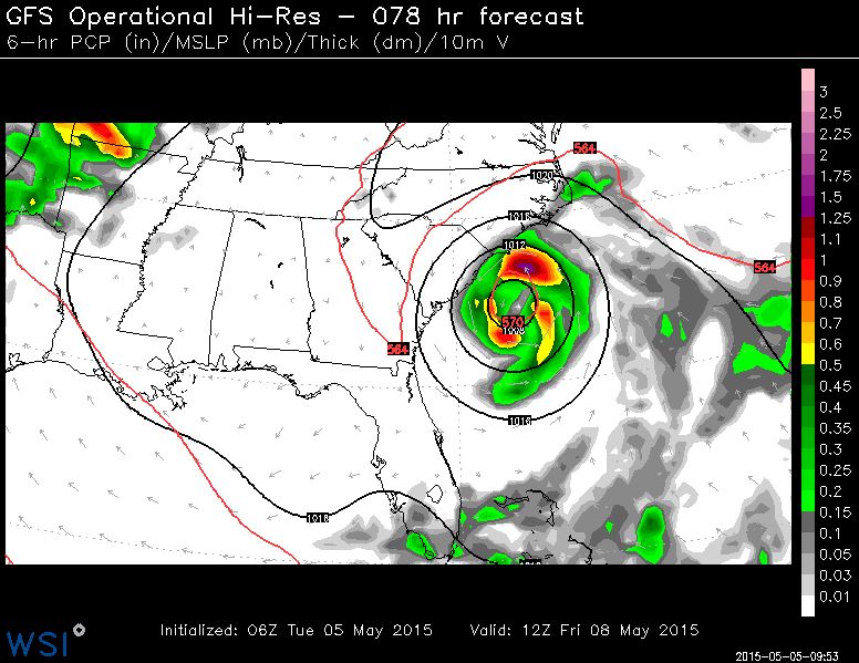
Sub-Tropical Characteristics?
The forecast by AM Friday shows a fairly robust area of low pressure just east of South Carolina. It's an interesting area of low pressure that may gain tropical characteristics by the end of the week. Keep in mind that this is a little earlier than normal. Nearly 97% of all tropical activity in the Atlantic Basin occurs from June 1st - November 30th.
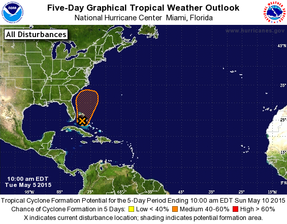
Tropical Weather Outlook
For the North Atlantic...Caribbean Sea and the Gulf of Mexico:
1. A large area of disorganized showers and thunderstorms extending from the northwestern Caribbean Sea across Cuba, southern Florida, and the Bahamas is associated with an upper-level trough and a weak surface trough. An area of low pressure is expected to form in association with this disturbance during the next day or two. The low could gradually acquire subtropical characteristics over the next few days while it moves generally northward at a slow forward speed. For additional information on this system, see High Seas Forecasts issued by the National Weather Service.
The next Special Tropical Weather Outlook will be issued on this system by 11 AM EDT Wednesday.
* Formation chance through 48 hours...low...20 percent
* Formation chance through 5 days...medium...40 percent
See more from the National Hurricane Center HERE:
2015 Atlantic Cyclone Names
It'll be interesting to see whether or not our area of low pressure mentioned above intensifies enough to become named, but if it does, it would be named Ana (AH-nah). Here's the list of 2015 Atlantic Hurricane names.

_____________________________________________________________
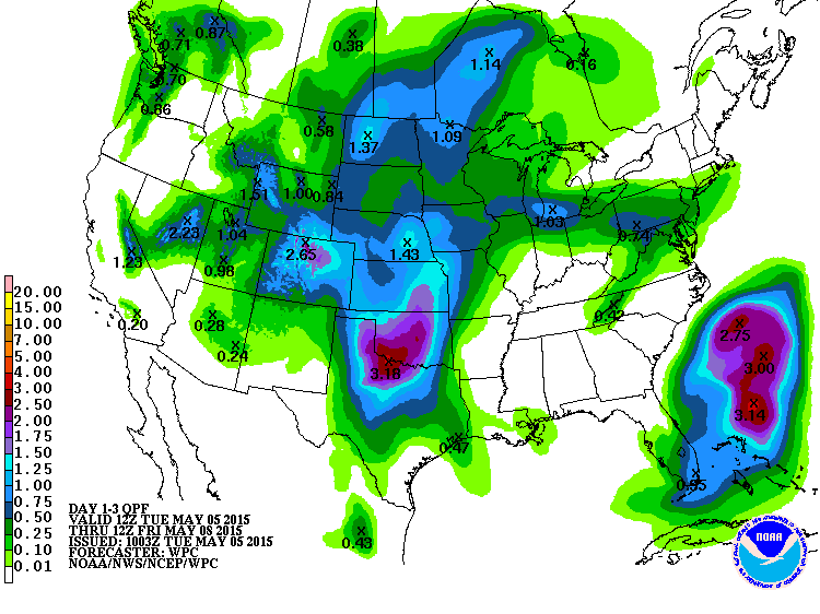
3 Day Precipitation Outlook
According to NOAA's HPC, the 3 day precipitation forecast, areas of showers and storms across parts of the Central U.S. will be responsible for nearly 1" to 3" of rainfall potential through AM Friday.
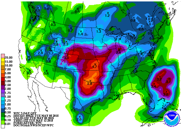
7 Day Precipitation Outlook
When it rains, it pours! Another area of low pressure will move into some of the same areas seeing showers and storms now. This next area of low pressure will start producing more rounds of heavy rain/thunder late this week and into the weekend. According to NOAA's HPC, the 7 day precipitation forecast suggests 3" to 5" or more rainfall potential through early next week.
________________________________________________
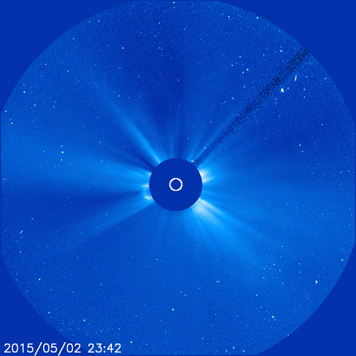
Northern Lights Potential?
"A filament of magnetism straddling the sun's southern hemisphere erupted on May 2nd and hurled a CME into space. Modeling by NOAA analysts suggests that the CME will reach Earth on May 6th. Forecasters estimate a 45% chance of geomagnetic storms when the CME arrives. Bright moonlight and summer twilight will probably overwhelm any auroras around the Arctic Circle. The Antarctic Circle is much darker. Stay tuned for SouthernLights."
See more from SpaceWeather.com HERE:
This is a pretty good site to bookmark regarding northern lights forecasts/potential.
See more from SoftServeNews.com
_____________________________________________________________
Thanks for checking in and have a great rest of your week! Don't forget to follow me on Twitter @TNelsonWX

No comments:
Post a Comment