
Early Start?
By Todd Nelson
I spent lots of time at my grandparents house as a kid and I remember my grandma always being the first one out of bed in the morning. Hearing her shuffle a deck of cards, I would stumble to the kitchen and watch her play solitaire until the sun came up. When I asked her why she got up so early, she would tell me that the "Early bird gets the worm." I think because of her, I am an early riser and I am happy to report grandma, that I've got worms! Lots of them! Not by choice, but because my alarm goes off at 2am! UGH!
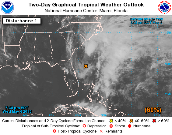
Sure it's nice to be early, but what about the tropics? An area of low pressure with some sub-tropical characteristics east of Florida, has caught the attention of the National Hurricane Center! On average, 97 percent of all tropical systems in the Atlantic Basin develop from June 1 to November 30. While not unprecedented, it is a bit early.
On the other hand, even though May temps are running nearly 9 degrees above average, ice out dates and blooming flowers are happening right around the climatological norm for us. We'll see some Spring thundershowers Thursday, then drier weather for the fishing opener Saturday. Mom's day looks windy and wet late.
___________________________________________
WEDNESDAY NIGHT: Cloudy. Chance of showers and storms. Low: 62. Winds: SSE 10-15.
THURSDAY: Scattered showers and storms. Locally heavy downpours possible. High: 76. Winds: S 10-20
THURSDAY NIGHT: Spotty showers and storms. Low: 54. Winds: SSW 10-15.
FRIDAY: Soggy start. Cooler with lingering showers early. High: 64. Winds: NW 10-15
SATURDAY: Looking dry for the fishing opener. Wake-up: 49. High: 65.
SUNDAY:Breezy Mother's Day. Rain develops late across southern MN. Wake-up: 48. High: 61.
MONDAY: More wind. Chilly rain/thunder across far southern Minnesota. Wake-up: 45. High: 58.
TUESDAY: Slow clearing. Not as breezy. Wake-up: 42. High: 60.
WEDNESDAY: Sun returns. Back to near average temps. Wake-up: 45. High: 67.
___________________________________________
This Day in Weather History
May 7th
1916: Strong winds sweep across the state and cause sandstorms over southern Minnesota. Great damage was done to standing timber in Northern Minnesota. In Duluth, a boy in trying to cross St. Louis Bay was drowned by the waves capsizing his boat. Many fires were started, one of which destroyed 30,000,000 feet of lumber.
1915: Old man winter's last hurrah with 5 inches of snow along Lake Superior.
____________________________________________
Average High/Low for Minneapolis
May 7th
Average High: 67F (Record: 92F set in 1963)
Average Low: 46F (Record: 27F set in 1885)
____________________________________________
Sunrise/Sunset Times for Minneapolis
May 7th
Sunrise: 5:54am
Sunset: 8:25pm
_____________________________________________
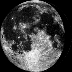
Moon Phase for May 7th at Midnight
3.2 Day Before Last Quarter
__________________________________________
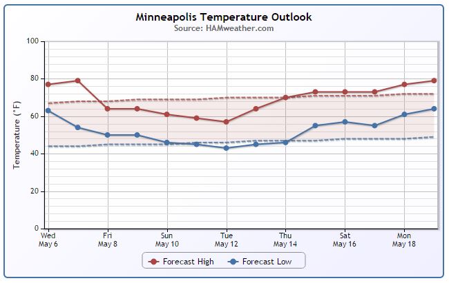
Minneapolis Temperature Trend
Mild weather continues yet through Thursday, but a departing storm system pulls down some cooler temperatures for the end of the week and for much of next week. Temperatures will be running a few degrees below average for several days before we warm again to near normal levels mid May!
____________________________________
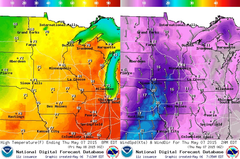
Thursday Temperature Outlook
Despite our scattered shower and thunderstorm potential across the region, temperatures will still be running above average. High in the Twin Cities will approach the mid 70s with breezy southeast winds.
Thursday Weather Outlook
Thursday could be our wettest day of the week as the storm system lifts northeast through the region. Spotty thundershowers could help to promote heavy downpours at times. Keep in mind that Minneapolis is still nearly 3" below average precipitation since January 1st, so this moisture is much needed!

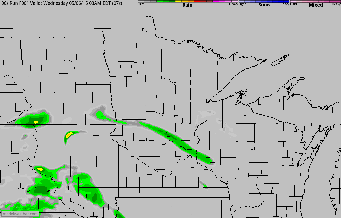
Simulated Radar
The simulated radar through early AM Friday shows swarms of showers and isolated thundershowers pushing through the region. While storms will likely stay below severe limits, a few locally heavy downpours can't be ruled out.
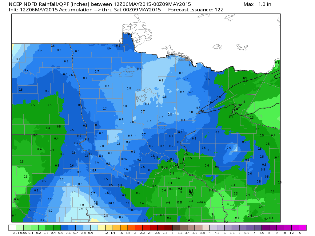
Rainfall Potential Through Friday
Forecasts continue to suggest the potential of nearly 0.50" to 1" rainfall amounts across parts of western and northern Minnesota through PM Friday. We look to dry out PM Friday through Saturday before more rain pushes through the region late weekend into early next week.
___________________________________________________
National Weather Outlook
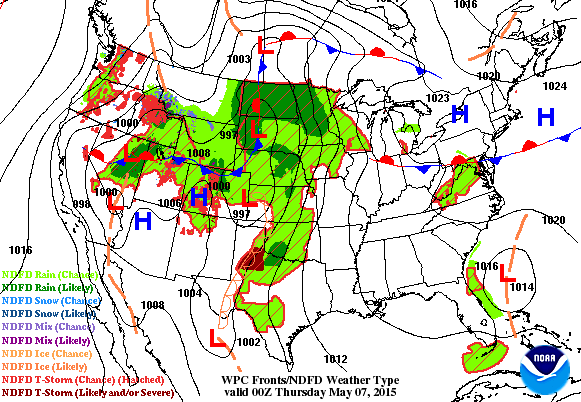
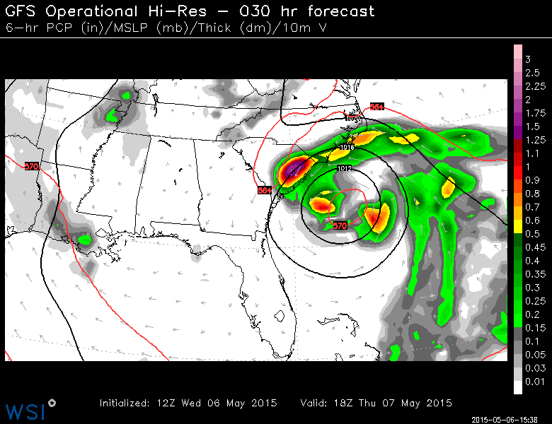
Our slow moving storm system continues to gradually lift northeast through the Upper Midwest through the end of the week. The heaviest precipitation over the next few days will be across the Central and Southern Plains with heavier thunderstorm activity. Note the area of low pressure developing near the Carolina Coast! That low pressure system has some sub-tropical characteristics and has caught the attention of the National Hurricane Center.
Tropical System?
The forecast by midday Thursday shows a fairly robust area of low pressure just off the Carolina Coast. Gusty winds and locally heavy rainfall will be associated with the storm system, but widespread stronger rip current potential will be found along the beaches from the Carolinas to Florida.
Tropical System?
For the North Atlantic...Caribbean Sea and the Gulf of Mexico:
1. Disorganized showers and thunderstorms extending northward from the Bahamas to just offshore of the coast of the Carolinas are associated with an upper-level trough and a weak surface low located a couple of hundred miles east of the northeast Florida coast. Conditions are expected to become gradually more favorable for development over the next day or so while this system moves slowly northward and then northwestward. A subtropical or tropical cyclone could form by tomorrow or Friday, and interests along the southeast coast of the United States should monitor the progress of this system. Regardless of development, heavy rain is possible over portions of the coastal southeastern United States beginning tomorrow.
For additional information, see products from your local National Weather Service forecast
office and High Seas Forecasts issued by the National Weather
Service.
* Formation chance through 48 hours...medium...60 percent
* Formation chance through 5 days...medium...60 percent
______________________________________________________________
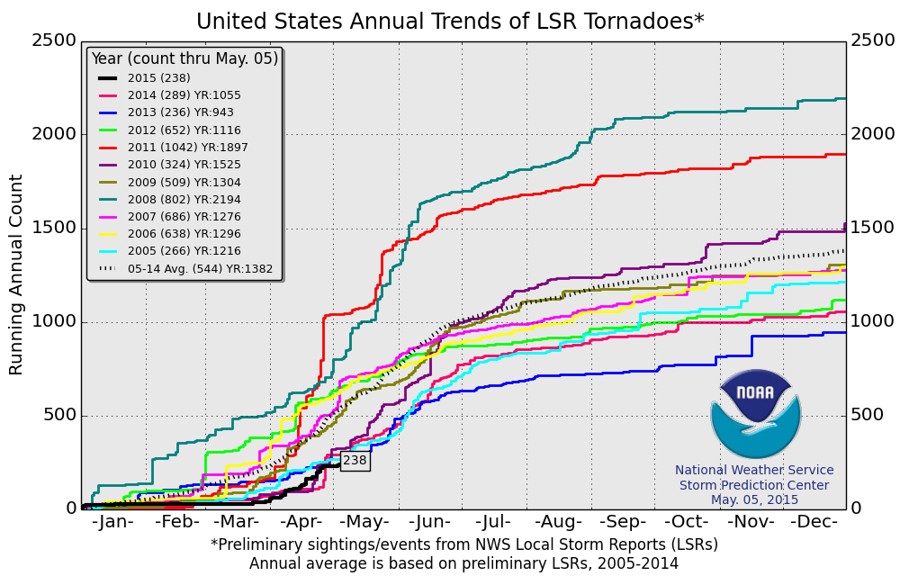
Lack of Severe Weather in 2015?
According
to NOAA's Storm Prediction Center, the 2015 PRELIMINARY tornado count
through May 5th is 238. The 2005-2014 average is 544, so we are nearly
300 below the short-term average! During the specified years, the only
other year that had fewer tornado reports than 2015 was in 2013 when
there were only 236 reports through May 5th.
Severe Threat Wednesday
...SUMMARY...SEVERE THUNDERSTORMS WILL BE POSSIBLE THURSDAY FROM PORTIONS OF THE
SOUTHERN AND CENTRAL PLAINS NORTHEASTWARD INTO THE UPPER MIDWEST.
...SYNOPSIS...
RELATIVELY LIMITED LARGE-SCALE PATTERN FLUCTUATION WILL OCCUR OVER
THE CONUS ON THURSDAY. AN INCREASINGLY CLOSED UPPER LOW OVER THE
PACIFIC NORTHWEST WILL SHIFT SOUTH-SOUTHWESTWARD OVER THE GREAT
BASIN/CA ON THURSDAY...WHILE ONE OR MORE SHORTWAVE
TROUGHS/CONVECTIVELY RELATED DISTURBANCES MOVE NORTHEASTWARD OVER
THE CENTRAL/SOUTHERN PLAINS TO UPPER MIDWEST AMID A MODERATELY
STRONG BRANCH OF SOUTHWESTERLY FLOW ALOFT. A COLD FRONT WILL SPREAD
EASTWARD OVER THE UPPER MIDWEST/MIDDLE MO VALLEY THROUGH THURSDAY
NIGHT...WHILE A DRYLINE WILL EXTEND GENERALLY SOUTHWARD ACROSS WEST
TX/FAR WESTERN OK FROM A SOUTH-CENTRAL HIGH PLAINS SURFACE LOW.
...CENTRAL/SOUTHERN PLAINS...
MORNING SHOWERS/SOME EMBEDDED THUNDERSTORMS AND RELATED CLOUD COVER
WILL LIKELY BE FACTORS THURSDAY MORNING ACROSS PORTIONS OF KS/OK
INTO NORTH TX. ON THE WESTERN FRINGE OF THIS EARLY DAY ACTIVITY...AN
ELEVATED MIXED LAYER/PLUME OF STEEP MID-LEVEL LAPSE RATES WILL
QUICKLY BECOME REESTABLISHED ATOP A RELATIVELY MOIST AIR MASS WITH
60S F SURFACE DEWPOINTS COMMON TO THE EAST OF A SOUTHERN HIGH PLAINS
DRYLINE/SURFACE TRIPLE POINT AND TO THE SOUTHEAST OF A SLOW
SOUTHEASTWARD-MOVING FRONT ACROSS NORTHERN KS/EASTERN NEB. SCENARIO
SHOULD LEAD TO AT LEAST MODERATE DESTABILIZATION WITH UPWARDS OF
2500-3500 J/KG MLCAPE PLAUSIBLE BY MID-AFTERNOON PARTICULARLY ACROSS
WEST-CENTRAL/NORTH-CENTRAL TX INTO EASTERN TX PANHANDLE/WESTERN OK
AND WESTERN/NORTHERN KS.
LARGER-SCALE FORCING FOR ASCENT WILL BE RELATIVELY MODEST...BUT THE
LEFT-EXIT REGION OF AN APPROACHING SOUTHERN STREAM JET AND THE
INFLUENCE OF MODERATELY STRONG CYCLONIC WESTERLIES...ALONG WITH
STRONG HEATING/SUFFICIENT CONVERGENCE...SHOULD CONTRIBUTE TO AT
LEAST ISOLATED DEEP CONVECTIVE INITIATION BY MID/LATE AFTERNOON.
INITIAL DEEPER CONVECTIVE DEVELOPMENT MAY OCCUR ACROSS EASTERN CO BY
MID/LATE AFTERNOON VIA A POST-FRONTAL UPSLOPE REGIME...WITH
ADDITIONAL DEVELOPMENT BY LATE AFTERNOON/EARLY EVENING NEAR THE
DRYLINE ACROSS THE TX/OX PANHANDLES AND NEAR THE TRIPLE
POINT/ADJACENT FRONT ACROSS WESTERN/NORTHERN KS.
GIVEN AFOREMENTIONED BUOYANCY...DEEP-LAYER SHEAR /GENERALLY 35-40
KT/ WILL BE SUPPORTIVE OF SUPERCELLS CAPABLE OF LARGE HAIL ALONG
WITH SOME TORNADO RISK. CURRENT THINKING IS THAT THE RELATIVELY
GREATEST TORNADO POTENTIAL WILL EXIST BY EARLY EVENING ACROSS PARTS
OF NORTHWEST TX/FAR WESTERN OK NEAR THE DRYLINE...WITH RESIDUAL
OUTFLOW/DIFFERENTIAL HEATING POTENTIALLY AN ADDITIONAL MESOSCALE
FACTOR ASIDE FROM A NOCTURNALLY STRENGTHENING LOW-LEVEL JET. STORMS
SHOULD COALESCE INTO ONE OR MORE EASTWARD-SPREADING MCS/S DURING THE
LATE EVENING/OVERNIGHT HOURS ACROSS OK/KS AS THE LOW-LEVEL JET/WARM
ADVECTION FURTHER INCREASES.
...SOUTHERN MN AND IA/NORTHWEST MO...
A NORTHEASTWARD-MOVING SHORTWAVE TROUGH WILL AT LEAST GLANCE MOST OF
THE REGION...WHILE WIDESPREAD EARLY-DAY CLOUD COVER/SCATTERED
PRECIPITATION WILL LIKELY PRECEDE AN EAST-SOUTHEASTWARD MOVING COLD
FRONT. DEEP-LAYER SHEAR WILL BE MODEST /30-35 KT AT MOST/ AND
UNCERTAINTIES EXIST REGARDING THE RESIDUAL IMPACTS OF EARLY DAY
CLOUDS/PRECIPITATION. HOWEVER...AT LEAST MODEST CLOUD BREAKS/HEATING
AND THE INFLUX OF LOWER 60S F SURFACE DEWPOINTS COULD LEAD TO
MODERATE DESTABILIZATION THROUGH THE AFTERNOON/EARLY EVENING. THIS
MAY LEAD TO AT LEAST AN ISOLATED SEVERE HAIL/WIND RISK AS STORMS
LIKELY REDEVELOP/INTENSIFY NEAR OR EAST OF THE COLD FRONT. PORTIONS
OF THE REGION COULD WARRANT A CATEGORICAL RISK UPGRADE /SLIGHT/ IN
SUBSEQUENT DAY 1 OUTLOOKS.
...NORTHERN/CENTRAL PORTIONS OF NV/UT...
A FEW STRONGER STORMS WILL BE POSSIBLE OVER THE REGION IN
ASSOCIATION WITH THE EXIT REGION OF THE
RETROGRADING/SOUTHWESTWARD-MOVING UPPER LOW OVER THE WESTERN GREAT
BASIN/CENTRAL CA. STEEP LAPSE RATES/MODEST BUOYANCY AND A SUFFICIENT
VERTICAL SHEAR COULD ALLOW FOR LOCALLY STRONGER WINDS AND POSSIBLY
SOME HAIL.
...COASTAL CAROLINAS THURSDAY NIGHT...
WHILE NOT HIGHLY CONFIDENT IN THE DETAILS...A STRENGTHENING
LOW-LEVEL WIND FIELD COULD APPROACH THE COASTAL CAROLINAS AS EARLY
AS THURSDAY NIGHT/EARLY FRIDAY IN ASSOCIATION WITH A POSSIBLE
SUBTROPICAL OR TROPICAL CYCLONE. REFERENCE THE SPECIAL TROPICAL
WEATHER OUTLOOK STATEMENT FROM NHC FOR ADDITIONAL DETAILS. ANY LOW
TORNADO RISK APPEARS TOO SPECULATIVE DURING THE DAY 2 TIME FRAME
WITH CURRENT THINKING BEING THAT ANY MINI-SUPERCELLS WILL BE WELL
OFFSHORE.
Severe Threat Friday
...SUMMARY...
SEVERE THUNDERSTORMS WILL BE POSSIBLE FRIDAY ACROSS PORTIONS OF THE
CENTRAL AND SOUTHERN PLAINS NORTHEAST INTO SOUTHWEST ILLINOIS.
...SYNOPSIS... AN UPPER LOW OVER SRN CA WILL MOVE EWD TO CENTRAL AZ
DURING FRIDAY AS A BELT OF SWLY FLOW ALOFT PREVAILS FROM THE SRN/CENTRAL
PLAINS INTO THE GREAT LAKES. A FRONTAL BOUNDARY WILL EXTEND FROM THE
MICHIGAN UPPER PENINSULA SWWD TO THE NRN TX PANHANDLE LATE FRIDAY AFTN
WITH A DRYLINE EXTENDING SWD THROUGH THE TX PANHANDLE/W TX. A SFC LOW
SOUTH OF THE NORTH CAROLINA COAST WILL MOVE NWD. CONSULT THE LATEST
INFORMATION FROM THE NATIONAL HURRICANE CENTER. ...SRN/CENTRAL PLAINS...
A CONVECTIVE COMPLEX MAY BE ONGOING FRIDAY MORNING ACROSS PORTIONS OF
KS/OK AIDED BY WAA ASSOCIATED WITH A SWLY LOW-LEVEL JET. RESIDUAL
OUTFLOW/CLOUDS WILL INFLUENCE THE EFFECTIVE FRONTAL POSITION AND
SUBSEQUENT PREFERRED LOCATIONS FOR NEW TSTM DEVELOPMENT. HEIGHT
FALLS/LARGE-SCALE FORCING FOR ASCENT ASSOCIATED WITH THE EWD-MOVING
UPPER LOW WILL REMAIN W OF THE CENTRAL/SRN PLAINS FRIDAY...HOWEVER
LOW-AMPLITUDE IMPULSES WITHIN THE SWLY FLOW WILL ONCE AGAIN INFLUENCE
AFTN/EVENING CONVECTIVE TRENDS. ONE IMPULSE TRAVERSING THE CENTRAL
PLAINS EARLY FRIDAY MAY AID THE CONTINUATION OF MORNING TSTMS THROUGH
THE AFTN ACROSS PORTIONS OF MO/IL. THE FOCUS FOR MORE CONSEQUENTIAL TSTM
DEVELOPMENT FRI AFTN WILL BE ALONG THE FRONTAL BOUNDARY AND SWD ALONG
THE DRYLINE OVER SRN KS/OK/W TX. STG SFC-BASED BUOYANCY...40-50 KTS OF
DEEP-LAYER SHEAR AND STEEP MID-LEVEL LAPSE RATES WILL INITIALLY FAVOR
SUPERCELLS WITH LARGE HAIL. RELATIVELY LOW LCL HEIGHTS AND NOCTURNALLY
INCREASING LOW-LEVEL FLOW WILL ALSO RESULT IN A TORNADO THREAT DURING
THE EVENING HOURS BEFORE UPSCALE GROWTH INTO A MESOSCALE CONVECTIVE
COMPLEX OCCURS. DAMAGING WINDS AND LARGE HAIL WILL REMAIN POSSIBLE AS
THE MCS MOVES EWD OVERNIGHT. ...SRN NC COAST... LATEST GUIDANCE PLACES A
SFC LOW ALONG THE COAST NEAR THE NC-SC BORDER DURING THE DAY
FRIDAY...WITH STRONG LOW-LEVEL ELY FLOW RESULTING IN
SUBSTANTIALLY-CURVED LOW-LEVEL HODOGRAPHS. THE RISK FOR A TORNADO WILL
EXIST WITH CONVECTIVE CELLS NEAR/ALONG THE COAST.
Severe Threat Saturday
...DISCUSSION...
THE UPPER LEVEL LOW NEAR THE FOUR CORNERS REGION AT 12Z SAT WILL LIFT
NEWD TOWARDS THE UPPER MIDWEST/GREAT LAKES REGION TUESDAY...INTERACTING
WITH A NRN-STREAM UPPER TROUGH DIGGING SEWD FROM MANITOBA AS IT SHIFTS
INTO THE NERN U.S. BY WED. A WEAKER BELT OF WLY FLOW ALOFT WILL PERSIST
FROM TX ACROSS THE GULF COAST. ...SATURDAY/D4... DESPITE ANOTHER ROUND
OF MORNING TSTMS OVER PORTIONS OF THE CENTRAL/SRN PLAINS EARLY SAT...THE
INGREDIENTS APPEAR TO BE COMING TOGETHER FOR A SUBSTANTIAL SEVERE
WEATHER EVENT ACROSS THE SRN/CENTRAL PLAINS SAT AFTN/EVENING. ALTHOUGH
SOME TIMING/LOCATION DIFFERENCES EXIST AMONGST LATEST GUIDANCE...THERE
IS GENERAL AGREEMENT ON HEIGHT FALLS/DCVA OVERSPREADING A VERY MOIST
WARM SECTOR /SFC DEW POINTS 65 TO NEAR 70/ AHEAD OF A DRYLINE EXTENDING
FROM SWRN KS SWD INTO W TX. 50-60 KTS OF SWLY 500 MB FLOW WILL ROTATE
AROUND THE UPPER LOW AND ACROSS OK/KS AS A SFC LOW TAKES SHAPE OVER SWRN
KS BY EARLY EVENING. SVR TSTMS WILL LIKELY DEVELOP ALONG THE DRYLINE
AND NEAR THE SFC LOW/WARM FRONT DURING THE AFTN IN AN ENVIRONMENT
FAVORABLE FOR SUPERCELLS WITH ALL SEVERE HAZARDS POSSIBLE. STORMS SHOULD
EVENTUALLY EVOLVE INTO CLUSTERS OR LINES WITH A CONTINUED SVR THREAT
OVERNIGHT.

Severe Threat Sunday
...SUNDAY...
AS THE SFC LOW LIFTS NEWD TO NR THE NEB/IA BORDER...SVR TSTMS APPEAR
POSSIBLE ONCE AGAIN IN ADVANCE OF A COLD FRONT EXTENDING SWD FROM THE
LOW INTO ERN OK/N TX...AND NEAR/SOUTH OF A WARM FRONT EXTENDING EWD
ACROSS CENTRAL/NRN IL. A PLUME OF STEEPER MID-LEVEL LAPSE RATES MAY BE
IN PLACE SUPPORTING MODERATE-STRONG BUOYANCY AS HEIGHT FALLS/FORCING FOR
ASCENT SHIFTS EWD ACROSS THE AREA. A MIX OF STORM MODES INCLUDING
SUPERCELLS AND LINES/CLUSTERS APPEARS PROBABLE.
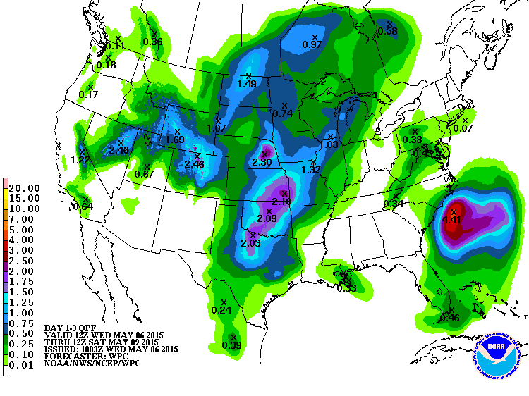
3 Day Precipitation Outlook
The area of low pressure lifting northeast into the Upper Midwest through the end of the week will be responsible for some heavier rainfall tallies across parts of the Central and Southern Plains through the early weekend time frame. While folks in the Upper Midwest aren't expecting as much as areas in the south, this is still welcomed as many areas are dealing with drought there.
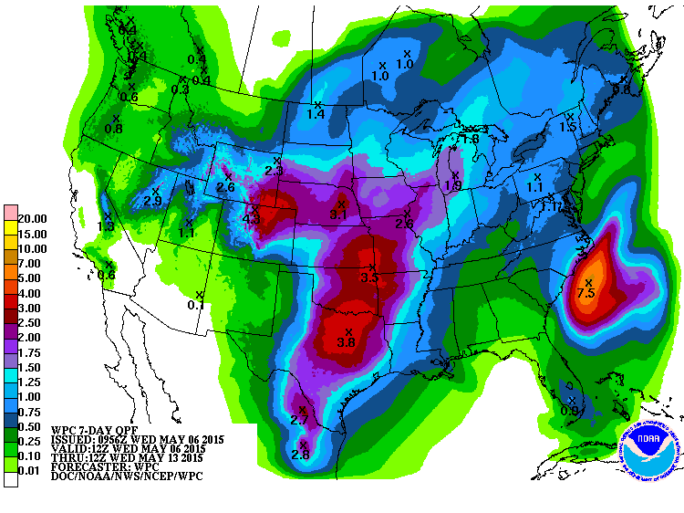
7 Day Precipitation Outlook
When it rains, it pours! Another area of low pressure will develop late week/weekend and bring even more rain and thunder across the Central and Southern Plains. Note that according to NOAA's HPC, the 7 day precipitation forecast suggests nearly 2" to 4"+ in those areas. Interestingly, some of the moisture across the higher elevations in the Rockies could be in the form of heavier snowfall! Also note the bullseye of heavy moisture just off the Carolina Coast in association with our interesting low pressure system there.
__________________________________________________________
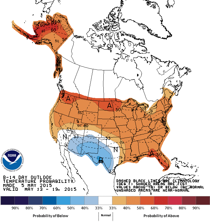
Extended Temperature Outlook
Those who are enjoying the mild weather as of late may enjoy the forecast below! According to NOAA's CPC, the 8 to 14 day temperature outlook suggests above average temperatures returning for mid May (May 13th - 19th)! There will be a brief cool down before then, but it should only last a few days.
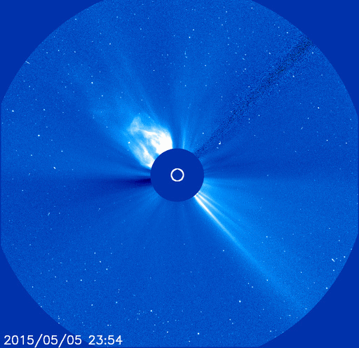
May 5th X-Flare
"The sun is no longer quiet. Emerging sunspot AR2339 unleashed an intense X2-class solar flare on May 5th at 22:11 UT. NASA's Solar Dynamics Observatory captured the extreme ultraviolet flash:"
Read more from SpaceWeather.com HERE:
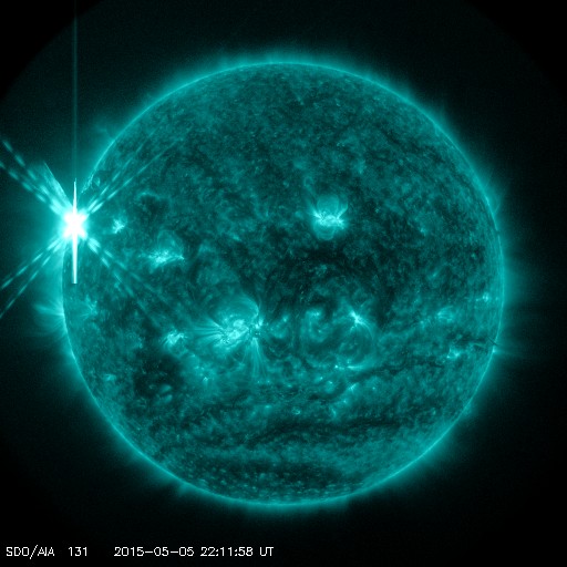
"A pulse of UV radiation and X-rays from the flare caused a strong radio blackout over the Pacific side of Earth. This map shows the extent of the blackout, which affected frequencies below 20 MHz. Mariners, aviators, and ham radio operators are the type of people who might have noticed the disturbance.
The explosion also hurled a CME into space: movie. Traveling faster than 1100 km/s (2.5 million mph), the expanding cloud does not appear to be heading for Earth."
Read more from SpaceWeather.com HERE:
________________________________________________________________
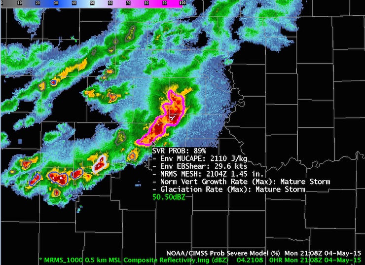
"A New Tool for Gauging the Odds that a Storm Will Turn Severe"
Here's an interesting post from Jeff Masters Wunderblog about new technology that could help forecasters in determining and storm will become severe.
Read more from Jeff Masters' Wunderblog HERE:
"Will that thunderstorm become severe? It’s a question asked countless times each spring across the nation’s severe-weather corridors, not only by the public but also by forecasters in the National Weather Service. NOAA’s Storm Prediction Center issues convective outlooks that paint the broad picture of where severe weather is expected each day over the next week. SPC also coordinates with local offices on the placement of severe weather watches. It’s then up to local NWS forecasters to keep track of fast-breaking storm evolution and issue the county-scale warnings that millions of people act on. According to NWS severe storm services leader John Ferree, NWS offices issued more than 22,000 tornado warnings and more than 145,000 severe thunderstorm warnings in the seven-year period from 2008 through 2014."
"At 4:08 pm CDT Monday, the NOAA/CIMSS ProbSevere model assigned an 89% chance that the storm shown here (outlined in magenta) in far northeast Kansas will produce its first instance of severe weather over the next hour. The probability is based on a statistical blend of the five indices shown in the text block next to the storm. These refer to instability, wind shear, hail size, the storm’s vertical growth rate, and glaciation (the pace of ice crystal formation within the thunderstorm). One of the forecast teams issued a non-public experimental severe thunderstorm warning at 4:17 pm CDT. No severe reports had come in by Tuesday morning for the time period of the warning, but in many cases severe weather in sparsely populated areas cannot be confirmed—and of course, even an 89% chance of severe weather means that no severe reports would be expected 11% of the time"
(Image credit: Kristin Calhoun, National Severe Storms Laboratory)
____________________________________________________
Thanks for checking in and have a great rest of your week! Don't forget to follow me on Twitter @TNelsonWX

No comments:
Post a Comment