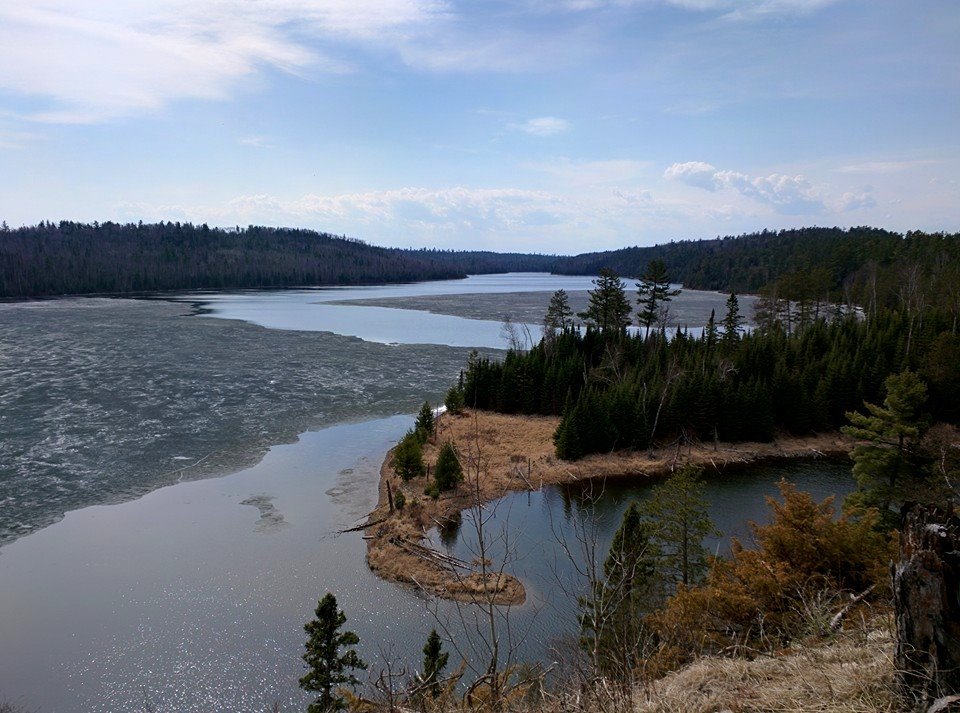
Thanks to my good friend Lee Huffman for the picture below. He was in Northeastern Minnesota this weekend and happened to find a few lakes with a little ice still left on them! This picture was taken on the Caribou Rock Trail, which is near the Gunflint Trail north of Grand Marais, MN. Thanks Lee!
2015 Ice Outs
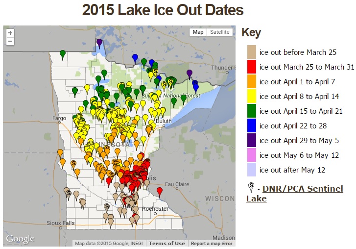
The map below from the MN DNR shows a number of lakes across the state are now currently ice out. Late last week, ice out was reported for Lake of the Woods and Sea Gull Lake in far northern Minnesota. Interestingly, this was near average for those lakes.
____________________________________________________________
Much Needed Rain
By Todd Nelson
According to the U.S. Drought Monitor, nearly 92 percent of the state is considered to be in a moderate drought, while 32 percent of the state is under a severe drought. One year ago, only 23 percent of the state was abnormally dry and only 8 percent was under a moderate drought.
Keep in mind that snowfall this season was quite low across the state. St. Cloud will end nearly 15 inches below the seasonal average, Minneapolis will finish nearly 2 feet below the seasonal average and Duluth nearly 3 feet below the seasonal average! With that said, parts of the state are currently 2 to nearly 3 inches below average precipitation since January 1st, so the well timed rainfall this week is much needed.
Forecasts continue to suggest nearly 1 inch or more of convective rainfall possible across parts of the state through the end of the week. The good news is that we dry out just in time for the walleye opener this Saturday, but heavy downpours could make for a fairly soggy Mother's Day.
In the meantime, keep an eye on the forecast near Savannah, GA where sub-tropical storm Ana could form by late this week! Yes, it's a bit early. The Atlantic Hurricane Season starts June 1st.
______________________________________________________________
MONDAY NIGHT: Clouds increase. Chance of a shower or thunderstorm late across far southern MN late. Low: 51. Winds: E 5mph
TUESDAY: Cooler with more clouds across southern half of state. Showers and storms arrive late, mainly in southern MN. High: 66. Winds: ESE 10-15
TUESDAY NIGHT: Cloudy. Chance of spotty showers and storms. Low: 54. Winds: ESE 10-15.
WEDNESDAY: Breezy. Rain with spotty thunder. High: 73
THURSDAY: Scattered showers and storms. Heavy PM downpours possible. Wake-up: 61. High: 76
FRIDAY: Breezy. Cooler by the afternoon with spits of rain. Wake-up: 57. High: 71.
SATURDAY: Looks mostly dry for the Walleye opener. Cooler. Wake-up: 54. High: 66.
SUNDAY:Soggy Mother's Day. Scattered showers and thunderstorms. Wake-up: 53. High: 70.
MONDAY: Lingering showers, flakes up north? Wake-up: 51. High: 60.
_______________________________________________________
This Day in Weather History
May 5th
1965: At least 7 tornadoes hit southern Minnesota. It was a preview to what would happen the next day.
_______________________________________________________
Average High/Low for Minneapolis
May 5th
Average High: 66F (Record: 89F set in 2000)
Average Low: 45F (Record: 27F set in 1989)
______________________________________________________
Sunrise/Sunset Times for Minneapolis
May 5th
Sunrise: 5:57am
Sunset: 8:23pm
______________________________________________________
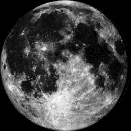
Moon Phase for May 5th at Midnight
2.1 Days After Full Moon
______________________________________________________
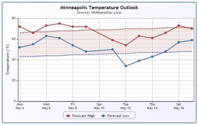
Minneapolis Temperature Trend
After an incredibly mild weekend and start to the week, temperatures take a bit of a hit on Tuesday. Interestingly, the cooler temperatures expected on Tuesday is actually close to our average high for early May! If you've been a big fan of the recent mild weather, temperatures will have no problem getting to above average levels through the rest of the week. There may be a bigger cool down headed our way by this time next week. Stay tuned.
_____________________________________________________
Tuesday Temperature Outlook
The same front that brought strong to severe thunderstorms to parts of Minnesota on Sunday will lift north back into the region on Tuesday keeping things a little cool, cloudy and unsettled. Keep in mind that the highs expected on Tuesday are highs a little closer to where we should be for early May.
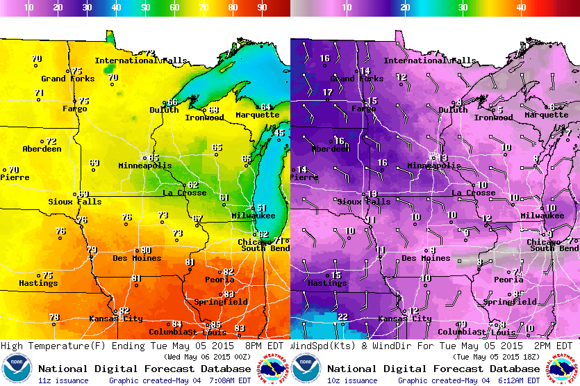
Tuesday Weather Outlook
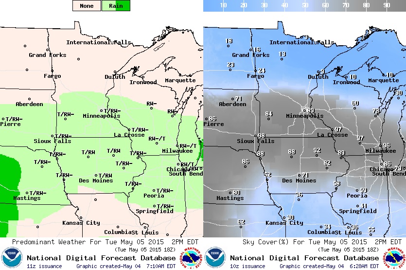
Clouds will be more prevalent across the southern part of the state on Tuesday as the front slowly slides north. There will also be a better chance of spotty showers and isolated thunderstorms across the southern part of the state, while the northern part of the state looks to remain milder and sunnier!
_______________________________________________________________
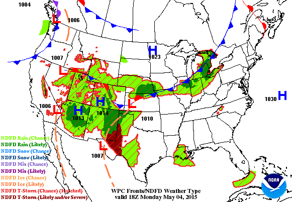
National Weather Outlook
Soggy weather continues across the middle part of the country with consecutive days of shower and thunderstorm activity. Some of the thunderstorms over the next several days could be strong to severe with heavy rainfall and flooding potential. Also note the rain showing up across Florida. This particular system could make for an interesting second half of week along the southeastern U.S. coastline.
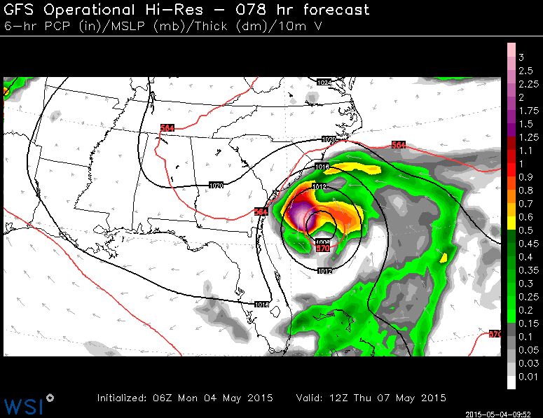
Rogue Tropical System?
Now this is interesting. Extended model runs continue to indicate a random area of low pressure developing by midweek east of Florida. The forecast brings the area of low pressure near the Carolina Coast by AM Thursday before moving inland AM Friday near Savannah, Georgia. Heavy rains and gusty winds look to be the primary threat with this particular system. While not necessarily a significantly strong storm system, it's an interesting trend.
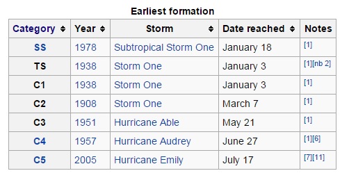
Atlantic Hurricane Records: Earliest Formation for each Category
Keep in mind that the official Atlantic Hurricane Season is from June 1st - November 30th. On average, this is when nearly 97% of all Atlantic based tropical systems have formed. The list below shows the earliest formation recorded for each category and note the earliest Sub-tropical Storm, Tropical Storm and Category 1 Hurricane formation on record all developed in January.
See more from Wikipedia HERE:
_______________________________________________________________
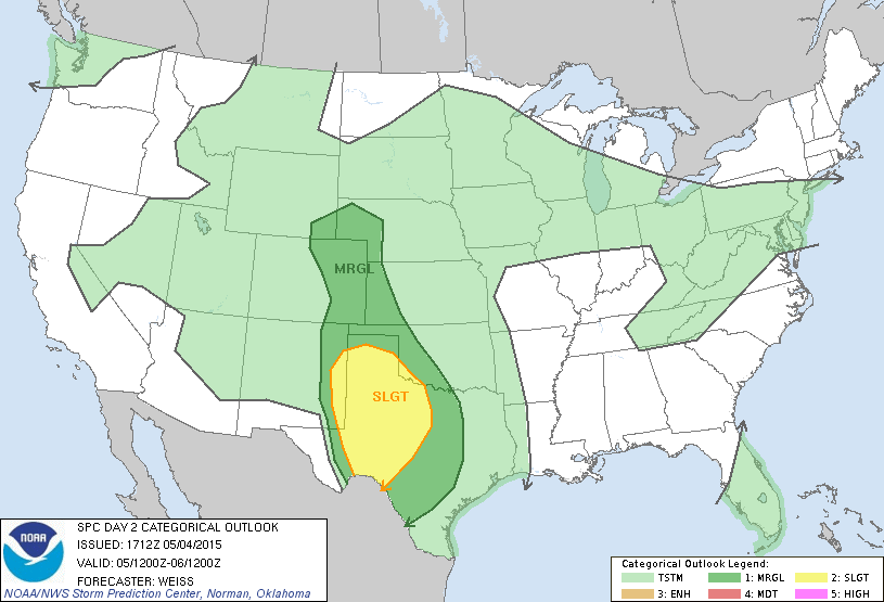
Severe Threat Tuesday
...SUMMARY...
SCATTERED STRONG TO SEVERE THUNDERSTORMS WILL BE POSSIBLE TUESDAY
ACROSS PARTS OF THE CENTRAL HIGH PLAINS INTO THE SOUTHERN PLAINS.
...SYNOPSIS...
A LONG-WAVE TROUGH WILL BECOME ESTABLISHED ACROSS THE WRN HALF OF
THE CONUS TUESDAY AS A LOWER LATITUDE SHORT-WAVE TROUGH NOW OVER THE
LOWER CO VALLEY/NRN BAJA REGION MOVES EWD/NEWD ACROSS THE
CENTRAL/SRN ROCKIES...AND AN UPSTREAM COLD UPPER LOW OFF BC DIGS
SEWD ACROSS BC AND THE PACIFIC NORTHWEST.
AT THE SURFACE...A BROAD LOW PRESSURE AXIS OVER THE WEST WILL
GRADUALLY SHIFT EWD AND BECOME BETTER DEFINED IN THE IMMEDIATE LEE
OF THE ROCKIES. A NORTH-SOUTH DRY LINE WILL OVER THE CENTRAL/SRN
HIGH PLAINS IS FORECAST TO INITIALLY MIX/SHIFT EWD ACROSS PARTS OF
THE SRN HIGH PLAINS INTO THE EVENING HOURS BEFORE RETREATING WWD
DURING THE NIGHT.
...SRN HIGH PLAINS...
AREAS OF STRONG CONVECTION MAY BE ONGOING EARLY IN THE PERIOD FROM
PARTS OF ERN NM/W TX INTO SWRN KS IN ADVANCE OF THE SWRN STATES
SHORT-WAVE TROUGH. THIS ACTIVITY IS LIKELY TO SPREAD NEWD DURING THE
DAY WITH POTENTIAL FOR MARGINAL HAIL AND OCCASIONAL STRONG WIND
GUSTS. IN THE WAKE OF THE INITIAL CONVECTIVE STORMS...DIABATIC
HEATING OVER ERN NM/W TX WILL COMBINE WITH COOLING ALOFT AND THE ERN
EDGE OF STEEPER MID-LEVEL LAPSE RATES TO PROMOTE STRONGER
INSTABILITY WITH MLCAPE REACHING 1000-1500 J/KG. REDEVELOPMENT OF
STORMS IS EXPECTED DURING THE AFTERNOON NEAR THE DRY LINE AS DYNAMIC
FORCING FOR LARGE-SCALE ASCENT OVERSPREADS THE AREA FROM THE WEST.
WIND PROFILES ARE EXPECTED TO VEER AND INCREASE IN SPEED WITH HEIGHT
AS A BROAD ZONE OF 35-45 KT MID-LEVEL WINDS ADVANCES NEWD ACROSS THE
SRN HIGH PLAINS. THIS WILL ENHANCE STORM ORGANIZATION AND INTENSITY
INCLUDING POTENTIAL FOR SUPERCELL STRUCTURES TO DEVELOP. LARGE
HAIL...DAMAGING WIND GUSTS AND ISOLATED TORNADOES WILL BE POSSIBLE
WITH STRONGER CELLS THROUGH THE EVENING HOURS. THIS ACTIVITY MAY
ORGANIZE INTO ONE OR MORE LOOSELY ORGANIZED MCS/S THAT WILL CONTINUE
NEWD ACROSS PARTS OF OK INTO KS THROUGH THE OVERNIGHT HOURS...BUT
DECREASING INSTABILITY WITH NEWD EXTENT IS EXPECTED TO LIMIT OVERALL
NOCTURNAL SEVERE POTENTIAL.
FARTHER EAST OVER PARTS OF CENTRAL/N CENTRAL TX...MULTIPLE MODELS
/NAM..GFS..ECMWF..UKMET..EXPERIMENTAL NCAR ENKF ENSEMBLE/ INDICATE
DEVELOPMENT OF A SEPARATE AREA OF STRONG CONVECTION WITHIN A WEAKLY
CAPPED ENVIRONMENT BENEATH A DIFFLUENT MID-UPPER LEVEL FLOW PATTERN.
AS STRONGER WINDS ALOFT SPREAD EWD TOWARD CENTRAL TX...DEEP-LAYER
SHEAR IS FORECAST TO INCREASE WITH POTENTIAL FOR A FEW STRONG TO
SEVERE STORMS /INCLUDING ISOLATED SUPERCELLS/. ACCORDINGLY...THE
5%-MARGINAL RISK AND 15%-SLIGHT RISK CONTOURS HAVE BEEN ADJUSTED EWD
INTO PARTS OF CENTRAL/N CENTRAL TX.
Severe Threat Wednesday
...SYNOPSIS...
AMPLIFICATION OF THE MID-LATITUDE WESTERLIES ACROSS THE NORTH
CENTRAL AND NORTHEASTERN PACIFIC THROUGH THE WESTERN U.S. APPEARS
LIKELY TO CONTINUE DURING THIS FORECAST PERIOD. WITHIN THIS
REGIME...THE ELONGATING SOUTHERN PORTION OF A SPLITTING SHORT WAVE
IMPULSE IS FORECAST TO CONTINUE DIGGING JUST INLAND OF THE PACIFIC
COAST. DOWNSTREAM SHORT WAVE RIDGING WILL PROBABLY BUILD ACROSS THE
CENTRAL AND SOUTHERN ROCKIES...INTO ADJACENT PORTIONS OF THE CENTRAL
AND SOUTHERN PLAINS...IN THE WAKE OF A SHORT WAVE TROUGH EXPECTED TO
EMERGE FROM THE SOUTHERN INTERMOUNTAIN REGION ON TUESDAY.
THIS IMPULSE...WHICH IS EXPECTED TO REACH THE CENTRAL PLAINS BY 12Z
WEDNESDAY...MAY TEND TO SHIFT MORE NORTHWARD THAN EASTWARD THROUGH
THE MID MISSOURI VALLEY...WITH A MID-LEVEL HIGH CENTER INITIALLY
FAIRLY PROMINENT NEAR THE CENTRAL APPALACHIANS...TO THE NORTH OF A
DEVELOPING CYCLONE OFF THE SOUTH ATLANTIC COAST /ASSOCIATED WITH
UPPER TROUGHING IN THE SUBTROPICAL STREAM/. AS THIS OCCURS...MODELS
INDICATE THAT LOW PRESSURE WILL CONTINUE TO DEEPEN WITHIN THE
NORTHERN PORTION OF LEE SURFACE TROUGHING SHIFTING OUT OF THE
NORTHERN AND CENTRAL HIGH PLAINS...TOWARD THE LOWER PLAINS. A
GRADUAL FURTHER MOISTENING OF LOWER LEVELS AHEAD OF THE TROUGH AXIS
IS EXPECTED TO PROCEED ON MODERATE SOUTHERLY LOW-LEVEL FLOW.
...CENTRAL AND SOUTHERN PLAINS...
CONVECTIVE CLOUD COVER AND PRECIPITATION CURRENTLY APPEARS LIKELY TO
LIMIT BOUNDARY LAYER DESTABILIZATION AHEAD OF THE NORTH
NORTHEASTWARD PROGRESSING SHORT WAVE IMPULSE. IN THE WAKE OF THIS
FEATURE...HOWEVER...IT DOES APPEAR THAT SURFACE HEATING... BOUNDARY
LAYER MOISTENING /SURFACE DEW POINTS IN THE LOWER TO MID 60S/...AND
AT LEAST MODEST STEEPENING OF MID-LEVEL LAPSE RATES WILL CONTRIBUTE
TO MODERATE MIXED LAYER CAPE ALONG A SHARPENING DRY LINE BY LATE
AFTERNOON. DUE TO THE LACK OF WARMER ELEVATED MIXED LAYER
AIR...CAPPING SHOULD NOT BE PROHIBITIVE TO CONVECTIVE DEVELOPMENT.
SO...DESPITE WEAKER MID/UPPER FORCING FOR UPWARD VERTICAL
MOTION...THE INITIATION OF AT LEAST WIDELY SCATTERED DISCRETE STORMS
APPEARS PROBABLE. AS 30-40+ KT CYCLONIC MID-LEVEL FLOW TAKES ON A
MORE WESTERLY COMPONENT IN THE IMMEDIATE WAKE OF THE UPPER
IMPULSE...CONTRIBUTING TO STRONG DEEP LAYER SHEAR...THERE APPEARS A
WINDOW OF OPPORTUNITY FOR A FEW SUPERCELLS CAPABLE OF PRODUCING
LARGE HAIL...LOCALLY DAMAGING WIND GUSTS...PERHAPS A COUPLE OF
TORNADOES.
IT REMAINS UNCLEAR HOW DEEP INTO THE EVENING THIS SEVERE THREAT WILL
PERSIST...AS MID-LEVELS TEND TO WARM...AND THE DRYLINE RETREATS
WESTWARD TOWARD THE HIGHER PLAINS.
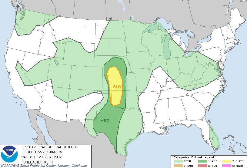
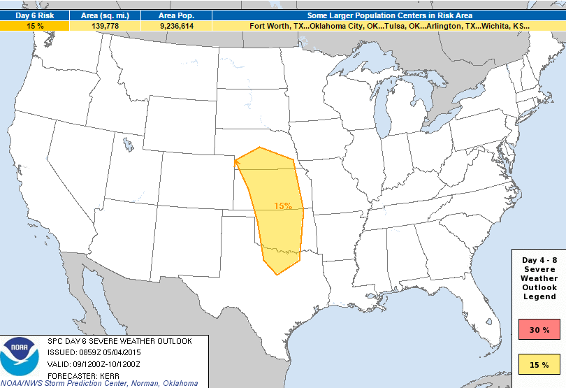
Severe Threat Saturday?
Interestingly, the Storm Prediction Center has already issued a thunderstorm outlook across parts of the Plains for Saturday. Another storm system looks to develop late week/early weekend near the Four Corners Region and bring another potential round of strong to severe thunderstorms to the parts of the Plains. Stay tuned!
...DISCUSSION... UNCERTAINTY WITHIN THE MEDIUM RANGE MODEL OUTPUT...CONCERNING AN AMPLIFYING SHORT WAVE TROUGH EMERGING FROM A STRONGER BELT OF MID-LATITUDE WESTERLIES...DIGGING JUST INLAND OF THE PACIFIC COAST AT THE OUTSET OF THE FORECAST PERIOD...APPEARS TO BE DECREASING. IN GENERAL...IT APPEARS THAT AN EMBEDDED MID-LEVEL LOW WILL EVOLVE AS THIS IMPULSE GRADUALLY TURNS ACROSS THE SOUTHERN GREAT BASIN...TOWARD THE FOUR CORNERS REGION...LATE THIS WEEK. PHASING WITH THE SUBTROPICAL STREAM DOES APPEAR POSSIBLE...BEFORE THIS SYSTEM BEGINS ACCELERATING EAST NORTHEASTWARD. GUIDANCE CONTINUES TO INDICATE SATURDAY AS THE MOST LIKELY DAY THAT THIS IMPULSE EMERGES FROM SOUTHERN INTERMOUNTAIN REGION...CONTRIBUTING TO A DEEPENING SURFACE CYCLONE OVER THE CENTRAL HIGH PLAINS. INCREASING LARGE-SCALE FORCING FOR ASCENT...STRENGTHENING VERTICAL SHEAR...AND THE CONTINUING PRESENCE OF MOIST...POTENTIALLY UNSTABLE AIR PROBABLY WILL BE SUFFICIENT TO SUPPORT ORGANIZED SEVERE CONVECTION...INCLUDING SUPERCELLS...ACROSS THE CENTRAL AND SOUTHERN PLAINS. AS THIS UPPER IMPULSE...AND ASSOCIATED SURFACE CYCLONE...PROGRESS EASTWARD IN SUBSEQUENT DAYS...SEVERE PROBABILITIES REMAIN BELOW 15 PERCENT AT THIS TIME DUE TO INCREASING UNCERTAINTIES/DECREASING PATTERN PREDICTABILITY.
____________________________________________________________
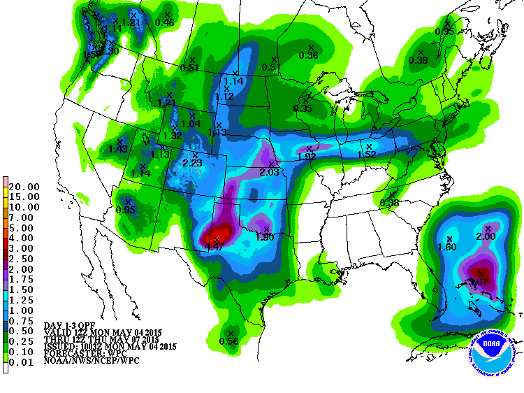
3 Day Precipitation Outlook
According to NOAA's HPC, the 3 day precipitation forecast from AM Monday to AM Thursday suggests heavier pockets of rain across parts of the Plains. Thanks to some convective precipitation, rainfall tallies through AM Thursday could be as much as 2" to 4" or more.
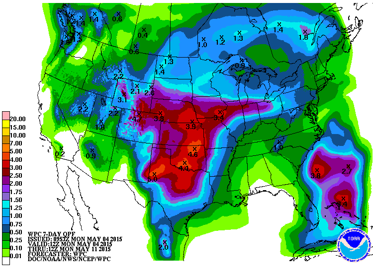
7 Day Precipitation Outlook
Ongoing shower and thunderstorm potential across the midsection of the nation could produce as much as 3" to nearly 5" or more of rain by early next week. Keep in mind that some of the heavy rain could come in a fairly short amount of time, so flooding may be a concern.
_______________________________________________________________
"Tesla's new $3,500 10kWh Powerwall home battery lets you ditch the grid"
"Tesla’s long awaited home battery is now on the market. Late in the evening on April 30, Tesla CEO Elon Musk kept his promise for his hotly anticipated announcement about the company’s next product line. Musk admitted the week prior that the announcement would indeed be about the home battery he promised earlier in the year, the details of which have been quite secretive until, well, the announcement. Musk took the stage at 8pm PST on a Thursday evening to make the announcement, in which he wowed the crowd by directing people to the Tesla website, where the stationary battery is already available for pre-order and scheduled to ship within a few months."
"With this announcement, Tesla has fulfilled the conclusion posited by Wired last week: they are no longer a car company. Tesla is now a battery company first, and a car company second. Tesla isn’t creating a new market, though. The Tesla Powerwall is not exactly the first home battery of its kind. Others exist. Most home batteries function approximately like this: batteries charge at night, when utility company’s rates are the lowest, and can then be switched on in the morning so homeowners can enjoy that cheap energy throughout the day. Batteries, as we all understand, can be juiced up from nearly any source – including a homeowner’s solar panels, provided the correct wiring is available. So, could the new Tesla battery be used to take your home off the grid?"
Read more from Inhabitat.com HERE:

_____________________________________________________________
Thanks for checking in and have a great week ahead! Don't forget to follow me on Twitter @TNelsonWX

No comments:
Post a Comment