Thanks to Lynn Garbel Sieme for the pictures below out of Blackhawk, SD. Lynn was telling me that her kids thought it was the best Mother's Day gift ever! See below for more on the heavy snow in South Dakota.


50 Shades of Green
By Todd Nelson
I have to admit, I like the color green. Not sure why, but maybe it's because I've been a Minnesotan my entire life and the color green is hard to come by. Keep in mind that leaves are typically only on trees here in Minnesota for about 5 months. From May to October, trees actually look like trees are supposed to.
Interestingly, the growing season across parts of northeastern Minnesota is typically less than 100 days, while parts of southern Minnesota have a growing season that is a little more than 150 days. With that said, the recent mild weather has prompted many to flock to local garden centers in search of some summer color. The good news is that if you've busy in the garden, you can rest easy knowing that southern Minnesota will stay frost free through the week ahead. However, parts of northern Minnesota could be dealing with snow tonight and early Tuesday!
The storm system that brought parts of the Black Hills nearly 1 to 2 feet of snow this weekend, will keep us cool through the first half of the week. May-like weather looks to return by next weekend with highs in the 70s!
I am predicting green lawns and skeeters by the end of the month. -Todd Nelson
___________________________
SUNDAY NIGHT: Spotty showers and storms. Low: 51. Winds: E 10-15
MONDAY: Cloudy with lingering showers. High: 63. Winds: SSW 10-15.
MONDAY NIGHT: Breezy with lingering showers. Light snow up north. Low: 41. Winds: WNW 10-15
TUESDAY: AM Flakes up north. Breezy and cool with lingering showers. High: 53.
WEDNESDAY: Mix of clouds and sun. PM shower?. Wake-up: 41. High: 58.
THURSDAY: Getting there. Spotty showers and an isolated rumble of thunder? Wake-up: 48. High: 62.
FRIDAY: Feels like May again. Spotty shower. Wake-up: 52. High: 70.
SATURDAY: Mild with a mix of clouds and sun. Wake-up: 53. High: 73.
SUNDAY: Thundery. Wetter day of the weekend. Wake-up: 56. High: 74.
______________________________
This Day in Weather History
May 11th
1915: A waterspout was seen at Lake Mills.
_____________________________
Average High/Low for Minneapolis
May 11th
Average High: 68F (Record: 88F set in 1900)
Average Low: 47F (Record: 27F setin 1946)
________________________________
Sunrise/Sunset Times for Minneapolis
May 11th
Sunrise: 5:49am
Sunset: 8:30pm
________________________________
Moon Phase for May 11th at Midnight
0.8 Days After Last Quarter

____________________________________
Minneapolis Temperature Trend
It'll be a cool start to the week with temperatures dipping into the 50s for highs. May-like temperatures return by the end of the week/weekend with highs getting back to into the 70s.

Monday Weather Outlook
The center of the low pressure system will move through the state of Minnesota on Monday with cool, showery weather. Temperatures will range from the 30s and 40s across the northern part of the state to the 50s and 60s across the southern part of the state.

Monday Weather Outlook
The heaviest and steadiest rain will be found across the northern part of the state on Monday mixed with a few wet flakes at times. The best chance of snow will be Monday night across the international border.

Simulated Radar
Spotty showers and storms from Sunday will move into northern Minnesota on Monday with a few snowflakes mixing in overnight through AM Tuesday.

Rainfall Potential
Precipitation potential through from PM Sunday to PM Tuesday suggests as much as 0.50" to 1.5" possible. Keep in mind that parts of northwestern Minnesota may need 5" to 7" of rain to end the drought.

Snowfall Potential
The snowfall potential across parts of northern Minnesota could feature as much as 1" to 2" by PM Tuesday

Crazy Snow
Take a look at the image below from the Crazy Horse Memorial in the Black Hills of South Dakota. Heavy snow of 1ft. to nearly 2ft fell over the weekend!
Here's the latest view from the Crazy Horse Viewing Deck

Snowfall Tallies
Here were the snowfall tallies from earlier Sunday. Note the several 12"+ snowfall reports from near Downtown Rapid City and Lead.

Average May Snowfall For Rapid City, SD
Interestingly, the average snowfall for Rapid City, SD in May is a little more than 1"

Average May Snowfall For Lead, SD
However, the average May snowfall for Lead, SD is 8"!

Average May Snowfall for Mount Rushmore National Memorial
The average snowfall for May at the Mount Rushmore National Memorial is 1.2"

_______________________________________________
ANA Satellite Loop
Tropical Storm ANA made landfall in eastern South Carolina early Sunday morning with some heavier pockets of rain and gusty winds. The satellite loop shows sunrise on Sunday morning as winds were near 60mph. Ana quickly fell part as it moved inland during the day Sunday.

___________________________________________________
National Weather Outlook
The storm system wrapping up across the middle part of the county week will be responsible for heavy pockets of rain and thunder through early next week. Snowfall chances will deteriorate rapidly across the Upper Midwest by early next week too!

Severe Threat Monday
...SUMMARY...
SCATTERED THUNDERSTORMS ARE EXPECTED TO DEVELOP ALONG A COLD FRONT
FROM LOWER MICHIGAN TO CENTRAL TEXAS. ISOLATED DAMAGING WINDS AND
SOME HAIL ARE THE PRIMARY THREATS.
...DISCUSSION...
UPPER TROUGH WILL TRANSLATE FROM THE PLAINS INTO THE MID-UPPER MS
VALLEY BY 12/00Z...EWD INTO THE GREAT LAKES BY THE END OF THE PERIOD
AS SPEED MAX INTENSIFIES FROM MO INTO INDIANA DURING THE LATTER HALF
OF THE PERIOD. LARGE-SCALE HEIGHT FALLS WILL CONCENTRATE NORTH OF
THE OH RIVER AND THE MOST DYNAMICALLY DRIVEN/FORCED PORTION OF THE
COLD FRONT WILL SWEEP ACROSS IL INTO INDIANA DURING THE DAYTIME
HOURS.
EARLY MONDAY MORNING...CONVECTION WILL LIKELY BE ONGOING ALONG THE
WIND SHIFT FROM WI...SWD ACROSS IL/MO INTO CNTRL TX. CONSIDERABLE
CLOUDS/PRECIPITATION...COMBINED WITH MOIST PROFILES AND MODEST LAPSE
RATES DO NOT FAVOR STRONG INSTABILITY AHEAD OF THE COLD
FRONT...EXCEPT ACROSS PORTIONS OF TX AND THE LOWER SABINE RIVER
VALLEY.
LATEST THINKING IS STRONGLY SHEARED FRONTAL CONVECTION WILL ADVANCE
EWD EXHIBITING LINEAR CHARACTERISTICS FAVORABLE FOR GUSTY WINDS AND
PERHAPS SOME HAIL WITH THE STRONGEST UPDRAFTS. LARGE-SCALE FORCING
SUGGESTS MOST-ORGANIZED CONVECTION MAY EVOLVE ALONG NRN PORTIONS OF
THE FRONT WHERE WEAKEST INSTABILITY IS EXPECTED. FARTHER
SOUTH...SHALLOW COLD FRONT AND WEAKER LOW-LEVEL CONVERGENCE MAY
PROVE PROBLEMATIC IN MAINTAINING SQUALL LINE NATURE ACROSS TX EARLY
IN THE PERIOD. HOWEVER...STRONG HEATING ACROSS TX DURING THE DAY
SHOULD ENCOURAGE THUNDERSTORM DEVELOPMENT ALONG SLOW-MOVING BOUNDARY
BY LATE AFTERNOON. LARGE HAIL WILL BE MOST COMMON FROM TX INTO NRN
LA AS THIS ACTIVITY MATURES AND LINGERS INTO THE OVERNIGHT HOURS.
...TROPICAL SYSTEM ANA...
GUSTY WINDS MAY ACCOMPANY STRONGEST CONVECTION ALONG ERN PERIPHERY
OF TROPICAL SYSTEM ANA. MAJORITY OF THIS ACTIVITY SHOULD REMAIN
MARGINALLY SEVERE AT BEST.

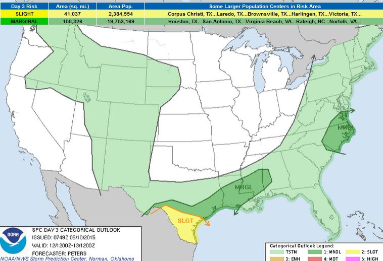
Severe Threat Tuesday
...SUMMARY...
ISOLATED TO SCATTERED STRONG TO SEVERE STORMS WILL BE POSSIBLE ON
TUESDAY FROM SOUTH TEXAS TO THE LOWER MISSISSIPPI VALLEY AND PART OF
THE CENTRAL GULF COAST STATES. ISOLATED STRONG TO SEVERE STORMS
WILL ALSO BE POSSIBLE TUESDAY AFTERNOON ACROSS EASTERN NORTH
CAROLINA AND SOUTHEAST VIRGINIA.
...SOUTH TX TO THE CENTRAL GULF COAST STATES...
THE TRAILING PORTION OF THE ERN STATES COLD FRONT IS EXPECTED TO
MOVE SWD ACROSS THE CENTRAL GULF COAST STATES AND LA...WHILE THE WRN
EXTENT BECOMES QUASI-STATIONARY IN SRN OR CENTRAL TX. A FEW WEAK
MIDLEVEL IMPULSES TRACKING ACROSS S TX TO THE LOWER MS VALLEY MAY
PROVE FAVORABLE IN SUPPORTING ISOLATED TO SCATTERED TSTM
DEVELOPMENT. THE AIR MASS ACROSS SOUTH TX IS EXPECTED TO REMAIN
MODERATELY UNSTABLE AND COMBINED WITH STRONG EFFECTIVE BULK SHEAR
WILL SUPPORT AN ENVIRONMENT FAVORABLE FOR ORGANIZED STORMS. GIVEN
WEAK FORCING ALOFT...THE UNCERTAINTY IN TIMING AND GENERAL PLACEMENT
OF NEW TSTM DEVELOPMENT THROUGH TUESDAY PRECLUDES THE EXPANSION OF
THE SLIGHT RISK AREA. WEAKER DEEP-LAYER SHEAR WITH EWD EXTENT INTO
THE LOWER MS VALLEY TO PARTS OF MS AND WRN AL SUGGESTS THE SEVERE
RISK SHOULD REMAIN MARGINAL...DESPITE THE PRESENCE OF STRONG
INSTABILITY. STORMS IN THIS LATTER REGION SHOULD DEVELOP ALONG THE
COLD FRONT AS IT MOVES SOUTH.
...NEW ENGLAND TO ERN VA/NC...
A PROGRESSIVE TROUGH LOCATED ACROSS THE GREAT LAKES AND OH VALLEY
EARLY TUESDAY MORNING WILL ADVANCE EWD WITH SOME WEAKENING DURING
THE FIRST HALF OF DAY 3. RE-AMPLIFICATION OF THIS TROUGH IS
EXPECTED TUESDAY NIGHT AS A SEWD-MOVING SHORTWAVE TROUGH FROM NRN
ONTARIO PHASES WITH THE GREAT LAKES/OH VALLEY TROUGH ACROSS NEW
ENGLAND. IN THE WAKE OF THESE SYSTEMS...HEIGHT RISES ARE EXPECTED
ACROSS MUCH OF THE GREAT PLAINS INTO THE MID MS VALLEY AND UPPER
MIDWEST. A COLD FRONT WILL ADVANCE EWD ACROSS MUCH OF THE ERN
STATES TUESDAY AND MOVE OFF THE ATLANTIC COAST.
THE POTENTIAL WILL EXIST FOR A FEW STRONG TO SEVERE STORMS ACROSS
SERN VA INTO ERN NC TUESDAY AFTERNOON WHERE THE AIR MASS SHOULD
BECOME MODERATELY UNSTABLE. SOME UNCERTAINTY EXISTS WITH HOW STRONG
EFFECTIVE BULK SHEAR WILL BE IN THIS REGION...WITH SERN VA AND NERN
NC POTENTIALLY HAVING THE STRONGEST SHEAR FOR ORGANIZED STORMS.
GIVEN WEAK FORCING ALOFT IS FORECAST ACROSS SERN VA AND ERN NC
SUGGESTING LESS STORM COVERAGE...LOW SEVERE PROBABILITIES WILL BE
INTRODUCED AT THIS TIME. ALTHOUGH FORCING FOR ASCENT WILL BE
STRONGER ACROSS NEW ENGLAND...INSTABILITY IS EXPECTED TO BE MARGINAL
AT BEST INTO SRN NEW ENGLAND...SUGGESTING THE THREAT FOR SEVERE
STORMS WILL REMAIN LESS THAN 5 PERCENT.
_____________________________________
3 Day Precipitation
According to NOAA's HPC, the 3 day precipitation forecast shows the heaviest of the moisture across the central part of the country started to fade a bit. However, some across eastern Texas could see as much as 3" to 6" by PM Wednesday.

7 Day Precipitation
The long range forecast through next week suggests even more rainfall potential across middle part of the country. Also note the additional precipitation moving back into the Western U.S.!

_________________________________
Thanks for checking in and have a great week ahead! Don't forget to follow me on Twitter @TNelsonWX

No comments:
Post a Comment