
_____________________________________________
Onward and upward
By Todd Nelson
I encountered a pothole from another planet Monday morning. MN DOT called it a partial road collapse. My damage assessment from the I-494 twilight experience? Two blown tires, spilled coffee and a dirty suit. All things considered, it could have been worse. I just feel bad for the gals that limped up behind me, they missed their flight to Florida. Talk about a case of the Mondays!
While the calendar says Spring, Winter and road construction seem to be the only two seasons that commuters are familiar with. Dealing with Minnesota roads and weather can sometimes feel like an uphill battle. The good news is that you'll likely seem more noticeable changes in the weather department by the upcoming weekend as highs warm into the 70s.
In the meantime, folks across northern Minnesota may see a few more flakes early today, while spits of rain and cooler than average temps continue for the rest of us. Heavier, steadier rains look to return Thursday and perhaps again this Sunday. At this rate, we'll cut into that drought in no time. However, I may have to invest in a herd of goats to tackle the lawn. It's starting to look like a jungle out there!
______________________________
MONDAY NIGHT: Breezy with lingering showers. Light snow up north. Low: 41. Winds: NW 10-15
TUESDAY: AM Flakes up north. Breezy and cool with lingering AM showers. A little more PM sun. High: 55. Winds: NW 15-25
TUESDAY NIGHT: Nothing rough. Low: 41. Winds: NW turning E 5-15
WEDNESDAY: Mix of clouds and sun. PM shower?. High: 60.
THURSDAY: Another soggy day with a few rumbles of thunder. Wake-up: 50. High: 62.
FRIDAY: Warmer and not as wet.. Wake-up: 52. High: 70.
SATURDAY: Warm with storms late. Wake-up: 56. High: 76.
SUNDAY: Thundery. Wetter day of the weekend. Wake-up: 58. High: 77.
MONDAY: A brisk breeze develops. Wake-up: 54. High: 64.
______________________________
This Day in Weather History
May 12th
1922: From shorts to sweaters at Morris. The temperature dropped from 91 to 26.
_____________________________
Average High/Low for Minneapolis MN
May 12th
Average High: 68F (Record: 88F set in 1900)
Average Low: 47F (Record: 27F set in 1946)
_____________________________
Sunrise/Sunset Times for Minneapolis
May 12th
Sunrise: 5:48am
Sunset: 8:31pm
______________________________
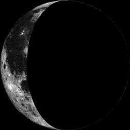
Moon Phase for May 12th at Midnight
1.8 Days After Last Quarter
___________________________________
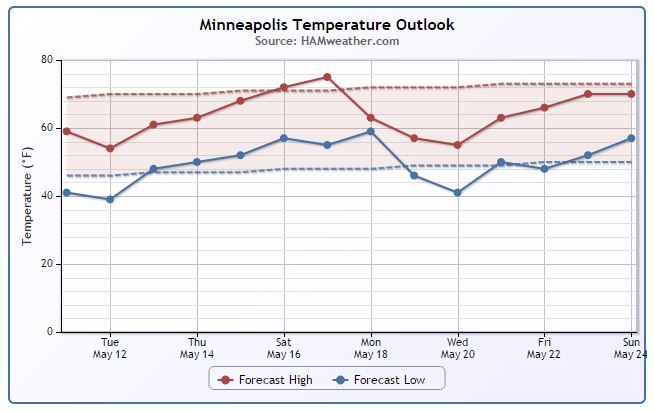
Minneapolis Temperature Trend
We've taken a bit of a hit in the temperature department since our latest storm system rolled into town. It looks like we stay chillier than average through much of the rest of the week, but a gradual warm up bring us back into the 70s this weekend! The extended forecast suggests yet again another cool blast next week before we warm up into Memorial Weekend.
______________________________________
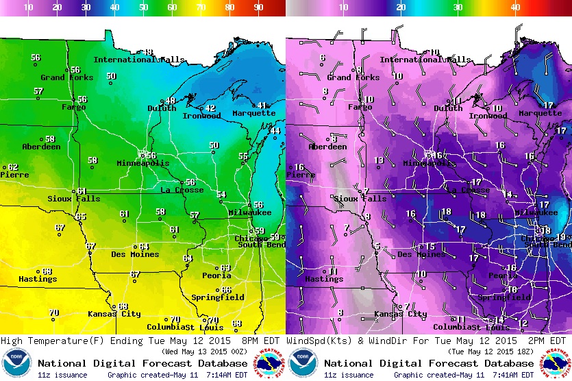
Tuesday Weather Outlook
The storm system that moved through the Upper Midwest Sunday and Monday will still be affecting the region Tuesday with cool, breezy and showery conditions. Temperatures across the northern part of the state will only warm into 40s and 50s, while temperatures across the southern part of the state may sneak up close to 60. Gusty NNW winds will make it feel more like April rather than May.
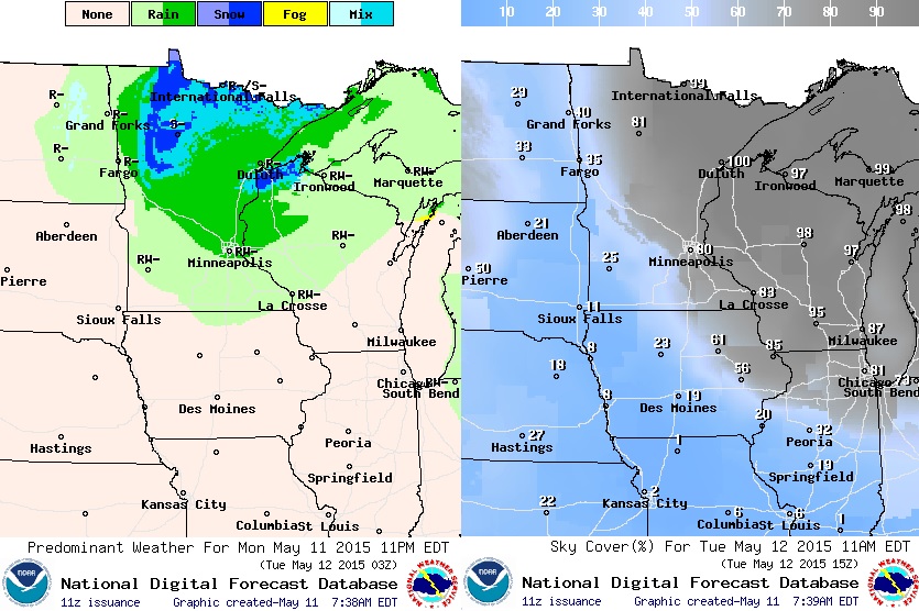
Tuesday Weather Outlook
Wrap around moisture will still be in place across the Upper Mississippi Valley on Tuesday. Scattered showers and mix precipitation will be found across the northern part of Minnesota and parts of northwestern Wisconsin, while temperatures a little farther south will be more conducive of just plain old rain.
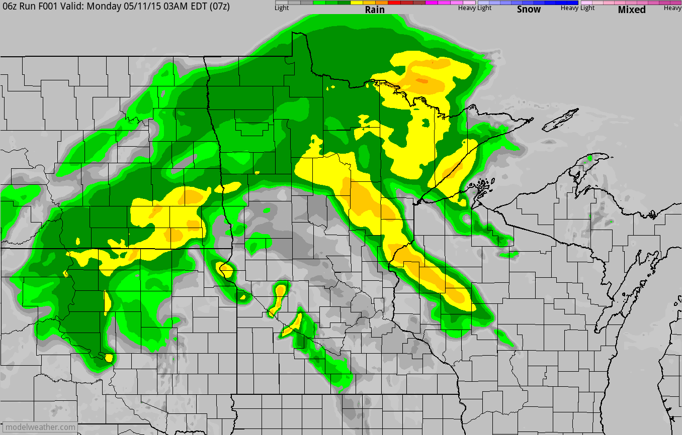
Simulated Radar
The simulated radar below shows the scattered showers and storms that pushed through the region Sunday night into early Monday morning, while areas of light rain and snow showers lingered across the Upper Mississippi Valley Monday/Monday night. A few light rain/snow showers may still be in place during Tuesday, but additional precipitation amounts should be light.
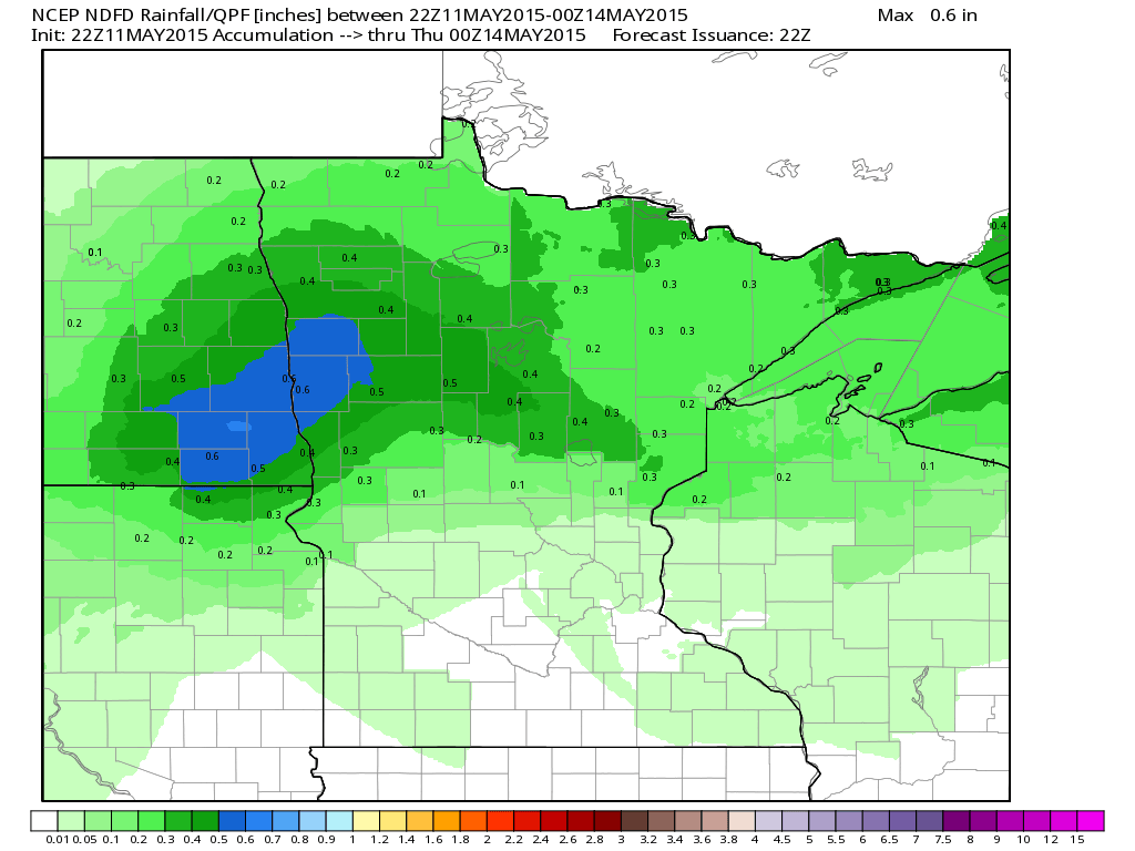
Precipitation Potential Through Midweek
While we say goodbye to our early week storm system, another batch of moisture is expected to push into the region PM Tuesday/Wednesday with some additional precipitation potential. Note that the heaviest amounts look to remain across the northern part of the state.
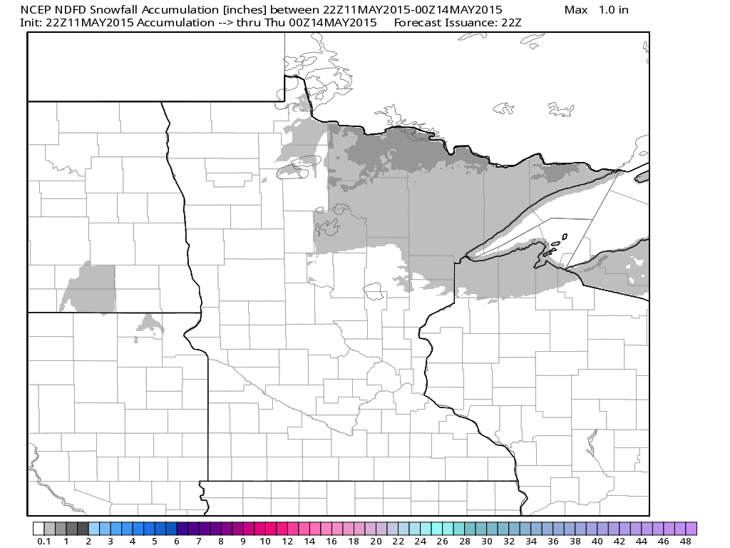
Snowfall Potential
Wrap around moisture will turn over into a little mixed precipitation and snow across northern Minnesota through Tuesday. While it doesn't appear to be much, areas closer to the international border could see some light/slushy snowfall accumulations through Tuesday.
______________________________________________________
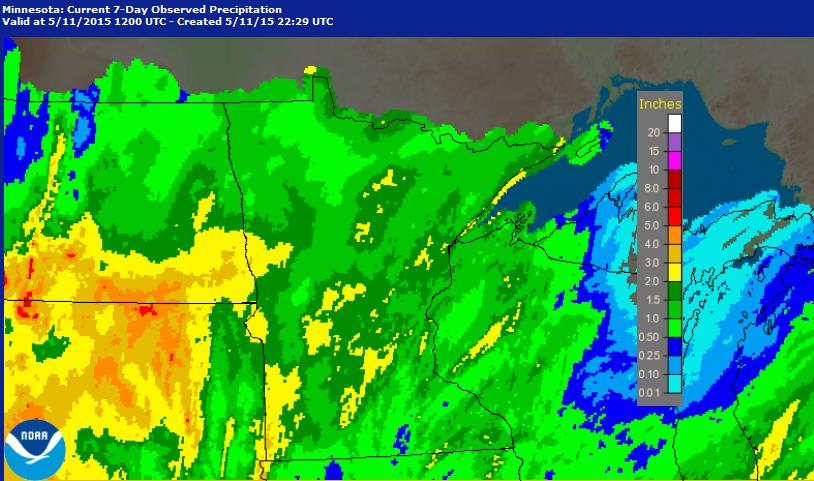
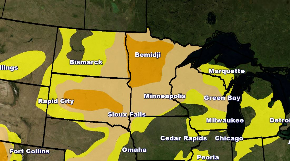
Precipitation Past 7 Days
The image below suggests radar estimated precipitation over the last 7 days. Note that several locations in Minnesota have seen 1" to nearly 3", while parts of the Dakotas have seen nearly 4" to 5" since last week! This is wonderful news considering many areas are still dealing with drought conditions.
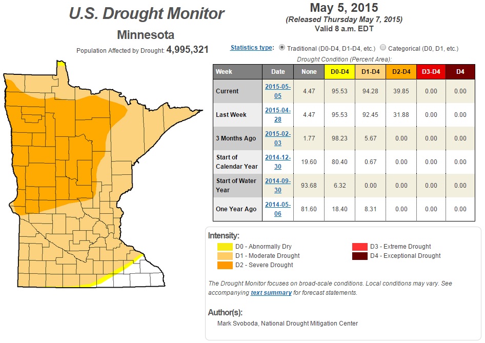
Drought Conditions
It'll be interesting to see how the recent moisture changes the current drought across the Midwest. The image below suggests what drought conditions were like as of last update (Thursday, May7th).
Minnesota Drought
According to the U.S. Drought Monitor, as of last week, ~94% of Minnesota was in a MODERATE drought, while nearly 40% of the state was in a severe drought. Again, it'll be interesting to see how the recent moisture will change the drought this week.
____________________________________________________
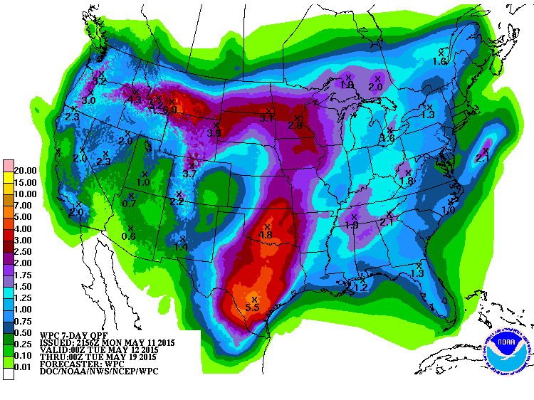
7 Day Precipitation Forecast
According to NOAA's HPC, the 7 day precipitation outlook suggests another surge of heavy moisture potential across the central part of the country. Through next Monday, extended forecasts suggest nearly 2" to 4" with isolated higher amounts. Also note the moisture potential across the Western U.S., including California!
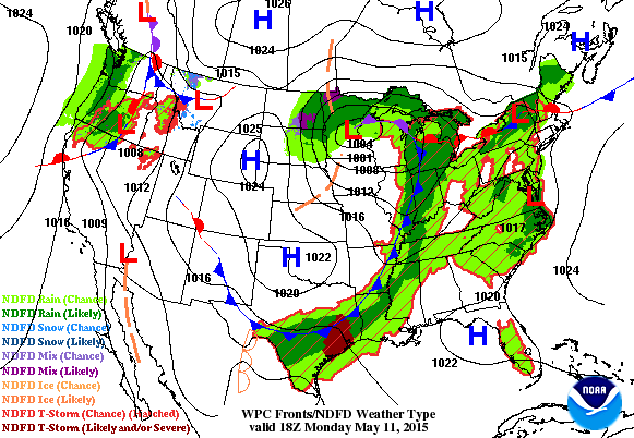
National Weather Outlook
The storm system that was responsible for such active weather across the country over the past several days will finally start moving out of the region by Tuesday. However, the trailing cold front will still keep shower and thunderstorm potential in place across the Gulf Coast States. Meanwhile, another storm system looks to take shape across the Western U.S. late this week and bring more shower and thunderstorm chances to the Plains Friday and Saturday.
____________________________________________________
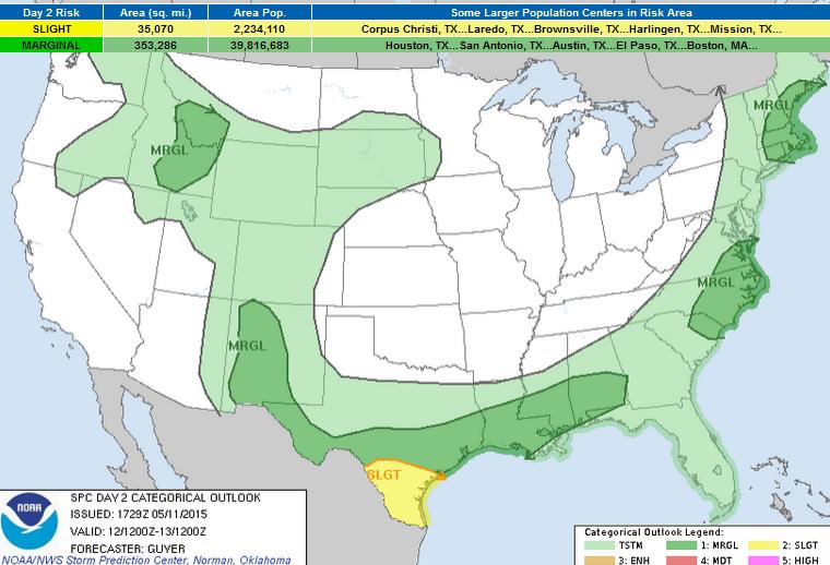
Severe Threat Tuesday
...SUMMARY...
ISOLATED TO SCATTERED STRONG TO SEVERE STORMS WILL BE POSSIBLE ON
TUESDAY IN AREAS SUCH AS SOUTH TEXAS AND THE ADJACENT GULF COAST
REGION...IN ADDITION TO PORTIONS OF NEW MEXICO AND THE EASTERN U.S.
...SYNOPSIS...
A PROGRESSIVE UPPER TROUGH/STRONG POLAR JET WILL SPREAD GENERALLY
EASTWARD OVER MUCH OF THE NORTHEAST STATES/NEW ENGLAND ON
TUESDAY...WHILE A COLD FRONT APPROACHES MUCH OF THE ATLANTIC
SEABOARD. AN UPPER LOW WILL PIVOT NORTHEASTWARD OVER THE PACIFIC
NORTHWEST...WHILE ADDITIONAL LOW-AMPLITUDE TROUGHS APPROACH CENTRAL
CA AS WELL AS SOUTHERN AZ/NM BY TUESDAY NIGHT.
...SOUTH TX TO CENTRAL GULF COAST STATES...
WILL MAINTAIN A CATEGORICAL SLIGHT RISK ACROSS SOUTH TX...BUT
CONFIDENCE IN FORECAST DETAILS ARE HINDERED BY FACTORS INCLUDING
EARLY DAY PRECIPITATION AND RELATED UNCERTAINTY FOR SUBSEQUENT
DESTABILIZATION DURING THE AFTERNOON NEAR/SOUTH OF AN ARCING FRONT.
VERTICAL SHEAR MAY ALSO TEND TO WEAKEN WITH TIME ACROSS MUCH OF
SOUTH TX...ALTHOUGH A SOMEWHAT GREATER COMBINATION OF VERTICAL
SHEAR/BUOYANCY MAY MATERIALIZE ALONG THE LOWER RIO GRANDE VICINITY
TUESDAY AFTERNOON/EVENING. AT LEAST SOME HAIL/WIND RISK WILL BE
POSSIBLE...PARTICULARLY DURING THE AFTERNOON/EVENING AS STORMS
REDEVELOP/INTENSIFY.
FARTHER EAST...STORMS MAY PERSIST/DEVELOP ACROSS ADDITIONAL PORTIONS
OF THE CENTRAL GULF COAST STATES NEAR THE SLOW-SOUTHEASTWARD-MOVING
FRONT. SUFFICIENT DESTABILIZATION MAY OCCUR BY AFTERNOON FOR A
LOCALIZED DAMAGING WIND/MARGINAL HAIL RISK FROM THE UPPER TX COAST
INTO SOUTHERN PORTIONS OF LA/MS/AL.
...NM...
LOWER-LEVEL MOISTURE WILL INCREASE/SPREAD WESTWARD THROUGH TUESDAY
VIA A POST-FRONTAL UPSLOPE REGIME. AS THE BOUNDARY LAYER DIURNALLY
WARMS...INCREASING MOISTURE/OROGRAPHIC LIFT IN CONJUNCTION WITH AN
APPROACHING UPPER JET EXIT REGION WILL CONTRIBUTE TO INCREASING
STORM COVERAGE/INTENSITY DURING THE AFTERNOON. MODEST VERTICAL SHEAR
AND STEEP LAPSE RATES/MODERATE BUOYANCY SHOULD ALLOW FOR SOME STRONG
TO SEVERE THUNDERSTORMS CAPABLE OF HAIL/WIND...PRIMARILY ACROSS
INTERIOR WESTERN/CENTRAL NM TUESDAY AFTERNOON/EARLY EVENING.
...PORTIONS OF NEW ENGLAND/SOUTHEAST NY...
ALTHOUGH SOME GUIDANCE VARIABILITY EXISTS REGARDING FRONTAL TIMING
AND PRE-FRONTAL MIXING/DRYING...THE FRONT-PRECEDING AIR MASS SHOULD
STEADILY WARM/DESTABILIZE BY TUESDAY AFTERNOON PARTICULARLY ACROSS
PORTIONS OF SOUTHERN/COASTAL NEW ENGLAND. SUFFICIENT
NEAR/PRE-FRONTAL CONVERGENCE COULD ALLOW SOME STRONGER
UPDRAFTS/THUNDERSTORMS TO DEVELOP. IF SUCH DEVELOPMENT OCCURS...A
VERY STRONG DEEP-LAYER WEST/SOUTHWESTERLY WIND FIELD /EFFECTIVE
SHEAR 50+ KT/ COULD CONTRIBUTE TO A FEW FAST-MOVING SEVERE
THUNDERSTORMS CAPABLE OF WIND DAMAGE. EVEN WITH SOME LINGERING
FORECAST UNCERTAINTIES...SCENARIO APPEARS TO WARRANT AN INTRODUCTION
OF MARGINAL-CALIBER SEVERE PROBABILITIES FOR TUESDAY AFTERNOON.
...SOUTHEAST VA/CAROLINAS...
A FEW STRONG TO SEVERE THUNDERSTORMS MAY DEVELOP ACROSS THE REGION
TUESDAY AFTERNOON IN VICINITY OF A COLD FRONT AND/OR PRE-FRONTAL
TROUGH WHERE THE AIR MASS WILL LIKELY HAVE BECOME MODERATELY
UNSTABLE ACROSS PIEDMONT/COASTAL PLAIN AREAS. LARGER-SCALE FORCING
FOR ASCENT WILL REMAIN MODEST...BUT SOMEWHAT STRENGTHENING MID-LEVEL
WESTERLIES COULD CONTRIBUTE TO SUFFICIENT /25-40 KT/ VERTICAL SHEAR
FOR SOME SEMI-ORGANIZED STORMS CAPABLE OF LOCALLY DAMAGING
WINDS/SOME HAIL TUESDAY AFTERNOON/EVENING.
...PORTIONS OF ID/SOUTHWEST MT...
ON THE EASTERN PERIPHERY OF THE PACIFIC NORTHWEST UPPER
LOW...SUFFICIENT FORCING FOR ASCENT/VERTICAL SHEAR MAY OVERSPREAD A
MODESTLY MOIST AIR MASS /PW VALUES GENERALLY AROUND 0.50 INCH/ TO
ALLOW FOR SOME STRONGER THUNDERSTORMS TUESDAY AFTERNOON. SPORADIC
STRONGER THUNDERSTORM WIND GUSTS AND/OR MARGINALLY-SEVERE HAIL MAY
BE POSSIBLE.
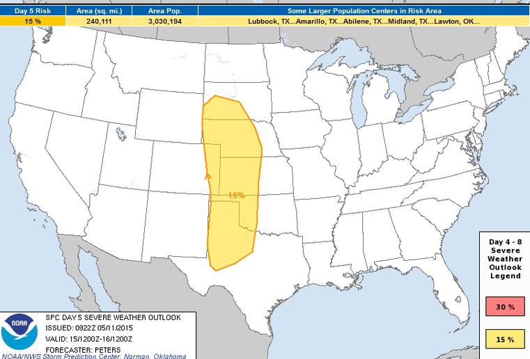
Severe Threat Friday
...DISCUSSION...
FOR FRI-MAY 15/...MODELS ARE IN GENERAL AGREEMENT WITH A
LARGE-SCALE TROUGH DEVELOPING ALONG THE U.S. WEST COAST DURING DAY 4
AND THEN MOVING INLAND FRIDAY ACROSS THE GREAT BASIN AND SWRN
STATES. ALTHOUGH THE 00Z GFS/ECMWF/UKMET DIFFER IN THE EWD MOVEMENT
OF THE CLOSED LOW...WITH THE GFS THE SLOWEST...HEIGHT FALLS ACROSS
THIS REGION WITH STRENGTHENING AND VERTICALLY VEERING WIND PROFILES
COUPLED WITH MOISTURE RETURN WILL RESULT IN A CAPE/SHEAR PARAMETER
SPACE MORE FAVORABLE FOR ORGANIZED SEVERE STORMS. INITIAL STORMS
WILL DEVELOP FRIDAY AFTERNOON ALONG A SHARPENING N-S DRY LINE
EXTENDING FROM THE CO/KS BORDER SWD INTO WEST TX...WITH ALL SEVERE
HAZARDS POSSIBLE. UPSCALE GROWTH INTO ONE OR MORE MCS/S WILL BE
POSSIBLE FRIDAY NIGHT ACROSS THE CENTRAL PLAINS AND WEST TX.
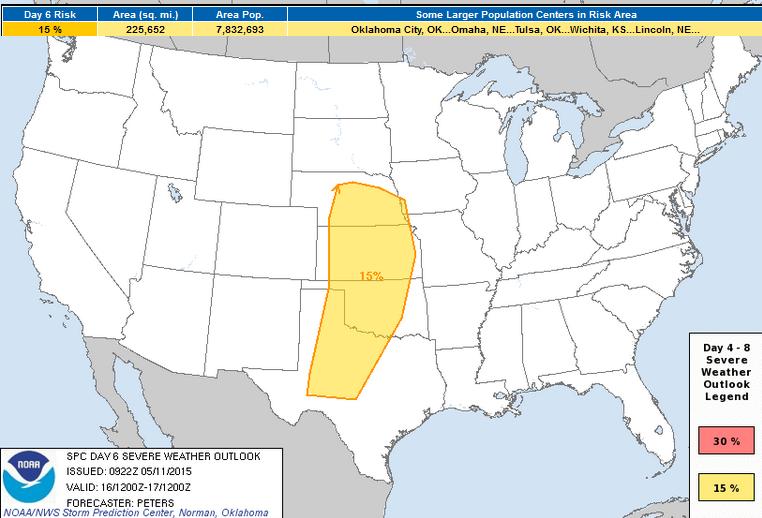
Severe Threat Saturday
FOR SAT-MAY 16/...ALTHOUGH THE 00Z GFS/ECMWF DIFFER IN THE
AMPLIFICATION AND DEGREE OF HEIGHT FALLS SPREADING ACROSS THE GREAT
PLAINS REGION ON SATURDAY...EACH MODEL SUGGESTS THE NOSE OF A 60-70
KT SWLY MIDLEVEL JET WILL EXTEND FROM THE SRN HIGH PLAINS TO THE
CENTRAL PLAINS THAT AFTERNOON. A STRENGTHENING SLY LLJ WILL PROVIDE
AN INFLUX OF RICH MOISTURE BENEATH A PLUME OF STEEPENING MIDLEVEL
LAPSE RATES. GIVEN THE DIFFERENCES IN THE UPPER PATTERN...THIS
OUTLOOK WILL INTRODUCE A 15 PERCENT PROBABILITY FOR ORGANIZED SEVERE
STORMS DEVELOPING SATURDAY AFTERNOON AND CONTINUING INTO THE EVENING
WITH ALL SEVERE HAZARDS LIKELY. LATER OUTLOOKS MAY REQUIRE AN
INCREASE IN SEVERE PROBABILITIES.
_______________________________________
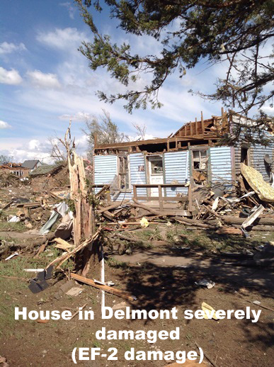
EF-2 Tornado in Delmont, SD
"An EF-2 tornado hit Delmont, South Dakota on Mother's Day morning around 10:45 am CDT. The tornado developed 3 miles east of Wagner, South Dakota around 10:21 am CDT and moved north-northeast at almost 30 mph. The tornado remained over open country across Charles Mix County only damaging some trees. Once the tornado moved into Douglas County, it hit a farm 3 miles south of Delmont doing EF-2 damage. Three other farms were hit by the tornado south of Delmont which also produced EF-2 damage. The tornado moved into Delmont around 10:45 damaging several homes, a church and the destroying the new fire station. As the tornado moved north of Delmont, it began to weaken. The tornado lifted approximately 3.5 miles north of Delmont around 10:52 am."
See more from the NWS Sioux Falls, SD HERE:
(Image below courtesy: NWS Sioux Falls, SD)
Recent Uptick in Tornadoes
Take a look at all the tornado reports across the central part of the country from Wednesday, May 6th to Monday, May 11th. According to NOAA's SPC, there were nearly 140 PRELIMINARY tornado reports during that time frame. Note that both May 9th and May 6th were the two top tornado days of 2015 with 50 and 48 tornado reports respectively.
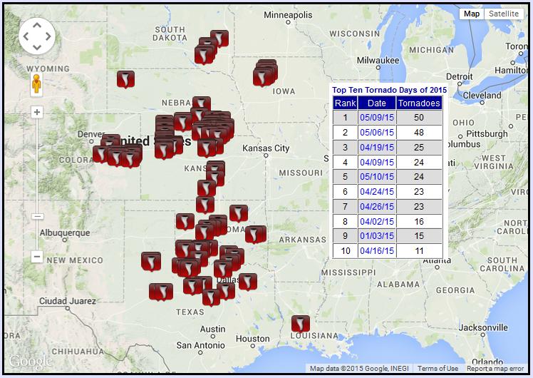
2015 PRELIMINARY Tornado Count
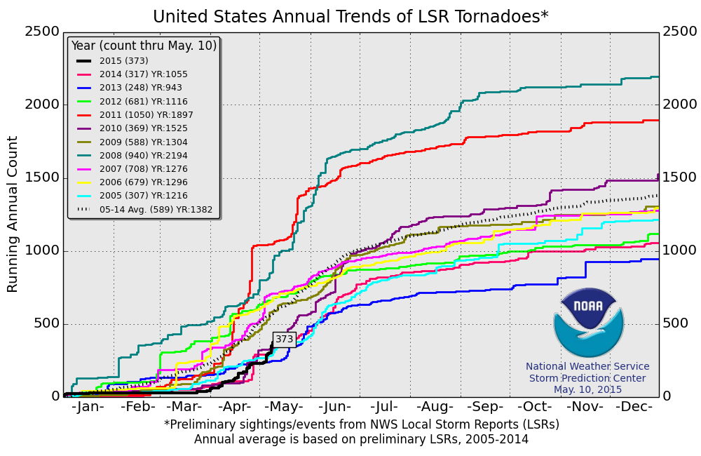
According to NOAA's SPC, the 2015 preliminary tornado count through May 10th is 373. Despite the recent uptick in the tornado count, we're still below the 2005-2014 average of 589 through that date. The red line below shows the tornado count in 2011, which by May 10th, there had been more than 1,000 tornado reports!
__________________________________________
Thanks for checking in and have a great rest of your week. Don't forget to follow me on Twitter @TNelsonWX

No comments:
Post a Comment