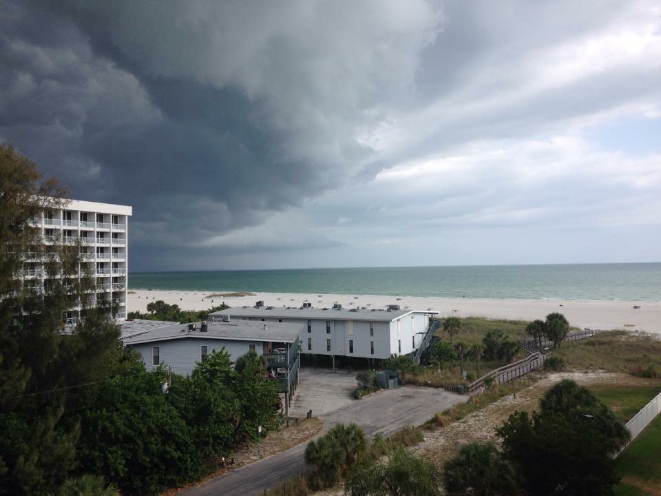
Thanks to my good friend Stephanie Chanaka Johnson for the picture below out of St. Petersburg, FL. Hope the weather is cooperating and you guys are having fun! I'm jealous!!
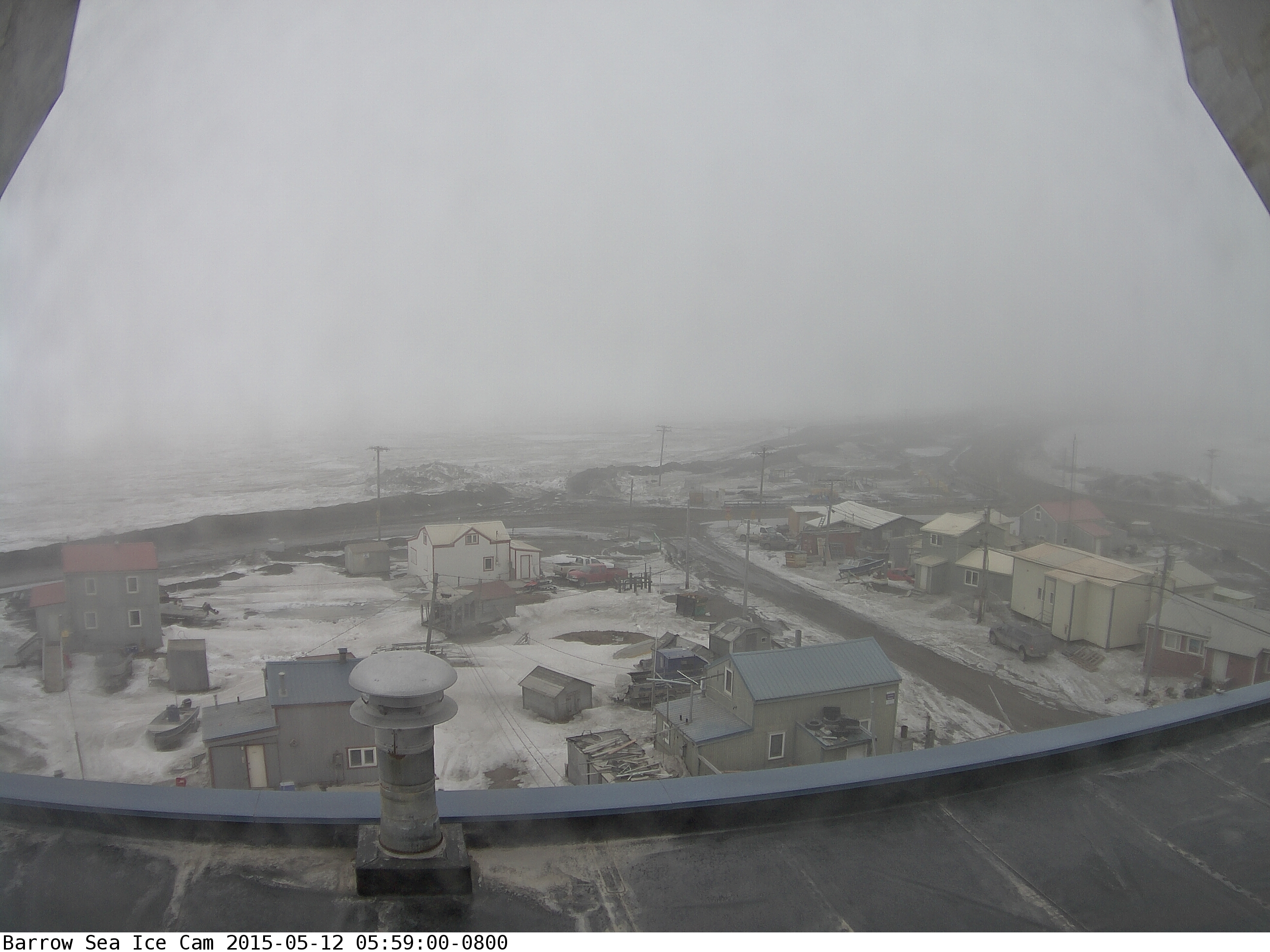
24 Hour Sunlight in Barrow, AK
Take a look at the image below from Barrow, AK where the sun came up at 2:37am Monday and won't set again until early August!
(Image courtesy: University of Alaska Fairbanks)
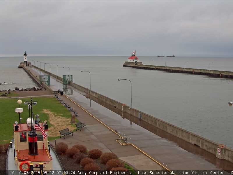
Tuesday Morning Snow in Duluth
This was the cloudy/soggy view from Duluth, MN early Tuesday morning after a few wet snow flakes were reported over the hill. While they didn't see any measurable stuff, it's important to note that Duluth averages around a half an inch of snow in May!
Denting the Drought
By Todd Nelson
It's hard to imagine there being an ongoing drought situation with as much green as I see right now, but as of last week, the U.S. Drought Monitor had nearly 94 percent of the state in a moderate drought and nearly 40 percent of the state in a severe drought. Since then, radar estimates over the last 7 days have suggested that nearly 1 inch of rain has fallen across much of the state, while a few locations have seen as much as 2 to 3 inches. With that said, I am interested to see how the drought will change with the new update, which gets released tomorrow. Whether or not we see any significant changes, the next 7 days are favorable for more drought denting as an additional 1 to 2 inches of rain may be possible through early next week!
Up until recently, there has been a bit of a national tornado drought this year as well. The 2005-2014 average suggests there should have been 600 tornadoes through May 11th, but there have only been 384. Keep in mind that 158 of those have happened this month! Nationally, May typically sees 276 tornadoes, 5 of which are in Minnesota. We had 3 May tornadoes last year and haven't had a Minnesota tornado since September 19th.
____________________________________
TUESDAY NIGHT: Nothing rough. Low: 42. Winds: NW turning ESE 5-10
WEDNESDAY: Mix of clouds and sun. Showers up north. High: 63. Winds: ESE 10-20
WEDNESDAY NIGHT: more clouds and breezy. Low: 50. Winds: SE 15.
THURSDAY: Rain. Lots of PM puddles. High: 59. Winds: SE 15
FRIDAY: Soggy start. Drier by afternoon. Wake-up: 49. High: 66.
SATURDAY: Breezy and mild. Late day T-shower. Wake-up: 54. High: 74.
SUNDAY: Warm with a few thundery downpours. Wake-up: 61. High: 76.
MONDAY: Lingering showers. Isolated storm. Wake-up: 54. High: 72.
TUESDAY: Cool and breezy. Spits of rain. Wake-up: 52. High: 64.
_______________________________________
This Day in Weather History
May 13th
1872: Hailstorm in Sibley County. Hail reported the size of pigeon eggs. Lightning burned down a barn near Sibley and killed a horse tied up inside.
________________________________________
Average High/Low for Minneapolis
May 13th
Average High: 69F (Record: 92F set in 2007)
Average Low: 48F (29F set in 1953)
________________________________________
Sunrise/Sunset Times for Minneapolis
May 13th
Sunrise: 5:47am
Sunset: 8:32pm
_________________________________________
Moon Phase for May 13th
2.8 Days After Last Quarter
___________________________________________
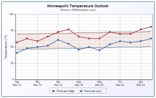
Minneapolis Temperature Trend
Coolish weather continues over the next few days, but we're heading int the right direction. It appears that near to above average levels return by the end of the week/weekend ahead. However, note the slight cool down into early next week. This will be in the wake of another storm system that will bring more rain and thunder to the region during the late week time frame. We're also starting to get a little data for the upcoming Memorial Weekend and at this point, temperatures look to be pretty seasonable... stay tuned!
Wednesday Weather Outlook
Temperatures on Wednesday still look chilly for May across the northern part of the state. Highs there will only warm into the 50s, while a few locations across the southwestern part of the state could warm into lowers 70s! However, wind speeds will once again be a bit on the gusty side, especially in the western part of the state.
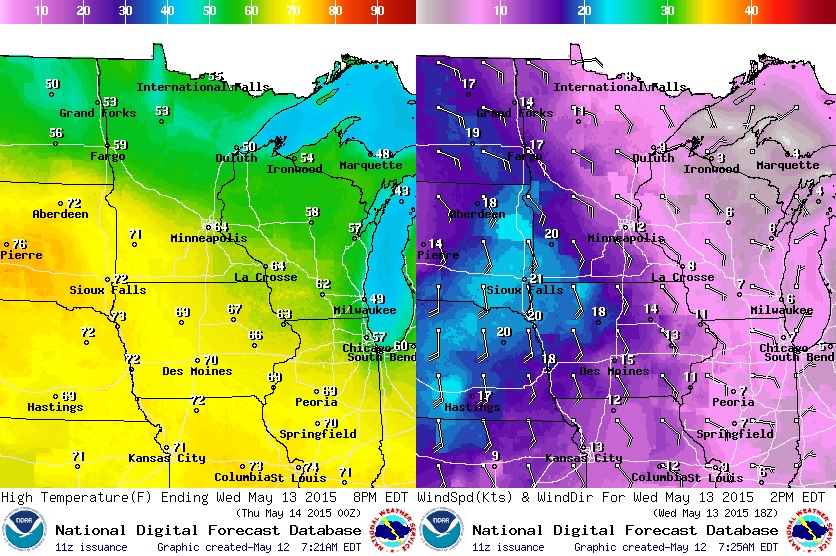
Wednesday Weather Outlook
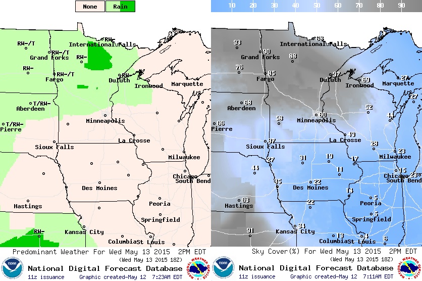
Areas of rain and possibly even a few rumbles of thunder will be possible across the northern half of the state on Wednesday. While light steadier rains will be found across northern Minnesota, parts of Minnesota will see a little sunshine and warmer temperatures!
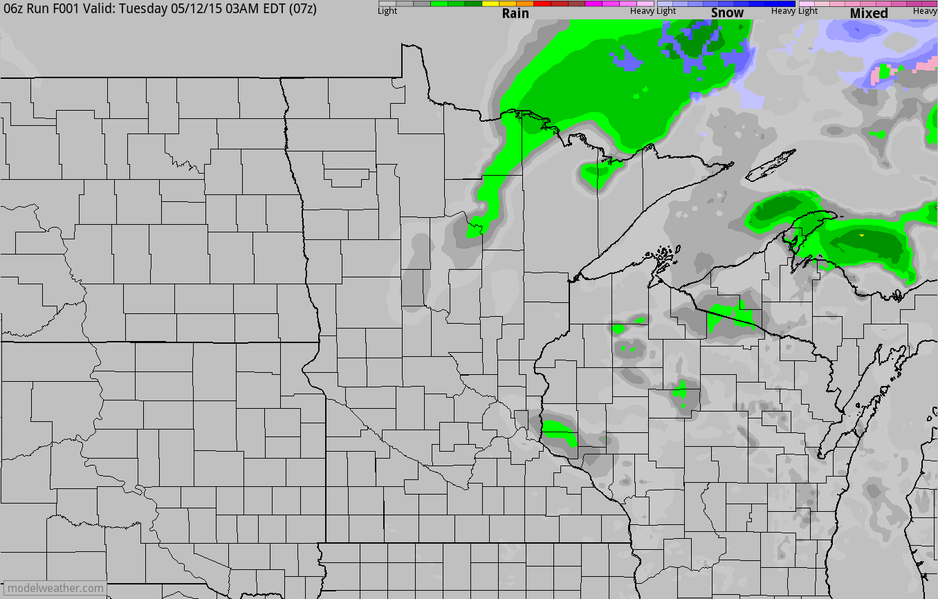
Simulated Radar
In the simulated radar loop below, you can see our cool, breezy and showery weather from the early week time frame sliding east, while another batch of moisture moves into the region PM Tuesday and Wednesday.
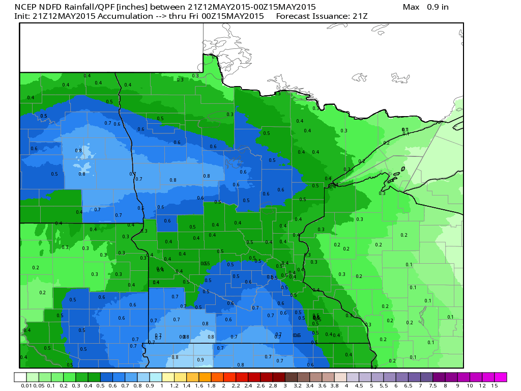
Rainfall Potential
Another surge of heavier moisture looks to push into the region over the next couple of days. According to the NOAA's NCEP, the rainfall forecast suggests some spots could see an additional 0.5" to 1.0" through PM Thursday!
____________________________________________
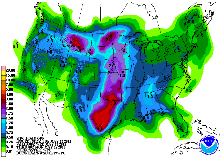
7 Day Precipitation Outlook
WOW! The 7 day precipitation outlook from NOAA's HPC still looks pretty impressive. In fact, as much as 2" to 5" may be possible across parts of the Central U.S. through early next week. It'll be interesting to see how the U.S. Drought Monitor update looks over the next couple of weeks. I am expecting at least some improvements in the Central U.S. with all the moisture we've been seeing and all the moisture that is still in the forecast.
_____________________________________
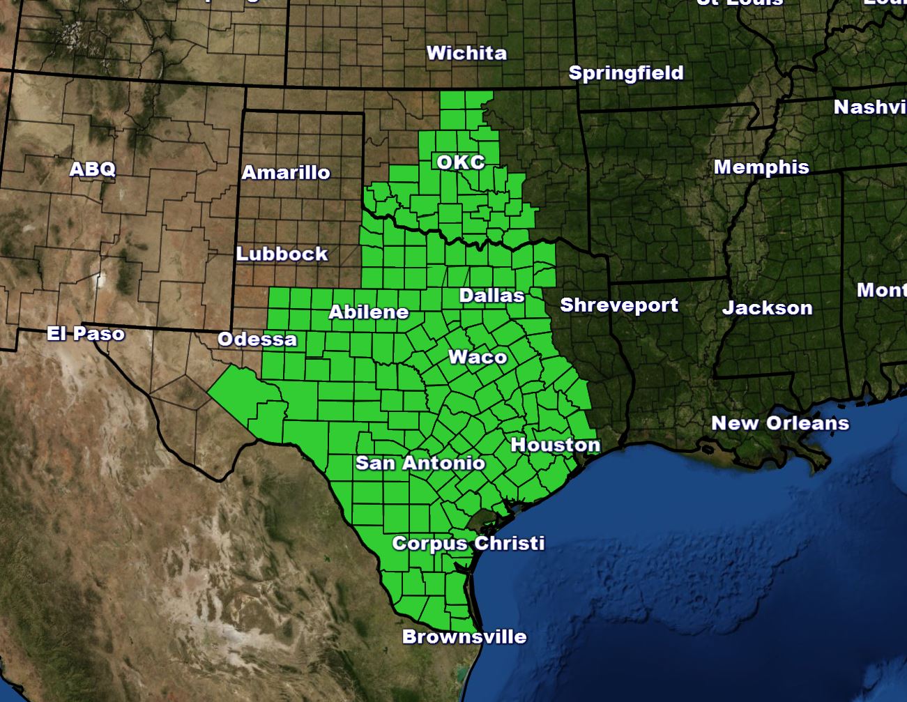
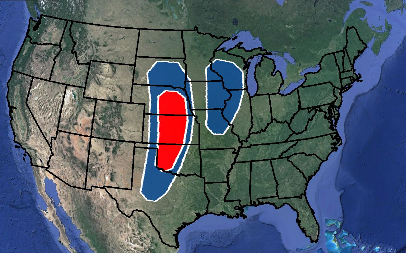
Flash Flood Watch
Areas of the Central and Southern Plains have been recently inundated with heavy rains and with additional heavy rain potentially on the way, Flash Flood Watches have been issued through Wednesday in the areas shaded in green below.
__________________________________________
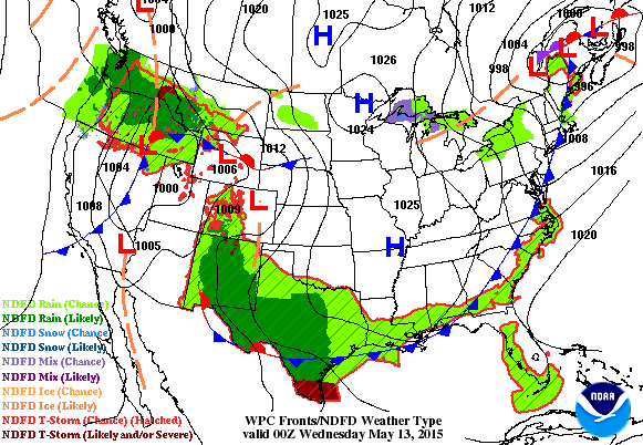
National Weather Outlook
Weather conditions were a little quieter across country on Tuesday, but note the next area of low pressure moving north through the Central U.S. over the next couple of days. While severe weather chances remain low with this particular storm system, rainfall tallies will be on the rise. Severe weather chances look to be much greater later this week and weekend.
__________________________________________
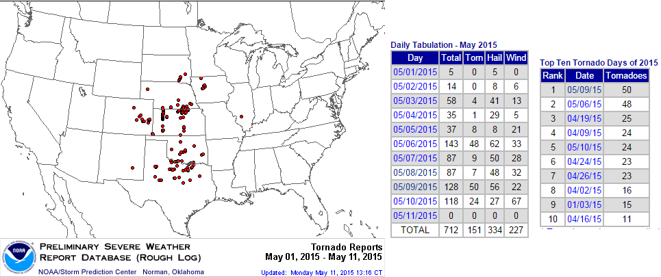
2015 May Tornado Reports So Far
According to NOAA's SPC, there have been nearly 150 PRELIMINARY tornado reports so far this May, most of which have occurred in the central part of the country. Interestingly, the top 2 tornado days of 2015 so far have occurred in May (May 9th: 50 reports & May 6th: 48 reports).
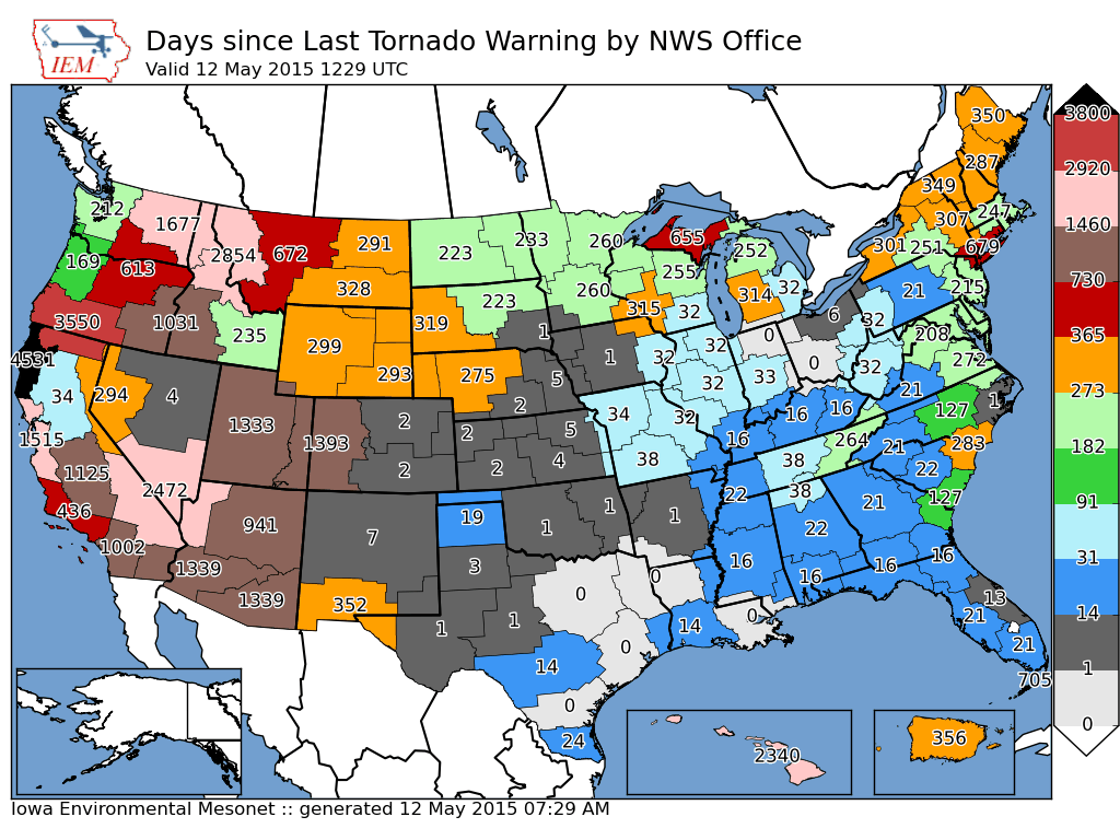
Days Since Last Tornado Warning
Here's an interesting graphic that shows how many days it has been since particular National Weather Service offices have issued a tornado warning. Note that as of May 12th, several offices in the central part of the country have issued tornado warnings within the last several days. Interestingly, the last time the National Weather Service in the Twin Cities has issued a tornado warning for their county warning area was 260 days ago! The last time Minnesota had a tornado was back on September 19th, 2014.
Severe Threat Ramps Up Friday
...DISCUSSION... MODEL CONSENSUS IS THAT A LARGE UPPER TROUGH THAT IS EXPECTED TO EVOLVE OVER THE WRN U.S. FRIDAY WILL MOVE INTO THE CNTRL AND SRN PLAINS SATURDAY AND CONTINUE NEWD INTO THE UPPER MS VALLEY AND GREAT LAKES AREA SUNDAY.
FRIDAY/...BROAD...MOIST WARM SECTOR WILL EXPAND THROUGH THE PLAINS WITH AN AXIS OF STRONG INSTABILITY LIKELY TO EVOLVE FROM THE SRN THROUGH CNTRL PLAINS AS STEEP LAPSE RATES ADVECT EWD ABOVE THE MOIST AXIS. PRIMARY UPPER TROUGH WILL REMAIN WEST OF A DRYLINE THAT WILL EXTEND FROM THE SRN THROUGH CNTRL HIGH PLAINS. ISOLATED STORMS ARE EXPECTED TO DEVELOP ALONG DRYLINE FROM PORTIONS OF WRN TX NWD THROUGH NEB BY LATE AFTERNOON AS CONVECTIVE INHIBITION WEAKENS. INITIALLY WEAK WINDS ALOFT AND VERTICAL SHEAR WILL UNDERGO AT LEAST A MODEST INCREASE AS THE TROUGH CONTINUES SLOWLY EWD...BECOMING SUPPORTIVE OF SUPERCELLS BY LATE DAY. ACTIVITY SHOULD DIMINISH BY MID-EVENING WITH LOSS OF DIABATIC WARMING.

Severe Threat Saturday and Sunday
SATURDAY/...A RESERVOIR OF MODERATE-STRONG INSTABILITY WILL LIKELY DEVELOP FROM THE SRN THROUGH CNTRL PLAINS. POTENTIAL WILL EXIST FOR NUMEROUS THUNDERSTORMS TO INITIATE DURING THE AFTERNOON AS ZONE OF DEEPER FORCING ACCOMPANYING THE UPPER TROUGH AND ATTENDANT PACIFIC FRONT INTERACTS WITH THE MOIST AND UNSTABLE WARM SECTOR. THOUGH MERIDIONAL IN CHARACTER...WIND PROFILES WILL STRENGTHEN WITH DEEP SHEAR BECOMING SUPPORTIVE OF ORGANIZED SEVERE STORMS INCLUDING SUPERCELLS AND BOWING LINE SEGMENTS.
SUNDAY/...STRONGER WINDS ALOFT ACCOMPANYING THE UPPER TROUGH WILL SHIFT INTO THE UPPER MS VALLEY REGION WHERE A MOIST WARM SECTOR WILL RESIDE. PRIMARY COMPLICATING FACTOR FOR DAY 6 WILL BE THE POTENTIAL FOR ONGOING STORMS WHICH MIGHT LIMIT INSTABILITY IN PORTIONS OF THIS REGION. NEVERTHELESS...THE SHEAR/INSTABILITY PARAMETER SPACE WILL BE SUFFICIENT FOR AT LEAST SOME RISK FOR SEVERE STORMS WHERE SUFFICIENT BOUNDARY LAYER WARMING OCCURS DURING THE AFTERNOON.
___________________________________________
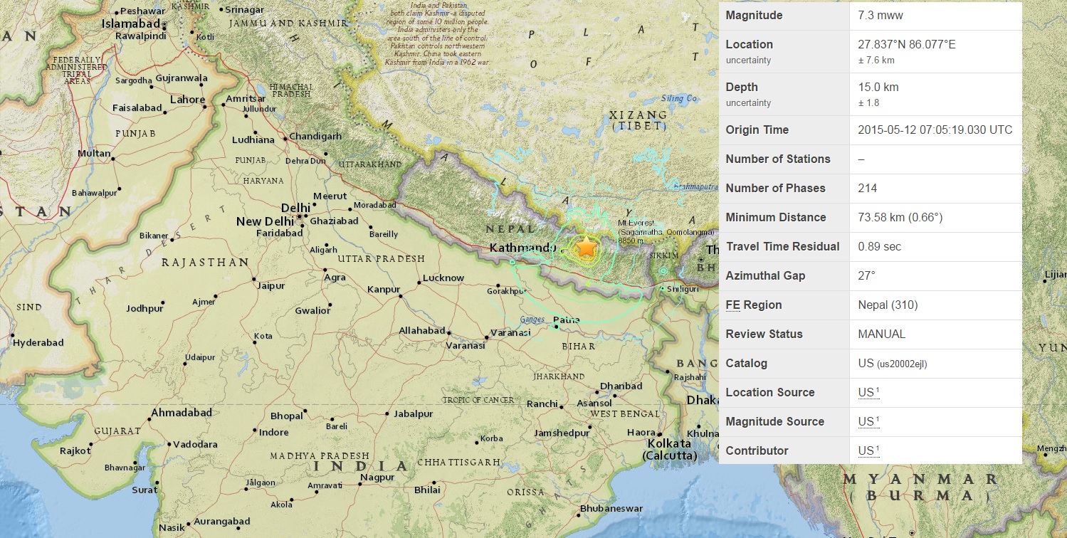
Another Large Earthquake in Nepal: 7.3 Magnitude
"The May 12, 2015 M 7.3 Nepal earthquake (SE of Zham, China) occurred as the result of thrust faulting on or near the decollément associated with the Main Himalayan Thrust, which defines the interface between the underthrusting India plate and the overriding Eurasia plate to the north. At the location of this earthquake, approximately 80 km to the east-northeast of the Nepalese capital of Kathmandu, the India plate is converging with Eurasia at a rate of 45 mm/yr towards the north-northeast – a fraction of which (~18 mm/yr) is driving the uplift of the Himalayan mountain range. The May 12, 2015 event is the largest aftershock to date of the M 7.8 April 25, 2015 Nepal earthquake – known as the Gorkha earthquake - which was located 150 km to the west, and which ruptured much of the decollément between these two earthquakes.
While commonly plotted as points on maps, earthquakes of this size are more appropriately described as slip over a larger fault area. Events of the size of the May 12, 2015 earthquake are typically about 55x30 km in size (length x width). The April 25, 2015 M 7.8 mainshock had approximate dimensions of ~120x80 km, directed from its hypocenter eastwards, and towards Kathmandu. The May 12, 2015 earthquake is located just beyond the eastern end of that rupture.
The boundary region of the India and Eurasia plates has a history of large and great earthquakes. Prior to April 25, four events of M6 or larger had occurred within 250 km of this area over the past century. One, a M 6.9 earthquake in August 1988, 140 km to the south-southeast of the May 12 event, caused close to 1500 fatalities. The largest, an M 8.0 event known as the 1934 Nepal-Bihar earthquake, ruptured a large section of the fault to the south of this May 2015 event, and east of the April 2015 mainshock, in a similar location to the 1988 earthquake. It severely damaged Kathmandu, and is thought to have caused around 10,600 fatalities. Prior to the 20th century, a large earthquake in 1833 is thought to have ruptured a similar area as the April 25, 2015 event. To date, there have been close to 100 M3+ aftershocks of the Gorkha earthquake. In the first two hours after the May 12 event, six further aftershocks have occurred, to the southwest-to-southeast of that earthquake."
See more from the USGS HERE:
______________________________
Thanks for checking in and have a great rest of your week! Don't forget to follow me on Twitter @TNelsonWX

No comments:
Post a Comment