
Spoiled so quickly
By Todd Nelson
As Minnesotans, we certainly have a right to complain about the weather. Listen, 7 months out of the year typically have snow in Minnesota and while some would rather have winter all year round, others can't wait for the snow to melt!
Summers are very short close to the international border, so we tend to make the most of each warm, sunny day. It's tough when Mother Nature teases us with early Summer weather, then takes it away with one sharp cold front. Unfortunately, I tend to hear more about it when the weather sours. Unpleasant emails tend to filter in a little more wondering why I can't do something about it. Hey, I get it! It's easy to pick on the meteorologist. We make good punching bags, especially when the weather is bad.
Today will be drier than yesterday, but temps take a hit. 50s and 60s look to be more commonplace through much of next week with a few 40s possible up north. In fact, extended forecasts suggest a few flakes up north by Tuesday morning!
Good news, we stay dry today and for the fishing opener tomorrow. Bad news, Mom's Day looks a little wet and windy as our next storm system moves in and brings us some much needed rain.
___________________________________
THURSDAY NIGHT: Spotty showers and storms possible early. Low: 54. Winds: SSW 10-15.
FRIDAY: Somewhat soggy start. Cooler with more PM sun. High: 65. Winds: NNW 10-15
FRIDAY NIGHT: Dry and quiet. Low: 48. Winds: N 5-10
SATURDAY: Looking dry for the fishing opener. Better chop by afternoon. High: 65. Winds: NNE 10-15
SUNDAY:Breezy Mother's Day. Scattered showers and storms develop. Wake-up: 48. High: 59.
MONDAY: More wind. Feels like early with with lingering showers. Wake-up: 46. High: 58.
TUESDAY: Spits of rain. Mix up north? Wake-up: 40. High: 55.
WEDNESDAY: Getting better. Still cool for May. Wake-up: 39. High: 61.
THURSDAY: Clouds thicken. Getting warmer. Wake-up: 43. High: 64.
________________________________
This Day in Weather History
May 8th
1924: Snowstorm brings 4 inches to parts of Minnesota. Minneapolis sees a half inch of snow with St. Paul picking up an inch. 50 mph winds accompanied the snow and heavy coats were brought back out of the closet.
_________________________________
Average High/Low for Minneapolis
May 8th
Average High: 67F (Record: 90F set in 1874)
Average Low: 47F (Record: 28F set in 1960)
__________________________________
Sunrise/Sunset Times for Minneapolis
May 8th
Sunrise: 5:54am
Sunset: 8:25pm
__________________________________
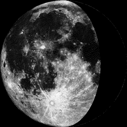
Moon Phase for May 8th at Midnight
2.2 Days Before Last Quarter
____________________________________
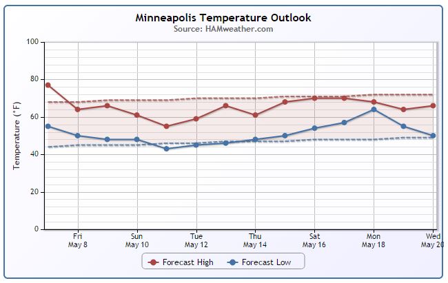
Minneapolis Temperature Trend
Temperatures in Minneapolis were running nearly 8° above average through the first 6 days of May. We are expecting temperatures to take a bit of a dip over the next few days. We will be a little closer to average Friday and Saturday, but a bigger cool down is expected Mother's Day through much of next week. Extended forecasts suggests temperatures getting back to nearly normal by next weekend.
________________________________
Friday Weather Outlook
After a fairly soggy Thursday, weather conditions will improve through the day Friday. It won't be quite as wet, but it will be cooler as northwesterly winds pick up on the backside of the departing storm system. Highs in the Twin Cities will only warm into the low/mid 60s, which will be a little cooler than average for early May.
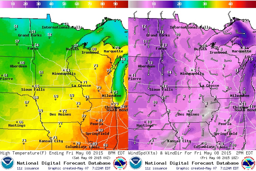
Friday Weather Outlook
Lingering clouds and spotty showers will be in place early Friday, but clouds will begin to decrease as we head through the day.
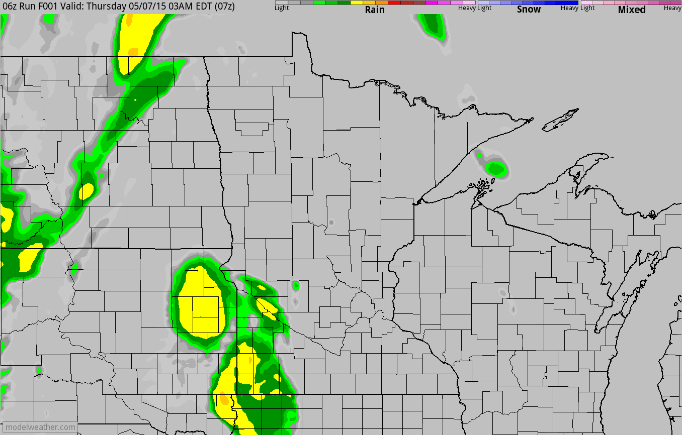
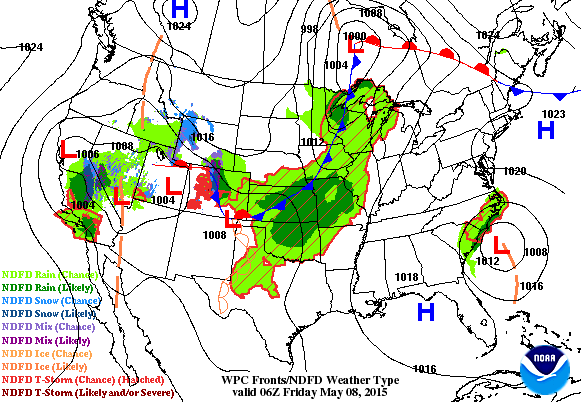
Simulated Radar
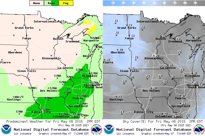
The wettest day of the week for most of us was Thursday. Weather conditions look mostly dry across the region Friday and for the Fishing Opener Saturday. However, Mother's day looks little breezy and perhaps a little wet late in the day across southern MN.
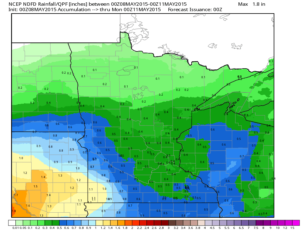
Rainfall Potential Through Saturday
The image below suggests the precipitation potential from PM Thursday to PM Sunday. After some heavy downpours on Thursday, things should stay mostly dry on Friday and Saturday before more moisture moves in from the southwest Sunday.
____________________________________________________________
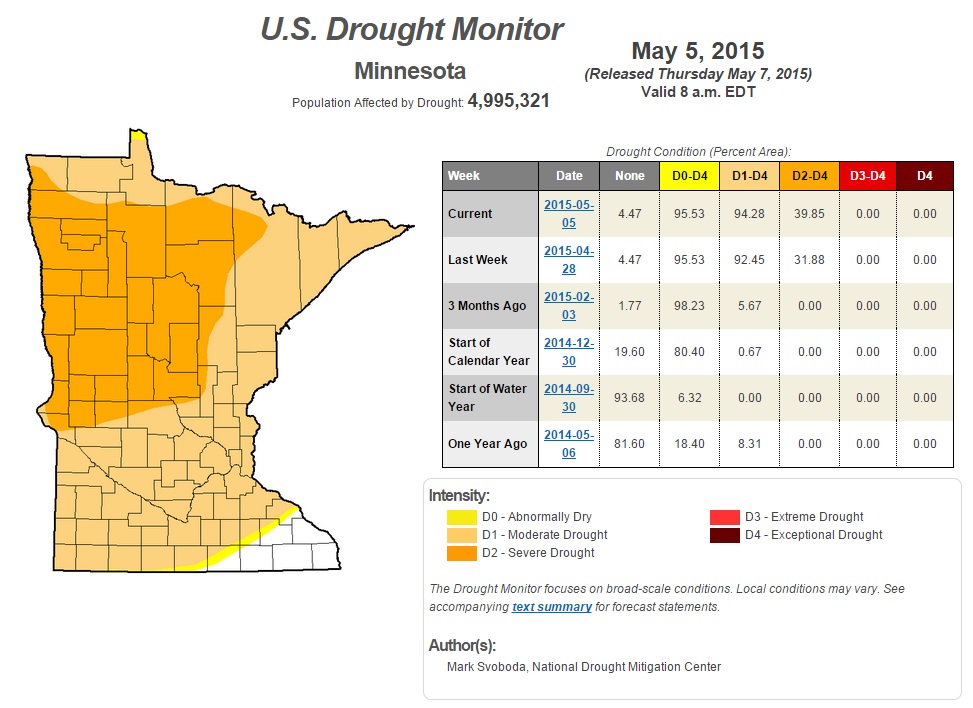
Minnesota Drought Update
The newest drought update was released Thursday by the U.S. Drought Monitor. Unfortunately, it shows that drought conditions have worsened since last week. MODERATE drought has increased from nearly 92.5% to nearly 94%, while the SEVERE drought has increased from nearly 32% to nearly 40%. Recent rains have yet to be incorporated into this update, so hopefully with the additional moisture expected over the next 5 days, we'll see an improvement by next week.
____________________________________________________________
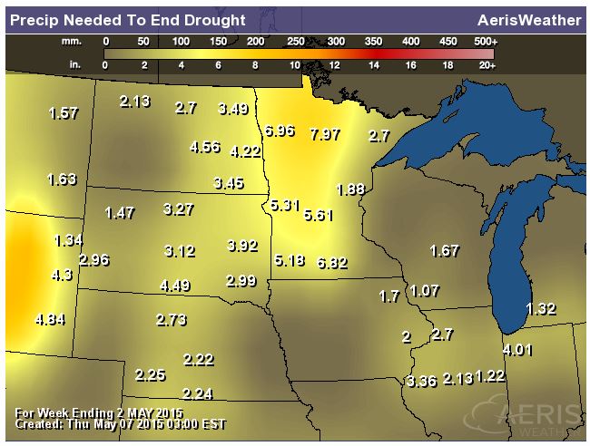
Rain Needed to End Drought
As of Thursday morning, some locations across western Minnesota would have needed nearly 6" to 7" or more of rain to end the drought. While we mostly likely won't see that out of one or two storms, we certainly could use a few good soakings to help dent the drought a bit.
___________________________________________________________
National Weather Outlook
As one area of low pressure lifts north towards the Hudson Bay, another large area of low pressure takes shape over the Rockies. This next area of low pressure will slowly move east and bringing chances of snow through the high elevations, while also kicking out several days of strong to severe thunderstorm potential across the Central U.S.. Hail, high winds, tornadoes and flooding rains will be all be possible over the next several days. Meanwhile, the National Hurricane Center continues to monitor an area of low pressure just south of the Carolinas.
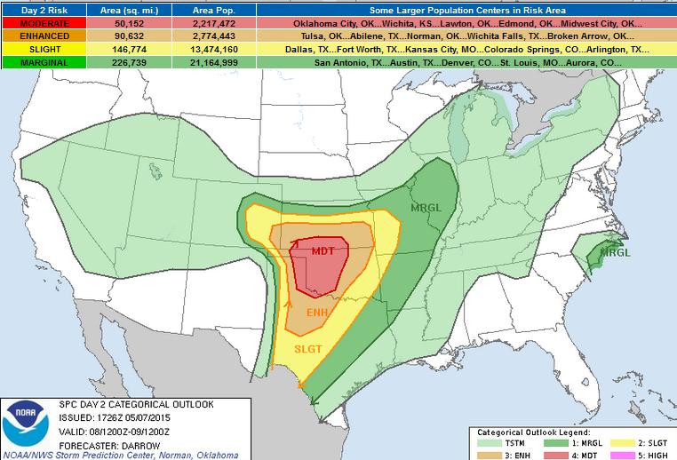
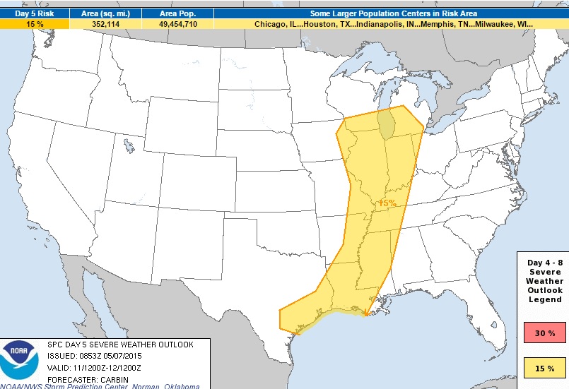
Severe Threat Friday
...SUMMARY...
SEVERE THUNDERSTORMS WILL DEVELOP ACROSS THE SOUTHERN AND CENTRAL
GREAT PLAINS. VERY LARGE HAIL...DAMAGING WINDS...AND TORNADOES ARE
EXPECTED...ESPECIALLY ACROSS WESTERN OKLAHOMA.
...SOUTHERN/CENTRAL GREAT PLAINS...
LARGE-SCALE HEIGHT FALLS WILL SPREAD INTO THE DESERT SOUTHWEST
DURING THE DAY2 PERIOD AS STRONG UPPER LOW TRANSLATES INTO THE
4-CORNERS REGION LATE. DIFLUENT HIGH-LEVEL FLOW WILL SPREAD ACROSS
THE SRN/CNTRL PLAINS AHEAD OF THIS FEATURE WITH SUBSTANTIAL FLOW
EXPECTED TO OVERSPREAD A PRONOUNCED DRY LINE DURING PEAK HEATING.
STRONG SHEAR AND FAVORABLE HIGH-LEVEL VENTING SHOULD RESULT IN A
CONCENTRATED CORRIDOR OF SEVERE THUNDERSTORMS...ESPECIALLY ACROSS
WRN OK.
BOTH THE GFS AND NAM SUGGEST A WEAK MID-LEVEL SHORT-WAVE TROUGH WILL
EJECT ACROSS THE SRN HIGH PLAINS AFTER 18Z...TRANSLATING INTO WRN OK
BY 09/00Z. THIS FEATURE IS EXPECTED TO AID CONVECTIVE DEVELOPMENT
ALONG DRY LINE BY EARLY-MID AFTERNOON ACROSS THE HIGH
PLAINS...SPREADING/DEVELOPING EWD TOWARD THE I-35 CORRIDOR BY LATE
AFTERNOON. SHEAR PROFILES FAVOR SUPERCELLS AND BOUNDARY-LAYER
MOISTURE...ABSENT DAY1 CONVECTIVE DISRUPTION...SHOULD EASILY ADVANCE
NWD TOWARD SYNOPTIC BOUNDARY THAT SHOULD ORIENT ITSELF IN AN E-W
FASHION ACROSS SRN KS/SERN CO. IF MOISTURE/INSTABILITY RETURN TO
THE SYNOPTIC BOUNDARY...AS SUGGESTED BY LATEST NAM...ROBUST SEVERE
THUNDERSTORMS WILL DEVELOP ALONG A FAVORABLY SHEARED BOUNDARY THAT
COULD ENHANCE TORNADO POTENTIAL WITH ANY SUPERCELLS. EVEN
SO...DISCRETE WARM SECTOR SUPERCELLS ARE EXPECTED TO DEVELOP ACROSS
THE AFOREMENTIONED REGION OF NWRN TX...NWD TO THE SYNOPTIC FRONT
WITHIN AN ENVIRONMENT SEEMINGLY FAVORABLE FOR VERY LARGE
HAIL...TORNADOES...AND DAMAGING WINDS. FORECAST NAM SOUNDINGS
EXHIBIT PROFILES CHARACTERISTIC OF STORMS CAPABLE OF PRODUCING HAIL
IN EXCESS OF 2 INCHES AND PERHAPS EVEN A FEW STRONG TORNADOES.
SCT SUPERCELLS SHOULD DEVELOP/SPREAD NEWD TOWARD THE I-35 CORRIDOR
BY LATE AFTERNOON AS FOCUSED LLJ AIDS INFLOW. DURING THE
EVENING...SEVERE CLUSTERS SHOULD EVOLVE ALONG THE E-W SYNOPTIC FRONT
WHERE LLJ IMPINGES ON BOUNDARY.
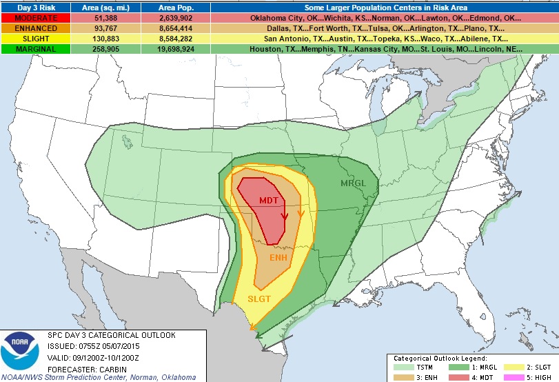
Severe Threat Saturday
Interestingly, according to Wikipedia, this is only the 14th time that a moderate risk has been issued for day 3!
...SUMMARY... A SEVERE WEATHER OUTBREAK APPEARS POSSIBLE ACROSS PARTS OF THE GREAT PLAINS ON SATURDAY. WIDESPREAD INTENSE THUNDERSTORMS SHOULD DEVELOP OVER PORTIONS OF OKLAHOMA...KANSAS...AND TEXAS DURING THE AFTERNOON. TORNADOES...VERY LARGE HAIL...AND DAMAGING WINDS ARE LIKELY IN THESE AREAS. ...SOUTHERN AND CENTRAL PLAINS... THERE IS INCREASING CONFIDENCE IN THE LARGE SCALE PATTERN EVOLUTION ACROSS THE SRN AND CENTRAL PLAINS THROUGH SATURDAY AS A POTENT AND PROGRESSIVE MID/UPPER DISTURBANCE EMERGES FROM THE ROCKIES AND SPREADS HEIGHT FALLS/ASCENT AND STRONG SHEAR ACROSS A WARM AND UNSTABLE AIRMASS. BY LATE SATURDAY AFTERNOON...THE INGREDIENTS SHOULD COME TOGETHER TO SUPPORT A SEVERE WEATHER OUTBREAK ACROSS THE SRN/CENTRAL PLAINS. ALTHOUGH THERE REMAIN UNKNOWN DETAILS WITH RESPECT TO MOST SIGNIFICANT THREAT AND STORM EVOLUTION...GENERAL PATTERN RECOGNITION AND REMARKABLE AGREEMENT IN LATEST GUIDANCE WITH RESPECT TO LARGE SCALE FORCING FOR ASCENT ASSOCIATED WITH HEIGHT FALLS/UPPER TROUGH AND JUXTAPOSITION OF INSTABILITY AXIS...AND CLIMATOLOGY...ALL SUPPORT A RELATIVELY HIGH CONFIDENCE FORECAST OF NUMEROUS INTENSE STORMS/SUPERCELLS CAPABLE OF PRODUCING VERY LARGE/DAMAGING HAIL AND A FEW STRONG/LONGER-LIVED TORNADOES IN THE MODERATE RISK AREA. THIS SCENARIO WILL UNFOLD AMIDST A VERY MOIST WARM SECTOR WHERE SFC DEW POINTS AROUND 70F SHOULD RESIDE AHEAD OF A SHARPENING DRYLINE EXTENDING SOUTH FROM DEEPENING LEE CYCLONE FROM SWRN KS SWD INTO W TX. 50-60 KTS OF SWLY 500 MB FLOW WILL PIVOT AROUND MID/UPPER LOW AND ACROSS OK/KS AS A SFC LOW CONTINUES TO STRENGTHEN THROUGH EARLY EVENING. BACKED LOW LEVEL FLOW BENEATH THE STRONG SWLY 500MB FLOW WILL RESULT IN HIGH SRH SUPPORTIVE OF POTENTIAL STRONG TORNADOES AS WELL AS VERY LARGE HAIL. INITIAL DISCRETE CONVECTION SHOULD GROW UPSCALE INTO CLUSTERS OR LINES THROUGH THE EVENING WITH SEVERE WIND...HAIL...AND FLOODING THREATS CONTINUING INTO THE NIGHT EAST ACROSS THE MISSOURI VALLEY AND SOUTH INTO TX.
Severe Threat Sunday
...DISCUSSION... THERE IS GENERALLY GOOD AGREEMENT AMONGST GLOBAL MODELS AND THEIR ENSEMBLES IN THE EVOLUTION OF THE CENTRAL U.S. CYCLONE MOVING OUT OF THE PLAINS ON SUN AND THEN ACROSS THE GREAT LAKES AND INTO SOUTHEAST CANADA THROUGH D5/MON AND TUE.
ACTIVE WARM CONVEYOR BELT AHEAD OF THE DEEPENING CYCLONE AND EXTENSIVE TRAILING COLD FRONT...FROM NEB/IA SOUTH TO ERN OK AND INTO TX...SHOULD MAINTAIN THE THREAT FOR SCATTERED SEVERE STORMS GIVEN LIFT WITH THESE FEATURES SPREADING EAST INTO A MOIST AND UNSTABLE AIRMASS. SOME TORNADO POTENTIAL MAY EVOLVE NEAR THE LOW CENTER AND WARM FRONT FORECAST TO MOVE OVER THE MIDDLE MISSOURI RIVER VALLEY...FROM ERN NEB TO IA...DURING THE DAY. FARTHER SOUTH ALONG THE COLD FRONT...CLUSTERS OF ORGANIZED STORMS...OR PERHAPS A BROKEN SQUALL LINE...WILL ALSO POSE SOME THREAT FOR DAMAGING WINDS AND HAIL.
Severe Threat Monday
A COHERENT SIGNAL FOR STRONG FORCING NEAR THE SURFACE LOW AND ALONG TRAILING FRONT...FROM SRN GREAT LAKES TO TX/LA GULF COAST...CONTINUES INTO THE D5 PERIOD ON MONDAY. WHILE TRAILING/SRN PORTIONS OF THE COLD FRONT...FROM ARKLATEX SOUTH...WILL BECOME FURTHER REMOVED FROM THE SYNOPTIC SCALE INFLUENCE OF THE MID/UPPER WAVE CROSSING THE MID/UPPER MS VALLEY...SEVERE POTENTIAL MAY STILL BE SUPPORTED IN THESE AREAS BY MODEST SHEAR AND RICH LOW LEVEL MOISTURE IN THE PRESENCE OF WEAKENING LIFT ALONG THE BOUNDARY. FARTHER NORTH...EITHER A BROKEN SQUALL LINE OR POSSIBLY DISCRETE SUPERCELLS MAY TAKE FORM AHEAD AND SOUTH OF THE SURFACE LOW FORECAST TO TRACK ACROSS LAKE MICHIGAN DURING THE DAY. HAIL...WIND...AND POSSIBLY A COUPLE TORNADOES MAY POSE A THREAT IN THESE AREAS.
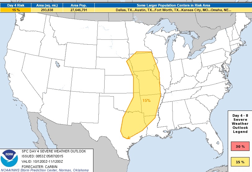
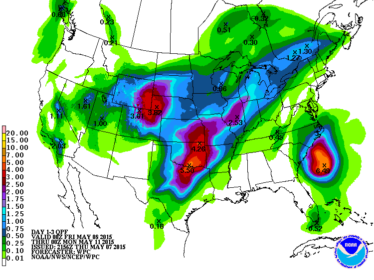
3 Day Precipitation Outlook
According to NOAA HPC, the 3 day rainfall forecast suggests pockets of heavy rainfall across parts of the Central U.S.. As much as 2" to nearly 5" or rain can't be ruled out in heavy thunderstorms through PM Sunday.
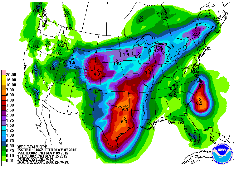
7 Day Precipitation Outlook
Ongoing shower and thunderstorm activity across the Central U.S. could lead to additional flood concerns through next week. According to NOAA's HPC, the 7 day rainfall forecast suggests nearly 3" to 6"+ in spots through PM Thursday! Also, note the significant blob of moisture near the Carolina coast due to our rogue Atlantic storm.
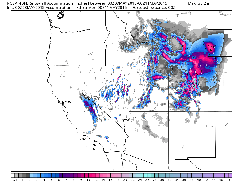
Western Snowfall
As our next storm system pushes through the Intermountain-West, snowfall will be likely across the high elevations. Some spots could see 6" to 12" or more through PM Sunday!
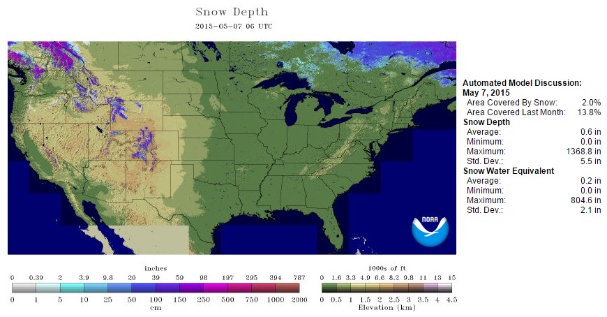
National Snow Cover 2015
We typically don't see a ton of snow cover across the nation at this time of the year, but according to NOAA's NOHRSC, 2% of the nation was covered as of May 7th.
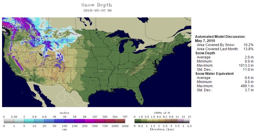
National Snow Cover 2010
I looked back through some of the more recent data and found that the greatest snow cover across the nation on May 7th was back in 2010. Note the heavy snow cover across the Sierra Nevada Range!
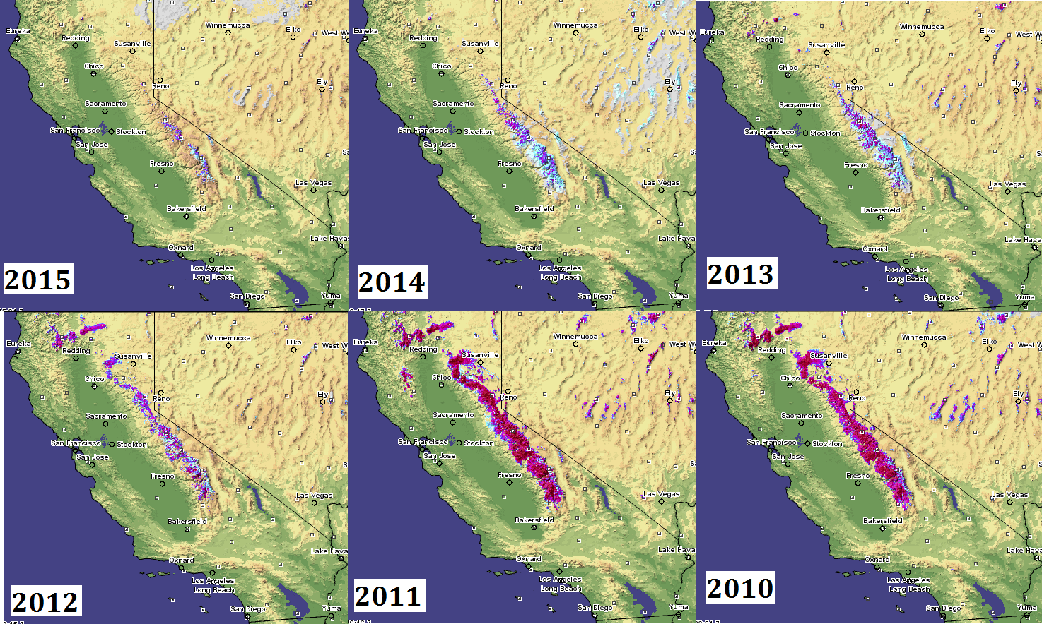
Dwindling Sierra Nevada Snow
Paging through the data a little more. I happened to noticed a pretty drastic trend in the amount of snow cover across the Sierra Nevada Range from 2010 to 2015. These were all snapshots on May 7th from 2010 to 2015.
______________________________________________________________________
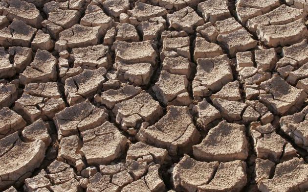
California Drought
"Political answers scarce as water in parched California"
"LOS ANGELES — For much of the century since William Mulholland, the visionary or villainous engineer who brought water from the Eastern Sierra to Los Angeles, opened the floodgates of his aqueduct and declared, “There it is. Take it!” Californians have done just that — and most of the time their political leaders haven’t had to worry too much about the result."
"But in the fourth year of the Golden State’s epic drought, the water shortage is having real consequences, not only for the everyday lives of residents, but for the policies and political fortunes of their elected officials as well. A crisis that is estimated to have cost the state’s economy more than $2 billion last year alone has upended an unsustainable status quo, and raised uncomfortable questions for politicians from Gov. Jerry Brown to local mayors."
Read more from Politico.com HERE:
(Image Courtesy: Tomas Castelazo via Wikipedia)
Thanks for checking in and have a great rest of your week/weekend ahead! Don't forget to follow me on Twitter @TNelsonWX

No comments:
Post a Comment